Mali Conflict Map: France Begins Intervention Against Religious Hardline Rebels (January 2013)

There are newer versions of this map available. To see them, view all Mali maps.   

Islamic extremist militants have ruled Mali’s vast northern region almost unopposed for half a year, after driving out the secular Tuareg-majority separatists who briefly declared an independent country there last spring. But everything changed last weekend, with a new rebel offensive and surprise French military intervention that have kicked the war back into full gear. Read on for a summary of events.
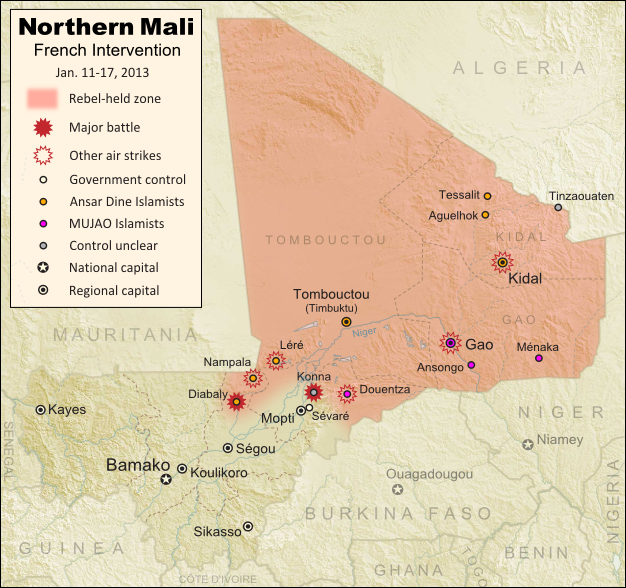
Map of fighting and territorial control in Mali during the January 2013 French intervention against the Islamist forces of Ansar Dine and MUJAO
Current territorial control and fighting in Mali (including French intervention). Map by Evan Centanni, modified from Wikimedia map by Orionist, using images by Carport and NordNordWest (source). License: CC BY-SA.

Map Updates: Check our Mali channel for frequent updates to this map.

Northern Mali in Rebel Hands
The rebellion in northern Mali began as a separatist struggle led by the National Movement for the Liberation of Azawad (MNLA), a secular group of mostly Tuareg ethnicity who last spring successfully seized Mali’s north and declared independence as the State of Azawad. But their victory was soon hijacked by Ansar Dine, a hard-line Islamist militia (also led by Tuaregs) that had fought alongside them previously. Ansar Dine was then joined by MUJAO, an Al Qaeda offshoot group, who swiftly expelled the MNLA from the region. (See: Independent Azawad No More: Northern Mali in Islamist Hands)

The closely allied Ansar Dine and MUJAO remained comfortably in control of northern Mali for the next half year. Citizens accused of immorality were brutally punished under an extreme interpretation of Islamic law, and ancient historical sites were destroyed for allegedly being un-Islamic. Meanwhile, Al Qaeda in the Islamic Maghreb (AQIM), the global terror organization’s Northwest African branch, was allowed to operate freely in the region. The U.N. Security Council eventually authorized a military intervention to be led by neighboring countries, but it was not expected to begin until next September at the earliest.

Further Reading: Making Sense of Mali’s Armed Groups (guide to militias from both sides)
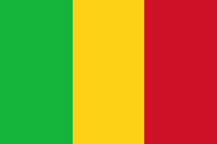
Flag of MaliCountry Name:  
• Mali (English, French, Bambara)
Official Name:  
• Republic of Mali (English)
• République du Mali (French) 
• Mali ka Fasojamana (Bambara)
Capital: Bamako

War Breaks Out
Everything changed last week, when Ansar Dine and MUJAO began an allied push to extend their territory southward towards Mali’s capital. On Thursday, the Malian army claimed (incorrectly) to have captured the important town of Douentza from the rebels, but in fact it was soon the Islamists who had taken new territory, the small central town of Konna.

Panic ensued as it appeared Sévaré, which hosts a critical military airport, and Mopti, a regional capital for central Mali, would be next. But the next day, the tables suddenly turned with the surprise arrival of hundreds of French troops (responding to a request from Mali’s president). At the same time, news hit that supporting forces from neighboring West African countries would be arriving within days.

Over the following night, French and Malian forces claimed to have taken Konna back from the rebels, amid a series of airstrikes against Islamist positions. However, by Monday the extremists had captured Diabaly, the nearest town yet to Mali’s capital and major population centers (though perhaps not as significant as it appears); and by Tuesday, the French government was denying that its forces had even recaptured Konna.

The situation in Mali is continuing to change by the hour (Diabaly is now reportedly surrounded by French and Malian troops, and there are unverified claims that Konna has finally been recaptured). Political Geography Now will be releasing frequent updates to the map as the conflict plays out. Stay tuned!

(To see only posts related to this conflict, you can filter the site for all Mali articles).

Note on Names:  
The acronym “MNLA” is based on the French name, and is sometimes rendered “NMLA” to match the English. 
“MUJAO” is also a French-based acronym. The English acronym is “MUJWA” (or sometimes “MOJWA”). 
Ansar Dine is pronounced “an-SAR (uhd)-DEEN” and sometimes spelled “Ansar Eddine” or “Ansar ud-Dine”. 
AQIM is also known by its French acronym “AQMI”; its Arabic actually means “Al Qaeda in the Islamic West”.

Graphic of Malian flag is in the public domain (source).

Central African Republic: Map of Rebel Control (January 2013)

Last month, rebels in the Central African Republic launched a sudden military campaign against the government, rapidly taking over city after city in their advance towards the capital. Fighting has now come to a temporary halt, with much of the country under rebel control. Read on for a summary of the conflict so far. 

Map of 2012-2013 rebellion in the Central African Republic, showing current rebel control as of January 11, 2013
Advance of Séléka rebels in the Central African Republic during December 2012 and January 2013. Map fact-checked and modified by Evan Centanni from this map by Wikimedia user Keitsist. License: CC BY-SA

Updated Map: Central African Republic – Map of Rebel Control (March 2013)

Rebellion in the Central African Republic
In 2007, a three-year civil war came to an end in the Central African Republic (CAR) when the government reached a peace agreement with several rebel groups. Yet six years later, some of the rebels feel that the government has still not honored its side of that agreement, and last month violence broke out once again.

The new fighting was initiated by a coalition of rebel groups calling itself “Séléka”, which means “alliance” in Sango, the national language of the CAR. The rebels have threatened to depose President François Bozizé, who took power in a 2003 coup but has since won two controversial elections.

More Background: BBC News Q&A – Central African Republic’s rebellion

Rebel Advance from the North
The rebel campaign began on December 10, when they took over N’Délé, a regional capital in the country’s north, which had been under the control of a government-allied former rebel group. At the same time, the new rebel coalition captured two other northern towns, Ouadda and Sam Ouandja. A week later, they stormed into Bria, a diamond-mining town and regional capital in the country’s east. By this time, their forces in N’Délé had also advanced south to capture the town of Bamingui.

Flag of the Central African RepublicCountry Name:  
• Central African Republic (English)
• Centrafrique (French)
• Bêafrîka (Sango)
Official Name:  
• Central African Republic (English)
• République centrafricaine (French)
•Ködörösêse tî Bêafrîka (Sango)
Capital: Bangui

Despite the Central African government receiving reinforcements from its ally and neighbor Chad, the Séléka rebels continued on the road to Bangui, taking the towns of Kabo and Batangafo in the next two days after the Bria attack (despite some sources indicating towns being retaken, government forces no longer seem to be in control of these places; however, rebel forces may not maintain a strong presence either).

In the following days, Séléka’s forces moved west from Bria, seizing the town of Ippy on the way to Bambari. The latter city, among the country’s largest, fell to the rebels on December 23. Central African government forces subsequently attempted to retake Bambari, but were held them back. Two days later, Séléka forces in the north captured another regional capital, Kaga-Bandoro, after only brief resistance.

The seizure of Bambari and Kaga-Bandoro paved the way for Séléka to advance on Sibut, the last regional capital on the road to Bangui. It was soon reported that the rebels had bypassed Sibut to avoid Chadian forces stationed there, and had instead proceeded to the next major town, Damara. However, a few days later rebel forces seized Sibut, and it became apparent that Damara was in fact still government-held, with Central African and Chadian troops having pulled back to there from Sibut.

Standoff and Ceasefire in the South
The rebels are now using Sibut as their forward base, while forces from neighboring countries are amassing in Damara as a firewall against any invasion of the national capital, Bangui. A contingent has also arrived from more distant South Africa. Aside from the rebel capture of Alindao (and possibly one other small town) near Bambari, fighting has come to a standstill since the end of December.

A temporary ceasefire was finally reached on Thursday between the Central African Republic government and Séléka, with word of a possible unity government in the near future if talks proceed smoothly. Political Geography Now will be watching the situation closely, and reporting promptly on any new territorial developments.

Graphic of the flag of the Central African Republic is in the public domain (source).

Somalia: Al Shabaab Map Update (Dec. 2012)

There are newer versions of this map available. To see them, view all Somalia articles on PolGeoNow.

Al Shabaab, Somalia’s local branch of Al Qaeda, has continued to gradually lose territory since government-allied forces captured its main stronghold two months ago. As a follow-up to our October feature on the two-year retreat of Al Shabaab, we now present the latest changes to the map of control in southern Somalia.

Map of Al Shabaab control in southern Somalia as of December 2012, highlighting recent advances by government and African Union troops since the capture of key port city Kismayo. Includes the December capture of Jowhar by Ugandan AU forces.
Southern Somalia: recent government-allied advances against Al Shabaab. Original map by Evan Centanni. Incorporates elements from this blank map by Eric Gaba and this locator map by TheEmirr. (license: CC BY-SA).

Slow Progress Against Al Shabaab
Somalia’s Islamic extremist militia, Al Shabaab, was greatly weakened when its biggest port and de facto capital of Kismayo was taken by government-allied African Union (AU) forces in October (See: The Retreat of Al Shabaab). However, it still controls a significant amount of territory, and the Somali and AU forces’ advance has been slow, with their first major territorial gain acheived only this past weekend.

Although our previous map suggested that Burhakaba east of Baidoa was under government-allied control at that time, it became clear soon after publication that the city was in fact still under the control of Al Shabaab. Most of the Somali/AU offensives over the last two months have centered on the goal of opening up the road from Mogadishu to Baidoa – an effort that has currently stalled about halfway between Wanlaweyne and Burhakaba.

Flag of SomaliaCountry Name:  
Somalia (English)
Soomaaliya (Somali)
• aṣ-Ṣūmāl (Arabic)
Official Name:  
Federal Republic of Somalia (English)
Jamhuuriyadda Federaalka Soomaaliya (Somali)
Jumhūriyyat aṣ-Ṣūmāl al-Fideraaliya (Arabic) 
Capital: Mogadishu

Kenyan-led AU and Somali troops also began an advance towards Jilib in the southwest (presumably along the road from Afmadow, since Jamaame hasn’t been reported captured), but have apparently not yet reached that objective either. The first major town to be taken from Al Shabaab since October is Jowhar, north of Mogadishu, which fell to Ugandan-led AU and Somali forces on Sunday.

Shifting Power Structures
In other developments, the pro-government ASWJ militia, which was among the first to make gains against Al Shabaab nearly two years ago, has formally agreed to join the Somali federal government and integrate into the national army. This means that the areas north of Al Shabaab’s territory, which have long been controlled autonomously by the ASWJ, will now theoretically fall under the jurisdiction of the national government.

In practice, much of this area is still patrolled by government-allied troops from Ethiopia, who invaded last year to push Al Shabaab back from their border, though the major cities of Baidoa and Beledweyne have since been handed over to AU peacekeepers. For a who’s-who of the many players in Somalia’s civil war, see our previous Somalia feature.

Graphic of Somali flag is in the public domain (source).

Somalia: The Retreat of Al Shabaab

There are newer versions of this map available. To see them, view all Somalia articles on PolGeoNow. 

One year ago, Kenya and Ethiopia invaded Somalia to end the rule of Al Shabaab, an Al Qaeda allied extremist group which had taken over the southern half of the country. This map and article are your guide to the militants’ slow but steady retreat, culminating in last week’s capture of the port city of Kismayo.

Map of the retreat of Al Shabaab Islamist militants in Somalia since 2011, culminating in the October 2012 capture of the key port city of Kismayo. Shows successive stages of advance by Kenyan, Ethiopian, and local forces.
The retreat of the Al Shabaab Islamist militant group in Somalia since 2011. Original map by Evan Centanni. Incorporates elements from this blank map by Eric Gaba and this locator map by TheEmirr. (license: CC BY-SA).

State of Anarchy
Located at the tip of East Africa’s “Horn”, Somalia has been wracked by chaos and violence since the fall of its last effective national government in 1991. While the northern Somaliland and Puntland regions formed autonomous governments, central and southern Somalia were ruled for many years by a patchwork of local warlords.


In recent years, the southern regions have been united under the hardline Islamist group Al Shabaab, though the extremists have been losing ground since early last year. Kenya and Ethiopia joined the fight one year ago, and last week a coalition of allied forces finally captured the extremists’ last major urban stronghold, the port city of Kismayo.

The Players: Who’s Fighting in Somalia?

Flag of SomaliaCountry Name:  
Somalia (English)
Soomaaliya (Somali)
• aṣ-Ṣūmāl (Arabic)
Official Name:  
Federal Republic of Somalia (English)
Jamhuuriyadda Federaalka Soomaaliya (Somali)
Jumhūriyyat aṣ-Ṣūmāl al-Fideraaliya (Arabic) 
Capital: Mogadishu

Al ShabaabThis movement originated as the hardline youth wing of the Islamic Courts Union (ICU), which ruled southern and central Somalia briefly in 2006. The group is officially a wing of Al Qaeda, though their relationship with the terrorist network has sometimes been strained.

Transitional Federal Government (TFG) – The internationally recognized government of Somalia, though it has often been limited to governing parts of the Somali capital, Mogadishu. Units from the TFG’s Somali National Army (SNA) have played a supporting role in the advances against Al Shabaab.

Kenya Defense Forces (KDF) – The military of neighboring Kenya invaded southern Somalia in October 2011 as retaliation against alleged Al Shabaab attacks on Kenyan soil. The early Kenyan campaign, approved by the TFG, was titled Operation Linda Nchi (“Protect the Country” in Swahili), and was Kenya’s first major war as an independent country.

Ethiopian National Defense Force – Another neighbor of Somalia, Ethiopia has sent forces into Somalia more than once in the past. Ethiopian involvement is unpopular among the Somali people, who see it negatively as a foreign invader; still, it has low-key approval from the TFG, and has played a key role in beating back Al Shabaab.

African Union Mission in Somalia (AMISOM) – An international peacekeeping force originally sent to protect the TFG in Mogadishu, AMISOM has since actively fought to drive Al Shabaab out of the capital and beyond. The force is made up of soldiers from Uganda, Burundi, and Djibouti, and also recently absorbed the invading Kenyan forces under its mandate.

Ahlu Sunna Waljama’a (ASWJ) – A moderate Sufi Muslim militia which operates out of Guriel in central Somalia and Dolo in the south, the ASWJ was the first group to make major gains against Al Shabaab, and has fought alongside the Ethiopians after the invasion. ASWJ is backed by Ethiopia and allied with the TFG, though its relations with the latter are sometimes tense.

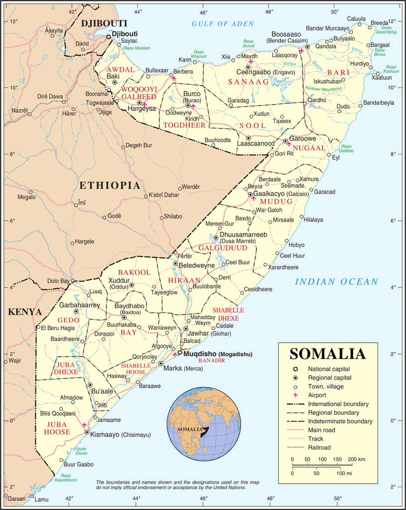
Complete map of Somalia (source)

Ras Kamboni – Named after the town at the far southwestern tip of Somalia where Islamists made a last stand against Ethiopia back in 2006, this splinter militia of the original Ras Kamboni Brigades has switched from being anti-Ethiopia to anti-Shabaab. Backed by Kenya, Ras Kamboni forces were the first to push the extremists back from the Kenyan border, and have continued making major contributions to the war effort.

Shabelle Valley Administration (SVA) – A would-be regional government for central Somalia, SVA forces fought alongside the Ethiopians, the ASWJ, and the TFG to liberate the city of Beledweyne. However, they have political disputes with the TFG and ASWJ, which also want control of the region.

The Events: Timeline of Al Shabaab’s Retreat

2011 Jan. –  Al Shabaab’s territory is at its greatest extent, after absorbing rival Islamic militia Hizbul Islam.

2011 Mar.-Apr. – ASWJ forces with Ethiopian and TFG support carve out a large area of territory near the Somali-Kenyan-Ethiopian border, taking regional capital Garbaharey near the end of April.

2011 Aug. 6 – Al Shabaab stages a major withdrawal from Mogadishu, the Somali capital, after suffering defeats at the hands of AMISOM. The militia’s forces will remain in the capital’s outskirts for many more months.

2011 Oct. 16-20 – Kenya launches a three-pronged invasion, entering through El Waq, Dhobley, and Ras Kamboni. ASWJ and the Ras Kamboni militia have already cleared the way, and the KDF initially extends their conquests only as far as Qoqani and Burgabo.

Flag of Al Qaeda, used as the war flag of Al Shabaab in Somalia.
The war flag of Al Shabaab is the banner of Al Qaeda, based on Muhammed’s Black Standard. Public domain graphic by Ingoman (source).

2011 Oct.-Dec. – Heavy rains leave Kenyan forces stuck in the mud, and time is spent defending from Al Shabaab’s guerilla attacks rather than advancing on the enemy. Meanwhile, Ethiopian troops begin crossing the border in large numbers.

2011 Dec. 31 – Ethiopian, ASWJ, TFG, and SVA forces capture Beledweyne, the largest city held by Al Shabaab in central Somalia.

2012 Feb. 9 – Al Shabaab publicly joins terrorist network Al Qaeda.

2012 Feb. 22 – Ethiopian and TFG troops seize Baidoa, a major city in the interior of southern Somalia which has been held by Al Shabaab since Jan. 2008.

2012 Mar. 16 – TFG and AMISOM forces expel Al Shabaab from their last remaining strongholds within Mogadishu.

2012 Mar. 22 – Hudur, a regional capital north of Baidoa, falls to TFG and Ethiopian forces.

2012 Mar. 26 – ASWJ and Ethiopian forces in central Somalia take El Bur, an important Shabaab base, but lose it again two months later.

Flag of Ahlu Sunnah Waljamaca (ASWJ), moderate Sufi Muslim militia in Somalia.
Flag of the ASWJ (source).

2012 May 25 – TFG and AMISOM troops capture Afgoye, a key town just outside Mogadishu.
 
2012 May 31 – Kenyan troops and Ras Kamboni finally capture Afmadow, a key town on the way to Kismayo, after originally hoping to take it during the first weeks of the invasion.

2012 July 6 –  KDF forces in Somalia are formally absorbed into AMISOM, technically ending the Kenyan invasion.

2012 Aug. 20 – The Transitional Federal Government reaches the end of its tenure, and is replaced by a new government in a limited election.

2012 Aug. 28 – Marka, Al Shabaab’s second most important port city, is secured by TFG and AMISOM forces moving west out of Mogadishu.

2012 Sep. 28 to Oct. 2 – TFG troops and Kenyan forces under AMISOM enter Kismayo, Al Shabaab’s last major urban stronghold and most important port city. The battle includes an amphibious invasion conducted by the Kenyan navy. After a few days of uncertainty, allied forces control the city.

Graphic of Somali flag is in the public domain (source).

Malawi’s Flag Change

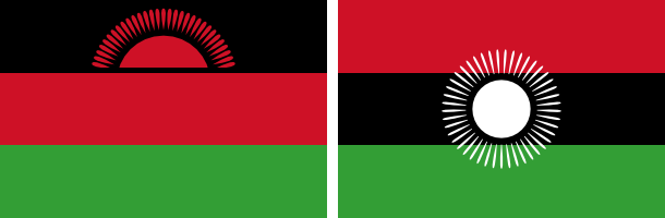
New and old flags of Malawi
Malawi’s original rising-sun flag (left) is being re-adopted, after being controversially replaced two years ago by the full-sun banner (right). Graphics are in the public domain (left source; right source).

Just two years after adopting a new flag, the southeast African country of Malawi is changing back to the old one. The original banner, in place from independence in 1964 until its replacement in 2010, was voted back in by the national parliament on May 28, 2012.

Flag of MalawiCountry Name:  
• Malawi (English)
• Malaŵi (Chichewa)
Official Name:  
• Republic of Malawi (English)
• Dziko la Malaŵi (Chichewa) 
Capital: Lilongwe

The independence flag, which displays a rising sun to represent the dawn of hope for Africa, was controversially replaced by President Bingu wa Mutharika two years ago. The colors were shuffled around to more closely match the Pan-African Flag, and the red rising sun was changed to a full white sun to symbolize the progress made by Malawi since independence.

When President Mutharika died last April, the Malawian government wasted little time in reverting the unpopular flag change. The move was supported by newly sworn-in President Joyce Banda, who had recently experienced a falling-out with Mutharika and started a new political party.

Although the flag change vote passed in parliament, it is still unclear whether it has passed officially into law via the required presidential signature. In any case though, the rising-sun flag appears to be widely in use again, being flown in the Olympics and displayed on many official websites (except for the main government homepage).

Independent Azawad No More: Northern Mali in Islamist Hands

There are newer versions of this map available. To see them, view all Mali maps.   

Since declaring the independence of Azawad in April, control by northern Mali’s MNLA rebels has been usurped by the hardline Islamists of Ansar Dine and MUJAO. The new regime, while still bitter enemies of the Malian government, does not claim independence. Presented here is a map and brief guide explaining the current situation.

Map of Islamist rebel control in northern Mali as of September 2012
Area held by Islamist rebel groups Ansar Dine and MUJWA in northern Mali. Map by Evan Centanni, modified from Wikimedia map by Orionist, using images by Carport and NordNordWest (source). License: CC BY-SA.

Separatists vs. Islamists
Last April, the Tuareg-dominated separatists of the National Movement for the Liberation of Azawad (MNLA) swept into victory in northern Mali, completing their control of the region and declaring independence as the State of Azawad. But their victory was won only with the support of Ansar Dine, an Islamist militia led by veteran Tuareg fighter Iyad Ag Ghaly. The MNLA and Ansar Dine then alternated between cooperation and conflict for months, with the Islamists grabbing ever more control of the region’s cities.

Tensions came to a head on June 26, when a second Islamist group, the Movement for Unity and Jihad in West Africa (MUJWA), violently expelled the MNLA from their capital city of Gao. By month’s end, Ansar Dine had fully pushed the MNLA out of key city Timbuktu, and two weeks later the separatists were driven from their last stronghold in the town of Ansongo. Then just this weekend, MUJWA again made news by seizing the town of Douentza from a formerly cooperative local militia.

Flag of MaliCountry Name:  
• Mali (English, French, Bambara)
Official Name:  
• Republic of Mali (English)
• République du Mali (French) 
• Mali ka Fasojamana (Bambara)
Capital: Bamako

Though northern Mali is still not controlled by the national government in Bamako, the Islamist militias do not seek independence. Instead, they pursue a vision of strict sharia law throughout Mali. Since these new rulers no longer consider Azawad a sovereign nation, its claim to independence has faded away.

Current Rebel Control
Ansar Dine and MUJWA together appear to hold all of the territory originally seized by the MNLA, with the line of control lying between the towns of Douentza and Sévaré. Bandiagara in the nearby Dogon region may have an army presence, but other towns such as Koro do not, and have seen rebel raids.

Administration is divided between the two Islamist militias, with Ansar Dine apparently controlling regional capitals Timbuktu and Kidal, and MUJWA controlling at least Gao (also a regional capital) and Douentza. Al Qaeda in the Islamic Maghreb (AQIM), a branch of the terrorist group, also maintains a strong presence in northern Mali. MUJWA is historically associated with AQIM, though Ansar Dine’s relationship to the organization is more tenuous.

Special thanks to Peter Tinti (@petertinti), who has provided invaluable commentary throughout the Mali conflict, and has repeatedly pointed me in the right direction in my research.

Note on Names:  
The acronym “MNLA” is based on the French, and is sometimes rendered “NMLA” to match the English. 
MUJWA is also known as “MOJWA” (from an alternate translation) or “MOJAO” (from the French). 
Ansar Dine is pronounced “an-SAR (uhd)-DEEN” and sometimes spelled “Ansar Eddine” or “Ansar ud-Dine”. 
AQIM is also known by its French acronym “AQMI”; its Arabic actually means “Al Qaeda in the Islamic West”.

Graphic of Malian flag is in the public domain (source).
Kosovo Recognized by Chad (Total: 91/193)

Map of countries that recognize the Republic of Kosovo as independent, updated for June 2012
Countries recognizing the Republic of Kosovo in green, with the most recent, Chad, in lighter green (click to enlarge). Kosovo in magenta. Map by Evan Centanni, modified from public domain wiki map (source).

Flag of the Republic of KosovoCountry Name:  
• Kosovo (English, Serbian)
• Kosova (Albanian)
Official Name:  
Republic of Kosovo (English)
Republika e Kosovës (Albanian)
Republika Kosovo (Serbian)
Capital: Priština

Kosovo Recognition Update
In the month or so since our last report on Kosovo, one more U.N. member country has offered diplomatic recognition to the breakaway state. Chad, a diverse country in Central Africa, recognized the Republic of Kosovo on June 1, one month after a meeting between their Foreign Ministers. A southeastern European state which seceded from Serbia in 2008, Kosovo is now officially considered independent by 91 U.N. member countries (47%) plus non-member Taiwan. It has not been admitted as a member of the U.N., due to objections from Serbia, Russia, and other countries which consider it to be part of Serbia. For more on Kosovo’s special situation, see Kosovo Diplomatic Recognition Continues.

Stay Updated: Check for more recent posts by viewing all Kosovo articles on Political Geography Now.

Flag graphic by Cradel (source). License: CC BY-SA

Map: Sudan & South Sudan’s Disputed Territories

Countries: South Sudan, Sudan
Official Names: Republic of South Sudan, Republic of Sudan
Summary: After South Sudan declared independence from Sudan last year, much of the border between the neighbors is still hotly disputed, with recent violent clashes around the Heglig oil field and other areas. Read on for a full list of Sudan and South Sudan’s eight major border flashpoints.

Map of the border between Sudan and South Sudan, marking selected territorial disputes and border clashes in 2012. Includes inset map of April fighting in region of Heglig oil field.
Border map of Sudan and South Sudan, showing disputed areas and fighting since the beginning of 2012. Aerial bombings and attacks by rebel groups not shown. My own work, using blank Sudan and South Sudan maps by NordNordWest / Wikipedia. License: CC BY-SA.


About the Sudan-South Sudan Border Conflict
Nearly one year after South Sudan separated from Sudan, the precise location of the border between the two countries has still not been agreed upon and demarcated (marked on the ground). An approximate border line has been drawn on the map following the route of an old internal boundary between the northern and southern regions of colonial Sudan – known as the “1956 border”, for the last date it was in effect before Sudanese independence. But its implementation is so messy that the two sides can’t even agree on how much is disputed, with Sudan claiming that 80% of the border has already been effectively agreed upon, while South Sudan says it’s only 40%. Last month, tensions boiled over into a small border war centered on Heglig, a northern-administered oil town claimed by South Sudan. Fighting spread briefly to other border areas, and many locations in the south were bombed by Sudanese planes.

Photographs: Pete Muller on the Sudan-South Sudan front lines

The following article profiles eight hotly contested or widely acknowledged disputed areas along the border between Sudan and South Sudan. (Note on spellings: Many of these place names come from Arabic or other local languages, and do not have agreed-upon English spellings. Alternate spellings are indicated in parentheses).

Heglig (Panthou)
(Also spelled Higlig or Hijlij)
The small, remote oil town of Heglig, known as Panthou to South Sudan, is apparently located on northern Sudan’s side of the 1956 border. However, older maps don’t label the town at all, and until 2003 it was administered as part of Unity State in the Southern Sudan region. Then, just after the Sudan government and the future independent South had agreed not to share oil from north of the border, the government abruptly informed the southerners that Heglig in fact belonged to the north’s Southern Kordofan state.

Further Reading: Note on Panthou/Heglig (PDF) – History and legal status

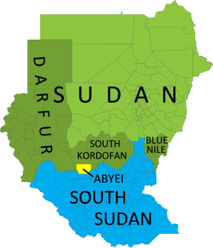
Map of current administrative areas of the former Sudan, distinguishing South Sudan, Sudan (plus areas with active rebellions), and the disputed Abyei area, which is jointly administered and policed by U.N. peacekeepers.
The former Sudan’s current administrative areas. Blue: South Sudan. Green: Sudan (darker green: states with active rebellions). Yellow: joint administration and U.N. peacekeeping force. Modified from this map by Wikimedia user Lokal_Profil (CC BY-SA 2.5).

Minds in the south weren’t changed so easily, and after two weeks of border clashes starting in late March of this year, South Sudan invaded Heglig. The southern government claimed they were only retaliating against earlier attacks by the north, but Sudan and the U.N. denounced it as an act of aggression. The South Sudanese army occupied Heglig from April 10-20, and advanced nearly as far as Kharasana (also Kersana, Karasana, Karasanah) before turning back – whether out of defeat or in order to stem international criticism is not clear. The front line has since moved back to Teshwin (also Tachiuen, Tishwin, Tashwin), an uninhabited spot on the 1956 border. Sudanese air strikes during the confrontation occurred deep within South Sudanese territory (PDF), including in Unity State’s capital of Bentiu, as well as Panakuac (also Pan Akuach, Pana Kuach), a military position on the road to Teshwin.

Video: Journalists witness Sudanese air raid

Abyei Area
Perhaps the most well known of the disputed regions along the border of the two Sudans, this region was singled out for special treatment in the 2005 agreement which led to Southern independence. Centered around the town of Abyei, the territory was to have its own referendum vote on whether to join South Sudan or remain part of the north. However, due to disagreements last year over who could to vote, the referendum failed to happen and the northern Sudanese Armed Forces (SAF) occupied the territory. Abyei is officially co-administered by the north’s South Kordofan state and the south’s Northern Bahr el Ghazal state, with security handled by a U.N. peacekeeping contingent called UNISFA; however, the part of the area north of the Bahr el Arab (Kiir) River is still occupied by the Sudanese army (PDF). South Sudan until recently maintained a police force in the area south of the river, but pulled it out two weeks ago at the demand of the U.N. Security Council (the north has defied the same order). [Update: Sudan finally withdrew its troops from Abyei on May 29.]

Kafia Kingi area
(Also spelled Kafia Kinji, Kafiya Kinji)
This is the largest of the regions disputed between Sudan and South Sudan, with its own confused history. Sudan seems to have transferred the area from the south’s Western Bahr el Ghazal state to the north’s South Darfur state in 1960 – too late to make it part of the north under the 1956 borders. However, some documents suggest it may have already been transferred by the British in the 1930’s (before 1956, making the transfer still valid today). In addition to the town of Kafia Kingi itself, the area also includes the copper mining town of Hofrat en Nahas (also Hufrat an Nuhas, Hufrat al Nahas) and the border town of Kafan Dabi (also Kafindabei, Kafn Dubai, Kafan Dibi), which was recently “recaptured” by the north.

Further Reading: Contested Borderlands: The Kafia Kingi Enclave

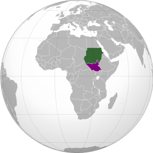
Map showing location of Sudan and South Sudan on a globe.
Location of Sudan (green) and South Sudan (purple) in Africa. Modified from this map (license: CC BY-SA).

Jau
(Also spelled Jao, Jaw)
Located right on the north-south border, this town on the frontier of Unity State and South Kordofan rose briefly to prominence after South Sudan claimed Sudan occupied their territory there last December, eventually leading to a victorious southern campaign to recapture the town in February. Rebel groups in the north simultaneously claimed credit for the victory, reinforcing Sudan’s accusation that the rebels are supported by the South Sudan government.

Bahr el Arab (Kiir) River
Called “River of the Arabs” by the north, and the Kiir River by the South, this is a locally important waterway that intersects the Abyei Area after running somewhat north of the 1956 border for a few hundred kilometers through South Darfur state. However, locals insist that the river is the real border, though it is unclear whether the South Sudan government itself actually claims the south bank. During last month’s outbreak of border warfare, fighting occurred in the riverside village of Kiir Adhem (also Kiir Adem, Kiir Adham), as well as a location known as Warguet, north of Aweil town in Northern Bahr el Ghazal state.

Kaka
This town on the White Nile river is located south of the 1956 boundary, within the state of Upper Nile. However, during the colonial era, the British allowed the town’s port to be administered by what is now Sudan’s Southern Kordofan state, and northern farmers over time established themselves in the Kaka area as well. South Sudan, however, argues that the town’s northerner administration did not make it technically a part of the north. Kaka has not been a flashpoint for fighting in recent months, but it remains on an agreed-upon list of disputed border areas. (Source: International Crisis Group report on Sudan north-south border)

Megenis Mountains
(Also Jebel Megenis, Magenis, Al-Muquinis Mountain)

Flag of Sudan (source)

An outcropping of large hills rising several hundred meters over the surrounding plain (Google Maps), the Megenis Mountains are divided between Sudan’s White Nile and South Kordofan states and South Sudan’s Upper Nile state. Sudan claims the whole area as the traditional realm of one of its local peoples, but there are also rumors of oil lying beneath the ground, and this may be the real reason that Megenis remains on the list of territorial disputes. (Source: International Crisis Group report on Sudan north-south border)

Flag of South Sudan (source)

Jodha
(Also spelled Jordah, Goda)
This dispute arises from a history of multiple changes to the border between Renk County in the south’s Upper Nile state and Jebeleyn (or Jabalain) County in the north’s White Nile state. Although locals dispute the whole eastern half of the boundary between the two states, the governments of Sudan and South Sudan designated only a small area near the present-day border crossing of Jodha as a recognized territorial dispute. (Source: International Crisis Group report on Sudan north-south border.) During last month’s widespread border conflict, fighting broke out in the nearby town of Kuek, though some sources claimed South Sudan’s army faced an independent militia rather than the Sudanese Armed Forces.

Sources for map locations:
Situation Map: Sudan-South Sudan border areas (27 April, 2012) (PDF). U.N. Office for the Coordination of Humanitarian Affairs (OCHA).
Policy Briefing: Sudan: Defining the North-South Border. International Crisis Group.
Map of Southern Kordofan and Abyei. U.N. Cartographic Section.
South Darfur Planning Map: All Settlements. Humanitarian Information Center for Darfur.  
Sudan: Population Movement. International Federation of Red Cross and Red Crescent Societies.

Declaration of Independence of Azawad (English Translation)

Country Name: Azawad (English, Tuareg, French), Azawād (Arabic)
News Categories: New Countries, Breakaway States, Unrecognized States
Full Story: New Country: Azawad Declares Independence from Mali

Flag of Azawad (image by Orionist; source)

Presented here is the full text of the Declaration of Independence of Azawad, originally posted in French to the website of the National Movement for the Liberation of Azawad (MNLA) on April 6, 2012, and translated into English by Evan Centanni of Political Geography Now. The MNLA is a Tuareg-led rebel group which has recently achieved control of the northern part of Mali in West Africa. For a history of the 2012 Tuareg rebellion in Mali, view all Mali posts on Political Geography Now.

Original Document: Declaration of Independence of Azawad (French)

**********************

DECLARATION OF INDEPENDENCE OF AZAWAD
[Unofficial translation by Political Geography Now]
WE, THE PEOPLE OF AZAWAD,
By the voice of the National Movement for the Liberation of Azawad after consultation with:
  • The Executive Committee,
  • The Revolutionary Council,
  • The Advisory Council,
  • The Staff of the Liberation Army,
  • The regional bureaus
Recalling the principles of international law and the principle international legal instruments governing the right of peoples to self-determination, particularly Articles 1 and 55 of the United Nations Charter, and the relevant provisions of the international Declaration of the Rights of Indigenous Peoples;
Considering the will expressed explicitly in the letter dated 30 May, 1958, addressed to the French president by the notables, spiritual leaders of all constituent parts of AZAWAD;
Considering that in 1960, on the occasion of the granting of independence to West African peoples, France attached AZAWAD without its consent to the Malian state that France had just created;
Recalling the massacres, the atrocities and abasement, the plundering and genocide of 1963, 1990, 2006, 2010 and 2012, which targeted exclusively the people of AZAWAD up until 1 April 2012;
Recalling the inhumane conduct of Mali, which utilized the various droughts (1967, 1973, 1984, 2010, etc.) to eradicate our people by devastation even as it sought and obtained generous humanitarian support;
Considering the accumulation of more than 50 years of bad governance, of corruption and of military-political-financial collusion, threatening the existence of the people of AZAWAD and imperiling regional stability and international peace;
Considering the complete liberation of the territory of AZAWAD;
Proclaim irrevocably the INDEPENDENT STATE of AZAWAD starting from this day, Friday, 6 April, 2012.

WE DECLARE:
  • Recognition of existing borders with neighboring states, and their inviolability;
  • Full adherence to the UN Charter;
  • The firm commitment of the MNLA to create conditions for lasting peace, to introduce the institutional foundations of the state based on a democratic constitution for independent Azawad.
The Executive Committee of the MNLA invites the entire international community in a spirit of justice and peace to recognize without delay the independent state of AZAWAD.
The Executive Committee of the MNLA, until the establishment of the Authority of the Territory of AZAWAD, will continue to manage the entirety of the territory.


GAO – 2012/04/06

SECRETARY-GENERAL – MNLA

BILLAL AG ACHERIF

New Country: Azawad Declares Independence From Mali

Country Name: Azawad (English, Tuareg, French), Azawād (Arabic)
News Categories: New Countries, Breakaway States, Unrecognized States
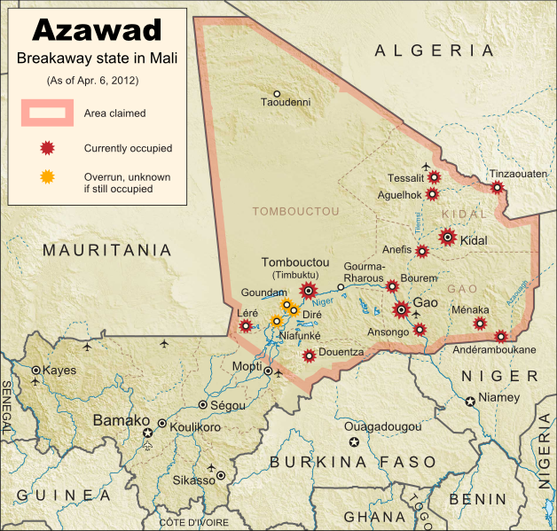
Summary: Tuareg-led rebels in northern Mali have declared “the independent state of Azawad”, after taking control of all of the region’s major cities and military bases and advancing to near the edge of their claimed territory. Azawad is not recognized as an independent country by any U.N. members, making it an example of a so-called “breakaway state”.

Map of the new independent state of Azawad, declared by MNLA Tuareg rebels in northern Mali. Shows claimed territory and towns controlled by the rebels group as of April 6, 2012
Map of State of Azawad, declared by the Tuareg-majority MNLA rebel group in Mali. Modified from Wikimedia map by Orionist, incorporating images by Carport and NordNordWest (source). License: CC BY-SA.

See Also: Mali Divided by Separatist Fighting; all Mali map updates

MNLA Claims Independent Azawad
The National Movement for the Liberation of Azawad (MNLA) today declared independence from Mali via a statement in French on its website. The rebels of the MNLA, mostly from the Tuareg ethnic group of the Sahara Desert, claim that the northern region of Mali, which they call Azawad, was wrongly included in that country when it declared its independence from France in 1960. There has not yet been any announcement on what form of government Azawad will have, or on which city will be its capital, but the MNLA says it is committed to democracy, to following the rules of the U.N., and to respecting the borders of other countries in the region.

Full Text: Declaration of Independence of Azawad (English Translation)

Flag of the independent state of Azawad, as claimed by the MNLA Tuareg rebel group in northern Mali
Flag of Azawad (image by Orionist; source)

The breakaway state of Azawad is not yet recognized diplomatically by any of the world’s other countries, and is unlikely to be any time soon. It joins the ranks of the various wholly or partially unrecognized states of the world, including fellow African state Somaliland, which similarly controls its whole territory despite complete lack of recognition from either the U.N. or other states. This status will likely prevent Azawad from appearing on mainstream world maps for some time to come.

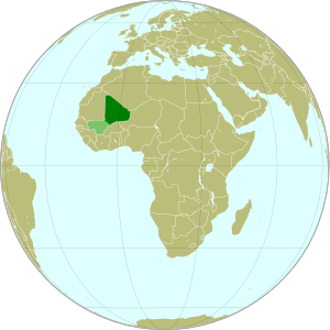
Map showing the location of the new state of Azawad in Africa, declared by the MNLA Tuareg rebel group in northern Mali
Azawad (dark green) and remainder of Mali (light green) in
Africa. Modified from this Wikimedia map (public domain).

Update on Territorial Control
Since our last map update, the Tuareg rebels of the MNLA advanced as far as the town of Douentza (according to their own claims, which have not been disputed), after which they declared a ceasefire, saying they had completed their mission to liberate Azawad. The town of Niafunké has also apparently switched hands a few times over the last few months (source in French), with its current situation unclear. The reality is that the Malian military probably no longer controls anything within the claimed territory of Azawad. Towns not shown as rebel-controlled on the map may simply not be occupied by anyone.

However, the new state of Azawad now faces a threat from another direction – the Islamist Ansar Dine militia, which fought alongside the MNLA over the last few months (with or without their approval). Ansar Dine is now attempting to install strict Sharia (Islamic law) in the cities, in opposition to the MNLA’s claimed desire for a secular state. An additional complication is that Ansar Dine in fact does not support independence for Azawad, believing instead that Sharia law should be instated throughout Mali. Ansar Dine is also a Tuareg-led group.

Seen this Mali conflict map on Wikipedia?
While Political Geography Now sometimes uses free maps from Wikipedia or other sites (after double-checking their sources), we also occasionally post our own maps to Wikipedia and Wikimedia Commons for others to use. The first version of this particular map of the Tuareg-led rebellion in Mali was created for Wikipedia by Orionist, but I have since taken charge of keeping it updated, with a bit of help from Mnmazur on Wikimedia Commons (Mnmazur is not associated with Political Geography Now).