Mali Conflict Map: Separatist Capture Timbuktu and Gao (April 2012)

Country Name: Mali (English, French, Bambara)
Official Name: Republic of Mali (English), République du Mali (French)
News Category: Divided Countries
Summary: Tuareg-led rebels in northern Mali have now completed their control of the region’s major cities, after capturing the military headquarters in Gao as well as historic Timbuktu. Meanwhile, Mali has been suspended from regional organization ECOWAS in response to the recent coup d’etat in the capital, Bamako.

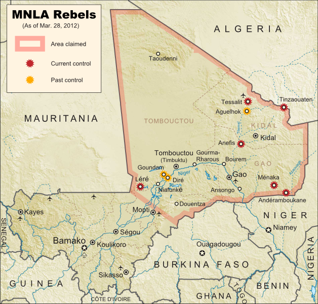
Map of Tuareg rebellion in Northern Mali (Azawad), showing towns controlled by the MNLA rebel group as of April 1, 2012
Towns captured by the Tuareg-majority MNLA rebel group in Mali. Modified from Wikimedia map by Orionist, incorporating images by Carport and NordNordWest (source). License: CC BY-SA.

Full Story: Mali Divided by Separatist Fighting; all Mali map updates

Conflict Update
Again immediately following our last update, northern Mali’s National Movement for the Liberation of Azawad (MNLA), made up mostly of Saharan Tuareg people, has followed its victory in Kidal by capturing the region’s other two major cities. On March 31, the rebels took control of Gao, headquarters of the Malian military in the north, and the next day overran Timbuktu, a historic former trading post and modern tourism destination. The town of Aguelhok in the north is now also being reported as under Tuareg control, though it is unclear when it was recaptured (the rebels had previously taken and lost it again back in January).

The military government of Mali, which took over in a recent coup d’etat, has now withdrawn its forces from most of northern region, known to the Tuareg rebels as Azawad. Neighboring countries have offered military assistance only if the country returns to democracy, and have suspended Mali’s membership in the Economic Community of West African States (ECOWAS) while imposing tough sanctions. If help doesn’t come soon, the MNLA could be in the position to declare independence in the north, making Azawad Africa’s newest country.

Follow events as they develop on Political Geography Now! To see only stories about this ongoing conflict, filter posts using the Mali label.

Seen this map on Wikipedia?
While Political Geography Now sometimes uses free maps from Wikipedia or other sites (after double-checking their sources), we also occasionally post our own maps to Wikipedia and Wikimedia Commons for others to use. The first version of this particular map of the Tuareg-led rebellion in Mali was created for Wikipedia by Orionist, but I have since taken charge of keeping it updated, with a bit of help from Mnmazur on Wikimedia Commons (Mnmazur is not associated with Political Geography Now).

Mali Conflict Map: Separatists Capture Kidal (March 2012)

Country Name: Mali (English, French, Bambara)
Official Name: Republic of Mali (English), République du Mali (French)
News Category: Divided Countries
Summary: Tuareg-led rebels in northern Mali have taken the important city of Kidal, as well as two other towns, and are now advancing on Gao, the northern headquarters of the Malian military.

Map of Tuareg rebellion in Northern Mali, showing towns controlled by the MNLA rebel group as of March 31, 2012
Towns captured by the Tuareg-majority MNLA rebel group in Mali. Modified from Wikimedia map by Orionist, incorporating images by Carport and NordNordWest (source). License: CC BY-SA.

Full Story: Mali Divided by Separatist Fighting

Conflict Update
Right on the heels of our last Mali map update, the Tuareg-led rebels of the National Movement for the Liberation of Azawad (MNLA) have made a great deal of further progress, including their biggest victory yet. Yesterday the rebel group captured Kidal, one of the three main cities in northern Mali (the region in which they hope to establish an independent country called Azawad). This time, it was widely reported that the MNLA was working together with Ansar Edine (or “Ansar Dine”), an Islamist group also led by a veteran Tuareg fighter, but which the other rebels had formerly shunned.

Just after overrunning Kidal, the MNLA was reported to have taken the towns of Bourem and Ansongo on either side of Gao, a key city containing the northern headquarters of the Malian military. Malian troops had previously announced their withdrawal from those two towns in order to focus their defense on the city. Now, the Tuareg fighters have entered the city of Gao, and are currently fighting to take the two military bases there. Follow events as they develop on Political Geography Now! To see only stories about this ongoing conflict, use the Mali filter.

Mali Conflict Map: Separatists Gain Ground in North (March 2012)

Country Name: Mali (English, French, Bambara)
Official Name: Republic of Mali (English), République du Mali (French)
News Category: Divided Countries
Summary: The rebellion of Tuaregs and other ethnic groups in northern Mali has continued gaining territory, and now threatens major cities in the north, where the rebels seek to establish an independent country called Azawad. Meanwhile, Malian military leaders upset with their government’s handling of the rebellion have taken over the country in a coup, leading to increased chaos on the country’s suspension from the African Union.

Map of Tuareg rebellion in Northern Mali, showing towns controlled by the MNLA rebel group
Towns captured by the Tuareg-majority MNLA rebel group in Mali. Modified from Wikimedia map by Orionist, incorporating images by Carport and NordNordWest (source). License: CC BY-SA.

Full Story: Mali Divided by Separatist Fighting

Conflict Update
After a month with no territorial gains or losses reported, on March 11 the National Movement for the Liberation of Azawad (MNLA) captured of the town of Tessalit in Mali’s far north. Home to a major military base and an airport, Tessalit was a major prize for the rebels, most of whom come from the traditionally nomadic Tuareg ethnic group. Their push for independence continued two days later with the storming of Diré and Goundam, two towns near the major northern city of Timbuktu, though it is unclear whether those two towns are still occupied by the MNLA.

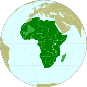
Map of the African Union, marking suspended members Mali and Madagascar
The African Union (green) with suspended members
Mali and Madagascar in lighter green. Modified from
this Wikimedia map (public domain).

An unexpected turn of events came on March 21, when the Malian government fell in a military coup. The leaders of the takeover cited President Amadou Toumani Toure’s ineffectiveness at combating the Tuareg revolt in the north as their reason; ironically however, the chaos caused by the coup has proved beneficial to the rebels, who on March 23 captured the town of Anefis on the road between Gao and Kidal, two of the north’s major cities. The MNLA has boasted that it will soon take those two cities, as well as Timbuktu, and recently it has indeed been reported that Malian troops in Kidal are negotiating a surrender after the city was surrounded by Tuareg militias.

In the confusion, another Tuareg-led rebel group, the Islamist Ancar Dine, has also claimed to control the towns of Tinzaouaten, Tessalit, and Aguelhok, which according to most other sources are actually held by the MNLA. Though the two rebel groups have a share a history of being formed by leaders of former Tuareg rebellions, some local experts doubt that they are actually working together. Meanwhile, the coup in Mali’s capital city of Bamako has resulted in the country’s suspension from the African Union (AU), an important regional organization which includes every country in Africa except for Morocco. Mali is one of only two currently suspended AU states, the other being Magascar, which also experienced a coup d’etat several years ago.

(Note: For updates to the Mali conflict map, follow the Mali label on Political Geography Now.)

Mali Divided by Separatist Fighting (February 2012)

Country Name: Mali (English, French, Bambara)
Official Name: Republic of Mali (English), République du Mali (French)
News Category: Divided Countries
Summary: Several towns in the African country of Mali have fallen out of government control this month, taken over by a separatist group known as the National Movement for the Liberation of Azawad (MNLA). The rebels are led by members of the Tuareg ethnic group, traditionally nomadic inhabitants of the Sahara Desert, who dwell in Mali’s northern regions and have a long history of conflict with the national government.

Towns captured by the MNLA rebel group in Mali. Modified from Wikimedia map by Orionist, incorporating images by Carport and NordNordWest (source). License: CC BY-SA.

(Note: For updates to this map, follow the Mali label on Political Geography Now.)

Full Story
One of the many African states formed based on arbitrary borders from the European colonial era, Mali is divided into two visibly distinct regions which are both geographically and ethnically distinct. The southern area, which hosts the majority of the population, has a tropical climate and is dominated by the Bambara and other West African peoples, while the northern region is located in the Sahara Desert, historically the domain of the Tuareg nomads. Over the last century, there have been at least four separate rebellions led by Tuareg people, many of whom feel their homeland should never have been included in Mali in the first place. Now, the recently formed National Movement for the Liberation of Azawad (MNLA) has begun one more uprising against Mali, with better chances of success than ever before.

Proposed flag of Azawad (image by Orionist; source)

Country Profile: Mali (Wikipedia)

The war began on January 16th of this year, when MNLA forces launched an attack on the town of Ménaka, the next day taking control of that location as well as the towns of Aguelhok and Tessalit, both of which lie in the area bordering the rebels’ bases in the mountains of the Kidal region. On January 18th, the Malian army apparently recaptured all three towns, but the MNLA was not deterred. After another unsuccessful takeover of Aguelhok on January 24th, the revolutionaries finally captured and held onto the towns of Andéramboukane and Léré on the 26th, penetrating unusually far into the south of the country. On February 1st, rebels again captured Ménaka after government forces withdrew from the town, and one week later the MNLA secured the border town of Tinzaouaten, driving their opponents from the Malian military across the border into Algeria. The city of Kidal also saw fighting in February, and the conflict continued throughout the month, though no further territorial gains by the MNLA have been reported in the last three weeks.

Running Summary of News on the Uprising:  “2012 insurgency in the Azawad” (Wikipedia)

Positions of Mali (dark green) and Libya (light green) in
Africa. Modified from this Wikimedia map (public domain).

The MNLA, although composed largely of Tuareg people, has also made a major effort to include Arabs, Songhai, and other peoples of “Azawad” (Northern Mali), where it hopes to establish an independent country. However, not all northerners support the revolt; Tuareg, Arabs, and members of other groups are fighting on both sides of the conflict. The MNLA is much better armed than previous revolutionary groups, partly because many exiled Tuareg rebel leaders have recently returned to Mali from nearby Libya – many of these veteran revolutionaries were employed and armed by the Libyan government, and eventually ended up fighting on both sides of that country’s 2011 civil war (a part of the Arab Spring revolutions). However, this new uprising also has the advantage of being the best organized yet, and of commanding a vastly more effective public relations network than ever before. The Malian government has also accused the rebels of being in league with Al Qaeda in the Islamic Maghreb (AQIM), a local affiliate of the worldwide terrorist organization; however, evidence for this is scant, and many from the MNLA in fact consider AQIM to be among their greatest enemies.

Further Reading: “The Causes of the Uprising in Northern Mali” – Think Africa Press (excellent in-depth background and analysis by a Northern Mali expert)

Sources
2012-1-26. “Tuareg rebels attack fifth town in Mali”. Al Jazeera.
2012-1-31. “Tuareg rebels take Mali town after army pullout”. AFP.
2012-2-2. Stewart, Scott. “Mali Besieged by Fighters Fleeing Libya”. Stratfor Global Intelligence.
2012-2-6. Morgan, Andy. “The Causes of the Uprising in Northern Mali”. Think Africa Press.
2012-2-9. Diallo, Tiemoko & Adama Diarra. “Malian rebels seize key border town, civilians flee”. Reuters.

South Sudan Gains Further Recognition

Country Name: South Sudan
Official Name: Republic of South Sudan
News Categories: Recognition, New Countries
Summary: Newly independent South Sudan has continued to be officially recognized by more of the world’s countries in the follow-up to its formation last July. The new state, whose sovereignty has already been acknowledged through admission to the U.N. and African Union, has also initiated a plan to move its capital from Juba to the more central location of Ramciel.

See Also: New Country: South Sudan

Countries which have officially stated their recognition of South Sudan’s sovereignty (green). South Sudan in blue. Modified from this Wikimedia map (public domain).

Full Story

South Sudan’s Coat of Arms (source)

The result of a peace agreement ending a long and bloody civil war, the official split between South Sudan and Sudan came on July 9th of this year. Since its declaration of independence had been pre-approved through treaty and diplomatic channels, the new Republic of South Sudan was immediately accepted onto the international stage, with dozens of countries rushing to grant it diplomatic recognition. It was welcomed into the United Nations within the week, and by the end of the month held a seat in the African Union. South Sudan has so far received formal recognition from 114 U.N. member states, as well as six non-members. However, since the country already holds a seat in the U.N. itself, and its independence was not opposed by any countries, new recognitions have since slowed due to their limited significance. Since the beginning of August, 10 more countries have recognized South Sudan, with the last newly reported recognition coming from Jamaica on October 6th. (Note: seven other states which recognized the country before August were were omitted from my last update due to lack of information.)

Wikipedia: Foreign Relations of South Sudan

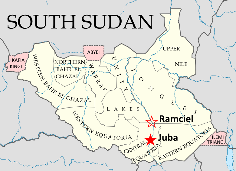
South Sudan’s states and disputed regions (pink), showing the current
capital (Juba) and the planned future capital (Ramciel). My own work,
Based on this map by NordNordWest/Wikipedia (license: CC-BY-SA).

South Sudan’s capital is currently located in the Juba, also its largest city, which is located on the White Nile river in the south of the country. However, there have long been proposals to move the capital to a more central location, and in September the government announced the official location of South Sudan’s next capital, a city which will be planned and built near the meeting point of the country’s three traditional provinces (now divided into a number of smaller states). The site is known as Ramciel, and is said to have been advocated by John Garang, southern Sudan’s leader from the civil war period, who died in a helicopter crash six years before the country achieved its official independence.

See Also: South Sudan Joins U.N.
Wikipedia: South Sudan

Libya Reunited Under Rebels

Country Name (official): Libya (English), Lībyā (Arabic)
News Category: Divided Countries
Summary: Libya’s civil war came to an end two weeks ago, as rebels under the National Transitional Council (NTC) completed their two-month campaign to flush out the last forces loyal to dictator Muammar Gaddafi. After taking the capital city of Tripoli in August, the NTC had already assumed Libya’s seat in the United Nations, the African Union, and the Arab League, with formal recognition from 100 U.N. member states. With the end of the war, the air-based foreign military intervention that helped bring victory to the rebels has also now come to a close.

The NTC’s last campaigns to reunite Libya. Gaddafi-held cities (green) and
rebel-held cities (black) as of 2 Sep. Rebel movements and capture dates
in red. My own work based on public domain map from Wikipedia (source).

Full Story
Libya’s participation in the “Arab Spring” movement happening across the Middle East and North Africa began as a series of protests in February, and quickly transformed into an armed uprising after national leader Muammar Gaddafi responded with violent crackdowns. Soon the country’s territory was divided between Gaddafi’s government and rebel forces under the National Transitional Council (NTC), with the latter dominating the eastern half of the country as well as the western mountains near Tripoli, the national capital. A near-stalemate held for about five months, as a U.N.-mandated no-fly zone and NATO-led bombing campaign kept Gaddafi’s forces at bay. Then, in late August, the rebels suddenly stormed into Tripoli, taking the national capital and many of the surrounding areas. The Gaddafi government only remained in control of a few scattered cities and desert outposts.

See Also: Political Geography Now: Libyan Rebels Take Capital

The NTC’s official flag of Libya (bottom) has replaced that
of Gaddafi (top). Public domain, from this Wikipedia page.

For two months following the takeover of Tripoli, the NTC mounted a campaign to drive out the last bastions of Gaddafi loyalist control and reunite the country under their own banner. The first area to fall was the southwestern Fezzan, a desert region with Sabha as its major city, in mid-to-late September. Then came Tripoli’s neighbor Bani Walid on 17 October, and finally Gaddafi’s hometown of Sirte three days later. As Sirte fell to the rebels, Gaddafi himself was finally captured, and soon died under mysterious circumstances. NTC Chair Mustafa Abdul Jalil declared the war officially over on 23 October. NATO’s enforcement and bombing mission ended one week later, following the U.N. Security Council’s withdrawal of its authorization for a no-fly zone and military protection of civilians. The rebel victory also brings an end to the dispute over the country’s flag (see illustration at left) and its official name, now just “Libya” rather than Gaddafi’s inventive “Great Socialist People’s Libyan Arab Jamahiriya.”

Wikipedia: 2011 Libyan Civil War

As the NTC rebels expanded their control over the country and Libyan diplomats abroad defected by the dozen, many countries around the world made the gesture of recognizing the NTC as the legitimate government of Libya. One hundred U.N. member states and four non-member states have declared their recognition of the new government, though the point is largely moot now that the NTC officially represents Libya in the United Nations itself. On 16 September, the U.N. General Assembly voted by a majority to hand over the country’s seat to the NTC, with 114 countries in favor and only 17 countries from Africa and Latin America voting against (a number of other delegations abstained or were absent). The African Union, within which Muammar Gaddafi was until recently a prominent figure, had declined to fully support the rebels during the war, but finally authorized the NTC to hold Libya’s seat in the organization on 20 October. Libya is also a member of the Arab League, which handed representation over to the NTC after the fall of Tripoli in August. Prior to that, Libya’s Arab League membership had been suspended in support of the rebels.

Countries officially recognizing the NTC during the war in dark blue, and countries officially opposing it in dark red. Libya in yellow. Countries in lighter colors unofficially acknowledged or opposed the NTC through diplomatic activities or votes in the U.N. General Assembly. Slightly modified from public domain Wikimedia map (source).

Wikipedia: International Recognition of the National Transitional Council

News Bits: October 2011

“News Bits” posts cover minor political geography events from the last few months. Although the news may be of great political relevance, these events haven’t (yet) affected major changes to the shapes, sovereignty, or political status of the world’s countries.

Yemen: Militias Take Territory From Islamists

Territory and areas of influence for rebels (blue) and Islamic
extremists (red) in Yemen. Map is my own work, starting
from this map by German Wikipedia user NordNordWest
(license: CC BY-SA). (Corrected November 20, 2011)

In Yemen’s ongoing political crisis (See: Yemen Fragments Under Uprising), some territory previously held by Islamist militants has fallen under the control of unsympathetic non-government forces, whose presence around the country seems to be expanding. The Islamists, who call themselves Ansar al-Sharia (“Partisans of Islamic Law”), have occupied the cities of Jaar, Zinjibar, and Shuqra in Abyan province for several months now, along with various smaller towns both in Abyan and in heighboring Shabwah. However, since July, many of the smaller towns have fallen into the hands of local militias, and the Yemeni government has gained ground in the Zinjibar area. Though the local militias are currently working alongside the government, it is unclear whether it may be only a temporary truce. Yemen’s opposition forces are composed of a mixture of local and kinship-based militias, army defectors, and pre-existing rebel groups, which sometimes work together but are increasingly clashing among themselves. The country’s third largest city, Taiz, is largely under the control of opposition forces, as are some parts of the capital, Sana’a. (More Yemen news on Political Geography Now)

Sudan No Longer Africa’s Largest Country
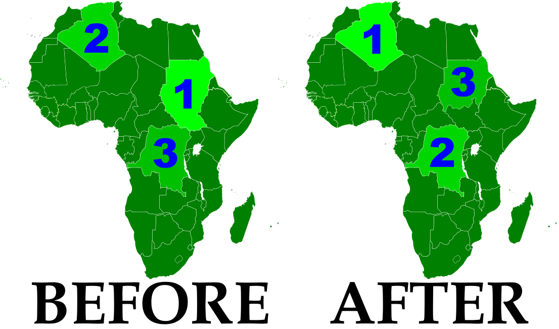
Now that the South Sudan has gained independence (See: New Country – South Sudan), the remainder of Sudan is no longer Africa’s largest country by area. Sudan’s one-time top spot was  followed by Algeria in second place and the Democratic Republic of the Congo in third. However, the secession of South Sudan  removed a substantial portion of Sudan’s territory, and the northern remainder of the country now ranks third in Africa – after Algeria and the DRC. South Sudan ranks 19th, out of a total of 54 U.N.-recognized countries in Africa. (Graphic my own work, based on this map by Wikipedia user Mangwanani. License: CC BY-SA)

Map showing most of the Cooch Behar
enclaves. By Dutch Wikipedia user
Jeroen (source). License: CC BY-SA

Wikipedia: List of African Countries and Territories

Indo-Bangladesh Treaty Defines Border, Trades Enclaves
A treaty signed last month between the governments of India and Bangladesh fully defines the border between the two countries, and provides for the trade of dozens of enclaves. The Indo-Bangladesh enclaves, also known as “chitmahals” or the “Cooch Behar enclaves” (after the district of India which most of them either belong to or are located inside), number well over 100, including patches of Indian territory within Bangladesh and patches of Bengladeshi territory within India. Their inhabitants have long suffered under abominable living conditions due to the fact that they have access neither to services from their own country (because of their isolation) nor to services from the country surrounding them (because they are not considered part of its territory). Under the new agreement, based on a 1974 deal that was never adopted, nearly all of the enclaves will be ceded to whichever country surrounds them, and inhabitants will have a choice of citizenship. The two parties also defined the border in several previously disputed or undemarcated areas. The treaty will not go into effect until it is ratified by both countries’ legislatures.

Location of Rastan within Syria. Based on this
map
by German Wikipedia user NordNordWest.
License: CC BY-SA

Syrian City Falls Briefly to Rebels
In Syria’s ongoing uprising, the city of Rastan fell under control of protester-friendly rebel forces for a few weeks last month, before ultimately being retaken by government troops. The crisis in Syria, seen as part of the so-called “Arab Spring” movement for democratic change in the Middle East, began with protests last January. By march it had escalated to widespread displays of defiance in the streets, to which the government responded by sending in tanks and soldiers. However, the resistance was mostly unarmed until army defectors began organizing against the military in September. The city of Rastan, one of several major protest centers, was taken over by anti-government forces, which were not driven out until October 1. So far there have been no more reports of Syrian cities falling under armed anti-government control, but protests and violent government crackdowns continue in full gear.

Libyan Rebels Take Capital

Country Name: Libya (English), Lībyā (Arabic)
Official Name (National Transitional Council): Libya, Libyan Republic
Official Name (Gaddafi Regime): Great Socialist People’s Libyan Arab Jamahariya (English), al-Jamāhīriyyah al-‘Arabiyyah al-Lībiyyah ash-Sha‘biyyah al-Ishtirākiyyah al-‘Uẓmá (Arabic)
News Category: Divided Countries
Summary: Libyan rebels last month took sudden control of the national capital of Tripoli and other cities, ending months of stalemate in the North African country’s civil war. Although the old government of Muammar Gaddafi maintains control of a few holdout cities, the rebel National Transitional Council is gaining increasing recognition internationally. The power transition is bringing with it changes to the country’s flag and official name.
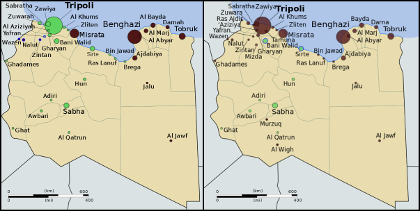
Control of Libya on June 1 (left) and September 2 (right). Gaddafi-held cities in green, rebel-held cities in
black. Blue represents ongoing struggle for control. Public domain maps from Wikimedia (source).


Full Story
Libya’s division between warring factions began in mid-February of this year, during the height of the “Arab Spring” protests happening across the Middle East and North Africa. Dictatorships in Tunisia and Egypt had recently fallen to popular protest movements, and many Libyans were fed up with their country’s erratic and sometimes brutal leader, Muammar Gaddafi. Protesters hit the streets, and when the government answered with violent crackdowns, the protesters fought back. Within days, several cities in eastern Libya had fallen to the rebels, who by the end of the month controlled most of the country’s east and some parts of the west. A government counteroffensive stalled after intervention by NATO, and the country was effectively divided in two, with rebel-held territories governed by the National Transitional Council (NTC) and the remainder under Gaddafi’s control.

Link: Interactive map of the Libyan uprising (February-April) – The New York Times

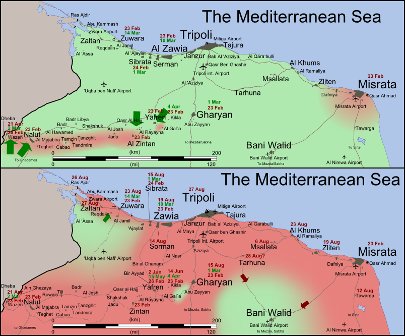
Control of northwestern Libya on June 1 (top) and September 2 (bottom).
Gaddafi-held territory is shown in light green; rebel-held territory is
shown in dark pink. Map by Wikimedia user Rafy (source; CC BY-SA).

The civil war in Libya remained in apparent stalemate for the next five months, with the two sides trading small amounts of territory but not making any major gains. All that changed in late August, when rebel forces suddenly began taking more western towns, then quickly stormed into the capital city of Tripoli, taking control and securing Gaddafi’s headquarters. More rebel gains followed on the eastern front. Gaddafi himself, along with much of his family, escaped from Tripoli and has not yet been located. Forces loyal to him remain in control of the cities of Sabha, Bani Walid, and Sirte – the last of which is Gaddafi’s hometown. Meanwhile, the NTC is in the process of moving its headquarters from its unnofficial capital in Benghazi to the official capital in Tripoli, and many Libyan embassies around the world have switched their allegiance from Gaddafi to the NTC. With international recognition for the NTC growing, the new government seems likely to soon fully replace Gaddafi as representative of the Libyan people on the international stage.

Wikipedia: 2011 Libyan Civil War

The flag of Libya under the Gaddafi regime (top) and under
the NTC (bottom). Public domain, from this Wikipedia page.

Changing Flag and Country Name
As with most revolutions, the rebellion in Libya has brought with it a changing identity. The rebel National Transitional Council, and the movement that spawned it, have been quick to discard any symbols of the Gaddafi regime. One of the most prominent of these symbols is the national flag. For decades, Gaddafi’s Libya has been known by it’s unique flag design: a plain, unmarked green rectangle. The rebel movement, on the other hand, has mostly used the flag of the Kingdom of Libya which Gaddafi overthrew, composed of red, black, and green stripes, with the crescent and star of the Ottoman Empire in white at the center. This was declared the official flag by the NTC, and is now flown at the United Nations and most of Libya’s embassies abroad.

Wikipedia: Flag of Libya

Another eccentricity of Gaddafi’s Libya was the country’s full official name, translated into English as the Great Socialist People’s Libyan Arab Jamahiriya. “Jamahiriya” is a word invented by Gaddafi for what he believed to be a unique and superior form of government, supposedly based on direct rule by the people. The word is a combination of the Arabic words jumhūriyya (“republic”) and jamāhīr (“the masses”). The NTC, again making a point of disassociating itself from Gaddafi, has preferred to simply refer to the country as “Libya”, occasionally using the term “Libyan Republic”.

International Recognition of the NTC
As the rebels and the National Transitional Council consolidate their control of the country, more and more countries are recognizing the NTC as the legitimate government of Libya. For most countries, which already recognize Libya as an independent country, this is a special diplomatic gesture of support for the rebels; or now that the NTC controls most of the country, a gesture of acceptance of the current state of affairs. The number of states recognizing the NTC has risen drastically, from only 11 when I reported on the situation two months ago, to a current total of 78 U.N. member states and two non-U.N. members (Palestine and Kosovo). Several more U.N. members have established diplomatic relations with the new Libyan government without making formal declarations of recognition. However, at least four countries – Venezuela, Zimbabwe, Ecuador, and Nicaragua – have stated their refusal to recognize the change in government.

Countries officially recognizing the National Transitional Council in dark blue; countries maintaining diplomatic relations with the NTC without official recognition in light blue; countries refusing to recognize the NTC in red;
Libya in yellow. Slightly modified from public domain Wikimedia map (source).

South Sudan Joins African Union

Country Name: South Sudan
Official Name: Republic of South Sudan
News Categories: Intergovernmental Organizations
Summary: New U.N. member South Sudan has been admitted into the African Union, the continent’s highest level intergovernmental organization. Formal recognition from individual countries is still continuing.

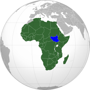
South Sudan (blue) in the A.U. (green). Modified from
this map by Wikimedia user Heraldry (CC BY-SA).

See Also: New Country: South Sudan

Full Story
Less than three weeks after declaring independence, the new Republic of South Sudan has been admitted into the African Union (A.U.). The A.U., which represents all of Africa’s countries except for Morocco, voted with a majority in favor of allowing South Sudan’s entrance into the organization. Membership will allow the new state to participate fully in the community of African nations, while the A.U. is soon to begin mediating talks over the remaining disputes between South Sudan and Sudan, the country from which it seceded this month. South Sudan is the 54th member of the African Union, and the first new member since Eritrea joined in 1993.

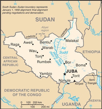
Map of South Sudan from the CIA
World Factbook
(public domain).

See Also: South Sudan Joins U.N.

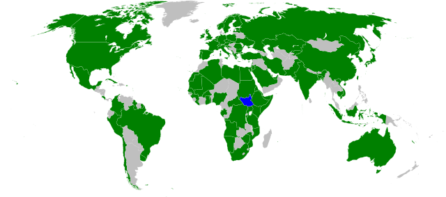
In addition to A.U. and U.N. membership, South Sudan has continued to receive recognition from individual countries. Official statements of recognition for the new country have now been released by 97 U.N. members and six other sovereign states. Ninety-five U.N. member countries have not yet formally recognized South Sudan, but none have opposed it’s independence – an indication that they all intend to accept it as the world’s newest sovereign state.

Countries which have officially stated their recognition of South Sudan’s sovereignty (green). South Sudan in blue. Modified from this Wikimedia map (public domain).

Wikipedia: South Sudan, Foreign Relations of South Sudan, African Union

South Sudan Joins U.N.

Country Name: South Sudan
Official Name: Republic of South Sudan
News Categories: Intergovernmental Organizations, New Countries
Summary: The newly independent Republic of South Sudan was admitted into the United Nations (U.N.) last week, effectively giving it full status as a nation-state in the international community. Diplomatic recognition from individual countries is still continuing, though the process is now little more than a formality.

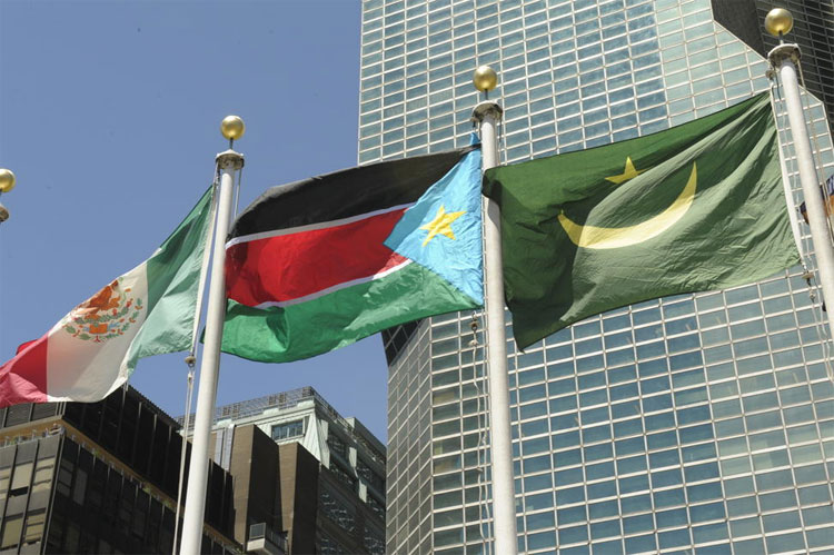
U.N. headquarters in New York fly South Sudan’s flag
after accepting the new state as a member. U.N. photo
used in accordance with official usage policy (source).

See Also: New Country: South Sudan

Full Story
Just five days after officially declaring independence, the new Republic of South Sudan has been welcomed as the 193rd member of the United Nations. The small African country received membership through a unanimous vote of the U.N. General Assembly on July 14th, following a recommendation from the U.N. Security Council the day before, which was also unanimous. Membership will allow the new state to participate fully in the U.N. and all of its associated organizations, and gives it the legitimacy required for a guaranteed place on world maps and lists of the world’s countries.

See Also: How many countries are there in the world? (UPDATED)

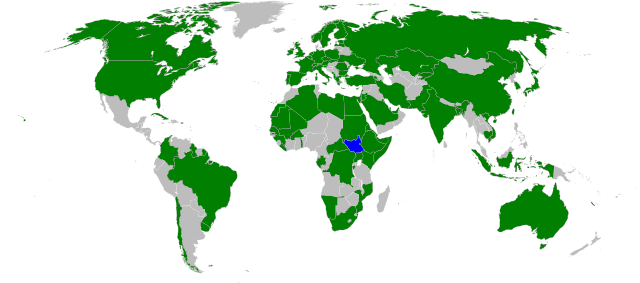
In addition to U.N. membership, South Sudan has continued to receive recognition from individual countries. Approximately 88 U.N. members and six other sovereign states have now made official statements recognizing the new country. Although that still leaves 104 U.N. member countries which have not yet formally recognized South Sudan, the unanimous vote of the U.N. General Assembly suggests that all members do intend to acknowledge its legitimacy, whether by official decree or not. No state has indicated any intention to oppose the new state’s independence.

Countries which have officially stated their recognition of South Sudan’s sovereignty (green). South Sudan in blue. Modified from this Wikimedia map (public domain).

Wikipedia: South Sudan, Foreign Relations of South Sudan, United Nations