Nigeria Conflict Map: Assault on Boko Haram

There are newer versions of this map available. To see them, view all Nigeria updates.

Nigeria’s Boko Haram rebels have been active for some years, but it’s only in recent months that they’ve become known to control territory in the country’s far northeast. Now they’re facing a full-on assault from the government after the president declared a state of emergency. Read on for details!
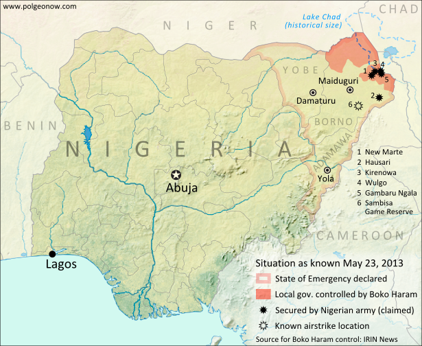
Map of Boko Haram control in northeastern Nigeria, and progress made by the government after declaring a state of emergency and launching a military campaign against the rebels in May 2013.
Boko Haram control and the government intervention in Nigeria’s northeast. Map by Evan Centanni.

Boko Haram Control in Borno State
Nigeria, Africa’s most populous country, has faced regular attacks from the rebels of Boko Haram over the past several years. Operating in the country’s predominantly Muslim north, the fighters claim to seek a purer Islamic society uninfluenced by Western ideas and teaching. While the group’s area of operations stretches across much of northern Nigeria, spilling over into northern Cameroon, until recently Boko Haram was not known for controlling any specific territory.

However, over the past few months there has been more and more talk of areas in Nigeria’s far northeastern Borno State falling under full control of Boko Haram, especially in the area of Lake Chad and the remote border with Cameroon. A report from the U.N.’s IRIN humanitarian news agency lists eight local government areas (similar to counties) in Borno which it says Boko Haram has taken over since January of this year.

Background: What is Boko Haram? A summary and detailed history
Flag of NigeriaCountry Name:  
• Nigeria*
Official Name:  
• Federal Republic of Nigeria*
Capital: Abuja
*There are hundreds of languages spoken in Nigeria, but only English is official.

State of Emergency
Last week, Nigerian President Goodluck Jonathan brought the situation to the world’s attention, announcing that the Boko Haram rebels had wrested control of some areas on the country, and declaring a state of emergency in Nigeria’s three northeasternmost states of Borno, Yobe, and Adamawa. The next day, troops flooded into the region, and a government offensive against the rebels began.

Though details are sparse, fighting since then seems to have focused largely on raiding Boko Haram camps in the central and southern areas of Borno state, leaving the other two states, as well as Borno’s capital, relatively calm. Political Geography Now has not discovered any reports of fighting so far along Borno’s northern border with Niger, despite that being an area claimed by IRIN to be under Boko Haram control.

There have been airstrikes against Boko Haram at various locations which have not been disclosed, though one is reported to be the Sambisa Game Reserve south of Maiduguri, part of a stretch of forest where the rebels are known to have hideouts for avoiding the Nigerian army. By May 17th, government forces had reportedly secured a border crossing with Cameroon at Gambaru Ngala, and this Monday the Nigerian government claimed to have recaptured the towns of New Marte, Hausari, Kirenowa, Wulgo, and Chikun Ngulalo from Boko Haram.*

(*Chikun Ngulalo is not shown on the map above, as we have been unable to locate its position.)

Stay tuned for more updates as new information becomes available. Keep up by checking Political Geography Now homepage, or use the Nigeria filter to view only stories about this country.

Related Articles:
Graphic of the Nigerian flag is in the public domain (source).
Mali Conflict Map: Hardline Rebels on the Run, Separatists Rebounding (May 2013)

There are newer versions of this map available. To see them, view all Mali maps.  

This is an update within our Mali conflict map series – for the original story, see Mali Map: Islamist Control & French Intervention.

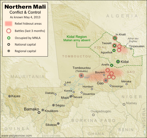
Updated map of fighting and territorial control in Mali during the 2013 French and African intervention against Islamist rebel groups MUJAO, Ansar Dine, and Al Qaeda in the Islamic Maghreb (AQIM). Reflects the situation as of May 4, 2013, including areas occupied by Tuareg rebels of the National Movement for the Liberation of Azawad (MNLA).
Updated map of territorial control and fighting in Mali, as of May 4, 2013. Map by Evan Centanni, modified from Wikimedia map by Orionist, using images by Carport and NordNordWest (source). License: CC BY-SA.

Towns Cleared of Islamist Rebels
Since our last Mali update in February, the country’s religious extremist rebel groups have continued their retreat from the northern cities that they controlled for half a year. The military intervention by France and Mali’s neighbors has somewhat reunited the country, though with some important exceptions.

In Mali’s far northeast, French and Chadian forces have driven Ansar Dine and Al Qaeda in the Islamic Maghreb (AQIM) out of the important towns of Aguelhok and Tessalit, afterwards seeing heavy combat in the nearby mountains of the Adrar des Ifoghas, where Chad claims to have killed two key regional Al Qaeda leaders. Though many rebels are said to have fled the country, some are still holed up deep in the mountains, and have launched terrorist attacks on the regional capital of Kidal.

More information: Regular situation reports from the French army (in French)

Northern Mali’s biggest city, Gao, was secured by French forces early in the intervention, and is now patrolled by troops from Mali and other African countries. However, the Al Qaeda-offshoot rebels of the Movement for Unity and Jihad in West Africa (MUJAO), who ruled the city for months, have continued their resistance, initiating two major battles in Gao during February, and another in March. Timbuktu has faced similar attacks, which have been variously attributed to either MUJAO or AQIM.

Flag of MaliCountry Name:  
• Mali (English, French, Bambara)
Official Name:  
• Republic of Mali (English)
• République du Mali (French) 
• Mali ka Fasojamana (Bambara)
Capital: Bamako

MUJAO fighters are now based in the villages and countryside surrounding Gao, especially just across the River Niger and in the valleys to the northeast, where French soldiers have been involved in lethal confrontations with the militants. The stretch of the River Niger between Gao and Timbuktu has also seen MUJAO activity, but at least one major town along the route, Bourem, has been secured by the allied forces.

Photos: Mali Conflict Enters New Phase (The Atlantic)

Kidal, Azawad, and the MNLA
The National Movement for the Liberation of Azawad (MNLA), a secular rebel organization made up mostly of people from the Tuareg ethnic group, has sprung back to life in Mali’s far northeast. It now occupies most of the Kidal region, including the capital and key towns, cooperating with the French and Chadian armies but forbidding Malian troops from entering.

The group, which initiated the rebellion in northern Mali last year – declaring an independent country called “Azawad” before being pushed out by Ansar Dine and MUJAO – now seeks again to negotiate with the Malian government. It has ceased its explicit calls for independence, even saying it “recognizes the borders” of Mali, though it has since begun issuing official “Republic of Azawad” documents to drivers passing through Mali’s far northeast.

This second rise of the MNLA was made possible by concerns that Malian soldiers were abusing, and in some cases murdering, Tuareg civilians in the cities they had retaken. Kidal, unlike Gao and Timbuktu, actually has a Tuareg majority, and the MNLA is relatively popular there. After the extremist Ansar Dine rebels fled from Kidal ahead of the French advance, the MNLA welcomed the foreign troops, cooperating with the soldiers from France and Chad. The Malian army, apparently sensing it’s not welcome, has mostly not entered the region.

The MNLA now operates a checkpoint in Anefis, on the border of Kidal and Gao regions, and has defended itself against other rebel groups in the surrounding desert as well as in the town of In Khalil on the border of Mali and Algeria. In February, the MNLA also claimed control of Menaka in Gao region, but the town is now known to be under the control of African troops from neighboring Niger.

Northern Mali: Looking Forward
The future is not at all certain for Mali’s north, with Islamist militants still active and the MNLA calling for greater autonomy against the wishes of the Malian government. Deepening the uncertainty, France and Chad, by far the two strongest armies currently in Mali, are both beginning to withdraw their forces, not wanting to become stuck in an ongoing guerrilla war. However, there’s still hope for Mali not to descend back into chaos; the U.N. security council has authorized a peacekeeping mission to take over starting from July, which will work under the name Multidimensional Integrated Stabilization Mission in Mali (MINUSMA).

Related Articles:

Central African Republic: Map of Rebel Advance to Capital

Graphic of Malian flag is in the public domain (source).
Niger and Burkina Faso Resolve Territorial Dispute

Update: In May 2015, Niger and Burkina Faso formally agreed to implement this ICJ ruling, with the practical aspects of exchanging territories to be completed by the end of the following year.

Map of the disputed territory between Niger and Burkina Faso, which was divided between the two countries in an April 2013 ruling by the International Court of Justice
Map by Evan Centanni. Sources: ICJ, Natural Earth. Africa inset based on this map by TUBS/Wikimedia Commons (CC BY-SA).

By Evan Centanni
 
Border Dispute Settled
Last week, a territorial dispute between the West African countries of Niger and Burkina Faso was resolved peacefully with a ruling from the International Court of Justice (ICJ). Both countries’ governments agreed to respect the court’s ruling on where their border should lie, a question which had persisted ever since they both achieved independence in 1960.

In the ruling, the court drew an official border based on a careful analysis of a 1927 document establishing the pre-independence boundary between the two former French colonies, also turning to a 1960 French map which both countries had agreed to use as a secondary reference. The new border splits the disputed area between Burkina Faso and Niger, and will help put an end to confusion regarding policing and tax collection in the border area.

The ICJ, or World Court, is a part of the U.N., and is tasked mainly with arbitrating disagreements between U.N. member countries. It should not be confused with the International Criminal Court (ICC), which prosecutes individuals for war crimes. Niger and Burkina Faso had agreed by treaty to send the case of their disputed border to the ICJ for settlement, and both have expressed satisfaction with the result.

Further Reading: Full Text of ICJ ruling on Burkina Faso/Niger Frontier Dispute (PDF)

Unclaimed Land
An interesting curiosity noted in this case is that Burkina Faso and Niger’s respective border claims left a small strip of land claimed by neither country. The area, stretching between two locations referred to as the Tong-Tong and Tao astronomic markers, was left unclaimed because Burkina Faso considered the border to be a straight line running between the two markers, while Niger also respected a third marker placed a bit east of the line.

The third marker had originally been intended to lie exactly along the line between Tong-Tong and Tao, but was placed inaccurately. It is not entirely clear why Niger would choose to define its border in a way that would give it less territory than did Burkina Faso’s definition, but in any case the court discounted the third marker, giving the strip of land to Niger in the final ruling. A more famous (and still outstanding) case of a territory not claimed by any country is the Bir Tawil “triangle” between Egypt and Sudan.

Related Articles:

North Kosovo Status Changing after Serbia Deal

Central African Republic: Map of Rebel Advance to Capital (March 2013)

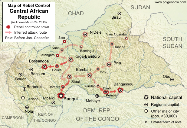
Last January, rebels in the Central African Republic agreed to a ceasefire with the government, after taking over much of the country. Now, despite the formation of a unity government, the ceasefire has broken down and the rebels are once again advancing on the capital and other towns. Read on for a summary of events. Update (March 24, 2013): The Séléka rebel coalition has now taken the national capital, Bangui.

Map of 2012-2013 rebellion in the Central African Republic, showing current rebel control as of March 24, 2013, from the breakdown of the ceasefire up to the capture of the national capital city, Bangui
Advance of Séléka rebels in the Central African Republic, highlighting attacks occurring since the Jan. 11 ceasefire. Map fact-checked and expanded by Evan Centanni from this map by Wikimedia user Keitsist. License: CC BY-SA

Original Article: Central African Republic – Map of Rebel Control

Ceasefire Violations
After reaching a ceasefire with the government on January 11th, the Central African Republic’s Séléka rebel coalition began integration into a new unity government, with several rebel leaders receiving prominent positions in President François Bozizé’s cabinet. However, the violence did not end completely.

Bands of rebels attacked the southern towns of Dimbi and Kémbé less than two weeks after the ceasefire, and occupied the southern city of Mobaye for two weeks in February before finally withdrawing on the 20th. Another group attacked and took over the northern town of Sido on March 1st. By March 12th, the rebels in the south advanced once again to seize regional capital Bangassou.

Flag of the Central African RepublicCountry Name:  
• Central African Republic (English)
• Centrafrique (French)
• Bêafrîka (Sango)
Official Name:  
• Central African Republic (English)
• République centrafricaine (French)
•Ködörösêse tî Bêafrîka (Sango)
Capital: Bangui

Ceasefire Breakdown
On March 18th, it was reported that the Séléka rebels had “detained” their five ministers from the Central African Republic unity government, and issued a 72-hour deadline for their demands to be met. Sure enough, on March 20th a rebel spokesperson announced that the ceasefire had come to an end.

In the northwest, rebels claimed to capture Bouca and Batangafo soon afterwards (the latter had already been reported taken once in December). In the south, they continued onward toward the capital city of Bangui, seizing the town of Damara despite the presence of a multinational African peacekeeping force, which did not fire a shot. Meanwhile, they had captured yet another regional capital, Bossangoa, in the northwest.

Capital Seized by Rebels (update)
Today, March 24th, the Séléka coalition rebels reportedly took control of the national capital, Bangui, with President Bozizé fleeing across the border into the Democratic Republic of the Congo. It still remains unclear what will happen next. Stay tuned to Political Geography Now for further updates!

Graphic of the flag of the Central African Republic is in the public domain (source).

Libya Changes Official Name

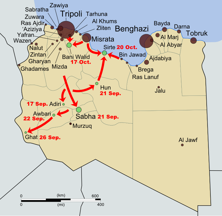
Map of rebel campaigns during the last stage of Libya's 2011 civil war
Map of the last stage of Libya’s 2011 civil war (click to see full map and original article). Map by Evan Centanni, based on public domain map from Wikipedia (source).

State of Libya
Last month, the North African country of Libya changed its official long-form name to “State of Libya” (Arabic: Dawlat Libya). This comes as part of Libya’s governmental transition following its 2011 civil war, in which a rebel coalition defeated the regime of dictator Muammar Gaddafi.

Over the last year, the country’s formal name had not been clearly defined, with the country referred to in most documents simply as “Libya”. The rebel National Transitional Council had only made a point of ceasing to use the Gaddafi-era name.

During the last decades of Gaddafi’s reign, the country was known in long form as the “Great Socialist People’s Libyan Arab Jamahiriya”. The word “jamahiriya” was coined by Gaddafi by combining the Arabic words for “republic” (jumhuriya) and “the masses” (jamahir).

The new name, “State of Libya”, voted in by the country’s General National Congress on January 8th, is intended to be temporary pending the approval of a new national constitution. However, it is entirely possible that the constitution, once drafted, could also choose to use the same name.

This marks the third year in a row that a country has changed its official name during the year’s first two months: last January, the Republic of Hungary changed its name to just “Hungary”, and in February 2011, the Republic of the Fiji Islands shortened its name to “Republic of Fiji”.

Central African Republic Rebels Join Government (February 2013)

Map of rebel control in the Central African Republic, updated for the reported occupation of Dimbi and Kembe towns after the January 2013 ceasefire
Updated Central African Republic rebel control map. Fact-checked and modified by Evan Centanni from this map by Wikimedia user Keitsist. License: CC BY-SA

Unity Government Announced
After taking control of much of the country in December and January, rebels in the Central African Republic have been given a place in a new unity government that was announced last Sunday. The formation of this government will officially end the country’s period of division between the old administration and the “Séléka” rebel coalition.

However, it remains to be seen whether the Central African Republic will truly be reunited in terms of the facts on the ground. Insecurity and chaos has continued at reduced levels since the ceasefire of January 11, with one band of rebels even attacking two more towns during the interim (see updated map at right).

For the full story of Séléka’s lighting-fast campaign to control the country, see our previous article Central African Republic: Map of Rebel Control.

Updated Map: Central African Republic – Map of Rebel Control (March 2013)

Mali Conflict Map: French Take Kidal, Other Towns (February 2013)

There are newer versions of this map available. To see them, view all Mali maps.  

This is an update of our Mali conflict map – for the original story, see Mali Map: Islamist Control & French Intervention.

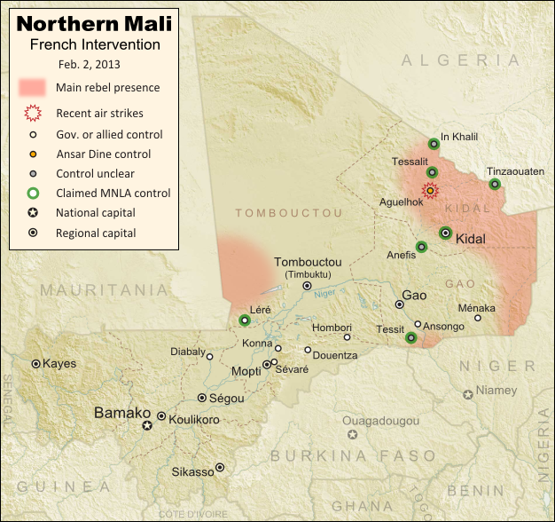
Updated map of fighting and territorial control in Mali during the January-February 2013 French intervention against the Islamist extremist rebel groups Ansar Dine and MUJAO. Reflects the situation as of February 2, when Kidal and other towns have been captured by French and African forces.
Updated map of territorial control and airstrikes in Mali, as of Feb. 2, 2013. Map by Evan Centanni, modified from Wikimedia map by Orionist, using images by Carport and NordNordWest (source). License: CC BY-SA.

French Troops Secure Kidal
After taking the two largest cities in Mali’s north over the last week, the French military by Thursday had also secured Kidal, the last of the area’s three major regional centers. The religious extremist rebels of Ansar Dine had apparently already fled the city, which was instead occupied by two moderate rebel organizations, the MIA and the MNLA, the latter of which originally took over the north last spring before being driven out by religious extremist groups.

The MNLA rebels, who were originally a Tuareg-led separatist movement (and even declared an independent country in their territory), have reemerged since the French intervention began, with an apparent willingness to negotiate for limited autonomy within Mali. If fact, they did not resist the French takeover of Kidal, saying they only refuse occupation by the Malian army itself, which they claim has long abused the Tuareg and Arab people of the far north. They also claimed control of a number of towns in the region this week, though journalists have not been able to verify these assertions.

Flag of MaliCountry Name:  
• Mali (English, French, Bambara)
Official Name:  
• Republic of Mali (English)
• République du Mali (French) 
• Mali ka Fasojamana (Bambara)
Capital: Bamako

Meanwhile, two other major towns near Gao have also fallen out of rebel hands. Ansongo was taken on Tuesday by forces from Niger and Mali, while Ménaka was occupied by allied soldiers from Chad. The Chadian contingent makes up nearly half of the African foreign supporting force in Mali, and unlike the others is not a member of the West African regional bloc ECOWAS.

With the capture of all three major northern cities, and reports that most of the Niger River region has also been secured, the first phase of the intervention in Mali is coming to an end. The victorious French and Malian presidents made a celebratory visit to Timbuktu on Saturday, declaring that French soldiers would remain in the country only long enough for African forces to take over the peacekeeping mission.

The extremist rebels have apparently fled into the desert, with Ansar Dine (or what’s left of it after its split with the MIA) believed to be hiding out in the mountains north of Kidal. The only town known to be under their control is Aguelhok, which was targeted by French airstrikes in recent days.

Besides the shrinking strongholds of Ansar Dine, several border areas appear to be under the influence of the MNLA rebels, though as mentioned before, they have not opposed the foreign intervention so far. MUJAO, the other major extremist group which had controlled towns in northern Mali, is apparently nowhere to be seen (for the moment anyway).

Original Story: Mali Map: Islamist Control & French Intervention

Further Reading: 
Islamists’ Harsh Rule Awakened Ethnic Tensions in Timbuktu
Niger agrees to host Mali-bound U.S. spy drones
Reuters Slideshow – Timbuktu Retaken

Additional Source for Map: France24 map – War in Northern Mali

Graphic of Malian flag is in the public domain (source).
Mali Conflict Map: Gao and Timbuktu Retaken (January 2013)

There are newer versions of this map available. To see them, view all Mali maps.   

This is an update of our Mali conflict map – for the original story, see Mali Map: Islamist Control & French Intervention.

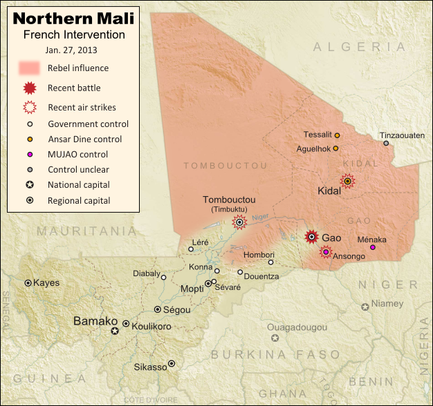
Updated map of fighting and territorial control in Mali during the January 2013 French intervention against the Islamist forces of Ansar Dine and MUJAO. Reflects the Jan. 26-27 recapture of major northern cities Gao and Timbuktu by French and Malian forces.
Updated map of territorial control and fighting in Mali, as of Jan. 27, 2013. Map by Evan Centanni, modified from Wikimedia map by Orionist, using images by Carport and NordNordWest (source). License: CC BY-SA.

French-Malian troops capture two major northern cities
Events have proceeded quickly in Mali’s ongoing war since the France’s military intervention against radical Islamist rebels began just over two weeks ago. This weekend, French and Malian troops recaptured Gao and Timbuktu, two of the three major towns seized by separatist rebels last spring and taken over by radical right-wing militias a few months later.

After taking back most of the country’s central region earlier this week (See: Mali Map Update 2: Douentza Secured by Government), the allied French-Malian forces proceeded northeast from Diabaly and Douentza. On Friday, they took the town of Hombori on the road to Gao, even as Al Qaeda linked MUJAO rebels destroyed a bridge near the border with Niger in order to obstruct a looming invasion by Nigerien and Chadian troops.

Flag of MaliCountry Name:  
• Mali (English, French, Bambara)
Official Name:  
• Republic of Mali (English)
• République du Mali (French) 
• Mali ka Fasojamana (Bambara)
Capital: Bamako

On Saturday, the French and Malian armies seized Gao itself, where they seem to have encountered a limited amount of resistance from the rebels of MUJAO. Many of the militants had already fled the major cities after weeks of French airstrikes against their positions, and on Sunday the allied troops swept quickly through Léré and all the way to Timbuktu, where they are reportedly now establishing control.

Also in the past week, a major faction of the rebel group Ansar Dine defected, forming a new organization called the Islamic Movement for the Azawad. The new faction, dominated by Malian Tuareg people, claims to renounce Islamic extremism, instead saying they want to negotiate peacefully for increased autonomy in the country’s north.

Meanwhile, the French and Malian armies are receiving increasing support from other countries. The U.S., though not directly involved in the conflict, has been providing logistical support to the French military. And several days ago, troops from the neighboring country of Burkina Faso became the first foreign African forces to be deployed alongside the Malian and French contingents (though they still aren’t on the front lines).

On a darker note, accusations have spread of ethnically-motivated murders of Tuareg and Arab civilians by the Malian military (the northern rebels are mostly Tuareg and Arab people). This comes amid the mysterious barring of foreign journalists from towns occupied by the Malian and French forces. Officials have denied any knowledge of such killings, but human rights organizations have been increasingly raising alarms over the alleged abuse.

Original Story: Mali Map: Islamist Control & French Intervention

Recommended Reading: In Mali, Diabaly residents helped repel Islamist militants

Graphic of Malian flag is in the public domain (source).

Mali Conflict Map: Douentza Secured by Government (January 2013)

There are newer versions of this map available. To see them, view all Mali maps.   

This is an update of last week’s Mali conflict map – for the full story, see Mali Map: Islamist Control & French Intervention.

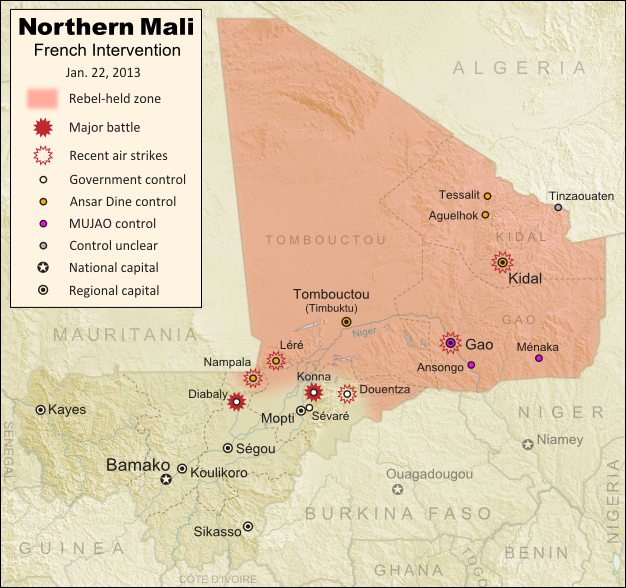
Updated map of fighting and territorial control in Mali during the January 2013 French intervention against the Islamist forces of Ansar Dine and MUJAO. Reflects the Jan. 21 recapture of central town Douentza by French and Malian forces.
Updated map of territorial control and fighting in Mali, as of Jan. 22, 2013. Map by Evan Centanni, modified from Wikimedia map by Orionist, using images by Carport and NordNordWest (source). License: CC BY-SA.

Key Central Town under French-Malian control
The ongoing French-led war against right-wing Islamic insurgents in northern Mali has achieved another victory. Douentza, probably the most important of the central Malian towns formerly held by the rebels, has now been secured by government and French forces. The allied troops reportedly found that the rebels had already left ahead of them, presumably fleeing the French airstrikes that targeted the town over the last week.

Douentza’s status had been a matter of uncertainty for some time, starting with apparently false claims of its capture by the Malian army on the eve of the French intervention. It had been held by the Movement for Unity and Jihad in West Africa (MUJAO), the more extreme of the two main rebel groups controlling territory in northern Mali (and the more closely connected to Al Qaeda).

The capture of Diabaly town has also been fully confirmed now, after a few days of confusion. It had been reported that there was fighting on the ground between French and rebel forces, but residents of the town say it was mainly airstrikes that drove the militants out.

Meanwhile, forces from both France neighboring African countries have continued to arrive in Mali to fight the rebels. French troops in the country now number over 2,000, while African troops from Nigeria, Togo, Benin, Niger, and Chad currently total about 1,000. Chadian and Nigerien troops are also amassing in Niger near the Malian border, from where they may open up a new front by crossing the border to take Gao, the region’s largest city and currently the headquarters of MUJAO.

Original Story: Mali Map: Islamist Control & French Intervention

Recommended Reading: Behind Mali’s conflict: myths, realities & unknowns (commentary from an expert in Mali)

Mali Conflict Map: Hardline Rebels Lose Two Towns (January 2013)

There are newer versions of this map available. To see them, view all Mali maps.   

This is an update of yesterday’s Mali conflict map – for the full story, see Mali Map: Islamist Control & French Intervention.

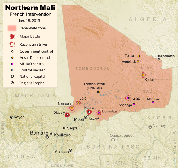
Updated map of fighting and territorial control in Mali during the January 2013 French intervention against the Islamist forces of Ansar Dine and MUJAO. Reflects the Jan. 18 recapture of Konna and Diabaly towns by French and Malian forces.
Updated map of territorial control and fighting in Mali, as of Jan. 18, 2013. Map by Evan Centanni, modified from Wikimedia map by Orionist, using images by Carport and NordNordWest (source). License: CC BY-SA.

Rebels Lose 2 Towns to French-Malian Forces

The French intervention in Mali has finally resulted in territorial gains for the government, after the two central towns of Konna and Diabaly were reportedly retaken by French and Malian troops today. Mali had incorrectly claimed the recapture of Konna earlier this week, and Diabaly was actually seized by the Islamic extremist rebels after French forces arrived. Local sources have now confirmed both towns to be under government control.

Also today, troops from a Nigerian-led West African force finally began arriving in the country (though they have not yet joined in the combat). Meanwhile, a hostage crisis continued into its third day in neighboring Algeria, where militants closely linked to Al Qaeda have taken over a natural gas field and captured its crew of international workers. By some accounts the militants have demanded an end to the French intervention in Mali, though the location of the gas field is far from Mali’s borders, and they are believed to have attacked from within Algeria.

Full Story: Mali Map: Islamist Control & French Intervention