South Sudan Rebellion: Map Update 2 (Premium Content)

Map of rebel control in South Sudan's ongoing rebellion, updated to Jan. 16, 2014

Download PDF
buy

(Subscribe via Paypal)

Both peace talks and fighting continue nearly two weeks after our last South Sudan update. In the meantime, there have been several changes to rebel control. The newly updated premium map and report reflect those events, as well as newly available information about other localities. Buy now (US$2.99).

Premium article includes:

  • Exclusive updated map of rebel control in South Sudan’s ongoing uprising (current as of January 16, 2014)
  • A number of new localities have been added to the map since last time
  • Report chronicling changes to territorial control since the previous map, with links to sources

Members click here to proceed to article and map

Not a member yet? Subscribe Now!

South Sudan: Rebel Control Map Update (Premium Content)

There are newer versions of this map available. To see the full list of updates, view all South Sudan articles

Map of rebel control in South Sudan's 2013-2014 political crisis, updated to Jan. 3, 2014

Download PDF
buy

(Subscribe via Paypal)

Since our first map report on rebel control in South Sudan’s political crisis, the situation has continued to develop quickly, with several cities and towns changing hands. PolGeoNow now presents an updated map and report exclusively available as premium content for purchase and to our subscribers. Buy now for only US$2.99!

Premium article includes:

  • Exclusive updated map of rebel control in South Sudan’s ongoing uprising 
  • Report chronicling changes since the previous map, with links to sources

Members click here to proceed to article and map

Not a member yet? Subscribe Now!

South Sudan Crisis: Rebel Control Map (Premium Content)

There are newer versions of this map available. To see the full list of updates, view all South Sudan articles

Report and map of rebel control in South Sudan's December 2013 political crisis; includes indications of control by state and city, including Juba, Bor, Bentiu, Malakal, and more

Download PDF
buy

After a sudden outbreak of political violence last week, the military of South Sudan has fragmented into two competing factions, with rebellious defectors capturing a large swath of the world’s newest country. PolGeoNow now presents the first map of rebel control in South Sudan’s ongoing crisis, an exclusive for premium subscribers and purchasers.

Premium article includes:

  • Exclusive, up-to-date map of rebel control by state and city in South Sudan’s ongoing uprising
  • Outline of the course of events so far, including the captures of three state capitals by rebel forces
  • Brief description of the causes and humanitarian consequences of the current conflict

Members click here to proceed to article and map

Not a member yet? Subscribe Now!

DR Congo War: The History of M23 Control (Map)

[Editor’s note: This map article was published in late 2013, and was originally intended to be the first piece in PolGeoNow’s conflict map subscription service. Subscriber coverage has since refocused on other conflicts, and we’re now making this piece free for all readers.]

From 2012 to 2013, the M23 rebels became the Democratic Republic of the Congo’s most powerful rebel group in recent history, establishing military control over a major city in country’s east. You may have heard how M23 was defeated suddenly in late 2013, but do you know what territory they controlled while they were active? Learn more with this exclusive map of M23’s territorial possessions over time, as well as a primer on the group’s short history and ultimate defeat.

Historical M23 Control Map: Map of territory controlled by the March 23 Movement (M23) rebels in the Democratic Republic of the Congo, both at their height in late 2012 and during their retreat in 2013. Also file under: What happened to M23?
Map by Evan Centanni (all rights reserved).

Congo’s War with M23

The Democratic Republic of the Congo – formerly known as Zaire – has been at war for decades. After serving as the stage for a regional conflict partly sparked by the Rwandan Genocide in the mid-1990s, as well as a follow-up war spanning officially from 1998 to 2003, the eastern DRC has become the stomping ground of dozens of rebel groups with often-shifting allegiances.

The March 23 Movement, better known as M23, only appeared in May of 2012. However, it quickly became the most prominent of the many rebel forces operating in the region, carving out its own area of territorial control and proving a match for the Congolese army. In late 2012 it captured Goma, a city of one million and the capital of Congo’s North Kivu province. It was eventually crushed in a rapid military campaign by the army and a UN peacekeeper intervention brigade in November 2013.

How the M23 Rebellion Started

M23’s members were mostly Tutsis, from the same ethnic group as the current government of Rwanda, and many of them probably fought on that country’s side in the two regional wars. After the second war ended in 2003, many joined a group known as the National Congress for the Defense of the People (CNDP), which rebelled from 2006 until March 23, 2009, when it signed an agreement to be integrated into the Congolese national army. Three years after their integration, about half of the ex-CNDP members defected again, naming their new group “M23” in reference to the March 23 agreement, which they argued the national government in Kinshasa had broken.
Flag of the Democratic Republic of the Congo
Official Country Name:  
Democratic Republic of the Congo (English)
République démocratique du Congo (French) 
Short Names:  
 • Congo-Kinshasa (English, French)
 • DR Congo / DRC (English)
 • RD Congo / RDC (French)
Capital: Kinshasa

The Height of M23 Control

The rebels’ territory reached its greatest extent in late 2012, when they rolled almost unopposed into the provincial capital of Goma on November 20. By this time, they already held Rutshuru, the largest town immediately north of Goma, as well as the Bunagana border crossing with Uganda.

On the northern front, they had extended their control as far as the towns of Mabenga and Nyamilima, even briefly reaching the more distant Ugandan border town of Ishasha according to some reports. After taking Goma, they extended their control east through Sake and south along the road to South Kivu province.

Withdrawal of Forces

Based on the terms of an internationally brokered agreement, M23 pulled back out of Goma and Sake at the beginning of December 2012. The next several months saw little conflict with the army, though infighting among the rebels resulted in the expulsion of a faction loyal to alleged war criminal Bosco Ntaganda, who then unexpectedly turned himself in at the US embassy in Rwanda.

By summer of 2013, fighting with the government had ramped up again. Though M23 initially had maintained positions just north of Goma, they were slowly pushed back with the help of a newly-authorized “intervention brigade” within the DRC’s UN peacekeeping mission. By the end of August the army had retaken the Goma-Rutshuru road as far as Kibati, with M23 forces retreating towards Kibumba. At some point the rebels appear to have abandoned their northern territories in Mabenga and Nyamilima as well, though it’s unclear exactly how and when that happened.

The Defeat of M23

Another lull in the fighting came to an end in late October 2013, when DRC and UN forces launched a series of rapid attacks on M23’s core territory. Troops advancing north from the direction of Goma quickly captured Kibumba and Rumangabo, while on the northern front the rebels were forced from Kalengera, Kiwanja, and their administrative headquarters in Rutshuru. Just five days after the fighting began, the DRC army took Bunagana on the Ugandan border, the last town under M23’s control.

After being driven from all its towns, M23 retreated to a small triangle of territory with positions on the hills of Mbuzi, Tshanzu, and Runyoni. The army pounded the rebel positions with artillery, first taking Mbuzi before finally claiming victory at Tshanzu and Runyoni on November 5. The remaining rebels of M23 surrendered that day to the Congolese forces, ending their 20-month rebellion. Attempts were made to arrange a formal peace agreement, but the DRC government refused to sign anything that might imply recognition of M23 as a legitimate organization. Regardless, the surrender has held so far, and government and UN forces have turned their attention to the many remaining armed groups in the region.

Photos: The Last Days of M23

Regional Support

Though both countries have staunchly denied it, M23 had well-documented support from Uganda and especially Rwanda, with some reports saying it even took orders directly from the Rwandan government. Rwanda has supported previous Tutsi-led rebel groups as well, often allegedly seeking to combat ethnic Hutu militants who fled to the Congo after perpetrating the Rwandan genocide of 1994. M23’s real motives were never perfectly clear, with some suggesting its primary purpose was to maintain a sphere of Rwandan control in the Congo. Likewise, its rapid retreat in October 2013 was likely connected to a loss of support from Rwanda, which had been facing increasing international pressure to end the conflict.

Graphic of the flag of the Democratic Republic of the Congo is in the public domain (source).

Map incorporates data from: Jarvis A., H.I. Reuter, A. Nelson, E. Guevara, 2008, Hole-filled seamless SRTM data V4, International Centre for Tropical Agriculture (CIAT), available from http://srtm.csi.cgiar.org

Central African Republic: Towns Retaken by Government-allied Forces (September 2013)

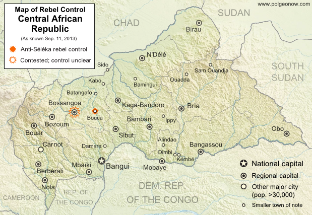
Map of control in the Central African Republic's anti-Seleka counter-rebellion, including towns of Bouca and Bossangoa
Counter-rebels briefly captured at least one Central African Republic town in September (click for full map and article). Map by Evan Centanni from this map by Wikimedia user Keitsist. License: CC BY-SA

Territory Nominally Reunited
Two weeks ago, Political Geography Now reported on rebel control in the Central African Republic’s new counter-rebellion. Since then, the towns of Bouca and Bossangoa have reportedly both been recaptured by forces belonging to Séléka, the former rebel coalition whose leader is now the president of the Central African Republic.

However, as outrage grows over vicious violence against civilians which has continued since Séléka’s campaign to take over the Central African Republic earlier this year, the new President Michel Djotodia has little actual control over the country.

One another analyst says that “law and order stops outside the presidential palace” in Bangui, and the AFP reported earlier this month that “A large number of [Séléka] fighters answer only to their direct leaders, who have carved out personal fiefdoms in the wake of the rebellion”. This raises serious questions regarding President Djotodia’s claims that he is now dissolving and outlawing the Séléka organization.

More information: Rebel Control Map: Central African Republic’s Counter-Rebellion

To see Séléka’s rise to power illustrated in rebel-control maps, view all Central African Republic articles.

Rebel Control Map: Central African Republic’s Counter-Rebellion (September 2013)

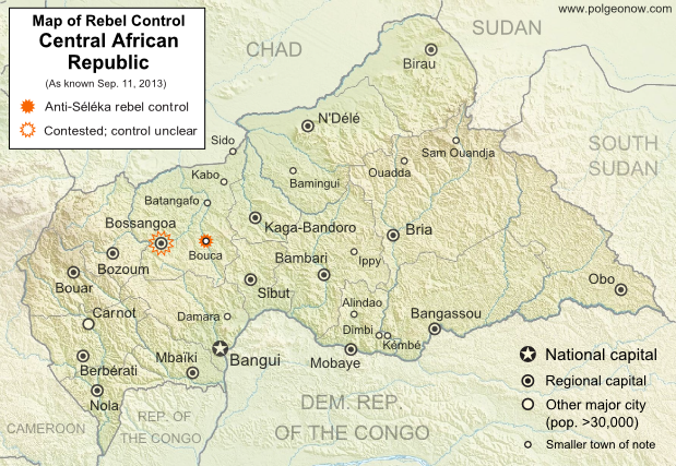
Map of 2013 counter-rebellion in the Central African Republic, showing current control by anti-Séléka (possibly pro-Bozizé) rebels as known on September 11, 2013.
Little sooner than Séléka rebel leader was sworn in as president, a new counter-rebellion has sprung up in the Central African Republic. Map by Evan Centanni from this map by Wikimedia user Keitsist. License: CC BY-SA

Previously: Séléka Coalition Takes Control of Central African Republic (Map of Rebel Advance)

Rebellion and Counter-Rebellion
Starting last December, a rebel coalition called Séléka swept across the Central African Republic from the north, capturing much of the country by January (see our first map of rebel control in the CAR). After a short-lived attempt at peace, Séléka renewed its campaign, capturing the capital and forcing President François Bozizé to flee the country. Rebel leader Michel Djotodia declared himself president, and Séléka has remained the major power in the country despite outbreaks of violence and general chaos.

Flag of the Central African RepublicCountry Name:  
• Central African Republic (English)
• Centrafrique (French)
• Bêafrîka (Sango)
Official Name:  
• Central African Republic (English)
• République centrafricaine (French)
• Ködörösêse tî Bêafrîka (Sango)
Capital: Bangui

Djotodia consolidated his power with an official presidential inauguration last month, but the conflict has proven to be far from settled. This Monday, heavy fighting broke out near Bossangoa, a city in the northwest, with anti-Séléka rebels reportedly taking over six unspecified towns in the area. Djotodia’s government said Bouca was one of the captured towns, while blaming the uprising on supporters of former president Bozizé.

The area is indeed Bozizé’s home region, though the rebels may not all be his supporters. A newspaper from Ghana reported that the rebels called themselves Anti-Balaka, which it translated as “Anti-Machete”. The same report also indicated that Bossangoa itself had fallen under rebel control, though other sources only state that fighting is ongoing in the surrounding villages as the city is being abandoned by fleeing civilians.

Stay tuned to Political Geography Now’s Central African Republic channel for updated maps of this evolving situation!

Related:
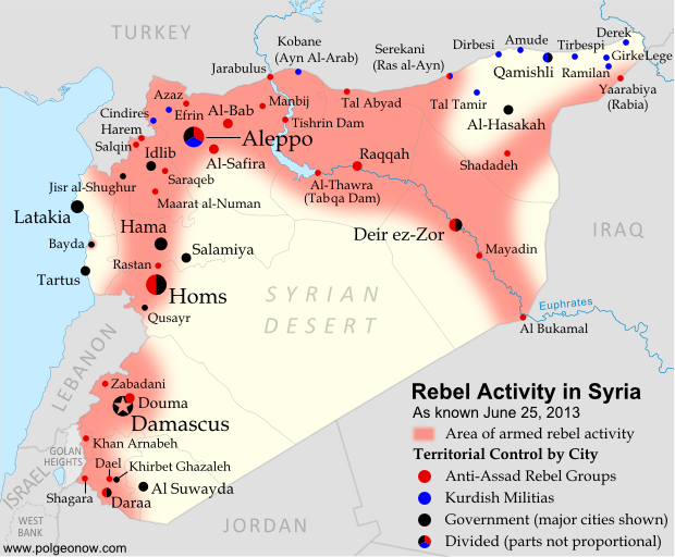
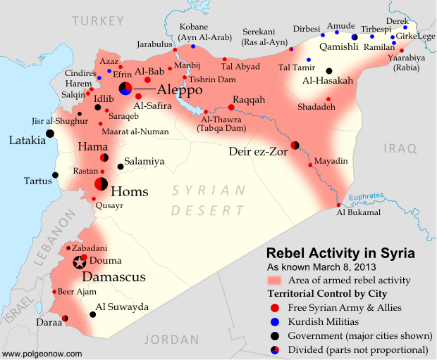
Syrian Civil War Control Map
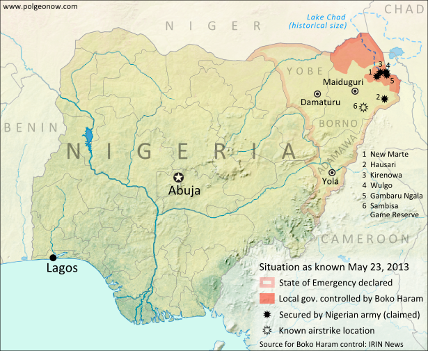
Map of Nigeria’s War on Boko Haram
War in Somalia: Map of Al Shabaab Control

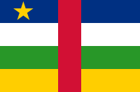
Graphic of the flag of the Central African Republic is in the public domain (source).

Mali Conflict Map: National Territory Reunited Ahead of Elections (July 2013)

There are newer versions of this map available. To see them, view all Mali maps. 

This is an update within our Mali conflict map series – for the original story, see Mali Map: Islamist Control & French Intervention

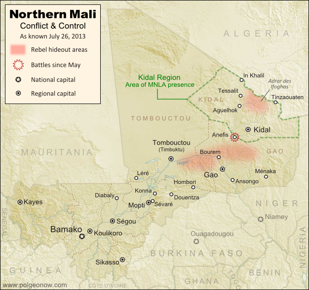
Updated map of fighting and territorial control in Mali during the 2013 French and African intervention against Islamist rebel groups MUJAO, Ansar Dine, and Al Qaeda in the Islamic Maghreb (AQIM). Reflects the situation as of July 27, 2013, including the Kidal region claimed by the Tuareg rebels of the National Movement for the Liberation of Azawad (MNLA).
Updated map of situation in Mali ahead of elections on July 28, 2013. Map by Evan Centanni, modified from Wikimedia map by Orionist, using images by Carport and NordNordWest (source). License: CC BY-SA.

Army Returns to Kidal
As shown on the previous edition of our Mali war map, January’s French intervention against religious extremists returned most of the country to government control, but left the northeastern province of Kidal in the hands of the Tuareg-dominated rebels of the National Movement for the Liberation of Azawad (MNLA). The MNLA had insisted that the Malian army not be allowed into Kidal, citing the army’s alleged abuses against Tuareg and Arab people, leading France to seek negotiations between the MNLA and Mali’s central government.

The Malian government likewise insisted that it be allowed into Kidal prior to national elections on July 28th, and the army at one point appeared poised to fight its way in by force, capturing the provincial border town of Anefis in early June. However, after two more weeks, the government and the MNLA signed a formal deal, agreeing to put off questions of autonomy for the north until after the elections. Under the agreement, Mali’s army was allowed to peacefully enter Kidal, and MNLA soldiers returned to their camps.

Flag of MaliCountry Name:  
• Mali (English, French, Bambara)
Official Name:  
• Republic of Mali (English)
• République du Mali (French) 
• Mali ka Fasojamana (Bambara)
Capital: Bamako

U.N. Peacekeeping Mission Begins
A new U.N. peacekeeping mission in Mali, called MINUSMA, officially began on July 1st. The mission replaces the international African force already in the country, a coalition of West African neighbor countries plus Chad, under U.N. command. In addition to the U.N. peacekeepers, there are also still 3,200 French troops remaining in Mali.

What About the Islamist Rebels?
Religious extremist rebel groups Ansar Dine and the Movement for Unity and Jihad in West Africa (MUJAO), which last year controlled all of northern Mali, have mostly gone into hiding since the French intervention – Ansar Dine in the Adrar des Ifoghas mountains of Kidal, and MUJAO in the area of Gao and nearby stretches of the Niger River. Al Qaeda’s local branch, AQIM, is also present.

Our last Mali war map showed continuing battles against the rebels even in the north’s major cities, but since May the fighting has mostly come to an end, with the militants avoiding rather than confronting the French army’s ongoing expeditions into the desert. The only major fighting reported since our last update was a clash between MUJAO rebels and the MNLA in Anefis, prior to the town being taken by the Malian army.

Related Articles:

Nigeria War Map: Boko Haram Loses Territory

Graphic of Malian flag is in the public domain (source).

Nigeria Map Update: War on Boko Haram Continues After Decline in Rebel Control

There are newer versions of this map available. To see them, view all Nigeria updates.

Two months ago, Political Geography Now published a map of Boko Haram rebel control in Nigeria as the government declared a state of emergency and began a large-scale military intervention. We now present an updated map of the continued fighting and attacks following the rebels’ apparent loss of any significant territorial control.

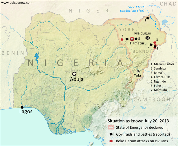
Map of battles, government raids, and rebel attacks in Nigeria's war with Boko Haram and declared state of emergency. Updated for July 2013.
Map of fighting and attacks in Nigeria’s war against the rebels of Boko Haram. Map by Evan Centanni.

Boko Haram Loses Territorial Control
As shown in our first map of the Boko Haram rebellion in Nigeria, a few months ago the rebels reportedly had actual territorial control of several areas of the country’s northeast. Details of events related to Nigeria’s military crackdown are sometimes fuzzy due to communications blackouts and lack of press access; but according to government reports, Boko Haram’s bases have been decimated by the ongoing intervention, and the region has generally fallen back under government control.

Boko Haram is a decade-old rebel movement which seeks to banish all Western education and influence in favor of strict Islamic law for Nigeria’s north.

Flag of NigeriaCountry Name:  
• Nigeria*
Official Name:  
• Federal Republic of Nigeria*
Capital: Abuja
*There are hundreds of languages spoken in Nigeria, but only English is official.

Continued Fighting
Though the rebels have reportedly been mostly driven from their bases, they have not given up or fled Nigeria entirely. Compared to a few months ago, violence seems to have abated along the former shores of Lake Chad in favor of moving into the region’s hills and urban centers.

Nigerian government forces have launched raids targeting Boko Haram guerrillas in the Sambisa forest and Gwoza Hills of southeastern Borno State, Mallam Futori near the northern border, and locations such as Ngamdu and Fune in the neighboring state of Yobe. There have also been multiple major battles in the Borno State capital city of Maiduguri. Adamawa, the third Nigerian state in which the state of emergency was declared, has been relatively quiet.

Boko Haram Attacks
Meanwhile, the Boko Haram rebels have been defying the Nigerian army by continuing to launch bloody attacks on civilian targets in Borno and Yobe. Most infamous are two recent massacres at high schools in Mamudo and the Yobe state capital of Damataru, which the rebels say are a necessary part of their struggle against Western education. They have also sacked villages in the Gwoza Hills, as well as the nearby towns of Gwoza and Bama. Nigerian government forces have also been accused of serious human rights abuses.

The government of Nigeria claimed last week that a ceasefire deal with Boko Haram was under negotiation, but the head of the rebel group, Abubakar Shekau, later denied this.

Related Articles:

Graphic of the Nigerian flag is in the public domain (source).

Egypt Suspended from African Union

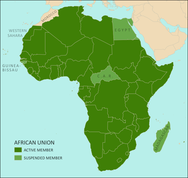
Map of the African Union, including active and suspended members, updated for the July 2013 suspension of Egypt (colorblind accessible).
The African Union. Map by Evan Centanni, from this blank map by Eric Gaba. License: CC BY-SA

Flag of the Arab Republic of Egypt Country Name:  
• Egypt (English)
Miṣr (Arabic)
Official Name:  
• Arab Republic of Egypt (English)
• Ǧumhūriyyat Miṣr al-ʿArabiyyah (Arabic)
Capital: Cairo

Article by Evan Centanni

African Union Suspends Egypt
Egypt, the third most populous country in Africa, was suspended last weekend from that continent’s regional organization, the African Union (AU). The suspension comes after months of unrest in the country, in which massive popular protests led to the military overthrow of the government last week. The suspension is being taken very seriously by the parties involved.

The AU’s Peace and Security Council typically suspends member countries when they experience coups or other breakdowns of constitutional rule. Egypt joins three other African countries which are also currently suspended for similar incidents: Madagascar, Guinea-Bissau, and the Central African Republic (CAR) (see the links for information on each country’s constitutional crisis).

See Also: Rebel Takeover of Central African Republic (map)

What is the African Union?

Flag of the African Union (AU)Organization Name:  
• African Union (English)
• al-Āthḥād al-’Āfrīqī (Arabic)
• Union africaine (French)
• União Africana (Portuguese)
• Unión Africana (Spanish)
• Umoja wa Afrika (Swahili)  
Launched: 2002 in Durban, South Africa
Headquarters: Addis Ababba, Ethiopia
Website: www.au.int

Formed in 1999-2002 to replace the earlier Organization of African Unity (OAU), the AU is an intergovernmental organization which works on increasing cooperation, stability, and development within the continent of Africa. It has a secretariat based in Addis Ababa, Ethiopia, though many of its most important decisions are made during annual summits of the continent’s national leaders.

Every UN-recognized country in Africa is a member of the African Union except for Morocco, which withdrew from the OAU in 1984 after the organization chose to admit the partially recognized state of Western Sahara, a disputed territory which Morocco claims and largely occupies. The only other parts of Africa not represented in the AU are a few groups of offshore islands controlled by European countries, as well the small Spanish enclaves in North Africa. The breakaway Republic of Somaliland is not a member, but is considered by the AU to be part of Somalia.

Low-resolution graphic of the African Union flag is displayed under fair use principles (source).

Related Articles:

Croatia Joins EU, Leaves CEFTA

War in Somalia: Map of Al Shabaab Control (June 2013)

There are newer versions of this map available. To see them, view all Somalia articles on PolGeoNow.

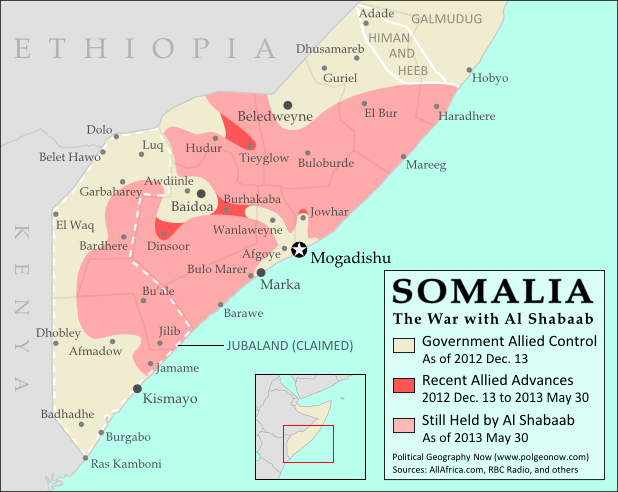
Since the beginning of the year, Somalia’s federal government and its allies have made some major breakthroughs in the war to take back the country from Al Shabaab, Somalia’s local branch of Al Qaeda. This is the third installment in our series of Al Shabaab control maps, marking territorial changes since our last Somalia map update in December 2012.

Map of Al Shabaab control in southern Somalia just before June 2013, highlighting recent advances by government and African Union troops since December. Includes the newly recaptured Mogadishu-Baidoa highway corridor, plus Bulo Marer, site of crashed U.S. drone aircraft. Also marks claimed territory of Jubaland state.
Southern Somalia: recent government-allied advances in the war against Al Shabaab. Original map by Evan Centanni. Incorporates elements from this blank map by Eric Gaba and this locator map by TheEmirr. (license: CC BY-SA).

Connecting Mogadishu and Baidoa
After news came in of the Somali Federal Government and its allies completing their control of southern Somalia’s major cities last fall, further progress against the Al Qaeda affiliate group Al Shabaab at first made only slow progress. But since the beginning of this year, at least one major breakthrough has been made.

Background & Actor Profiles: War in Somalia – The Retreat of Al Shabaab 

After several years of being cut off by Al Shabaab, Mogadishu and the key inland city of Baidoa were finally reconnected in February after African Union and Somali forces captured Burhakaba, the last major town lying on the highway between the two cities. As a result, the Al Shabaab’s territory in Somalia has been split into two pieces, though security is probably not so tight that the militants can’t slip back and forth across the narrow band held by the Somali government.

Flag of SomaliaCountry Name:  
Somalia (English)
Soomaaliya (Somali)
• aṣ-Ṣūmāl (Arabic)
Official Name:  
Federal Republic of Somalia (English)
Jamhuuriyadda Federaalka Soomaaliya (Somali)
Jumhūriyyat aṣ-Ṣūmāl al-Fideraaliya (Arabic) 
Capital: Mogadishu

Ethiopian and Somali troops had previously taken the town of Dinsoor, another major town in the region of Baidoa, in mid-December (just after our previous Somalia map update). And fighting in the area continued after the captured of Burhakaba as well, with the Baidoa suburb of Aw Diinle falling to Al Shabaab in March. Although it was reported recaptured soon afterwards, Al Shabaab forces were apparently still present until just a couple weeks ago.

Ethiopian Withdrawal
The town of Hudur north of Baidoa was recaptured by Al Shabaab in March after Ethiopian forces withdrew from the town. Ethiopia soon reported that it would be withdrawing completely from the war in Somalia in the near future.

This is important news, since the Ethiopians have been the major force in the war against Al Shabaab near the Ethiopia-Somalia border for the past year and a half. The African Union Mission in Somalia (AMISOM) has slowly rolled into position to fill the gap, but Ethiopia has still not yet completely withdrawn.

Meanwhile, Somalia’s own army reportedly scored a victory with the capture of Tiyeglow town east of Hudur in May. Hudur itself, however, is apparently still Al Shabaab territory, despite early reports suggesting it was recaptured by Somali forces.

Somalia’s Airspace
The federal government of Somalia announced recently that the country’s airspace will be returning to its control after nearly two decades of U.N. stewardship. However, the northern Somali breakaway state of Somaliland (not shown on this map) has reacted with anger, announcing the seizure of its own airspace from the U.N. in order to preempt the takeover by Mogadishu.

And in other news related to air power, the Somali government and AMISOM last February seized a strategic airfield north of the town of Jowhar, which will help the allies project their power as they push the war ever deeper into Al Shabaab’s remaining territory. The U.S. also has a covert presence in Somalia’s skies and one of its drone aircraft is believed to have crashed this week over the Al Shabaab base of Bulo Marer, not far from the port city of Marka.

Political Struggle for Jubaland
After the capture of Kismayo port by Kenyan forces last September, a political power struggle has emerged in the city. Local groups, backed by Kenya and other neighboring countries, have declared an autonomous area called Jubaland, which claims three of the surrounding administrative regions as a federal state of Somalia.

The central government in Mogadishu, which did not approve the plan, has vigorously opposed Jubaland’s formation, but political conflict and confusion continues in Kismayo, where the leader of the Ras Kamboni militia is now claiming to be the state’s elected president.

Stay Up-to-Date: See past and future updates to this map by filtering for posts about Al Shabaab, or view all Somalia articles.

Related Articles:

Graphic of Somali flag is in the public domain (source).