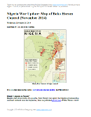
Nigeria War Update: Map of Boko Haram Control (November 2014) (Premium)

There are newer versions of this map available. To see them, view all Nigeria updates.

Detailed map of Boko Haram's territorial control in its war with Nigeria, marking and labeling each town reportedly under the group's control in Borno, Yobe, and Adamawa states. Includes recent flashpoints such as Chibok, Mubi, Maiha, Abadam, Malam Fatori, and Damasak.

Download PDF
Buy now

(Subscribe via Paypal to view all premium content online)

Reporting by T.H. and Evan Centanni

Despite short-lived claims of a ceasefire, Nigeria’s northern insurgency has continued unabated since late September, when we published our free map of Boko Haram control in Nigeria.

This premium report and map update detail the many changes since then, which have seen Boko Haram’s “Islamic Caliphate” grow to control an area the size of Belgium.

This map and article are exclusive premium content, available only to paid members or for individual purchase. Buy now (US$9.99)

Premium report includes:

  • Map of Boko Haram’s overall area of control in Nigeria, updated to Nov. 25, 2014.
  • Detailed map shows almost every individual town or village known to have been captured by the group, including recent flashpoints like Chibok, Mubi, and Abadam.
  • Summary and detailed timeline of territorial changes and major events since late September.

MEMBERS CLICK HERE TO PROCEED TO ARTICLE AND MAP

NOT A MEMBER YET? SUBSCRIBE NOW!

Portuguese Community Admits New Member & Observer Countries (Map)

Map of the Community of Portuguese Language Countries (CPLP), including both member states and associated observers. Updated for the July 2014 summit, which admitted new member Equatorial Guinea and new associate observers Georgia, Japan, Namibia, and Turkey (colorblind accessible).
Map by Evan Centanni, starting from public domain blank map (license: CC BY-NC-SA).

Premium members click here to view this article in the ad-free members area. Not a member yet? Subscribe now!

Article by Karina Barquet

Flag of the Community of Portuguese Language Countries (aka Community of Portuguese-speaking Countries, CPLP)Organization Name:  
• Community of Portuguese Language Countries (English)
• Community of Portuguese-Speaking Countries (English – alternative name)
• Comunidade dos Países de Língua Portuguesa (Portuguese)
Founded: 1996 in Lisbon, Portugal
Headquarters: Lisbon, Portugal
Website: www.cplp.org

New Member Country for CPLP
The Community of Portuguese Language Countries (known by the Portuguese acronym CPLP) welcomed a new member this year. Equatorial Guinea joined the organization following its approval at the 10th CPLP Heads of State Summit in Dili, East Timor on July 23, 2014.

The CPLP is an intergovernmental organization for cooperation amongst countries where Portuguese is an official language. It was  founded in 1996 with seven member countries: Portugal, Brazil, Angola, Cape Verde, Guinea-Bissau, Mozambique, and São Tomé and Príncipe. East Timor joined the community in 2002 after gaining independence.

New Observer Countries
In addition to new member Equatorial Guinea, the CPLP’s July 2014 summit also admitted four new Associate Observer countries: Georgia, Japan, Namibia, and Turkey. These joined the two previously-admitted Associate Observers, Mauritius and Senegal.

Equatorial Guinea is a small country located in Central Africa. Its name reflects the country’s location near both the equator and the Gulf of Guinea. Equatorial Guinea is a former Spanish colony, and Spanish is the first official language, followed by French. A new law drafted in 2011 declared Portuguese the third official language in the country, though it is unclear whether that law ever went into effect.

The push to adopt Portuguese as an official language was a result of President Obiang’s efforts in 2007 to improve communications, trade, and bilateral relations with Portuguese-speaking countries, and to meet an important requirement to become a full member of the CPLP. Other requirements for joining CPLP included political reforms to give room for effective democracy and respect for human rights.

The 10th Summit also saw the reincorporation of Guinea-Bissau as a full member of the CPLP, after its suspension following a coup d’etat in April 2012. Guinea-Bissau was readmitted in the wake of the country’s recent presidential and legislative elections, and the transition of the CPLP’s presidency from President of Mozambique, Armando Guebuza, to the President of East Timor, Matan Ruak, who will be in office for the next two years.

Low-resolution graphic of the CPLP flag is displayed under fair use principles (source).

War in Nigeria: Map of Boko Haram Control (September 2014)

There are newer versions of this map available. To see them, view all Nigeria updates.

Detailed map of Boko Haram territorial control in its war with Nigeria, marking and labeling each town reportedly under the group's control in Borno, Yobe, and Adamawa states. Includes Damboa, Buni Yadi, Madagali, Gwoza, Gujba, Gulak, Bama, Gulani, Shuwa, Marte, Kukawa, Michika, Dikwa, Bularafa, Bazza, Gambaru Ngala, Buni Gari, Banki, Bara, Pulka, Bumsa, Ashgashiya, Limankara, Njibulwa and more.
Map by Evan Centanni. All rights reserved.

Premium members click here to view this article in the ad-free members area. Not a member yet? Sign up now!

Conflict tracking by T.H., with additional reporting by Evan Centanni

Boko Haram vs. Nigeria
Though it’s waged a bloody war against the Nigerian government for many years, rebel group Boko Haram rarely could claim significant territorial control until recently. Though they did take over a number of remote areas in spring of last year (see our 2013 Boko Haram control map), the militants were soon driven back into hiding by the Nigerian military.

The insurgency never went away, with Boko Haram’s bombings and other attacks, often on schools and other public places, increasing in number and lethality from 2013 into early 2014. (Also see our 2013 report for more background on Boko Haram).

Territorial Resurgence
However, this summer saw a striking change in the trajectory of Boko Haram’s rebellion. Likely inspired by the Islamic State organization in Iraq and Syria, Boko Haram initiated a new strategy of capturing and holding towns and villages. The campaign began in late July, and has gone much farther than last year’s seizure of several small towns. By early September there was talk of an imminent invasion of Maiduguri, the capital of Nigeria’s far northeastern Borno State. That hasn’t happened yet, but neither does Boko Haram seem to be abandoning its newly won territory anytime soon.
Flag of NigeriaCountry Name:  
• Nigeria*
Official Name:  
• Federal Republic of Nigeria*
Capital: Abuja
*There are hundreds of local languages in Nigeria, but only English is official.

Chronology of Events
The following is a timeline of major events and changes to territorial control since Boko Haram began seizing towns in northeastern Nigeria this summer.

2014.04.15 Boko Haram kidnaps hundreds of schoolgirls in Chibok, Borno State, gaining attention from around the world. At this time, Boko Haram is not yet known to hold any clearly-defined territory. As of September 2014, the Chibok girls are apparently still missing, and the town is said to be abandoned.

2014.07 Boko Haram erects tollgates on major routes in northern and central Borno State, where it holds rural influence.

2014.07.21 Boko Haram reportedly captures Damboa, raising its flag over the major Borno town.

2014.07.23 Boko Haram destroys a bridge between Maiduguri and Ngala, Borno State. Current control of Damboa is unclear, but there is no government presence.

2014.07.28 Apparent consensus that Boko Haram controls Damboa and the surrounding local government area

2014.08.03 Around this time, Boko Haram takes over Gujba, its first town captured in Yobe State.

2014.08.06 Boko Haram seizes the key town of Gwoza in Borno.

2014.09.10 Around this time, Boko Haram occupies the town of Ashigashia just outside Nigeria’s borders, in neighboring Cameroon.

2014.08.11 Nigerian government claims to have recaptured Damboa. A month later, the town is reportedly still deserted.

2014.08.17 Over the weekend, Boko Haram reportedly takes control of Michika in Adamawa State, but the town will be more widely reported as captured three weeks later.

2014.08.21 Boko Haram takes Buni Yadi in Yobe State.

2014.08.21 Boko Haram captures Madagali, Adawama State.

2014.08.23 Boko Haram takes over Pulka, Borno State.

2014.08.24 Media report that Boko Haram leader Abubakar Shekau has declared a “caliphate” (Islamic empire) in Gwoza, but he may only have meant that it was now ruled according to Islamic law.

2014.08.25 Boko Haram captures Ngala and Gambaru, Borno State.

2014.08.28 Boko Haram captures Dikwa and Marte, Borno State.

2014.08.29 Cameroon’s military retakes Ashigashia town from Boko Haram.

2014.09.01 Boko Haram attacks Bama, Borno State.

2014.09.02 Bara in Yobe State captured by Boko Haram.

2014.09.02 Boko Haram allegedly captures Bama, a major town in Borno, but the situation remains unclear.

2014.09.03 Boko Haram seizes Banki in Borno State and Gulani in Yobe State.

Map of Boko Haram control in Nigeria in May 2013
Boko Haram control in Nigeria, 2013 (click for free map and report).

2014.09.07 Boko Haram captures town of Gulak, Adamawa State.

2014.09.08 Boko Haram captures Michika, Adamawa State. Government claims to recapture Bama.

2014.09.10 Nigerian military claims to recapture Michika, Uba, and Gulak.

2014.09.11 Bama residents say Boko Haram controls the town, despite continued government insistence to the contrary.

2014.09.13 Unidentified Boko Haram commander reportedly captured during attempt to occupy Konduga.

2014.09.18 Catholic Church source says Boko Haram now controls 25 towns. In addition to locations already mentioned, the list includes Shuwa, Kukawa, Bularafa, Bazza, Buni Gari, Bumsa, Taltaba*, Limankara, and Njibulwa. Michika, Gulak, and Ashigashia are also still listed despite earlier claims they were retaken by government forces. A longer accounting of “31 towns and villages” adds Wulgo, Ngoshe, Attagara, Barawa*, Arbokko, Kirawa.

2014.09.19 Nigerian government begins investigating the possible death of Boko Haram leader Abubakar Shekau. The army of Cameroon also took credit for Shekau’s death, but some believe he was actually killed over a year ago, and that the recent death was of an imposter.

2014.09.26 Boko Haram again tries to capture Konduga, on the way into Borno State capital Maiduguri, but is stopped by government forces.


*PolGeoNow was unable to determine the precise geographical locations of Taltaba and Barawa. For this reason, they do not appear on the above map.

Don’t miss future updates to the map of Boko Haram control in Nigeria! Become a member now!

Graphic of the Nigerian flag is in the public domain (source).

African Union Reinstates Egypt and Guinea-Bissau (Map)

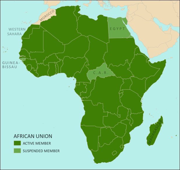
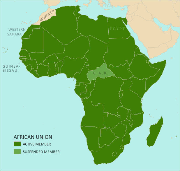
Map of the African Union, including active and suspended members, updated for the June 2014 reinstatement of Egypt and Guinea-Bissau (colorblind accessible).
The African Union as of July 2014. Map by Evan Centanni, from this blank map by Eric Gaba.
License: CC BY-SA

Premium members click here to view this article in the ad-free members area. Not a member yet? Subscribe now!

Article by Evan Centanni

Suspensions Lifted
At a meeting in June, the African Union (AU) decided to end the suspensions of Egypt and Guinea-Bissau from the regional organization. Egypt was suspended from the AU last year after its elected government was overthrown by the military. Its reinstatement comes after the events of this May, when the country held its first presidential election since the takeover. Guinea-Bissau had been suspended since a 2012 coup, and was similarly allowed back in after holding elections this April.

The AU’s Peace and Security Council typically suspends member countries when they experience coups or other breakdowns of constitutional rule. Though this is billed as a pro-democracy policy, it does not affect undemocratic governments which are already long-established. After Guinea-Bissau and Egypt’s reinstatement, there is currently only one remaining suspended AU member, the Central African Republic (CAR), which is experiencing serious turmoil in the aftermath of an aborted rebel takeover.

Flag of the African Union (AU)Organization Name:  
• African Union (English)
• al-Āthḥād al-’Āfrīqī (Arabic)
• Union africaine (French)
• União Africana (Portuguese)
• Unión Africana (Spanish)
• Umoja wa Afrika (Swahili)  
Launched: 2002 in Durban, South Africa
Headquarters: Addis Ababba, Ethiopia
Website: www.au.int

What is the African Union?
Formed in 1999-2002 to replace the earlier Organization of African Unity (OAU), the AU is an intergovernmental organization which works on increasing cooperation, stability, and development within the continent of Africa. It has a secretariat based in Addis Ababa, Ethiopia, though many of its most important decisions are made during annual summits of the continent’s national leaders.

Every UN-recognized country in Africa is a member of the African Union except for Morocco, which withdrew from the OAU in 1984 after the organization chose to admit the partially-recognized state of Western Sahara, a disputed territory which Morocco claims and largely occupies. The only other parts of Africa not represented in the AU are a few groups of offshore islands controlled by European countries, as well the small Spanish enclaves in North Africa. The breakaway Republic of Somaliland is not a member, but is considered by the AU to be part of member-state Somalia.

Low-resolution graphic of the African Union flag is displayed under fair use principles (source). Flag of Madagascar is in the public domain (source).

Mayotte Enters European Union

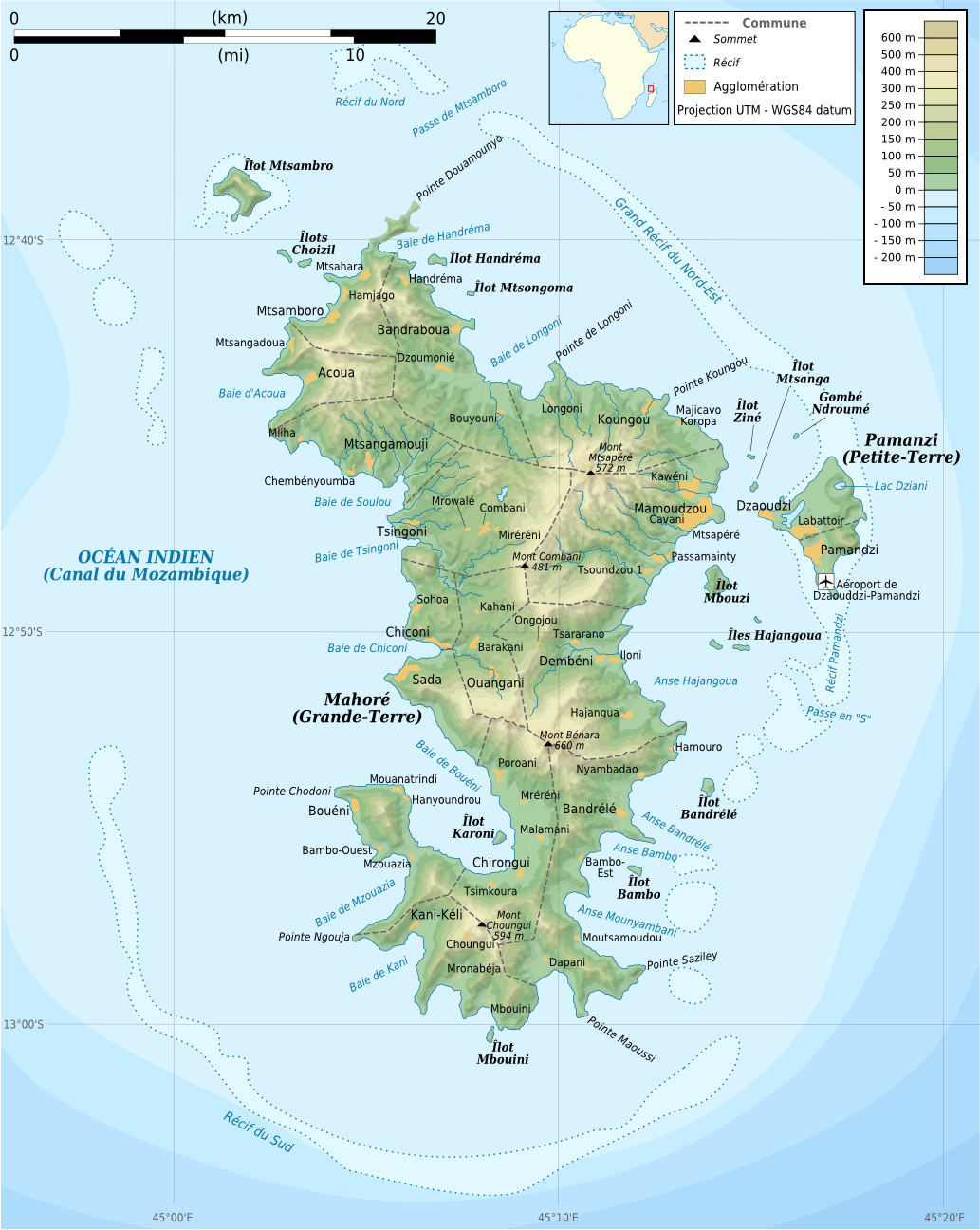
“Outermost regions” are officially part of the European Union; “overseas countries and territories” are not part of the EU itself, but have special relations with it because of their connections to member countries. New outermost region Mayotte is located in southeastern Africa. Map from Wikimedia Commons © Alexrk2 (CC BY-SA)

Premium members click here to view this article in the ad-free members area. Not a member yet? Subscribe now!

Article by Evan Centanni

EU Expands to Include Mayotte
You probably heard about Croatia joining the European Union last year, but did you know the EU expanded further this year…in Africa? The French overseas department of Mayotte, a group of islands in the Indian Ocean northwest of Madagascar, became officially part of the EU on January 1.

Mayotte’s entrance into the European Union is the result of it becoming an “overseas department” of France in March 2011. An overseas department is considered to be fully part of France, just like any other of the country’s departments (a governmental unit similar to a province or county). This means that the people are represented in the French legislature and can vote in both French and European Union elections.

Topographic map of Mayotte, an Indian Ocean island group which is part of France, and which became officially part of the European Union as well on January 1, 2014
Map of Mayotte from Wikimedia Commons © Rémi Kaupp, with elements by Sting (CC BY-SA)

A Series of Referendums
Mayotte became a French colony in 1841, after centuries of rule by East African kingdoms. Part of the Comoro Islands, an archipelago located between Madagascar and mainland Africa, the people of Mayotte were allowed a vote on the question of independence in 1974.

Independence proved very popular on the rest of the Comoro Islands, which soon became the independent Union of the Comoros (still one of the world’s nearly 200 independent countries today). Mayotte itself, however, voted against it. The majority of its people preferred to remain a French territory, and reaffirmed this with a vote of 99% against joining the independent Comoros in 1976. (The Comoros still claim Mayotte as their own, with a 1976 UN Security Council resolution in their support failing after a rare French veto).

At that time, Mayotte was an overseas territory belonging to France, but not considered part of the country itself. However, in 2000 the islands voted to enter a ten-year transition period on the way to joining France proper as an overseas department. From 2001 to 2011, Mayotte was a “departmental collectivity”, neither a normal territory nor an actual department yet. A final referendum in 2009 confirmed that it would become an overseas department in 2011.

Unofficial flag of Mayotte, used locally Name:  
• Mayotte (English, French)
Full Name:  
• Department of Mayotte (English)
• Département de Mayotte (French)
Claimants: France, Comoros
Actual Control: France
Administrative Status: Integral part of France (overseas department)
Capital: Mamoudzou
Demonym: Mahoran

Though becoming part of the EU was an expected outcome of gaining department status, Mayotte’s entry into the organization was not set to take effect until Jan. 1, 2014. The occasion of Mayotte’s entry into the EU was marked by a special visit from the flagship of the European Union Naval Force.

“Outermost Region”
Within the European Union Mayotte is now classified as an “outermost region”. This means that it’s subject to most EU laws, but may be eligible for some exceptions because of practical issues related to not actually being in Europe. For example, other French outermost regions use the euro as their currency, but don’t collect EU value-added tax (VAT) and maintain separate border controls. Mayotte is now one of two EU outermost regions located in the Indian Ocean, the other being fellow overseas department Réunion.

Graphic of the locally-used flag of Mayotte is in the public domain (source).
ICYMI: The Gambia’s Withdrawal from the Commonwealth

“In case you missed it” – this is an article featuring news we couldn’t cover when it first broke, but that we thought you might still want to know about. Those who read our article on the year 2013 in political geography changes already heard about the Gambia’s withdrawal from the Commonwealth of Nations – now here’s the full story.

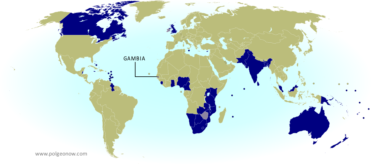
Map of current and former member countries of the Commonwealth of Nations (British Commonwealth) as of 2014, marking the Gambia, which recently withdrew from the organization (colorblind accessible).
The Commonwealth of Nations. Current members in dark blue, former members in lavender. Map by Evan Centanni, modified from public domain blank map.

Premium members click here to view this article in the ad-free members area. Not a member yet? Subscribe now!

Flag of the Gambia Country Name:  
• The Gambia
Official Name:  
• Republic of the Gambia
Capital: Banjul

Article by Evan Centanni

Unceremonious Departure
The Gambia, a small country in West Africa, withdrew from the Commonwealth of Nations last October in an unexpected move by idiosyncratic dictator Yahya Jammeh. The official announcement gave no explicit reason for leaving, but it did include language rejecting “neo-colonialism”.

Sometimes called the “British Commonwealth”, the Commonwealth of Nations is mainly a forum for cooperation between countries that were once parts of the British Empire (though it has also admitted other countries in the past). But any association it has with British colonialism is mostly symbolic – although Queen Elizabeth II is the formal “Head of the Commonwealth”, within the organization itself, all members are equal and decisions are made by consensus.

See Also: 2013: The Year in Political Geography Changes

Flag of the Commonwealth of NationsOrganization Name:  
• Commonwealth of Nations
Founded: 1931 and 1949 in London, U.K.
Headquarters: London, U.K.
Website: thecommonwealth.org/

But the Commonwealth does involve itself in the promotion of human rights and democratic government, and this might be how it ran afoul of the Gambia’s ruler. In 2012 Jammeh had rejected a Commonwealth proposal to open commissions in the Gambia for human rights, press freedom, and opposition to corruption. Meanwhile, in early 2013 the country scored especially low in the U.K.’s Human Rights and Democracy report.

Commonwealth Members
The Commonwealth of Nations now has 53 members, all of them independent countries which also have membership in the U.N. Participation in the Commonwealth is completely voluntary, and any member country can leave or reapply at will. Besides the Gambia, there are only two other former Commonwealth members in the world today. Founding member Ireland left when it broke ties with the U.K. in 1949, and Zimbabwe exited in 2003 after a year of suspension over democratic irregularities.

It’s a common misconception that countries must recognize the queen of England as their monarch in order to be members of the Commonwealth. In fact, many Commonwealth members are republics with no monarchies. The countries that do share the queen are a subset known as the “Commonwealth Realms“. Elizabeth II’s current title of “Head of the Commonwealth” is separate from her role as the queen of the Realms, gives her no authority over member countries, and won’t be automatically inherited by her successor.

See Also: Queen Elizabeth’s 16 Countries: The Commonwealth Realms

Low-resolution graphic of the Commonwealth flag is displayed under fair use principles (source). Flag of the Gambia is in the public domain (source).
Madagascar Un-Suspended from African Union

Map of the African Union, including active and suspended members, updated for the January 2014 reinstatement of Madagascar (colorblind accessible).
The African Union as of March 2014. Map by Evan Centanni, from this blank map by Eric Gaba.
License: CC BY-SA

Premium members click here to view this article in the ad-free members area. Not a member yet? Subscribe now!

Flag of Madagascar Country Name:  
• Madagascar (English, French)
Madagasikara (Malagasy)
Official Name:  
• Republic of Madagascar (English)
• Repoblikan’i Madagasikara (Malagasy)
• République de Madagascar (French)
Capital: Antananarivo

Article by Evan Centanni

Madagascar Suspension Ends
This past January, the African Union decided to lift the suspension of Madagascar from the regional organization. Madagascar’s membership was suspended in 2009, after the president was forced out in popularly-supported military coup. The country’s reinstatement to the AU follows a new presidential election this past December

The AU’s Peace and Security Council typically suspends member countries when they experience coups or other breakdowns of constitutional rule. Though this is billed as a pro-democracy policy, it does not affect undemocratic governments which are already long-established. After Madagascar’s reinstatement, there are currently three remaining suspended AU members: Guinea-Bissau, the Central African Republic (CAR), and Egypt, whose suspension we reported on last year.

See Also: Rebel Takeover of Central African Republic (map)

What is the African Union?

Flag of the African Union (AU)Organization Name:  
• African Union (English)
• al-Āthḥād al-’Āfrīqī (Arabic)
• Union africaine (French)
• União Africana (Portuguese)
• Unión Africana (Spanish)
• Umoja wa Afrika (Swahili)  
Launched: 2002 in Durban, South Africa
Headquarters: Addis Ababba, Ethiopia
Website: www.au.int

Formed in 1999-2002 to replace the earlier Organization of African Unity (OAU), the AU is an intergovernmental organization which works on increasing cooperation, stability, and development within the continent of Africa. It has a secretariat based in Addis Ababa, Ethiopia, though many of its most important decisions are made during annual summits of the continent’s national leaders.

Every UN-recognized country in Africa is a member of the African Union except for Morocco, which withdrew from the OAU in 1984 after the organization chose to admit the partially-recognized state of Western Sahara, a disputed territory which Morocco claims and largely occupies. The only other parts of Africa not represented in the AU are a few groups of offshore islands controlled by European countries, as well the small Spanish enclaves in North Africa. The breakaway Republic of Somaliland is not a member, but is considered by the AU to be part of Somalia.

Low-resolution graphic of the African Union flag is displayed under fair use principles (source). Flag of Madagascar is in the public domain (source).

South Sudan War Map: Control at Time of January Ceasefire (Update #3) (Premium)

Map of rebel control in South Sudan's ongoing rebellion, showing situation at the time of the ceasefire of January 23, 2014

Download PDF
buy

(Subscribe via Paypal)

This is Part 1 of a double map report on territorial control in South Sudan’s ongoing rebellion, available exclusively to premium subscribers or for individual purchase. This map shows territorial control as of January 23, when the warring parties signed their ceasefire agreement (including major changes from previous update). Buy now (US$3.99).

To see the map of current control as of late February, go to Part 2.

Premium article includes:

  • Exclusive map of rebel control at the time the ceasefire was signed on January 23, 2014
  • Multiple changes to territorial control since previous update
  • Several new locations added to the map
  • Report chronicling changes to territorial control and describing the situation at the time of the ceasefire, including links to sources

Members click here to proceed to article and map

Not a member yet? Subscribe Now!

South Sudan War Map: Current Rebel Control (Update #4) (Premium)

Map of rebel control in South Sudan's ongoing rebellion, showing situation at the time of the ceasefire of January 23, 2014

Download PDF
buy

(Subscribe via Paypal)

This is Part 1 of a double map report on territorial control in South Sudan’s ongoing rebellion, available exclusively to premium subscribers or for individual purchase. This map shows current territorial control for late February 2014, including several changes since the time of the ceasefire. Buy now (US$3.99).

To see the map of control at the time of the ceasefire on January 23, see Part 1.

Premium article includes:

  • Exclusive map of current rebel control up to February 21, 2014
  • Multiple changes to territorial control since previous update
  • Several more new locations added to the map
  • Report chronicling changes to territorial control since the ceasefire, including links to sources

Members click here to proceed to article and map

Not a member yet? Subscribe Now!

ICYMI: Cape Verde’s Name Change

In the following weeks, PolGeoNow will be publishing several short “in case you missed it (ICYMI)” articles on events from 2013. This is news that we weren’t able to cover when it first broke, but that we thought our readers might still want to know about.

Premium members click here to view this article in the ad-free members area. Not a member yet? Subscribe now!

Topographic map of Cape Verde, now known officially as Cabo Verde
Cape Verde, now officially Cabo Verde (click to enlarge). Map by Oona Räisänen/Wikimedia (CC BY-SA) (source).

By Evan Centanni

Cape Verde Changes Official Name
If you read our article on the year 2013 in political geography changes, you’ve already heard about the change to Cape Verde’s official English name. But since keeping track of country name changes is one of the primary missions of Political Geography Now, we are now presenting this in-depth report on the topic.

On October 25, 2013, this West African island country changed its official English name at the U.N., from “Cape Verde” to “Cabo Verde”. Unlike other recent country name changes, like those of Libya or Hungary, Cape Verde is changing its short-form official name as well as the long-form one. The long name has also been changed, from “Republic of Cape Verde” to “Republic of Cabo Verde”.

Location on the globe of Cape Verde, now known officially as Cabo Verde
Location of Cabo Verde. Graphic slightly modified from this map by Eddo/Wikimedia (CC BY-SA).

Language Issues
In fact, in its own official language of Portuguese the country has always been known as Cabo Verde, meaning “green cape”. But curiously, partially translated “Cape Verde” has long been the established English name. Perhaps to avoid the inconvenience of juggling these slightly different appellations, the country’s government has now requested to be known only by the fully Portuguese version. It is also promoting a name change in French, from “le Cap-Vert” to just “Cabo Verde”.

How Do You Say That?
The traditional English name of the country, Cape Verde, is pronounced “kayp verd”. On the other hand, the new name is presumably intended to be pronounced as closely as possible to the Portuguese: approximately “kah-bo vehr-dih” (the “e” at the end is pronounced something like an English “short i”). Our bet is that common English usage will default to either “vehr-day” or “vehr-dee”.

What’s in a Name Change?

Flag of Cabo Verde (Cape Verde)Country Name:  
• Cabo Verde (Portugues, official English)
• Cape Verde (traditional English)
Full Name:  
• Republic of Cabo Verde (English)
• República de Cabo Verde (Portugues)
Capital: Praia
Demonym: Cape Verdean (traditional), Cabo Verdean (official)

Ultimately no country’s government can control what people call it in another language, and it’s always been normal for them to be called very different names by speakers of foreign tongues. Think of how Deutschland and Italia are known as “Germany” and “Italy” in English – it would be very difficult to convince all English speakers to switch to the native names. And every language does this. For some, such as Chinese or Arabic, every country’s name is at least a bit different from its native appellation, due to the needs of transliterating from Latin letters into the language’s native script.

What Cape Verde’s change will affect is official usage in the United Nations, and diplomats will also be obliged to use the new name in official English communications. Meanwhile, the international standard list of country codes, ISO 3166-1, is based on U.N. usage, meaning that “Cabo Verde” will soon begin appearing on country lists online and elsewhere (though the change hasn’t come through quite yet).

Some organizations, like National Geographic, which already favors using native names whenever possible, will also oblige the Cape Verdean government in their publications. However, the majority of news media and average people may be reluctant to make the switch, as has been the case with Ivory Coast and East Timor.

Graphic of the flag of Cape Verde (Cabo Verde) is in the public domain (source).