War in Ukraine: Detailed Map of Rebel Control in Donetsk & Luhansk (Premium)

etailed map of rebel control in Ukraine's eastern provinces of Donetsk and Luhansk, claimed by the breakaway Donetsk People's Republic and Lugansk People's Republic. Updated to July 22, 2014

Download PDF
buy

(Subscribe via Paypal to view all premium content online)

All new, detailed map of rebel control in eastern Ukraine’s Donetsk and Luhansk regions, home to the claimed Donetsk People’s Republic, Lugansk People’s Republic, and Federation of Novorossiya. 

Since our last Ukraine update, pro-Russian rebels have captured much more territory in Donetsk and Luhansk regions, but also lost some of their early strongholds. 

This map report is exclusive premium content, available to paid subscribers or for individual purchase.
Buy now (US$9.99)

Premium map includes:

  • All new, detailed map of Donetsk and Luhansk regions, showing both past and current rebel control
  • Indication of which districts and cities have had their administrations occupied by separatists
  • Important locations of rebel military control marked
  • Article with chronology of events since April, and discussion of the meaning of “control”

MEMBERS CLICK HERE TO PROCEED TO ARTICLE AND MAP

NOT A MEMBER YET? SUBSCRIBE NOW!

Map: Yemen Joins WTO

Premium members click here to view this article in the ad-free members area. Not a member yet? Subscribe now!

Map of World Trade Organization (WTO) member and observer countries, updated for July 2014 to include new member Yemen
Member and observer states of the World Trade Organization (WTO). Map by Evan Centanni, starting from public domain blank map (license: CC BY-NC-SA).

By Caleb Centanni 

World Trade Organization Admits Yemen 

The World Trade Organization (WTO), a global organization founded in 1995 to promote the management and expansion of international trade, added Yemen as a new member in late June. This comes after the admission of four new members in 2012, and two more in early 2013.

Logo of the World Trade Organization (WTO) Organization Name:  
• World Trade Organization (English)
• Organisation mondiale du commerce (French)
• Organización Mundial del Comercio (Spanish)
Founded: 1994 in Marrakech, Morocco (commenced in 1995)
Headquarters: Geneva, Switzerland
Website: www.wto.org

Yemen, located on the southern Arabian Peninsula, was approved for membership last October at the Ninth Ministerial Conference of the WTO in Bali, Indonesia. The nation officially became a member on June 26, 2014, placing the entire peninsula under the organization’s representation. Yemen’s admission comes despite recent political turmoil in the country, including an Arab Spring uprising and rebel control of large areas of its territory. Yemen is the seventh least developed member country according to the WTO.

According to the WTO, 97.1% of the world economy now falls under the body’s jurisdiction, and this newest accession brings the organization’s membership to 160. Of the 195 UN-recognized countries in the world, 156 (exactly 80%) are members of the WTO. Another four members are not UN-recognized nations: the Chinese administered territories of Hong Kong and Macau, the European Union, and the disputed state of Taiwan, which participates under the name “Separate Customs Territory of Taiwan, Penghu, Kinmen and Matsu (Chinese Taipei)”.  

There are also 24 WTO “observers”, states that are partially included in the organization and have applied for membership (excepting the Holy See, which does not plan to apply). There are only 14 UN members which are neither members nor observers of the WTO.

WTO logo is displayed without permission, based on fair use principles (source).

Syria Civil War: Territorial Control Map #12.3 (Premium)

There are newer versions of this map available. To see them, view all Syria updates.

Detailed map of fighting and territorial control in Syria's Civil War (Free Syrian Army and Nusra Front rebels, Kurdish groups, ISIS/ISIL/Islamic State and others), updated to July 3, 2014.

Download PDF
buy

(Subscribe via Paypal to view all premium content online)

This is the Syria update you’ve been waiting for: our new map includes not only cities, but a full illustration of territorial control for each faction in the civil war. Also includes many updates to the situation since the last edition in April.

This map and article are exclusive premium content, available to paid subscribers or for individual purchase.
Buy now (US$9.99)

Premium map includes:

  • Up-to-date map of current territorial control in Syria, color-coded for the Assad government, rebel groups, ISIS/Islamic State extremists, and Kurdish self-protection forces
  • Detailed indication of city-by-city control, highlighting key towns relevant to current events
  • Includes recent areas of fighting including Deir ez-Zor, Abu Kamal, Mayadin, Khan Shaykhun, and many more
  • In-depth article summarizes changes since April, including ISIS’s declaration of an Islamic caliphate, with links to the sources of information

Members click here to proceed to article and map

Not a member yet? Subscribe Now!

Iraq’s New War: Detailed Map of ISIS Takeover (Premium)

There are newer versions of this map available. To see them, view all Iraq updates.

Detailed map of territorial control in Iraq in June 2014, including cities and countryside held by the Islamic State of Iraq and al-Sham (ISIS, ISIL) and the Kurdistan Peshmerga.

Download PDF
buy

(Subscribe via Paypal to view all premium content online)

Since our last Iraq map update less than a month ago, the conflict has blown up with a spectacularly successful offensive by ISIS rebels. PolGeoNow presents here our updated map of territorial control in Iraq, more detailed and accurate than any of the maps available on news websites.

This map and article are exclusive premium content, available only to members or for individual purchase.

 Buy now (US$9.99).

 Premium map includes:

  • Territorial control in Iraq by city, color coded for government, ISIS, or Kurdistan Government
  • Detail of ISIS control and attempted control of small towns, military bases, and border crossings
  • Inset map with extra detail for Kirkuk province, where ISIS and Kurdish forces are facing off
  • Shading showing the estimated total area of ISIS control
  • Article summarizing events since May, explaining the information on the map, and providing in-line links to sources cited

Members click here to proceed to article and map

Not a member yet? Subscribe Now!

World Cup 2014: Which Countries Are (and Aren’t) Members of FIFA?

Watching the 2018 World Cup? Check out our updated edition of this article!
 

World map showing the six continental confederations of national association football (soccer) teams, including all teams eligible for the World Cup
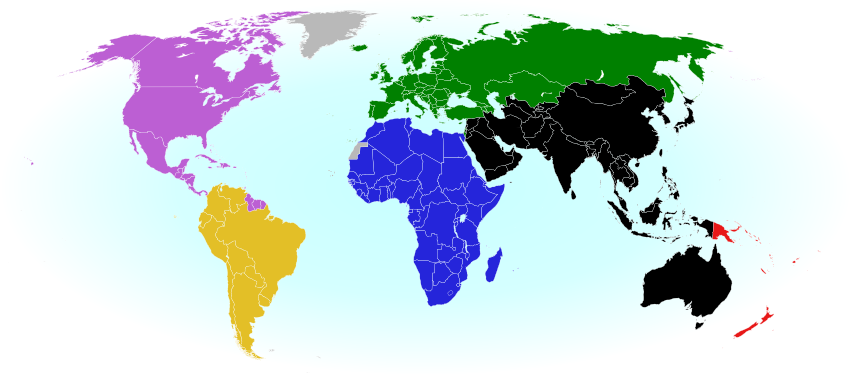
The six continental confederations of national football teams associated with FIFA. Not all confederation members are individually members of FIFA. Map by Evan Centanni, based on work by EOZyo (source).

Football/soccer fans around the world are tuning in tonight for the beginning of the month-long FIFA World Cup in Brazil. But how much do you know about which teams can compete? Which countries were eligible to enter the tournament, and which are excluded? Read on for an exclusive guide to the roster of FIFA national football teams…

Premium members click here to view this article in the ad-free members area. Not a member yet? Subscribe now!

How many countries participate in FIFA?
There are currently 209 national football teams with official FIFA membership, which is required to compete for qualification in the World Cup. FIFA members are divided into six continental confederations that preside over competitions within each region (see map above).*

You might have noticed that 209 is more than the number of actual independent countries in the world. After all, the United Nations only recognizes 195. That’s because, much like the Olympics, FIFA used to allow dependent territories to apply for membership. Now they only admit recognized independent countries (with a few exceptions), but teams that became members in the past are allowed to stay on regardless of their sovereignty status.

FIFA members that aren’t independent countries
Today there are 18 dependent territories with FIFA-eligible national football teams:

World map marking dependent territories, partially recognized sovereign states, and subnational entities which have national football (soccer) teams recognized by FIFA, making them eligible for the World Cup.
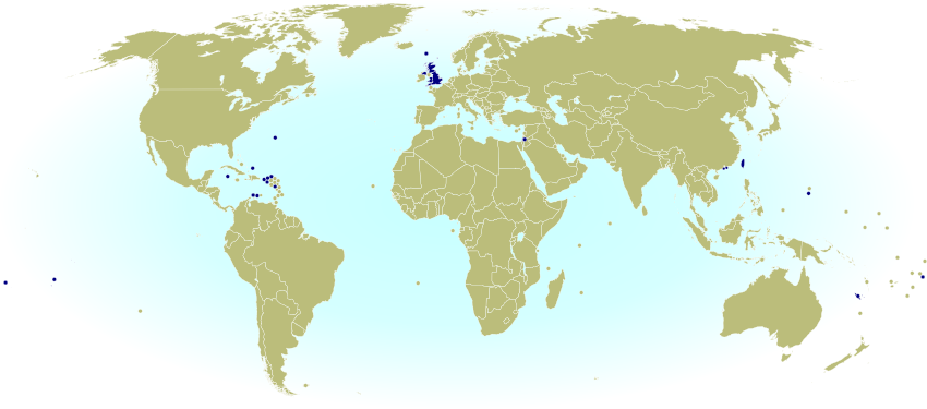
Click to enlarge: FIFA members that aren’t independent countries. By Evan Centanni, from public domain base map (source).

North America & the Caribbean
 Anguilla (UK)
 Aruba (Netherlands)
 Bermuda (UK)
 British Virgin Islands (UK)
 Cayman Islands (UK)
 Curaçao (Netherlands)
 Montserrat (UK)
 Puerto Rico (US)
 Turks and Caicos Islands (UK)
U.S. Virgin Islands (US)

Asia
 Guam (US)*
 Hong Kong (China)
 Macau (China)

Europe
 Faroe Islands (Denmark)

Oceania
 American Samoa (US)
 Cook Islands (New Zealand)
 New Caledonia (France)
 Tahiti (France)

By tradition, each of the four “countries” making up the UK also has a separate team, despite them not being independent themselves:

 England
 Northern Ireland
 Scotland
 Wales

Also as in the Olympics, disputed states Palestine and Taiwan (known in sports as “Chinese Taipei“) are included as special cases without the requirement for fully-recognized independence. In fact, Palestine is now treated as an independent country by the UN, but that wasn’t yet the case when it was first admitted to FIFA in 1998.

Changes since 2010
Since the last World Cup in 2010, one new country has joined FIFA: South Sudan. This East African nation only became independent in 2011, after the 2010 World Cup in South Africa was already over. It’s now fully eligible, but still wasn’t able to enter in this year’s Cup because qualification matches began just before it joined.

Meanwhile, the Netherlands Antilles were eligible for the last time in 2010, though they didn’t manage to qualify for the World Cup finals. Later that same year, the Dutch dependency was split into several separate territories, and its FIFA membership was inherited only by the largest island, Curaçao, which entered for the 2014 Cup but again didn’t qualify. Two of the other island territories, Bonaire and Sint Maarten, formed their own national teams but have not been accepted as FIFA members. However, they have been allowed to participate in their relevant continental organization, the Confederation of North, Central American and Caribbean Association Football (CONCACAF).

Which countries aren’t members of FIFA?
Even though quite a few dependent territories are FIFA members, there are still a few fully independent countries that aren’t eligible:

World map marking countries and dependent territories that aren't members of FIFA, and are thus ineligible to qualify for the World Cup
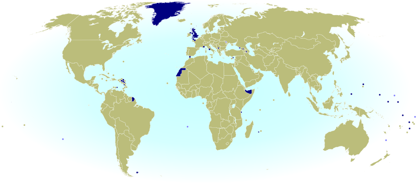
Click to enlarge: Countries and territories without FIFA membership. Dark Blue: national team not recognized by FIFA; Light Blue: no known national team. Map by Evan Centanni, from public domain base map (source).

Europe
  Monaco
 United Kingdom (UK)
   Vatican City

Oceania
 Kiribati
 Marshall Islands
 Micronesia
 Nauru
 Palau
 Tuvalu

The Marshall Islands are the only independent, UN-recognized country that don’t have any national team at all. All the others on the list do have teams (yes, even Vatican City!), but are not members of FIFA. This means they’re not eligible even to enter into qualifying matches for the World Cup, though Kiribati and Tuvalu do participate as associate members in the relevant continental organization, the Oceania Football Confederation (OFC).

Even though Palestine and Taiwan managed to secure membership, other partially unrecognized countries haven’t been able to get into FIFA. There are seven non-FIFA teams belonging to de facto independent countries:

 Abkhazia
 Kosovo
 Nagorno-Karabakh
 Northern Cyprus
 Somaliland
 South Ossetia
 Western Sahara

Another unrecognized breakaway state, Transnistria, doesn’t have a national team.

Finally, there are many dependent territories that have never been able to get into FIFA. Of these, eleven territories or country subdivisions have full or associate membership in the continental confederations, but not in FIFA itself:

Africa
 Réunion (France)
 Zanzibar (Tanzania)

North America and the Caribbean
 Bonaire (Netherlands)
 French Guiana (France)*
 Guadeloupe (France)
 Martinique (France)
 Saint-Martin (France)
 Sint Maarten (Netherlands)

Asia
 Northern Mariana Islands (US)*

Europe
 Gibraltar (UK)

Oceania
 Niue (New Zealand)

Which countries qualified for the 2014 FIFA World Cup in Brazil?
Even if a country is an eligible FIFA member, it still has to compete in the pre-tournament qualification process before moving on to the actual World Cup. Out of the 208 countries eligible at the time of qualification (remember, South Sudan missed out), there are just 32 countries qualifying for this year’s World Cup finals in Brazil. One of them, Bosnia and Herzegovina, is in the finals for the first time after gaining independence from Yugoslavia in 1992. See below for a full map of eligible and qualifying national teams in this year’s Cup:

Map of which countries qualified for the 2014 FIFA World Cup in Brazil, as well as which countries were eliminated in the qualifying rounds and which didn't enter at all.
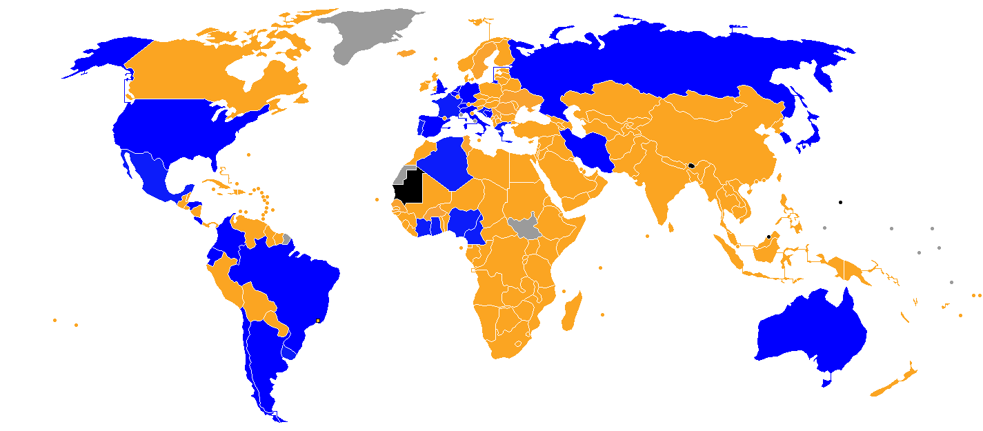
Blue = countries qualifying for the 2014 FIFA World Cup; orange = countries eliminated in the qualifying rounds; black = countries that didn’t enter; gray = countries that weren’t members when qualification began. Map by Jlsa and IgorMagic (source; CC BY-SA).

Enjoy the matches!


Note
*The six continental football confederations are based on the geographical borders of the world’s continents, but there are some exceptions. The Asian Football Confederation also includes Australia, Guam, and the Northern Mariana Islands (usually considered part of Oceania), while Caribbean countries, including South America’s Guyana, Suriname, and French Guiana, are grouped with North and Central America. As in the Olympics, Israel is a member of the European confederation despite its location on the Asian continent. Turkey, Kazakhstan, Armenia, Azerbaijan, and Georgia are also grouped with Europe but located mostly in Asia.

Palestine: West Bank and Gaza Reunited Under Transitional Government

(Keep up with changes to Palestine’s situation: view all Palestine updates.)

Map of the State of Palestine in the West Bank and Gaza Strip, including both its claimed borders (the Green Line) and zones of actual control (Areas A, B, and C from the Oslo Accords)
Control zones based on the Oslo Accords. Area A: Palestinian control; Area B: mixed Israeli-Palestinian control; Area C: full Israeli control. Map by Evan Centanni (sources: Natural Earth, B’Tselem, U.N. OCHA oPt).

Premium members click here to view this article in the ad-free members area. Not a member yet? Subscribe now!

By Evan Centanni

Unity Government
The partially-unrecognized State of Palestine is not only divided between Palestinian and Israel control – even the Palestinian-administered areas have been governed separately for several years now. However, this month rival parties Hamas and Fatah have finally come together to reunite the West Bank and Gaza Strip under a single Palestinian government.

Divided Country
The rift in control opened up in 2007, after religious militant group Hamas won a majority of seats in the 2006 Palestinian legislative elections. Hamas and Fatah, the current ruling party at the time, failed to form a stable unity government then, and the conflict between them escalated into a short civil war in the Gaza Strip. 

See Also: Is Palestine Really a Country?

The fighting ended with Hamas expelling Fatah’s administration from Gaza, while Fatah in turn refused to seat Hamas members to the government in Ramallah. This standoff has persisted for nearly seven years, with the West Bank and Gaza controlled separately by the two rival parties. Though both parties supported Palestine’s successful bid for recognition in the UN, the two regions have been administered completely separately since 2007.

Flag of the State of Palestine Country Name:  
• Palestine (English)
Filasṭīn (Arabic)
Official Name:  
• State of Palestine (English)
• Dawlat Filasṭin (Arabic)
Capital: 
• Jerusalem (claimed)
Ramallah (administrative)

Reunification
One week ago, Hamas and Fatah finally came together to form a Palestinian Authority (PA) government that includes both parties. This new administration will have jurisdiction over both the Gaza Strip and Palestinian-controlled areas of the West Bank, making it responsible for domestic affairs all across the claimed State of Palestine. Foreign relations (and relations with Israel) are handled instead by the Palestinian Liberation Organization (PLO), which has been around since before the PA was created in the 1990s by the Oslo Accords.

The current agreement also does not cover whether PA security forces will be allowed into Gaza, whose security has been handled directly by Hamas since 2007. So for the time being, the two areas may remain separate in at least that regard.

Palestine’s new unity administration is facing strong opposition from the Israeli government (which refuses to negotiate with Hamas), but has gained acceptance by much of the world. The UN, the European Union (EU), and China have all signaled their willingness to work with the new PA administration. Even the US has come on board, despite having rejected Hamas’s 2006 election victory. Because of its hardline ideology and ongoing violence against Israel, Hamas is classified as a terrorist organization by the US government, as well as by the EU.

Joining Treaties
These events come on the tail of another development in Palestine’s political status: its entry into 15 international treaties this April. The action was taken by Mahmoud Abbas, who serves as both the President of Palestine and chairman of the PLO. Palestine’s applications to these treaties have already been accepted by the UN (which considers Palestine to be a non-member “Observer State” like Vatican City), and most of them were set to go into effect in May.

Related:
Is Palestine Really a Country?
Which Countries Recognize Palestine as Independent?
Palestine Recognized as a Country by the UN

Flag of the State of Palestine is in the public domain (source).

Iraq: Updated Map of ISIS Control (Premium)

There are newer versions of this map available. To see them, view all Iraq updates.
 

Map of territorial control in Iraq in May 2014, including cities and countryside held by the Islamic State of Iraq and al-Sham (ISIS, ISIL) as well as areas administered by the Kurdistan Region. Includes detail of towns in flashpoint provinces of Anbar and Diyala

Download PDF
buy

(Subscribe via Paypal)

This is our first update to January’s map of Al Qaeda control in Iraq. The map has been expanded to show much more detail of the ongoing campaign of control by the Islamic State of Iraq and al-Sham (ISIS), now no longer an Al Qaeda affiliate.

This map and article are exclusive premium content, available only to members or for individual purchase. Buy now (US$9.99).

 Premium map includes:

  • Territorial control in Iraq by city, color coded for government, ISIS, or Kurdistan
  • Detail of ISIS control and attempted control in small towns, including in the eastern flashpoint province of Diyala
  • Inset map with extra detail for Anbar province, where ISIS controls the most populated territory
  • Indications of estimated ISIS control/influence in the countryside
  • Article summarizing events since January, explaining the information on the map, and providing in-line links to the sources of information

Members click here to proceed to article and map

Not a member yet? Subscribe Now!

Mayotte Enters European Union

“Outermost regions” are officially part of the European Union; “overseas countries and territories” are not part of the EU itself, but have special relations with it because of their connections to member countries. New outermost region Mayotte is located in southeastern Africa. Map from Wikimedia Commons © Alexrk2 (CC BY-SA)

Premium members click here to view this article in the ad-free members area. Not a member yet? Subscribe now!

Article by Evan Centanni

EU Expands to Include Mayotte
You probably heard about Croatia joining the European Union last year, but did you know the EU expanded further this year…in Africa? The French overseas department of Mayotte, a group of islands in the Indian Ocean northwest of Madagascar, became officially part of the EU on January 1.

Mayotte’s entrance into the European Union is the result of it becoming an “overseas department” of France in March 2011. An overseas department is considered to be fully part of France, just like any other of the country’s departments (a governmental unit similar to a province or county). This means that the people are represented in the French legislature and can vote in both French and European Union elections.

Topographic map of Mayotte, an Indian Ocean island group which is part of France, and which became officially part of the European Union as well on January 1, 2014
Map of Mayotte from Wikimedia Commons © Rémi Kaupp, with elements by Sting (CC BY-SA)

A Series of Referendums
Mayotte became a French colony in 1841, after centuries of rule by East African kingdoms. Part of the Comoro Islands, an archipelago located between Madagascar and mainland Africa, the people of Mayotte were allowed a vote on the question of independence in 1974.

Independence proved very popular on the rest of the Comoro Islands, which soon became the independent Union of the Comoros (still one of the world’s nearly 200 independent countries today). Mayotte itself, however, voted against it. The majority of its people preferred to remain a French territory, and reaffirmed this with a vote of 99% against joining the independent Comoros in 1976. (The Comoros still claim Mayotte as their own, with a 1976 UN Security Council resolution in their support failing after a rare French veto).

At that time, Mayotte was an overseas territory belonging to France, but not considered part of the country itself. However, in 2000 the islands voted to enter a ten-year transition period on the way to joining France proper as an overseas department. From 2001 to 2011, Mayotte was a “departmental collectivity”, neither a normal territory nor an actual department yet. A final referendum in 2009 confirmed that it would become an overseas department in 2011.

Unofficial flag of Mayotte, used locally Name:  
• Mayotte (English, French)
Full Name:  
• Department of Mayotte (English)
• Département de Mayotte (French)
Claimants: France, Comoros
Actual Control: France
Administrative Status: Integral part of France (overseas department)
Capital: Mamoudzou
Demonym: Mahoran

Though becoming part of the EU was an expected outcome of gaining department status, Mayotte’s entry into the organization was not set to take effect until Jan. 1, 2014. The occasion of Mayotte’s entry into the EU was marked by a special visit from the flagship of the European Union Naval Force.

“Outermost Region”
Within the European Union Mayotte is now classified as an “outermost region”. This means that it’s subject to most EU laws, but may be eligible for some exceptions because of practical issues related to not actually being in Europe. For example, other French outermost regions use the euro as their currency, but don’t collect EU value-added tax (VAT) and maintain separate border controls. Mayotte is now one of two EU outermost regions located in the Indian Ocean, the other being fellow overseas department Réunion.

Graphic of the locally-used flag of Mayotte is in the public domain (source).

Syria Civil War Map: April 2014 (#12.2) (Premium)

There are newer versions of this map available. To see them, view all Syria updates.

Map of territorial control in Syria's civil war, updated for April 2014. Shows control by government, rebels, ISIS extremists, and Kurdish militias. Includes important sites of recent fighting such as Yabroud, Maloula, Kasab, Azaz, Morek, Al Bukamal, and more.

Download PDF
buy

(Subscribe via Paypal)

PolGeoNow’s popular Syria civil war control maps are back! Here’s the second of our member-exclusive premium updates. 

Developments since our previous Syria map update in January include advances by both the government and the rebels, as well as changes in territorial control for the Islamic State of Iraq and Syria (ISIS).

This map and article are exclusive premium content, available only to members or for individual purchase. Buy now (US$9.99).

Premium article includes:

  • Map of current territorial control in Syria by city, color-coded for the Assad government, rebel groups, ISIS extremists, and Kurdish militias
  • Map includes recent areas of fighting such as Yabroud, Maloula, Kasab, Azaz, Al Bukamal, and more
  • Article summarizing changes since January, with links to the sources of information

Members click here to proceed to article and map

Not a member yet? Subscribe Now!

Ukraine Map #3: Separatist Control in the East (Premium)

Updated map of control in Ukraine, as of April 16, 2014. Spotlight on control by separatists in the country's east, including armed takeovers and the claimed Donetsk People's Republic.

Download PDF
buy

(Subscribe via Paypal)

Since our previous Ukraine update ten days ago, there has been a spectacular resurgence of aggressive separatist activity in eastern Ukraine, including not only protester occupations but also armed seizures reminiscent of those that began the Crimea crisis last month.

This is an up-to-date and detailed map of pro-Russian rebel and protester control in Ukraine, including the self-proclaimed “Donetsk People’s Republic”.

This map and article are exclusive premium content, available only to members or for individual purchase. Buy now (US$5.99).

Premium article includes:

  • Ukraine control map updated for the protester occupations and armed rebel takeovers in eastern Ukraine over the past two weeks
  • Shows both protester occupations and armed takeovers, as well as which regions have declared independence
  • Includes a quick briefing on recent events, with links to the sources of information

Members click here to proceed to article and map

Not a member yet? Subscribe Now!