Parade of Nations: Which Countries Are (and Aren’t) in the Olympics? (Rio 2016)

This is an older version of our Parade of Nations article. Click here to see the newest edition!

This is an updated version of an article first published in 2012. You can also read the London 2012 and Sochi 2014 versions.

World map showing the five continental associations of National Olympic Committees, including all nations eligible for the Rio 2016 Olympic games. Labels newly recognized nations Kosovo and South Sudan.
Map of all countries in the Olympics and their regional associations. Two newest Olympic Nations labeled.
(By Evan Centanni, starting from public domain blank map and modeled after this Wikipedia map)

The 2016 Summer Olympics in Rio de Janeiro, Brazil officially open tonight, Friday, August 5th! They’ll be the first Olympics ever to be held in South America, and also the first in any Portuguese-speaking country. If that wasn’t enough, they’re also the first Summer Olympics to be held entirely in the winter!

Of course, it wouldn’t be an Olympic opening ceremony without the Parade of Nations. But how many countries are there in the games, and is everyone included? Read on for an exclusive updated guide to the roster of Olympic Nations…

How many countries are in the Olympics?

There are currently 206 recognized Olympic Nations, represented by a National Olympic Committee (NOC) in each country. The International Olympic Committee (IOC) presides over the Olympic Games themselves, and the NOCs are divided between five continental associations (see map above).[1]

If 206 countries sounds like too many, don’t worry, you’re not going crazy. The UN only recognizes 195 countries worldwide (See: How Many Countries Are There in the World?). So what gives? Well, it turns out the IOC has historically been more lax than the UN about requirements for nationhood…

Dependent Territories that are Olympic Nations

Before 1995, some dependent territories were allowed to qualify for the Olympics, and were allowed to stay even after the rules changed. Today, ten of these territories hold Olympic Nation status:

World map marking dependent territories and partially recognized countries (de facto sovereign states) that have recognized National Olympic Committees and are allowed by the IOC to participate in the Olympic Games
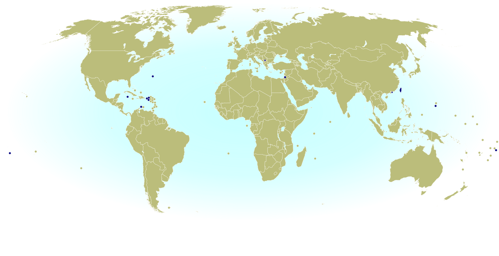
Click to enlarge: Dependent territories and partially recognized countries admitted to the Olympics.
(By Evan Centanni, from public domain base map)

Americas
 Aruba (Netherlands)
 Bermuda (UK)
 British Virgin Islands (UK)
 Cayman Islands (UK)
 Puerto Rico (US)
 Virgin Islands (US)

Asia
 Hong Kong (China)

Oceania
 American Samoa (US)
 Guam (US)
 Cook Islands (New Zealand)

Unrecognized countries that are Olympic Nations

These days, to qualify as a new Olympic Nation you have to be an “independent State recognised by the international community“. The most obvious way to meet that is to be an official member or observer state in the United Nations (UN). However, there are three non-UN countries that also participate:

 Taiwan
 Palestine
 Kosovo

Taiwan– which is claimed by China but ruled as an independent country under a pre-Communist version of the Chinese constitution – was allowed to stay after the Communist government in Beijing took over representation of Mainland China in 1979. However, a compromise deal made at the time says Taiwan has to call itself “Chinese Taipei” in the games.[2]

Disputed Palestine, whose claimed territory is largely controlled by the military of Israel, was admitted in 1995 for the sake of athletes in Gaza and the West Bank, whose residents don’t have Israeli citizenship. Palestine has since been recognized as a UN observer state, but at the time it had no UN status. However, it had already been recognized individually by about 100 of the world’s countries (more than half of the UN’s members).

The third non-UN country in the Olympics, Kosovo, is a new addition. A separatist state that controversially declared independence from Serbia eight years ago, Kosovo has never been allowed into the UN due to objections from Serbia, Russia, and others. But the IOC decided to admit Kosovo as an Olympic Nation in 2014, after about 55% of UN member countries had recognized the breakaway state as independent.

Which countries are new to the Olympics?

There are two new Olympic Nations that have been approved since the last games: Kosovo, the disputed breakaway state mentioned above, and South Sudan, which became independent and joined the UN in 2011. At the time of the 2008 and 2014 Olympics, South Sudan’s sports world wasn’t organized enough to even apply to join the IOC, but it finally got things together and was approved as an Olympic Nation in summer of 2015.

Although not an actual “nation”, there will be one other new national-level team attending Rio 2016: the Refugee Olympic Team. This team was put together by the IOC in honor of the record-high number of people in the world who have been forced to leave their home countries to escape wars. Its 10 hand-selected athletes, all of whom are refugees themselves, will have their own place in the Parade of Nations at the opening ceremony.

The last Olympic Games that had new countries were the 2008 Summer Olympics in Beijing, where the Marshall Islands, Montenegro, and Tuvalu were added to the list. There were no new Olympic Nations approved between then and the 2012 Summer Olympics in London, nor in time for the 2014 Winter Games in Sochi, Russia.

Read more:
New Olympic Nation: South Sudan
Kosovo becomes an Olympic Nation

Which countries aren’t included in the Olympics?

Despite the inclusive and worldwide mission of the Olympic Games, not all applicant countries have been allowed in. In fact, one UN-recognized country still hasn’t joined: UN observer Vatican City, the independent Catholic Church headquarters in Rome, has never applied.

The ten dependent territories allowed to participate in the Olympics are only a select few, leaving most of the world’s overseas dependencies without their own teams (though athletes from the territories are allowed to apply for their patron countries’ teams). Meanwhile, partially recognized or unrecognized countries aren’t usually admitted either, even if they’re effectively independent. In fact, there are quite a few National Olympic Committees that have been created locally but not recognized by the IOC. Here’s a partial list:

World map marking independent countries (de facto sovereign states) and dependent territories that don't have IOC-recognized National Olympic Committees, and are thus not allowed to send their own teams to the Olympics
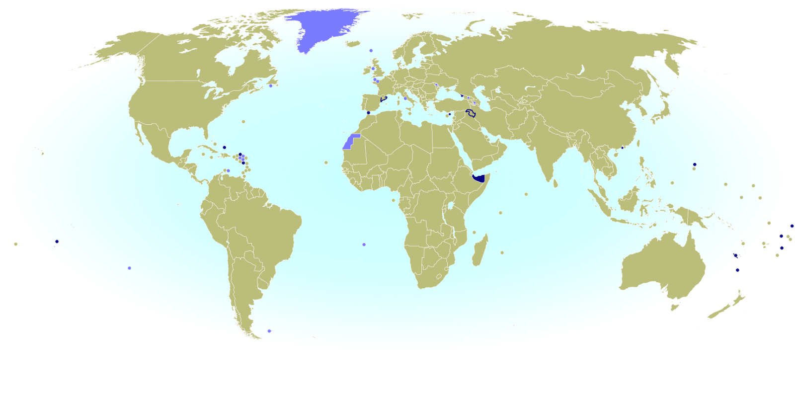
Click to enlarge: Territories and sovereign states not represented in the Olympics. Light Blue: No NOC; Dark Blue: NOC not recognized by IOC. Also shown in dark blue outlines: subnational regions with unrecognized NOCs. (By Evan Centanni, from public domain map)

Africa
 Somaliland (unrecognized country)

Americas
 Anguilla (UK territory)
 Montserrat (UK territory)
 Turks & Caicos (UK territory)

Asia
 Iraqi Kurdistan (autonomous region of Iraq)
 Macau (autonomous region of China)[3]

Europe
 Abkhazia (partially recognized country)
 Catalonia (region of Spain)
 Gibraltar (UK territory)
 Northern Cyprus (partially recognized country)

Oceania
 New Caledonia (territory of France) [4]
 Niue (associated state of New Zealand) [4]
 Norfolk Island (outlying island of Australia) [4]
 Northern Mariana Islands (US territory) [4]
 Tahiti (territory of France) [4]
 Tokelau (territory of New Zealand) [4]
 Wallis and Futuna (territory of France) [4]

Which countries are attending the Rio 2016 Olympic Games?

Being an Olympic Nation doesn’t mean you have to actually send athletes to the Olympics every time. For example, many tropical countries choose to just skip the Winter Olympics altogether. But this year, all the Olympic Nations will have athletes participating in Rio…except one.

Kuwait, which is in a drawn out dispute with the IOC over rules about government interference in sports, will not have an official team at the games. However, Kuwaiti athletes are being allowed to participate as “independent Olympic athletes”, using the Olympic flag instead of the flag of Kuwait.

That makes a total of 205 official Olympic Nations participating in the Rio 2016 games – a record high, since in London 2012 there were only 204 recognized Olympic nations in the world (and they all did attend). Add the independent Kuwaiti athletes and the new Refugee Olympic Team, and there will be a total of 207 delegations in the Parade of Nations tonight.

More Details: 2016 Parade of Nations: List of countries and flagbearers in order of entrance

Footnotes

[1] The five associations are based closely on the world’s continents, but with a few quirks: The Caucasus, Israel, and eastern Turkey are part of the European association despite geographers usually putting them in Asia; and the South American territory of French Guiana also falls under European jurisdiction, because it’s considered part of France and doesn’t have a separate team.

[2] “Chinese Taipei” is intended to be ambiguous, since most Taiwanese people consider themselves to be at least culturally Chinese. However, the use of “Taipei” is unfortunate for the two-thirds of Taiwan’s people who don’t live in or near the city of Taipei. This was especially awkward when the 2009 World Games (an Olympics-connected event) were held in Kaohsiung, Taiwan – something of a rival city to Taipei. 

[3] Although Macau’s NOC isn’t recognized by the IOC itself, it has been accepted as a member of its continental organization, the Olympic Council of Asia. Macau participates in the Asian Games and Paralympic Games, but not in the regular Olympics.

[4] Seven dependent territories in Oceania are associate members of the Oceania National Olympic Committees. They’re allowed to participate in some regionally-organized sporting events, but not in the Olympics.

Yemen Control Map & Report: August 2016 (Subscription)

MEMBERS CLICK HERE TO PROCEED TO ARTICLE AND MAP

There are newer versions of this map available. To see them, view all Yemen updates.

Map of territorial control in Yemen as of August 2, 2016, including territory held by the Houthi rebels and former president Saleh's forces, president-in-exile Hadi and his allies in the Saudi-led coalition and Southern Movement, Al Qaeda in the Arabian Peninsula (AQAP), and the so-called Islamic State (ISIS/ISIL). Includes recent locations of fighting, such as Taiz, Mukalla, Bayhan, Harad, and more.

Subscribe for full access to all conflict map reports!

Timeline by Djordje Djukic. Map by Louis Martin-Vézian, Evan Centanni, and Djordje Djukic.

In the three months since our previous Yemen map update, Houthi and pro-Hadi forces have continued to trade blows in the south and east, as well as along the border with Saudi Arabia. Meanwhile, Al Qaeda and the so-called “Islamic State” (ISIS/ISIL) have launched attacks in southern cities.


See all this and more on the newest update to PolGeoNow’s Yemen territorial control map, which includes a timeline of changes and important events since our previous Yemen map report in February.

This map and report are premium professional content, available to paid subscribers of the PolGeoNow Conflict Mapping Service.

Want to see before you buy? Check out our most recent FREE SAMPLE Yemen map report!

Exclusive report includes:

  • Up-to-date map of current territorial control in Yemen, color-coded for the pro-Hadi coalition, Houthi/Saleh forces, Al Qaeda in the Arabian Peninsula (AQAP), and the so-called “Islamic State” (ISIS/ISIL).
  • Color scheme now consistent with Syria, Iraq, and Libya map series
  • Detailed indication of town-by-town control, including provincial boundaries, all major cities, and many smaller ones
  • Markers for recent areas of fighting, including Taiz, Mukalla, Bayhan, Harad, and more
  • Timeline of changes to the situation since May 1, 2016, with links to sources

MEMBERS CLICK HERE TO PROCEED TO ARTICLE AND MAP

Not a member yet? Click here to learn more about our professional subscription service!

Can I purchase just this map?
This map and report are not available for automated purchase to non-subscribers. If you need access or republication rights for only this map report, contact service@polgeonow.com for options.

How Many Countries Are There in the World in 2016?

There are newer editions of this article available. To find the most recent, view all “How Many Countries in the World” updates!

This article, originally from 2011, has been revised and updated to August 2016. (Latest update: Gibraltar and Kosovo are now FIFA members.)

How many countries in the world?
A world political map published by the US government (public domain)

One of the most basic questions for map-lovers is, “How many countries are there in the world?” But anyone who replies with a simple number is leaving out part of the story. It actually depends a lot on how you define a “country”.

Here are six of the most common answers, each correct in its own way:

195 Sovereign States According to the UN
“Country” and “nation” are casual words for what political scientists call a “sovereign state”, meaning a place with its own borders and completely independent government. The question of which places count as sovereign states can be controversial, but for starters we can count all the member and observer countries of the United Nations (UN):

UN Members: 193
UN Observer States: 2
Total: 195

These countries mostly all accept each other as sovereign states, and they’re the ones you’ll see on most world maps and many lists of the world’s countries. Almost every country you’ve ever heard of is probably a member of the UN, and the two UN Observer States are Vatican City (represented by the Holy See) and Palestine. If you want to know the names of all 195, Wikipedia has a complete list.

The last addition to the list was in 2012, when Palestine became a UN Observer State, and the last time the number of full UN members changed was when South Sudan was admitted in 2011.

Note: Palestine’s status as a UN Observer State is controversial, so some lists may still only include 194 countries.

201 States With At Least Partial Recognition
Several more country candidates are left out of the UN itself, but are still officially acknowledged by at least one UN member (this kind of official acceptance is called “diplomatic recognition“). These controversial countries are usually labeled on world maps as disputed territories or special cases, if they’re on the map at all.

Map of Serbia, Kosovo, and North Kosovo
Kosovo is claimed by Serbia, but recognized as independent by over 100 countries.

UN Members: 193
UN Observer States: 2
States With Partial Recognition:
Total: 201

The six non-UN states with partial recognition are Taiwan, Western Sahara, Kosovo, South Ossetia, Abkhazia, and Northern Cyprus. All of these are claimed as parts of other countries, but aren’t actually controlled by them (at least not completely). The number of UN members recognizing them varies, from just one for Northern Cyprus to over 100 for Kosovo.

A few lists also include the Cook Islands and Niue as partially-recognized states. These two places sometimes act like independent countries, but they’re usually considered overseas territories of New Zealand, because they’ve never actually declared independence or tried to join the UN. 

204-207 De Facto Sovereign States
But wait, there’s more! Those six partially recognized countries aren’t the only breakaway states with full self-governance. There are at least three more self-declared countries that aren’t recognized by any UN members at all, but still operate independently from the countries that claim them. These are often called “de facto” sovereign states, a fancy Latin way of saying they’re independent countries in actual fact, even if not on paper.

UN Members: 193
UN Observer States: 2
States With Partial Recognition:
Unrecognized de facto Sovereign States: 3 to 6 (see below)
Total: 204 to 207

The three places most often considered de facto independent countries are Nagorno-Karabakh, Transnistria, and Somaliland. And since 2014 there are three more contenders for the list: the Islamic State, the Donetsk People’s Republic, and the Lugansk People’s Republic. But because those last three are located in active war zones and have only limited government structures, there’s some debate over whether they count even as de facto countries.

Tiny “micronations” declared by individual people usually aren’t taken seriously enough to count on the list. The closest contender would be Sealand, but it’s debatable whether this tiny “nation” really counts as having a territory, population, or government, all key ingredients for a sovereign state.

There are also many rebel-held territories (and fully self-governing areas like Puntland) that aren’t controlled by any country, but are left off the list because they don’t claim to be independent countries. They agree in principle that they’re part of another country, even though they might disagree about who should be in charge, or how the country should be governed.

206 Olympic Nations
Lots of people learn about the world’s list of countries by watching the Olympic Games every two years. If you’re one of them, you might be confused at why the Olympic Parade of Nations claims over 200 members, even though your atlas only has 195.

This is because the Olympics didn’t always require applicants to be independent countries. Dependent territories with partial self-government have sometimes been approved by the International Olympic Committee (IOC), and a couple of the partially-recognized states mentioned above have also managed this.

Olympic Nations that are UN Member States: 193
Olympic Nations that are UN Observer States: 1
Olympic Nations that are Partially-recognized States: 2
Olympic Nations that are Dependent Territories: 10
Total IOC-Recognized Olympic Nations: 206

World map showing the five continental associations of National Olympic Committees, including all nations eligible for the Olympic games
The Olympics include most of the world’s independent countries, and some dependent territories too.

About half of the dependent territories in the Olympics are overseas possessions of the US (such as Puerto Rico) and of the UK (such as Bermuda). Some nearly-independent “countries” such as the Cook Islands (New Zealand) and Aruba (the Netherlands) are included as well.

Every UN member country is also in the Olympics, with the latest addition, South Sudan, joining in August 2015.  The one UN Observer State in the Olympics is Palestine; Vatican City isn’t interested. As for the two partially-recognized countries in the games, Kosovo just became an Olympic Nation in 2014, and Taiwan has been a member for some time, but has to call itself  “Chinese Taipei” after a deal struck with China in the 1980s.

See Also: Parade of Nations: Which Countries Are (and Aren’t) in the Olympics

211 FIFA Countries Eligible for the World Cup
Soccer, or football as it’s known in much of the world, is the world’s most popular sport, and most international matches all the way up to the World Cup are regulated by an organization called FIFA. If you’re a soccer superfan, you might know that until recently there were 209 member countries that compete in FIFA matches (though most don’t make it to the World Cup). This is already more than the number of Olympic Nations, and certainly more than the number of independent countries on most world maps.

Like the Olympics, FIFA didn’t always require independence or international recognition of its member states. Now it’s a bit stricter, but any team that’s already a member is allowed to stay. And since May 2016, there are now two more FIFA members: Kosovo, a partially-recognized country that was voted in after being recognized by more than half of the UN’s members; and Gibraltar, an overseas territory of the UK that recently got a court order allowing it in despite not being independent.

Based on European tradition, FIFA also allows England, Scotland, Wales, and Northern Ireland to compete as separate teams, even though they’re all part of the UK.

World map marking dependent territories, partially recognized sovereign states, and subnational entities that have national football (soccer) teams recognized by FIFA, making them eligible for the World Cup.
Map from 2014 of FIFA members that aren’t recognized as independent countries by the UN

Teams of UN Member States: 186
Teams of UN Observer States: 1
Teams of Partially Recognized States: 2
Teams of UK Constituent Countries: 4
Teams of Dependent Territories: 18
Total FIFA Member Associations: 211

You might notice that not all the 193 UN member states are included. That’s because several very small countries aren’t members, plus the UK is replaced by its four “constituent countries”, which aren’t UN members on their own.

See Also: Which Countries Are (and Aren’t) Part of FIFA? (2014)

249 Country Codes in the ISO Standard List
Have you ever been filling out an internet form, and had to choose from a surprisingly long list of countries? You were probably looking at the international standard “country code” list, officially known as ISO 3166-1. Many companies and other organizations adopt this standard list rather than spending their own time compiling one. The standard also includes convenient two-letter codes for each country, like us for the United States, de for Germany, and jp for Japan, which you might recognize from web addresses specific to those countries.

This ISO standard is based on an official list kept by the UN….but then why on Earth are there 249 country codes? That’s way more than the total number of UN member and observer countries! Well, the standard list does leave out some breakaway states not recognized by the UN, but makes up for it by listing dependent territories separately from their parent countries. So there are country codes not only for actual countries, but also for nearly-independent states, overseas territories, uninhabited islands, and even Antarctica! This is important because organizations might need an option for every place that any person can be located, and dependent territories often aren’t technically part of the countries they belong to.

UN Members: 193
UN Observer States: 2
States With Partial Recognition:
Inhabited Dependent Territories: 45
Uninhabited Territories: 6
Antarctica: 1
Total: 249

So there you have it! Next time someone tells you “There are X countries in the world,” remember that the real answer isn’t so simple!

Map: Liberia and Afghanistan Join WTO

(Subscribers click here to view this article in the members area.)

Map of World Trade Organization (WTO) member and observer countries, updated for August 2016 to include new members Liberia and Afghanistan (labeled). Color blind accessible.
Map by Evan Centanni, from public domain blank map.

Additional reporting by Caleb Centanni

Two New WTO Member Countries

This month two more countries are joining the World Trade Organization (WTO), a global body founded in 1995 to promote the management and expansion of international trade. Liberia officially became the WTO’s 163rd member on July 14, and Afghanistan joins the list as member number 164 on July 29. The last new member to join the WTO was Kazakhstan in November of last year.

Joining the WTO requires a country to sign onto a set of free trade treaties managed by the organization, and to change its laws to follow the WTO’s rules for free market trade. In return, each member country gets access to cheaper trade with all the other members, who aren’t allowed to play favorites when deciding whose imports to tax or not tax.

Logo of the World Trade Organization (WTO) Organization Name:  
• World Trade Organization (English)
• Organisation mondiale du commerce (French)
• Organización Mundial del Comercio (Spanish)
Founded: 1994 in Marrakech, Morocco (commenced in 1995)
Headquarters: Geneva, Switzerland
Website: www.wto.org

A diverse West African nation, Liberia declared independence in 1847, making it the oldest continuously independent country in Africa today. Liberia’s admission to the WTO comes after almost 10 years of negotiation, getting official approval to join in December 2015 and submitting its ratified acceptance of membership on June 14 of this year.

Afghanistan, located along the ancient Silk Road on the border of South and Central Asia, is about the 40th largest country in the world by both area and population. Afghanistan was also approved for membership last December, and submitted its ratified membership acceptance on June 29, after 11 years of negotiations.

How Many Countries are in the WTO?

Of the 195 UN-recognized countries in the world, 160 (82%) are members of the WTO. Another four members are not UN-recognized nations: China’s self-governed territories of Hong Kong and Macau, the European Union, and the disputed state of Taiwan, which participates under the name “Separate Customs Territory of Taiwan, Penghu, Kinmen and Matsu (Chinese Taipei)”.

There are also 20 WTO “observers”, down from 22 now that Liberia and Afghanistan have become full members. These countries are partially included in the organization, and have all applied for full membership (except the Holy See administration of Vatican City, which doesn’t plan to). There are only 15 UN-recognized countries that are neither members nor observers of the WTO.

Two countries, East Timor and Somalia, submitted membership applications last year, but don’t yet have WTO observer status.

More: View all articles on new WTO member countries since 2011

WTO logo is displayed without permission, based on fair use principles (source).

Syrian Civil War Control Map & Report: July 2016 (Subscription)

MEMBERS CLICK HERE TO PROCEED TO ARTICLE AND MAP

There are newer versions of this map available. To see them, view all Syria updates.

Research by Djordje Djukic. Map by onestopmap.com, Evan Centanni, and Djordje Djukic

Subscribe for full access to all conflict map reports!


Map of fighting and territorial control in Syria's Civil War (Free Syrian Army rebels, Kurdish YPG, Syrian Democratic Forces (SDF), Al-Nusra Front, Islamic State (ISIS/ISIL), and others), updated for July 2016. Now includes terrain and major roads (highways). Highlights recent locations of conflict and territorial control changes, such as Manbij, Abu Kamal (Al Bukamal), Aleppo, Daraya, Kinsabba and more (color blind accessible). The past month has seen territorial gains both for Syria’s Assad government and for rebel forces, while the so-called “Islamic State” (ISIS/ISIL) has mostly held its ground.
 
See all this and more on the latest update to PolGeoNow’s concise, professional Syrian Civil War control map, which includes a timeline of changes since our previous Syria map report in late June, with sources cited.

This map and report are premium professional content, available to paid subscribers of the PolGeoNow Conflict Mapping Service.

Want to see before you subscribe? Check out our most recent FREE SAMPLE Syria map!

Exclusive map report includes:

  • Up-to-date map of current territorial control in Syria, color-coded for the Assad government, rebel groups, “Islamic State” (ISIS/ISIL) fighters, and Kurdish/SDF forces (color blind accessible).
  • Special symbols indicating towns dominated by rebels of Al Qaeda affiliate Jabhat al-Nusra (the Nusra Front) and US-backed Syrian Democratic Forces (SDF).
  • Detailed indication of city-by-city control, highlighting key towns and other locations important to current events.
  • Locations of recent fighting and military operations, including Manbij, Abu Kamal (Al Bukamal), Daraya, Kinsabba, and more.
  • Detailed timeline of important events and changes to territorial control since June 26, 2016, compiled by our Syria-Iraq expert, with links to sources.

MEMBERS CLICK HERE TO PROCEED TO ARTICLE AND MAP

Not a member yet? Click here to learn more about our professional subscription service!

Can I purchase just this map?
This map and report are not available for automated purchase to non-subscribers. If you need access or republication rights for only this map report, contact service@polgeonow.com for options.

Iraq Control Map & Report: July 2016 (Subscription)

MEMBERS CLICK HERE TO PROCEED TO ARTICLE AND MAP

There are newer versions of this map available. To see them, view all Iraq updates.

Research by Djordje Djukic. Map by onestopmap.com, Evan Centanni, and Djordje Djukic

Subscribe for full access to all conflict map reports!


Detailed map of territorial control in Iraq as of June 30, 2016, including territory held by the so-called Islamic State (ISIS, ISIL), the Baghdad government, and the Kurdistan Peshmerga. Includes recent flashpoints such as Fallujah, Karma, Saqlawiyah, and Akashat. (color blind accessible) The Iraqi army and allies have driven the so-called “Islamic State” (ISIS/ISIL) out of Fallujah, its last stronghold in central Iraq, even as it continues to lose ground on other fronts.
 
See all this and more on the latest update to PolGeoNow’s concise, professional map of control in Iraq’s civil war, including a timeline of changes since our previous Iraq map report of May 2016.

This map and report are premium professional content, available to paid subscribers of the PolGeoNow Conflict Mapping Service.

Want to see before you subscribe? Check out our most recent FREE SAMPLE Iraq map report!

Exclusive map report includes:

  • Up-to-date map of current territorial control in Iraq, color-coded for the Iraqi government, “Islamic State” (ISIS/ISIL) extremists, and Kurdistan’s Peshmerga forces
  • Detailed indication of town-by-town control, including provincial boundaries, all major cities, and many smaller ones
  • Markers for key areas of recent fighting such as Fallujah, Karma, Saqlawiyah, and Akashat
  • Timeline of changes to the situation since mid-May, compiled by our Iraq specialist, with links to sources 
  • New since last year: Terrain shading and major highways included on map for geographic context

MEMBERS CLICK HERE TO PROCEED TO ARTICLE AND MAP

Not a member yet? Click here to learn more about our professional subscription service!

Can I purchase just this map?
This map and report are not available for automated purchase to non-subscribers. If you need access or republication rights for only this map report, contact service@polgeonow.com for options.

Map: Which Countries are in the European Union, Which Aren’t, and Which Want to Join?

The UK is preparing to quit the European Union (EU) after the 2016 “Brexit” vote. But how much do you know about the EU’s membership roster? Here’s a map and list of which countries are in the EU, which ones are trying to join, and which European countries are in neither group.

Map of the European Union, including all member countries, official candidate countries, and potential candidate countries, as of June 2016 (colorblind accessible).
The UK is still part of the EU for now, since the vote to leave hasn’t been implemented yet.
Map by Evan Centanni, from blank map by Ssolbergj. License: CC BY-SA

(Subscribers click here to view this article in the members area.)

What is the European Union?

Europe’s continental union is probably most famous to outsiders for its euro currency and Schengen free travel area. But it’s actually much more than that. After all, the UK is preparing to leave the EU, but it’s not even in the Schengen Area or euro currency zone anyway!

What unites the countries of the European Union is a set of laws that all members are required to share. Mostly these are laws about things like the economy, trade, natural resources, and immigration (a major sticking point in Britain). Some countries or territories have exemptions from certain laws, but overall, being an EU member means agreeing to follow a set of rules set out by the collaborative union government in Brussels.

The idea is that Europe can do better economically, and better guarantee basic rights and standards of living, if all the countries work together as one. Needless to say, not everyone in Europe agrees this is a good thing (or that it works), and that’s how Britain has ended up headed for the exit. But at the same time, many other countries are still scrambling to join.

Which Countries are in the European Union? (Full List of EU Members)

The European Union currently has 28 member countries. The UK is still a member for now, but is expected to leave in about two years. 

List of  EU Member Countries
 Austria
 Belgium
 Bulgaria
 Croatia
 Cyprus*
 Czech Republic
 Denmark (except the Faroe Islands and Greenland)
 Estonia
 Finland
 France (except some overseas regions and territories)
 Germany
 Greece
 Hungary
 Ireland
 Italy
 Latvia
 Lithuania
 Luxembourg
 Malta
 Netherlands (except Caribbean islands)
 Poland
 Portugal
 Romania
 Slovakia
 Slovenia
 Spain
 Sweden
 United Kingdom (UK)** (not including Jersey, Guernsey, the Isle of Man, or overseas territories except Gibraltar)

*The Republic of Cyprus holds EU membership on behalf of both southern and northern Cyprus, though the north is controlled by the unrecognized breakaway Turkish Republic of Northern Cyprus, where EU law is considered to be “suspended” until the dispute can be resolved. Two British military bases on Cyprus’s southern coast, Akrotiri and Dhekelia, are considered territories of the UK and are not part of the EU. Incidentally, it is arguable whether the whole island of Cyprus is even located in Europe, but it was allowed in on the basis of its shared cultural history (78% of the population is ethnically Greek).

**In June 2016, the UK voted to exit the EU. Though the country has already been excluded from some high-level EU meetings, it has not yet begun the legal process of leaving. Once it does, there will likely be around two years of exit negotiations before it fully separates itself from the union.

Which Countries are in Line to Join the EU?

European Union membership is open any “European” country (a fuzzily-defined concept) that can convince existing members it will meet the standards of EU membership. These include being free and democratic, respecting human rights, and having a “functioning market economy” (basically anything except total economic chaos or communism). New members also have to adopt all the EU’s laws before joining, prepare to efficiently implement new EU laws made after joining, and have the “capacity to cope” with having their economies basically merged with all the other member countries. Normally, they’re also required to plan on adopting the euro as their currency, but not right away after joining. 

List of Official EU Candidate Countries
Joining the EU requires years of negotiation with the existing member countries, and the EU has a list of official candidate countries that are working on it now.

 Albania
 Macedonia
 Montenegro
 Serbia
 Turkey

Turkey applied all the way back in 1987, but is still struggling to get approval from the existing EU members. The other candidate countries are mostly at early stages of membership negotiations, or haven’t even formally started yet. 

List of Potential EU Candidate Countries
The EU also has an official designation for “potential candidates” that haven’t been fully invited to apply yet:

 Bosnia and Herzegovina
 Kosovo

What Other European Countries Aren’t in the EU?

So which countries are left, that aren’t in the European Union and aren’t even applying for membership? There are actually quite a few. Some may hope to apply further in the future, while others have decided not to apply at all. 

List of European Countries That Aren’t EU Members, Candidates, or Potential Candidates
 Andorra
 Belarus
 Moldova
 Iceland*
 Liechtenstein
 Monaco 
 Norway*
 Russia**
 San Marino
 Switzerland*
 Ukraine
 Vatican City 

*Switzerland, Norway, and Iceland have all applied for EU membership in the past, but later suspended or withdrawn their applications

**Russia is located partially in Europe and partially in Asia, but its historical center and the majority of its population are on the European side

List of Arguably European Countries That Aren’t EU Members, Candidates, or Potential Candidates
There are some cases where it’s not clear if a country is in Europe or not. The countries of the Transcaucasia region are sometimes considered culturally European, and sit right along the most commonly-used line between the European and Asian continents (following the divide of the Caucasus Mountains). Meanwhile, Kazakhstan is rarely treated as European, but part of it also lies on the European side of the line (here following the Ural River).

 Armenia (physically on Asian side, but within Transcaucasia)
 Azerbaijan (in Transcaucasia, mostly in Asia with small parts in Europe)
 Georgia (in Transcaucasia, mostly in Asia with small parts in Europe)
 Kazakhstan (mostly in Asia, with a small part in Europe)

These lists exclude several unrecognized or partially recognized breakaway states that the European Union doesn’t even consider to be countries: Northern Cyprus, Transnistria, Abkhazia, South Ossetia, Nagorno-Karabakh, the Donetsk People’s Republic, and the Lugansk People’s Republic

The disputed Republic of Kosovo, claimed by Serbia and only recognized by 56% of the world’s countries, is generally acknowledge as a country by the EU, which is why it was allowed to become a “potential candidate” country.

Who Will Join or Leave Next?

The future is impossible to predict, but you can stay up to date on European Union membership by checking back frequently with Political Geography Now, or by signing up for email updates from the box on the right-hand side of this page! You can also view all European Union articles, or follow PolGeoNow on Twitter for even more news and facts!

Related:
Map of How Britain Voted in the Brexit Referendum
9 Geography Facts You Should Know About the Brexit and Britain’s EU Membership 
Photo Essay: British Territory Gibraltar and the Brexit Referendum

Article by Evan Centanni. Country flags and associated HTML code from Wikipedia (licensed under CC BY-SA).

Which Countries Use the Euro? (Map of the Eurozone)

This Eurozone map and explainer article have been updated to June 2016. You can also view the original version from 2014.

Map of the Eurozone (euro area), showing which countries use the euro as their currency. Includes members, pre-members (ERM II), EU non-members using the euro, and other EU countries (color blind accessible).
The Eurozone, European Union, and other countries using the euro.
Map by Evan Centanni, from blank map by Ssolbergj. License: CC BY-SA

(Subscribers click here to view this article in the members area.)

Article by Caleb Centanni, with additional content by Evan Centanni 

What is the Eurozone?
Officially called the “euro area”, the Eurozone is a nickname for the group of countries in Europe that share a single currency, called the euro. The euro currency is administered by the European Union (EU), but many countries in the EU don’t use the euro, and some countries outside the EU do use it. The European Central Bank, the governing financial body of the Eurozone, is headquartered in Frankfurt, Germany. Germany, along with eleven other EU countries, became a founding member of the Eurozone in 1999.

Since then, eight more members have joined after meeting the five necessary economic criteria. This has brought the total to nineteen members, including all but nine of the 28 European Union member countries.

Which EU Countries Don’t Use the Euro?

Map of the European Union (EU) and prospective member countries in 2016 (color blind accessible)
The EU and prospective members

One country, Denmark, is part of the European Exchange Rate Mechanism (ERM II), which ties members’ currency to the euro and is a necessary step for joining the Eurozone. However, Denmark is allowed to opt out of adopting the euro, despite its ERM II membership. All members of the European Union were required by the Maastricht Treaty of 1992 to change to the euro after meeting the criteria. However, both Denmark and the UK negotiated exceptions to the requirement later in that year. Seven other EU members are still required to adopt the euro in the future.

Which Non-EU Countries Do Use the Euro?

There are four tiny countries outside the EU – Andorra, Monaco, San Marino, and Vatican City – that have monetary agreements allowing them to use the euro as their official currency. Meanwhile, two other EU non-members, Montenegro and the disputed Republic of Kosovo, have unilaterally adopted the euro without coming to any agreement with the Central Bank. The EU has expressed its dissatisfaction with these unilateral adoptions, but the currency’s use in the two countries has gone forward anyway.

What Next for the Eurozone?
Many countries sought Eurozone membership at the beginning of the financial crisis in 2008, but most became less interested after the euro was hit by its own crisis in 2009. Meanwhile, Danish polls suggest the country is unlikely to support moving to the new currency any time soon. However, all EU members except Denmark and the UK are legally required to eventually adopt the currency.

You can stay up to date on Eurozone membership by bookmarking this article (which will be updated if anything changes), or by checking Political Geography Now for new articles about countries joining or leaving the Eurozone. You can also sign up for email updates from the box on the right-hand side of this page, or follow PolGeoNow on Twitter for even more news and facts!

Articles using versions of this map:
Lithuania Joins the Eurozone (2015)
Latvia Joins the Eurozone (2014)
 

Syrian Civil War Control Map & Report: June 2016 (Subscription)

MEMBERS CLICK HERE TO PROCEED TO ARTICLE AND MAP

There are newer versions of this map available. To see them, view all Syria updates.

Research by Djordje Djukic. Map by onestopmap.com, Evan Centanni, and Djordje Djukic

Subscribe for full access to all conflict map reports!


Map of fighting and territorial control in Syria's Civil War (Free Syrian Army rebels, Kurdish YPG, Syrian Democratic Forces (SDF), Al-Nusra Front, Islamic State (ISIS/ISIL), and others), updated for June 2016. Now includes terrain and major roads (highways). Highlights recent locations of conflict and territorial control changes, such as Manbij, Mare, Tanf border crossing, Thawra/Tabqa, Arak, and more. A lot has happened in Syria in the past month, with major SDF and Syrian Army advances against the so-called “Islamic State” (ISIS/ISIL), as well as various smaller changes to rebel control.
 
See all this and more on the latest update to PolGeoNow’s concise, professional Syrian Civil War control map, which includes a timeline of changes since our previous Syria map report in mid-May.

This map and report are premium professional content, available to paid subscribers of the PolGeoNow Conflict Mapping Service.

Want to see before you subscribe? Check out our most recent FREE SAMPLE Syria map!

Exclusive map report includes:

  • Up-to-date map of current territorial control in Syria, color-coded for the Assad government, rebel groups, “Islamic State” (ISIS/ISIL) extremists, and Kurdish/SDF forces. 
  • Special symbols indicating towns dominated by rebels of Al Qaeda affiliate Jabhat al-Nusra (the Nusra Front) and US-backed Syrian Democratic Forces (SDF).
  • Detailed indication of city-by-city control, highlighting key towns and other locations important to current events.
  • Locations of recent fighting and military operations, including Manbij, Thawra (Tabqa), Mare, Tanf border crossing, Arak, and more.
  • Detailed timeline of important events and changes to territorial control since May 13, 2016, compiled by our Syria-Iraq expert, with links to sources.

MEMBERS CLICK HERE TO PROCEED TO ARTICLE AND MAP

Not a member yet? Click here to learn more about our professional subscription service!

Can I purchase just this map?
This map and report are not available for automated purchase to non-subscribers. If you need access or republication rights for only this map report, contact service@polgeonow.com for options.

UK Votes to Quit EU: Map of How Britain Voted in the Brexit Referendum

(Subscribers click here to view this article in the members area.)

By Evan Centanni

UK Brexit vote map: Map of election results in Britain's June 2016 referendum on leaving the European Union (EU). Continuous red-to-blue color scheme gives a more honest depiction of the similarities between different election districts. Colorblind accessible.
Map of election results in the UK’s “Brexit” referendum. Modified by Evan Centanni from Wikimedia map by Mirrorme22, Nilfanion, TUBS, and Sting (CC BY-SA).

UK Votes to Quit EU
The results are in for yesterday’s referendum on UK membership in the European Union, and the winner is “Leave”. Brits voted by a margin of 52% to 48% in favor of exiting the European Union, making a “Brexit” (British exit from the EU) more or less guaranteed in the coming years. Britain will become the first member country ever to leave the EU, and the British overseas territory of Gibraltar is expected to get pulled out with it.

Learn More: Brexit: 9 Geography Facts You Should Know About the Referendum and Britain’s EU Membership

Who Voted to Stay
Voter tendencies varied a lot from place to place. Support for the “Remain” side was strong across Scotland, culturally Irish parts of Northern Ireland, the London area, and a handful of other cities in England (led by Cambridge, Oxford, and Brighton).

By far the greatest show of support for Remain was a win by 96% in Gibraltar – which isn’t even in the UK proper, but got to vote because of its unique status as a British external territory that’s in the EU.

Photo Essay: Gibraltar and the Brexit Referendum

Gold: Districts with over 50% for Remain
Blue: Districts with over 50% for Leave
Map from Wikimedia Commons (click for more info)

Who Voted to Leave
The “Leave” vote, on the other hand, was strongest in eastern England, with substantial support from all across England, Wales, and the most ethnically British parts of Northern Ireland. The vast majority of the UK’s population lives in England, and this was enough to carry the referendum.

The district with the highest support for Leave was Boston, England, where 76% of voters favored leaving the EU

England, Wales, Scotland, and Northern Ireland
Taking the UK’s “constituent countries” as wholes, England and Wales each voted 53% for Leave vs. 47% for Remain, while Scotland supported Remain by 62% to 38%, and Northern Ireland supported Remain by 56% to 44%.

Scotland was the most consistently supportive of Remain, with every district at least 50% in favor of staying in the EU. England, Wales, and Northern Ireland all had some districts that went each way, though Northern Ireland was probably the most geographically divided, with 7 districts favoring Leave, and 11 favoring Remain.