“Islamic State” in the Philippines? Detailed Control Map & Timeline of the Marawi Conflict

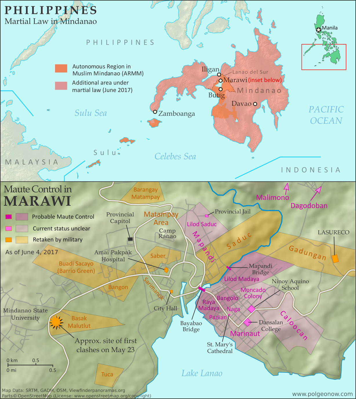
Map of so-called Islamic State (ISIS/ISIL) control in the Philippines, during the May-June 2017 crisis involving the Maute group and Abu Sayyaf takeover of Marawi Ciy, Lanao del Sur province, Mindanao. Updated to June 4, 2017, shows detailed control of Marawi by barangay. Includes map of area affected by martial law declared by President Rodrigo Duterte. Colorblind accessible.
Map by Evan Centanni. All rights reserved.

Article by Evan Centanni

(Subscribers click here to view this article in the members area.)

Rebellion in the Southern Philippines

For the past week and a half, headlines have chronicled an alleged new front in the war against the so-called “Islamic State” (IS; formerly ISIS/ISIL). A recently-formed armed organization known as the Maute group (after the family name of the two brothers who lead it) has launched a rebellion in Marawi, capital of Lanao del Sur province of the southern Philippines, apparently allying with elements of the older Abu Sayyaf organization to spread the vision of IS into southeast Asia. Marawi is a historic center for Muslim culture in the Philippines, and the largest city in the country’s partially self-governed Autonomous Region in Muslim Mindanao (ARMM).
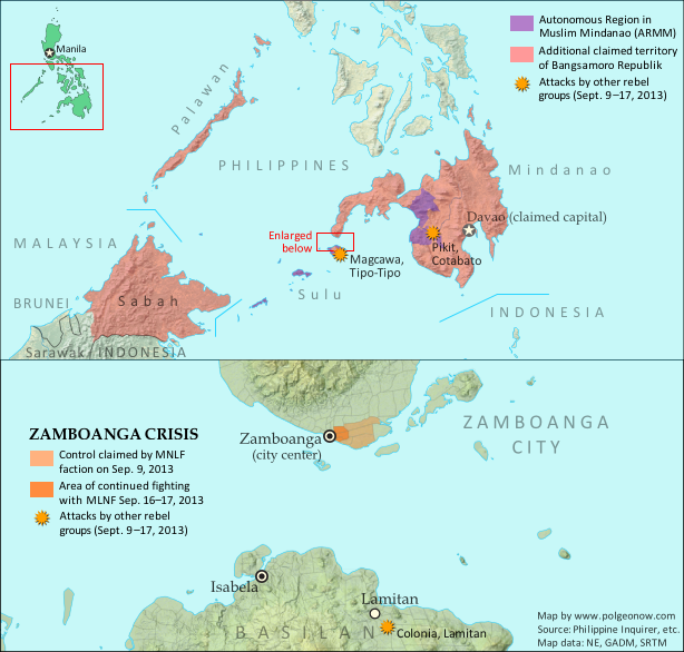
Map of territory in the Philippines and Malaysia claimed by the separatist Bangsamoro Republik, plus territorial control by the Moro National Liberation Front (MNFL) as part of the 2013 Zamboanga crisis.

The southern Philippines has a long tradition of rebellions led by members of the minority Moro ethnic group, whose main difference from the rest of Filipinos is that they’re Muslims rather than Christians. But different armed groups vary widely in their goals. Some, like the MNLF group that declared an independent “Bangsamoro Republik” in 2013, just want increased self-governance for the Moro people, without necessarily involving religion in government.

Others, like the Moro Islamic Liberation Front (MILF) – currently waiting for the Philippine government to approve a 2014 peace deal that would convert the ARMM into a more self-governed “Bangsamoro” region – are more religiously-oriented, but still support democracy.

Abu Sayyaf and the Maute group, on the other hand, are religious hardliners, who believe in the far-right ideologies of violent Salafi Muslim groups like Al Qaeda and IS. According to media in the Philippines, the Maute brothers call their organization “Dawlah Islamiyah” (Arabic for “Islamic State”), and have pledged allegiance to the leadership of the Islamic State organization in Iraq and Syria. Meanwhile, they appear to have been working closely with Isnilon Hapilon, a leader of Abu Sayyaf who IS claims as its top representative in the Philippines.

Martial Law in Mindanao

On the first day of the violence in Marawi, citing the attacks and alleged attempts at rebellion against the government of the Philippines, President Rodrigo Duterte declared martial law across the entire Mindanao island group (roughly the southern third of the country). The declaration allows for indefinite detention of suspects without trial, and will last for 60 days unless revoked or extended by the national legislature.
Flag of the PhilippinesCountry Name:  
• Philippines (English)
• Pilipinas (Filipino)
Official Name:  
• Republic of the Philippines (English)
• Republika ng Pilipinas (Filipino)
Capital: Manila

Former president Ferdinand Marcos controversially used martial law to maintain dictatorial powers across the Philippines for 8 years starting in 1972. However, the country’s current constitution, in addition to the time limits, also doesn’t allow for the courts or legislature to be overridden under martial law. This limited type of martial law declaration was also used by President Gloria Macapagal Arroyo for one week in 2009.

President Duterte himself grew up in the Mindanao region from a young age, and before his election as president served as longtime mayor of Davao, the largest city in Mindanao and second largest in the country after greater Manila. Some of Duterte’s ancestors were reportedly Muslims from the Marawi area.

Timeline of Maute Control

The following is a timeline of territorial control and other events related to the Marawi conflict. Sources are provided as in-line links. The accuracy and truthfulness of officially-available information has been called into question regarding these events, but PolGeoNow has done our best to consult a wide range of sources and provide as accurate a story as possible.

Note: The entire Philippines is divided into neighborhood/village-level administrative units known as “barangays”. Referencing these units is a useful way of tracking events on a very local scale, but because they’re very small, can change frequently, and aren’t well documented online, there’s often confusion over the exact locations and correct names of specific barangays. Because of this, references to barangays in the media and our timeline – as well as their status and locations on the above map – won’t always be 100% accurate.

November 24 – December 1, 2016
The Maute group seized control of the town of Butig, 50 km (30 mi) south of Marawi, until being driven out by the Philippine military after six days of fighting. The military estimated there were 61 Maute fighters killed in the episode and 12 injured, while 35 Philippine soldiers also sustained injuries.

May 23, 2017
Marawi City: Around 2pm at “the lower portion of the Mindanao State University Compound” in Barangay Basak Malutlut, clashes broke out between the Philippine military and fighters of the Maute group. The military had been attempting to arrest Isnilon Hapilon, a leader of the Abu Sayyaf armed group and reputed top representative of the so-called “Islamic State” (IS) in the Philippines.

By about 3pm, fighting broke out in the Caloocan neighborhood, near the Lanao del Sur provincial police command. According to early reports, during the afternoon Maute-affiliated fighters took over “Barangays Saber, Sarimanok, Mapandi, Amai Pakpak, the area near the provincial jail, [Basak] Malutlut, and Calookan [Caloocan]”. Later reports said the fighters had seized 11 barangays: Basak Malutlut, Bangon, Saber, Tuca, Bangolo, Naga, Moncado Colony, Caloocan, Marinaut, Mapandi, and Matampay.

A humanitarian organization reported that fighters raised a black flag, of the design used by the so-called “Islamic State” (IS; formerly ISIS/ISIL) and some Al Qaeda affiliates, at the Amai Pakpak Hospital. The hospital administration later denied that the facility had been taken over, while confirming it had been the site of a scuffle between Maute fighters and police.

Marawi City Jail, City Hall, the city’s main street, and two bridges were also reportedly occupied by the attackers, while St. Mary’s Cathedral was seized and its priest and 14 church workers taken hostage. Meanwhile, the city jail, a church, Ninoy Aquino School, and Dansalan College were set on fire. The fighters reportedly released 107 inmates from the city jail and neighboring Malabang District Jail. [Editor’s note: PolGeoNow was unable to confirm a map location for the Marawi City and Malabang District Jails, which appear to be different from the provincial jail.]

Residents said many of the fighters could not speak the local Maranao language, instead conversing in tongues native to the Sulu Islands, where Abu Sayyaf is known to operate. In addition, intelligence sources later estimated that up to 10 percent of pro-Maute combatants in Marawi were foreign fighters, mostly from Malaysia, Indonesia, and Singapore, but also including “at least one Pakistani, a Saudi, a Chechen, a Yemeni, an Indian, a Moroccan and one man with a Turkish passport.”

Thousands of Marawi residents fled the city to escape the violence, as ground troops in armored personnel carriers attempted to contain the Maute fighters, and airstrikes were conducted at the shore of Lake Lanao. Police reportedly closed down all entry and exit points to Iligan City, 40 km (25 mi)  to the north.

At 10pm, Philippine Presdient Rodrigo Duterte declared martial law in the Mindano island group, cutting short a visit to Russia so he could return to the Philippines.

May 24, 2017
Fighting reportedly reached a pause, as the military held its ground while awaiting reinforcements. A humanitarian spokesperson from the regional government said the conflict-affected neighborhoods were “Barangays Basak Malutlut, Caloocan, Abubakar, and Bangolo”. [Editor’s note: There does not appear to be any barangay called “Abubakar” in Marawi.]

Marawi’s police chief and another police official were killed in confrontations, while government agencies bused fleeing civilians to three new evacuation centers in Iligan City, and the Maute group threatened to behead the priest of St. Mary’s Cathedral if the military didn’t pull out of the city. The military reported that 13 Maute fighters and 5 Philippine soldiers had been killed since the beginning of the incident. The city of 200,000 was reportedly “like a ghost town” after tens of thousands of residents fled for safety, though 800 were sheltering within Marawi at the Lanao del Sur provincial capitol building.

May 25, 2017
Army tanks and assault helicopters entered Marawi, while residents said the Maute fighters looted and burned civilian homes. A military spokesperson said that Amai Pakpak Hospital, Marawi City Hall, and Mindanao State University had been cleared of Maute fighters.

The same day, fighting was reported from Barangays Malimono, Gadungan, Bangolo, and Marinaut. The military said the heaviest fighting occurred around two bridges in Barangay Bangolo, while elsewhere in the city Maute fighters attacked the Camp Ranao army base and occupied the LASURECO electric company headquarters. Airstrikes were conducted in Barangays Gadungan, Basak Malutlut, and Bangon. 

May 26, 2017
The military announced that the death toll in the Marawi conflict had increased to 31 Maute fighters and 11 Philippine soldiers, in addition to the two police officers killed on the 24th.

May 29, 2017
The government said it was “in full control of Barangays Matampay, Basak Malulut, Barrio Green, Bangon and Saduc, the peripheries of the Mindanao State University campus and the Amai Pakpak Hospital and the Matampay area.” Major fighting occurred in Marinaut and around the LASURECO compound. The military apparently prevailed at the latter location, rescuing several hostages, and also evacuated a number of civilians from Barangay Saber.

May 30, 2017
A week after the conflict began, the military said Maute group fighters were “still present” in nine barangays. Progress in retaking the rest of the city had been slowed by Maute snipers targeting soldiers from buildings under their control. Media quoted the death toll of the Marawi conflict at 20 “members of the security forces”, 61-64 Maute fighters, and 19-24 civilians, while the Red Cross estimated that 3,000 residents were still trapped in their homes. Meanwhile, the military admitted that Maute fighters had captured an armored personnel carrier – a type of tank.

A regional news report – dated June 2 but apparently referring to the situation as of May 30-31 – listed Mindanao State University, Matampay, Saber, and Basak Malutlut as “areas declared clear” by the military. Areas not yet “cleared” included “Banggolo, Raya Madaya I and II; Lilod Madaya, Dagodoban, Padian, Barrio Naga, Marinaut West and East; Caloocan, Pangarungan, and Moncado Colony”. [Editor’s note: “Pangarungan” seems to refer to the same area also known as Barangay Moncado Colony.] Barangays Banggolo, Raya Madaya I and II, and Marinaut were also reportedly inaccessible due to airstrike damage. Over 3,000 residents were estimated to still be trapped in their homes, even after the rescue of more than 2,300, who were brought to the provincial capitol.

May 31, 2017
According to eyewitness media accounts, the Mapandi and Bayabao bridges were still under Maute control after one week, with the group inferred to control much of the town center as well. Military accounts said Maute fighters controlled only 10% of the city, with 89 members of the group killed since the start of the conflict. One military source said the fighers were confined to just four barangays: Bangolo, Lilod Madaya, Raya Madaya I, and Raya Madaya II.

Hapilon and the two Maute brothers were believed to still be in Marawi. The Marawi City Jail and Malabang District jail were reported to still be under Maute control as well, with their staff trapped inside. The military’s fatality count for the conflict rose to 120 Maute fighters and 36 soldiers, including 10 killed accidentally by a government airstrike. The official count of civilian deaths remained at 19.

June 2, 2017
Ongoing military efforts were reportedly focused on Bangolo in Marawi’s downtown. Meanwhile, military forces reportedly eliminated a Maute sniper position in Mapandi, while airstrikes continued in the area. Delays in securing control of the city were attributed to Maute snipers and use of civilians as a human shields. A military spokesperson admitted that the government would not achieve its goal of gaining complete control over Marawi by June 2.

Meanwhile, IS claimed credit for an alleged attack on a casino in the Philippine capital city of Manila, which the Philippine government insisted was actually a robbery attempt by a lone gambler – an interpretation apparently supported by video of the events. The attacker fired a weapon multiple times, but reportedly didn’t shoot anyone (except eventually himself); however, 37 people died as an apparent result of fires he started.

June 3, 2017
Though military efforts were reportedly still focused on Barangay Bangolo, civilians were also said to still be trapped in the nearby Raya Madaya neighborhood. The Philippine government said it believed the fighters had prepared in advance for their takeover attempt, and may have received assistance from IS in the Middle East. Meanwhile, the military raised the official death toll to 120 Maute members, 38 government personnel, and 20 civilians, after a resident was allegedly shot by a Maute sniper while being evacuated. The government also raised its estimate of the total remaining Maute fighters to “200 to 250” in addition to the 120 already killed, after having estimated a total of just 100 the previous week.

June 4, 2017
A four-hour humanitarian ceasefire, arranged directly with one of the Maute brothers by the Moro Islamic Liberation Front (MILF) rebel group, allowed 134 non-combatants to be evacuated from the heart of the fighting in Barangay Bangolo. The MILF, Mindanao’s most powerful rebel group, which is awaiting the completion of a peace deal with the government, has opposed the Maute takeover but not directed its forces to get involved militarily.

Meanwhile, President Duterte announced he had accepted an offer by Nur Misuari, leader of the MNLF rebel faction that took over another city in Mindanao in 2013, to send 2,000 fighters to help the government against the Maute group. The president publicly invited the communist New People’s Army (NPA), the country’s oldest active rebel group, to do the same.

Related: Map of 2013 MNLF Rebel Control in the Philippines’ Zamboanga City

Also on June 4, a humanitarian agency said over 220,000 people had fled the violence, of whom about 58,000 were staying in evacuation centers and 163,000 were living at the homes of family members. Meanwhile, a news agency released photos of the destruction caused by government airstrikes in downtown Marawi.

Following this story? To check for updates, view all Philippines articles on PolGeoNow!

Graphic of the flag of the Philippines is in the public domain (source).

Syria Control Map & Timeline: “De-escalation zones” & Continued IS Losses – May 2017 (Subscription)

SUBSCRIBERS CLICK HERE TO PROCEED TO ARTICLE AND MAP

There are newer versions of this map available. To see them, view all Syria updates.

Research by Djordje Djukic. Map by onestopmap.com, Evan Centanni, and Djordje Djukic

Subscribe for full access to all conflict map reports!


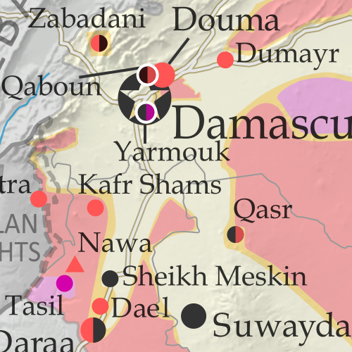
Map of fighting and territorial control in Syria's Civil War (Free Syrian Army rebels, Kurdish YPG, Syrian Democratic Forces (SDF), Jabhat Fateh al-Sham / Hayat Tahrir al-Sham (Al-Nusra Front), Islamic State (ISIS/ISIL), and others), updated to May 25, 2017, including Russia-Turkey-Iran agreed de-escalation zones and US deconfliction zones. Includes recent locations of conflict and territorial control changes, such as Qaboun, Sawwana, Shaer gas fields, Jirah airbase, and more. Colorblind accessible.The past month has seen continued territorial losses for the so-called “Islamic State” (IS; formerly, ISIS/ISIL), as government and rebel forces take vast swaths of desert and a Kurdish-led coalition closes in on the group’s capital. Meanwhile, foreign countries have begun drawing up provisional ceasefire zones along hardened lines between rebel and government control.

 See all this and more on the latest update to PolGeoNow’s concise, professional Syrian Civil War control map, which includes a timeline of changes since our previous Syria map report in April, with sources cited.

This map and report are premium professional content, available to paid subscribers of the PolGeoNow Conflict Mapping Service.

Want to see before you subscribe? Check out our most recent FREE SAMPLE Syria map!

Exclusive report includes:

  • Up-to-date map of current territorial control in Syria, color-coded for the Assad government, rebel groups, “Islamic State” (ISIS/ISIL) fighters, and Kurdish/SDF forces. Colorblind accessible.
  • Markers showing the approximate locations of Russian-Turkish-Iranian “de-escalation zones” and the one known US “deconfliction zone”.
  • Special symbols indicating towns dominated by rebels of the former Nusra Front (now Hayat Tahrir al-Sham) and US-backed Syrian Democratic Forces (SDF).
  • Detailed indication of city-by-city control, including key towns and other locations important to current events.
  • Locations of recent fighting and other important events, including Qaboun, Sawwana, Shaer gas fields, Jirah airbase, and more.
  • Detailed timeline of important events and changes to territorial control since April 26, 2017, compiled by our Syria-Iraq expert, with links to sources.

SUBSCRIBERS CLICK HERE TO PROCEED TO ARTICLE AND MAP

Not signed up yet? Click here to learn more about our professional subscription service!

Can I purchase just this map?
This map and report are not available for automated purchase to non-subscribers. If you need access or republication rights for only this map report, contact service@polgeonow.com for options.

Yemen Control Map & Report: May 2017 (Subscription)

SUBSCRIBERS CLICK HERE TO PROCEED TO ARTICLE AND MAP

There are newer versions of this map available. To see them, view all Yemen updates. 

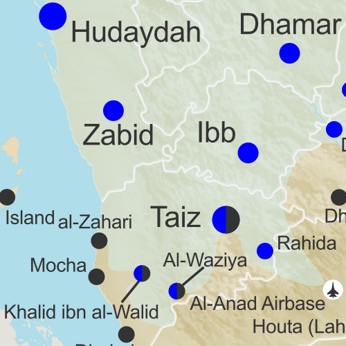
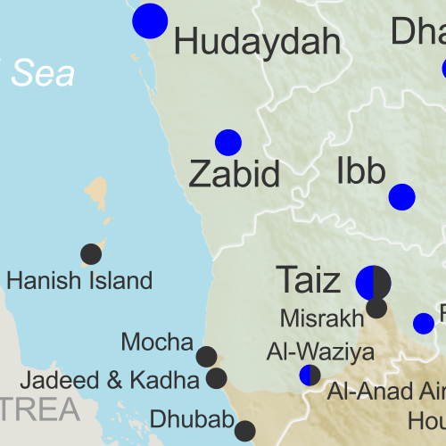
Map of what is happening in Yemen as of May 18, 2017, including territorial control for the Houthi rebels and former president Saleh's forces, president-in-exile Hadi and his allies in the Saudi-led coalition and Southern Movement, Al Qaeda in the Arabian Peninsula (AQAP), and the so-called Islamic State (ISIS/ISIL). Includes recent locations of fighting, including Mocha, Maydee, al-Zahari, Nihm, and others, including areas along the Yemen border with Saudi Arabia.

Subscribe for full access to all conflict map reports!

Timeline by Djordje Djukic. Map by Louis Martin-Vézian, Evan Centanni, and Djordje Djukic.

Since February, the Saudi-backed coalition supporting Yemen’s internationally-recognized government  has made some modest territorial gains against the Houthi government in two different areas, while Al Qaeda fighters still hold much of the country’s east.


See all this and more on the newest update to PolGeoNow’s Yemen territorial control map, which includes a timeline of changes and important events since our previous Yemen map report in late February.

This map and report are premium professional content, available to paid subscribers of the PolGeoNow Conflict Mapping Service.

Want to see before you buy? Check out our most recent FREE SAMPLE Yemen map report!

Exclusive report includes:

  • Up-to-date map of current territorial control in Yemen, color-coded for the pro-Hadi coalition, Houthi/Saleh forces, Al Qaeda in the Arabian Peninsula (AQAP), and the so-called “Islamic State” (ISIS/ISIL).
  • Detailed indication of town-by-town control, including provincial boundaries, all major cities, and many smaller ones
  • Markers for recent areas of fighting, including Mocha, Maydee, al-Zahari, Nihm, and others
  • Timeline of changes to the situation since February 22, 2017, with links to sources

SUBSCRIBERS CLICK HERE TO PROCEED TO ARTICLE AND MAP

Not a member yet? Click here to learn more about our professional subscription service!

Can I purchase just this map?
This map and report are not available for automated purchase to non-subscribers. If you need access or republication rights for only this map report, contact service@polgeonow.com for options.

Libya Control Map & Timeline – April 2017 (Subscription)

SUBSCRIBERS CLICK HERE TO PROCEED TO ARTICLE AND MAP

There are newer versions of this map available. To see them, view all Libya updates.

Research by Djordje Djukic, with Evan Centanni. Map by onestopmap.com and Evan Centanni.

Subscribe for full access to all conflict map reports!

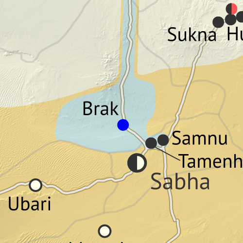
Libya control map: Shows detailed territorial control in Libya's civil war as of April 2017, including all major parties (Government of National Accord (GNA); Tobruk House of Representatives, General Haftar's Libyan National Army (LNA), Zintan militias, Petroleum Facilities Guard (PFG); Tripoli GNC government, Libya Dawn, and Libya Shield Force; Shura Council of Benghazi Revolutionaries and other hardline Islamist groups; and National Salvation Government). Now includes terrain and major roads. Colorblind accessible. After driving so-called “Islamic State” (ISIS/ISIL) fighters out of their last stronghold in Libya, clashes have gradually increased between the country’s two rival governments, even as the eastern government has continued its unilateral campaign against religious hardliners, and a new “neutral” military force has emerged with ties to the ousted leader of the previous western government.
 
See all this and more on the latest update to PolGeoNow’s concise, professional Libyan Civil War control map, which comes with a timeline of changes since our December 2016 Libya map report.

This map and report are premium content available to paid subscribers of the PolGeoNow Conflict Mapping Service.

Want to see before you subscribe? Check out our most recent FREE SAMPLE Libya map!

Exclusive report includes:

  • Up-to-date map of current territorial control in Libya, color-coded for the UN-backed Government of National Accord (GNA), the rival Tobruk parliament and Khalifa Haftar’s Libyan National Army (LNA), religious hardline groups, and other actors such as the Toubou people of the southern desert.
  • Detailed indication of city-by-city control, including key towns and other locations important to current events.
  • Locations of recent fighting and military operations, including Benghazi, Sidra oil port, the Brak and Tamenhint airbases, and more.
  • Detailed timeline of important events and changes to territorial control since December 6, 2016, with all sources cited.

SUBSCRIBERS CLICK HERE TO PROCEED TO ARTICLE AND MAP

Not signed up yet? Click here to learn more about our professional subscription service!

Can I purchase just this map?
This map and report are not available for automated purchase to non-subscribers. If you need access or republication rights for only this map report, contact service@polgeonow.com for options.

Syria Control Map & Timeline – April 2017 (Subscription)

SUBSCRIBERS CLICK HERE TO PROCEED TO ARTICLE AND MAP

There are newer versions of this map available. To see them, view all Syria updates.

Research by Djordje Djukic. Map by onestopmap.com, Evan Centanni, and Djordje Djukic

Subscribe for full access to all conflict map reports!


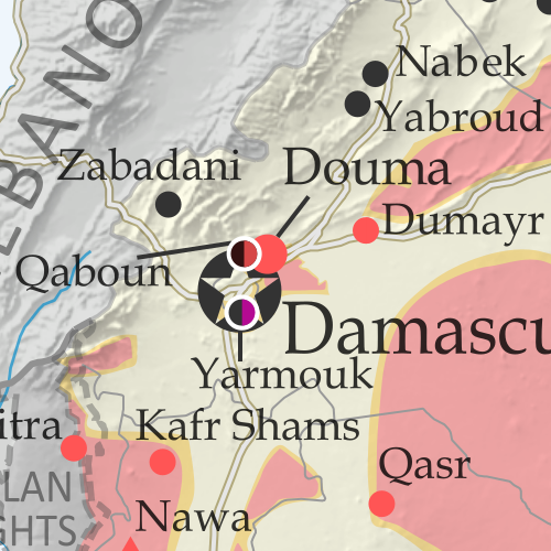
Map of fighting and territorial control in Syria's Civil War (Free Syrian Army rebels, Kurdish YPG, Syrian Democratic Forces (SDF), Jabhat Fateh al-Sham / Hayat Tahrir al-Sham (Al-Nusra Front), Islamic State (ISIS/ISIL), and others), updated to April 26, 2017. Now includes terrain and major roads (highways). Includes recent locations of conflict and territorial control changes, such as Thawra, Halfaya, Suran, Qaboun, and more. Colorblind accessible. The so-called “Islamic State” (ISIS/ISIL) has continued to lose ground in Syria to the Kurdish-led, US-backed Syrian Democratic Forces (SDF) in the north, and to rebel groups in the southern desert. Meanwhile, the Assad government has made some gains against rebels in Hama province, the Damascus area, and elsewhere.
 
See all this and more on the latest update to PolGeoNow’s concise, professional Syrian Civil War control map, which includes a timeline of changes since our previous Syria map report in March, with sources cited.

This map and report are premium professional content, available to paid subscribers of the PolGeoNow Conflict Mapping Service.

Want to see before you subscribe? Check out our most recent FREE SAMPLE Syria map!

Exclusive report includes:

  • Up-to-date map of current territorial control in Syria, color-coded for the Assad government, rebel groups, “Islamic State” (ISIS/ISIL) fighters, and Kurdish/SDF forces. Colorblind accessible.
  • Special symbols indicating towns dominated by rebels of the former Nusra Front (now Hayat Tahrir al-Sham) and US-backed Syrian Democratic Forces (SDF).
  • Detailed indication of city-by-city control, including key towns and other locations important to current events.
  • Locations of recent fighting and other important events, including Thawra, Halfaya, Suran, Qaboun, and more.
  • Detailed timeline of important events and changes to territorial control since March 29, 2017, compiled by our Syria-Iraq expert, with links to sources.

SUBSCRIBERS CLICK HERE TO PROCEED TO ARTICLE AND MAP

Not signed up yet? Click here to learn more about our professional subscription service!

Can I purchase just this map?
This map and report are not available for automated purchase to non-subscribers. If you need access or republication rights for only this map report, contact service@polgeonow.com for options.

Syria Control Map & Timeline: “Islamic State” Under Siege – March 2017 (Subscription)

SUBSCRIBERS CLICK HERE TO PROCEED TO ARTICLE AND MAP

There are newer versions of this map available. To see them, view all Syria updates.

Research by Djordje Djukic. Map by onestopmap.com, Evan Centanni, and Djordje Djukic

Subscribe for full access to all conflict map reports!


Map of fighting and territorial control in Syria's Civil War (Free Syrian Army rebels, Kurdish YPG, Syrian Democratic Forces (SDF), Jabhat Fateh al-Sham / Hayat Tahrir al-Sham (Al-Nusra Front), Islamic State (ISIS/ISIL), and others), updated to March 29, 2017. Now includes terrain and major roads (highways). Includes recent locations of conflict and territorial control changes, such as Palmyra, Dayr Hafir, Karama, Qaboun, and more. Colorblind accessible. Advances against the so-called “Islamic State” (ISIS/ISIL) have accelerated from all sides, with Kurdish-led forces nearing the doorstep of the group’s capital city. Meanwhile, months of defeats for anti-Assad rebels may have begun to reverse.
 
See all this and more on the latest update to PolGeoNow’s concise, professional Syrian Civil War control map, which includes a timeline of changes since our previous Syria map report in February, with sources cited.

This map and report are premium professional content, available to paid subscribers of the PolGeoNow Conflict Mapping Service.

Want to see before you subscribe? Check out our most recent FREE SAMPLE Syria map!

Exclusive report includes:

  • Up-to-date map of current territorial control in Syria, color-coded for the Assad government, rebel groups, “Islamic State” (ISIS/ISIL) fighters, and Kurdish/SDF forces. Colorblind accessible.
  • Special symbols indicating towns dominated by rebels of the former Nusra Front (now Hayat Tahrir al-Sham) and US-backed Syrian Democratic Forces (SDF).
  • Detailed indication of city-by-city control, including key towns and other locations important to current events.
  • Locations of recent fighting and other important events, including Palmyra, Dayr Hafir, Karama, Qaboun, and more.
  • Detailed timeline of important events and changes to territorial control since February 24, 2017, compiled by our Syria-Iraq expert, with links to sources.

SUBSCRIBERS CLICK HERE TO PROCEED TO ARTICLE AND MAP

Not signed up yet? Click here to learn more about our professional subscription service!

Can I purchase just this map?
This map and report are not available for automated purchase to non-subscribers. If you need access or republication rights for only this map report, contact service@polgeonow.com for options.

2016 Year in Review: Rebel Control Around the World

The rebel control maps in this article were produced for PolGeoNow’s professional conflict map subscription service. Full-size versions of all PolGeoNow conflict maps, along with territorial control timelines, are accessible to subscribers. You can learn more about our map subscriptions here. Non-subscribers can also view our collection of free sample control map reports.

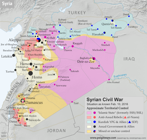
Map of fighting and territorial control in Syria's Civil War (Free Syrian Army rebels, Kurdish YPG, Syrian Democratic Forces (SDF), Al-Nusra Front, Islamic State (ISIS/ISIL), and others), updated for February 2016. Now includes terrain and major roads (highways). Highlights recent locations of conflict and territorial control changes, such as Menagh airbase, northern Aleppo, Salma, Rabia, Nubl, Baghaliya, Tishrin Dam, and more.
Syria in February 2016
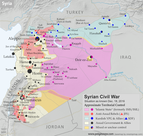
Map of fighting and territorial control in Syria's Civil War (Free Syrian Army rebels, Kurdish YPG, Syrian Democratic Forces (SDF), Jabhat Fateh al-Sham (Al-Nusra Front), Islamic State (ISIS/ISIL), and others), updated to December 18, 2016. Now includes terrain and major roads (highways). Includes recent locations of conflict and territorial control changes, such as Aleppo, Palmyra, Khan al-Shih, Mayda'ani, and more. Colorblind accessible.
Syria in December 2016

The Year in Territorial Control Changes

For the past three years, PolGeoNow has published a “Year in Review” article to summarize all the political geography news that’s happened in the past 12 months. The 2014 and 2015 articles included news about changing territorial control in conflict zones, but because this is a major topic of its own, we’ve chosen to split these events into a separate article for 2016. So read on for a concise summary of last year’s rebel control changes…

See Also: 2016 Year in Review: Country & Border Changes 
 

Syria, Iraq, and the “Islamic State”

The Syrian Civil War continued to be the biggest armed conflict in the world through 2016, as well as a prominent example of a country whose territory isn’t all controlled by the recognized government. During the past year, pro-government forces scored some major victories against the rebels, recapturing the country’s second largest city and gradually increasing control in areas around the capital.

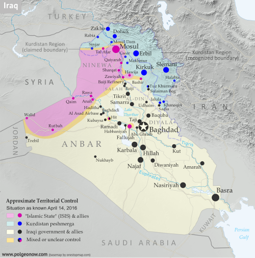
Detailed map of territorial control in Iraq's ongoing war as of April 14, 2016, including territory held by the so-called Islamic State (ISIS, ISIL), the Baghdad government, and the Kurdistan Peshmerga. Includes recent flashpoints including Ramadi, Hit, Bashir, and more.
Iraq in April 2016
Detailed map of territorial control in Iraq as of January 10, 2016, including territory held by the so-called Islamic State (ISIS, ISIL), the Baghdad government, and the Kurdistan Peshmerga. Shows developments in the ongoing coalition battle to recapture the city of Mosul. Includes key locations from recent events, such as Mosul, Al-Sagra, and Hamam al-Alil. Colorblind accessible.
Iraq in January 2017

Meanwhile, the so-called “Islamic State” (IS; formerly ISIS/ISIL) lost ground in Syria throughout the year, getting cut off from its border with Turkey by Turkish-backed rebels, and driven from important northern towns like Manbij and Shadaddi by the US-backed Syrian Democratic Forces (SDF), a coalition led by Syrian Kurdish militias. IS also lost the southern desert town of Palmyra to government forces, but recaptured it again before the end of the year.

At the other end of IS territory, in Iraq, the group also suffered territorial losses, being driven from its earliest Iraqi strongholds in Fallujah and Ramadi, while losing nearly half of its biggest city, Mosul. IS also had a disastrous year in Libya, where it fell from its greatest extent of control in early 2016 to holding no territory at all by the end of the year.

Elsewhere in the world, IS struggled to gain territorial footholds in Somalia and Yemen, but had little to show for it at the end of the year, while Nigeria’s IS affiliate – commonly known as “Boko Haram” – spent 2016 with little to no territorial control, after being decisively driven out of most of its possessions in 2015. And while IS was beginning to accumulate territory in Afghanistan a year ago, by mid-2016 it lost most of it again to government offensives and conflicts with the Taliban rebels.

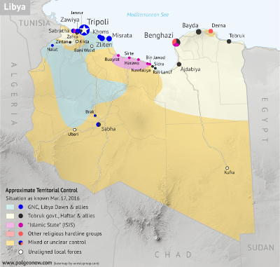
Libya control map: Shows detailed territorial control in Libya's civil war as of March 2016, including all major parties (Tobruk government, General Haftar's Operation Dignity forces, and Zintan militias; Tripoli GNC government, Libya Dawn, and Libya Shield Force; Shura Council of Benghazi Revolutionaries and other hardline Islamist groups; and the so-called Islamic State (ISIS/ISIL)). Also file under: Map of Islamic State (ISIS) control in Libya. Now includes terrain and major roads. Color blind accessible.
Libya in March 2016
Libya control map: Shows detailed territorial control in Libya's civil war as of December 2016, including all major parties (Government of National Accord (GNA); Tobruk House of Representatives, General Haftar's Libyan National Army, Zintan militias, Petroleum Facilities Guard (PFG); Tripoli GNC government, Libya Dawn, and Libya Shield Force; Shura Council of Benghazi Revolutionaries and other hardline Islamist groups; and National Salvation Government). Also file under: Map of Islamic State (ISIS or ISIL) control in Libya. Now includes terrain and major roads. Colorblind accessible.
Libya in December 2016

Other Major Conflict Zones

Meanwhile, all of the countries where IS struggled to hold ground – except for Nigeria, where other rebels’ attempts to capture land fizzled out – had bigger territorial control issues.

Libya saw a major political realignment between its two rival governments, as the internationally unrecognized administration in the west joined a new UN-backed unity government, leaving its rival in the east to lose much of its international support. Control on the ground also changed late in 2016 after a power struggle over independently-guarded oil ports on the country’s central coast.

In Afghanistan, the Taliban continued consolidating their control of rural areas, while briefly overrunning or besieging three provincial capital cities. Around the middle of the year, 20% of Afghanistan was reportedly under Taliban control.

At the same time, Somalia continued to struggle against Al Shabaab, an affiliate of Al Qaeda, which continued to control a large portion of the country’s rural south, and briefly overran some major towns in 2016.

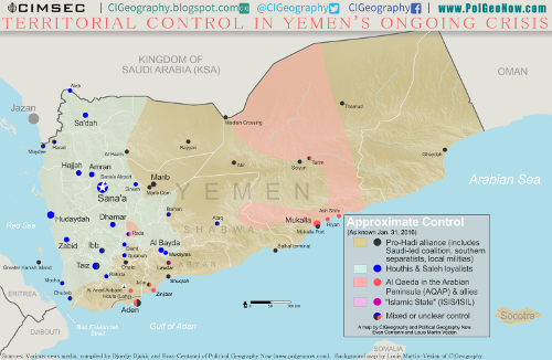
Map of territorial control in Yemen as of January 31, 2016, including territory held by the Houthi rebels and former president Saleh's forces, president-in-exile Hadi and his allies in the Saudi-led coalition and Southern Movement, Al Qaeda in the Arabian Peninsula (AQAP), and the so-called Islamic State (ISIS/ISIL). Includes recent areas of fighting, such as Aden, the Bab al-Mandeb Strait, Dhubab, Hanish Island, Harad, Maydee, Mukallah, and more.
Yemen in January 2016
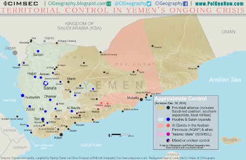
Map of what is happening in Yemen as of December 30, 2016, including territorial control for the Houthi rebels and former president Saleh's forces, president-in-exile Hadi and his allies in the Saudi-led coalition and Southern Movement, Al Qaeda in the Arabian Peninsula (AQAP), and the so-called Islamic State (ISIS/ISIL). Includes recent locations of fighting, including Al Gail, Sirwah, Usaylan, and areas long the Yemen border with Saudi Arabia. Colorblind accessible.
Yemen in December 2016

In Yemen, meanwhile, a Saudi-backed coalition nibbled slowly at the edges of the territory of the Houthi rebels now in control of the country’s capital, finding more success driving Al Qaeda forces out of several cities and towns along the country’s southern coast.

Smaller Territorial Control Changes

The ACLED conflict database catalogued heavy ongoing territorial struggles in South Sudan, Sudan, and the Democratic Republic of the Congo, a handful of small rebel seizures or losses in Mali, Myanmar, Thailand, and Mozambique, and possible incidents of rebels capturing bits of territory in Ethiopia, Uganda, and Kenya (where Al Shabaab violence sometimes spills over from neighboring Somalia). Pakistan also reportedly cleared one of its last areas thought to be held by religious hardline rebels near the border with Afghanistan.

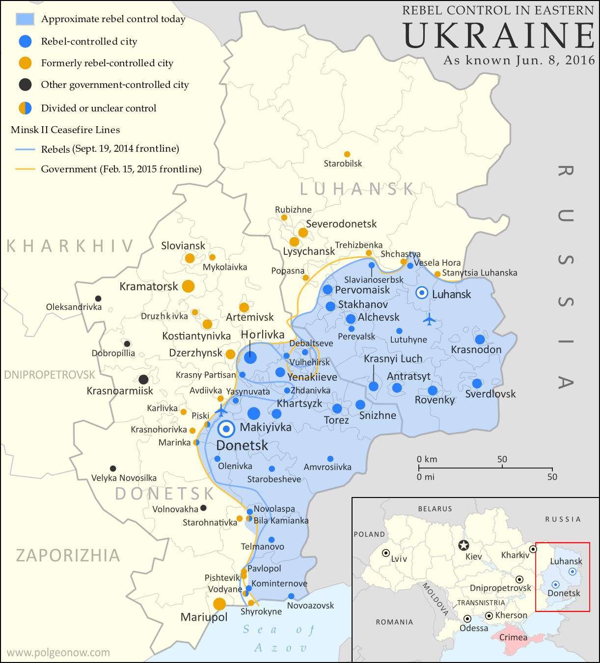
Map of rebel territorial control in Ukraine's eastern provinces of Donetsk and Luhansk, claimed by the breakaway Donetsk People's Republic and Lugansk People's Republic. Updated for June 2016, with Minsk ceasefire lines shown.

PolGeoNow also reported on some small changes to territorial control in the nearly-frozen conflict between Ukraine and the breakaway Donetsk People’s Republic. Meanwhile, news reports indicated that rebels briefly stormed an Indian military base in the disputed Kashmir region, while a blossoming insurgency in Nigeria’s Niger Delta region (far away and separate from the war with “Boko Haram”) saw rebels allegedly attempt to capture a town near the country’s largest city.

Late in 2016, Colombia’s FARC rebels began laying down their weapons after a peace deal was reached to end the country’s 50-year civil war. PolGeoNow hasn’t been able to find proof of exclusive FARC control of territory in recent years, but reporting on the deal did make reference to FARC-controlled areas.

Though not exactly rebels in the usual sense, other armed protesters used small territorial occupations to express their grievances in 2016. One group took over a police station in Armenia’s capital for two weeks, while another seized a wildlife facility in the US state of Oregon for over a month.

Want to Know More?
See all articles on countries with divided territorial control
View all FREE territorial control maps on PolGeoNow
Read PolGeoNow’s Article on 2016 Country and Border Changes

Iraq Control Map & Timeline – March 2017 (Subscription)

SUBSCRIBERS CLICK HERE TO PROCEED TO ARTICLE AND MAP

There are newer versions of this map available. To see them, view all Iraq updates.

Research by Djordje Djukic. Map by onestopmap.com, Evan Centanni, and Djordje Djukic

Subscribe for full access to all conflict map reports!


Detailed map of territorial control in Iraq as of March 17, 2017, including territory held by the so-called Islamic State (ISIS, ISIL), the Baghdad government, and the Kurdistan Peshmerga. Shows developments in the ongoing coalition battle to recapture the city of Mosul. Includes key locations from recent events, such as Mosul, Badush, and Tal Abta. Colorblind accessible. Since January, fighting has raged on for control of Mosul, Iraq’s second-largest city. Iraqi government forces and allies have secured control of the city’s eastern half from the so-called “Islamic State” (IS; formerly ISIS/ISIL), and have continued to gain ground both in the city and in the surrounding region.
 
See all this and more on the latest update to PolGeoNow’s concise, professional map of control in Iraq’s civil war, including a timeline of changes since our previous Iraq map report of November 2016.

This map and report are premium professional content, available to paid subscribers of the PolGeoNow Conflict Mapping Service.

Want to see before you subscribe? Check out our most recent FREE SAMPLE Iraq map report!

Exclusive report includes:

  • Up-to-date map of current territorial control in Iraq, color-coded for the Iraqi government, “Islamic State” (ISIS/ISIL) extremists, and Kurdistan’s Peshmerga forces. Colorblind accessible.
  • Detailed indication of town-by-town control, including all major cities and many smaller ones, as well as major roads and provincial boundaries
  • Markers for key areas of recent fighting such as Mosul, Badush, and Tal Abta
  • Timeline of changes to the situation since early January, compiled by our Iraq-Syria specialist, with links to sources

SUBSCRIBERS CLICK HERE TO PROCEED TO ARTICLE AND MAP

Not signed up yet? Click here to learn more about our professional subscription service!

Can I purchase just this map?
This map and report are not available for automated purchase to non-subscribers. If you need access or republication rights for only this map report, contact service@polgeonow.com for options.

Syria Control Map & Timeline: Rebels Capture Al-Bab – February 2017 (Subscription)

SUBSCRIBERS CLICK HERE TO PROCEED TO ARTICLE AND MAP

There are newer versions of this map available. To see them, view all Syria updates.

Research by Djordje Djukic. Map by onestopmap.com, Evan Centanni, and Djordje Djukic

Subscribe for full access to all conflict map reports!


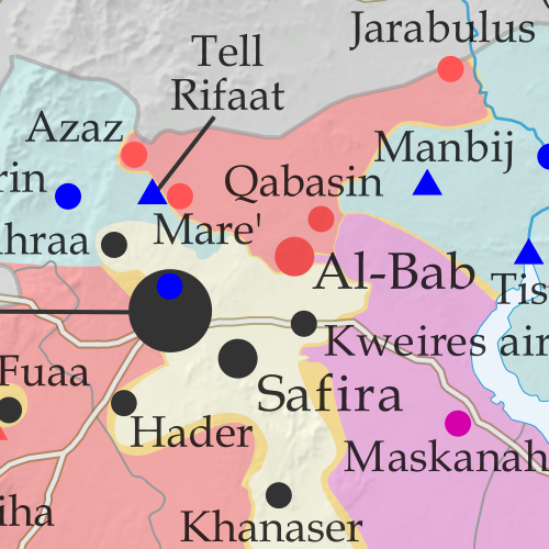
Map of fighting and territorial control in Syria's Civil War (Free Syrian Army rebels, Kurdish YPG, Syrian Democratic Forces (SDF), Jabhat Fateh al-Sham / Hayat Tahrir al-Sham (Al-Nusra Front), Islamic State (ISIS/ISIL), and others), updated to February 24, 2017. Now includes terrain and major roads (highways). Includes recent locations of conflict and territorial control changes, such as Al-Bab, Qabasin, Tasil, Abu Khashab, and more. Colorblind accessible In the past month, the so-called “Islamic State” (IS; formerly ISIS/ISIL) has lost control of Al-Bab, the third-largest city in Aleppo province, to Turkish-backed rebels, even as the Kurdish-led Syrian Democratic Forces (SDF) approach the group’s capital city of Raqqah in the east. And in southwestern Syria, rebels have lost ground to both government and IS forces.
 
See all this and more on the latest update to PolGeoNow’s concise, professional Syrian Civil War control map, which includes a timeline of changes since our previous Syria map report in January, with sources cited.

This map and report are premium professional content, available to paid subscribers of the PolGeoNow Conflict Mapping Service.

Want to see before you subscribe? Check out our most recent FREE SAMPLE Syria map!

Exclusive report includes:

  • Up-to-date map of current territorial control in Syria, color-coded for the Assad government, rebel groups, “Islamic State” (ISIS/ISIL) fighters, and Kurdish/SDF forces. Colorblind accessible.
  • Special symbols indicating towns dominated by rebels of the former Nusra Front (now Hayat Tahrir al-Sham) and Kurdish-led Syrian Democratic Forces (SDF).
  • Detailed indication of city-by-city control, including key towns and other locations important to current events.
  • Locations of recent fighting and other important events, including Al-Bab, Qabasin, Tasil, Abu Khashab, and more.
  • Detailed timeline of important events and changes to territorial control since January 20, 2017, compiled by our Syria-Iraq expert, with links to sources.

SUBSCRIBERS CLICK HERE TO PROCEED TO ARTICLE AND MAP

Not signed up yet? Click here to learn more about our professional subscription service!

Can I purchase just this map?
This map and report are not available for automated purchase to non-subscribers. If you need access or republication rights for only this map report, contact service@polgeonow.com for options.

Yemen Control Map & Report: February 2017 (Subscription)

SUBSCRIBERS CLICK HERE TO PROCEED TO ARTICLE AND MAP

There are newer versions of this map available. To see them, view all Yemen updates.

Map of what is happening in Yemen as of February 22, 2017, including territorial control for the Houthi rebels and former president Saleh's forces, president-in-exile Hadi and his allies in the Saudi-led coalition and Southern Movement, Al Qaeda in the Arabian Peninsula (AQAP), and the so-called Islamic State (ISIS/ISIL). Includes recent locations of fighting, including Mocha, Dhubab, Awhar, Lawdar, Shuqrah, and areas long the Yemen border with Saudi Arabia.

Subscribe for full access to all conflict map reports!

Timeline by Djordje Djukic. Map by Louis Martin-Vézian, Evan Centanni, and Djordje Djukic.

Since the beginning of 2017, forces loyal to the Yemen’s Saudi-backed President Hadi have gained ground against the Houthi government along the Red Sea coast, while fighters of Al Qaeda in the Arabian Peninsula (AQAP) have once again taken over parts of southern Yemen’s Abyan province.


See all this and more on the newest update to PolGeoNow’s Yemen territorial control map, which includes a timeline of changes and important events since our previous Yemen map report in late December.

This map and report are premium professional content, available to paid subscribers of the PolGeoNow Conflict Mapping Service.

Want to see before you buy? Check out our most recent FREE SAMPLE Yemen map report!

Exclusive report includes:

  • Up-to-date map of current territorial control in Yemen, color-coded for the pro-Hadi coalition, Houthi/Saleh forces, Al Qaeda in the Arabian Peninsula (AQAP), and the so-called “Islamic State” (ISIS/ISIL).
  • Detailed indication of town-by-town control, including provincial boundaries, all major cities, and many smaller ones
  • Markers for recent areas of fighting, including Mocha, Dhubab, Awhar, Lawdar, Shuqrah, and areas long the Yemen border with Saudi Arabia
  • Timeline of changes to the situation since December 30, 2016, with links to sources

SUBSCRIBERS CLICK HERE TO PROCEED TO ARTICLE AND MAP

Not a member yet? Click here to learn more about our professional subscription service!

Can I purchase just this map?
This map and report are not available for automated purchase to non-subscribers. If you need access or republication rights for only this map report, contact service@polgeonow.com for options.