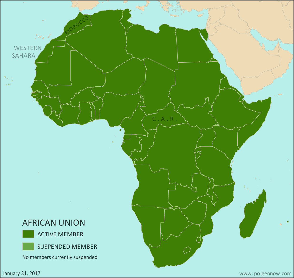
Morocco Joins African Union; CAR Un-suspended (Map)

African Union: Map of Africa showing which countries are in the African Union, including active and suspended member countries, updated for the January 2017 admission of Morocco as a member, as well as the April 2016 lifting of the Central African Republic's (CAR) suspension (colorblind accessible).
Map by Evan Centanni, from this blank map by Eric Gaba. License: CC BY-SA

(Subscribers click here to view this article in the members area.)

Article by Evan Centanni

Morocco Rejoins AU after Long Absence

The North African country of Morocco became the 55th member of the African Union (AU) this week, after member countries voted to let it back into the organization after 33 years on its own. Morocco withdrew from the Organisation for African Unity (OAU), an earlier version of the AU, in 1984. The AU now includes every independent country in Africa, not counting the unrecognized breakaway state of Somaliland. The last country to join was South Sudan, which became a member three weeks after declaring independence in July 2011.
Moroccan flagCountry Name:  
• Morocco (English)
• al-Maghrib (Arabic)
• Lmaɣrib (Berber)
Official Name:  
• Kingdom of Morocco (English)
• al-Mamlakah al-Maghribiyah (Arabic)
• Tageldit n Lmaɣrib (Berber)
Capital: Rabat

Why Morocco Withdrew from the African Union

Morocco’s hasty departure from the OAU three decades ago was a protest move, after the organization voted to let disputed Western Sahara become a member. Western Sahara is mostly controlled by Morocco, which absorbed it into the Moroccan kingdom after Spanish colonial forces withdrew in the 1970s.

But Morocco’s move was controversial, and the international community has never fully accepted it. Meanwhile, the local Polisario Front has considered Western Sahara an independent country since 1976 (formally known as the Sahrawi Arab Democratic Republic, or SADR).

Bringing Morocco Back Into the Fold

Reports suggest Morocco may hope that being part of the AU will help it end the SADR’s independence claims. Meanwhile the Polisario government, which represents Western Sahara in the AU, hopes for the opposite, arguing that membership in the organization will limit Morocco’s ability to play by its own rules.

A total of nine AU member countries, including South Africa, voted against Morocco’s readmission. Zimbabwe, Namibia, Mozambique, Botswana, and Algeria were also reportedly among the dissenters. Africans sometimes see Moroccan control of Western Sahara as a kind of continued colonialism, and several of the opposing countries are ones where freedom from European-imposed power systems didn’t come easily. A total of 39 countries voted in favor of letting Morocco back in, but with the understanding that Western Sahara would also remain a member.

(Editor’s note: The African Union has 54 members, not counting Morocco; our understanding is that six of them abstained from voting on the decision, or were absent.)
Flag of the Central African RepublicCountry Name:  
• Central African Republic (English)
• Centrafrique (French)
• Bêafrîka (Sango)
Official Name:  
• Central African Republic (English)
• République centrafricaine (French)
• Ködörösêse tî Bêafrîka (Sango)
Capital: Bangui

Central African Republic Suspension Lifted

Another change to the African Union map came in April 2016, when the Central African Republic (CAR) was reinstated as an active member of the organization after a three-year suspension. The CAR was suspended in 2013 after a rebel takeover of its capital, followed by the installation of a weak compromise government.

Though chaos and violence still continues in the country, the AU cited “the successful completion of the transition process and the restoration of normal constitutional order” when re-activating the country’s membership last year, referring to a new presidential election conducted in February. African Union rules don’t require countries to be democratic, but any unconstitutional change of government results in a quick suspension.

Haiti: The Country That DIDN’T Join the AU

In May of last year, news spread that the Caribbean island country of Haiti was about to join the African Union as a full member. Haiti has close cultural ties to Africa, since most of its population is descended from West Africans brought to the Caribbean as slaves. As the second country in the Americas to win independence, soon after the United States, it’s sometimes seen as a symbol of African liberation from colonialism.

By last year, the country already had an observer seat at the AU, but would have been the first member country without any territory on the African continent. Only one problem: Despite making its way into major, reputable news outlets, the story turned out to be untrue. Within days, the African Union issued a statement confirming that the reports were false, and that Haiti was not on track to ever become an AU member. The press release clarified that according to the organization’s founding rules, “only African States can join the African Union“. 

Graphics of the Moroccan flag and the Central African flag are in the public domain.
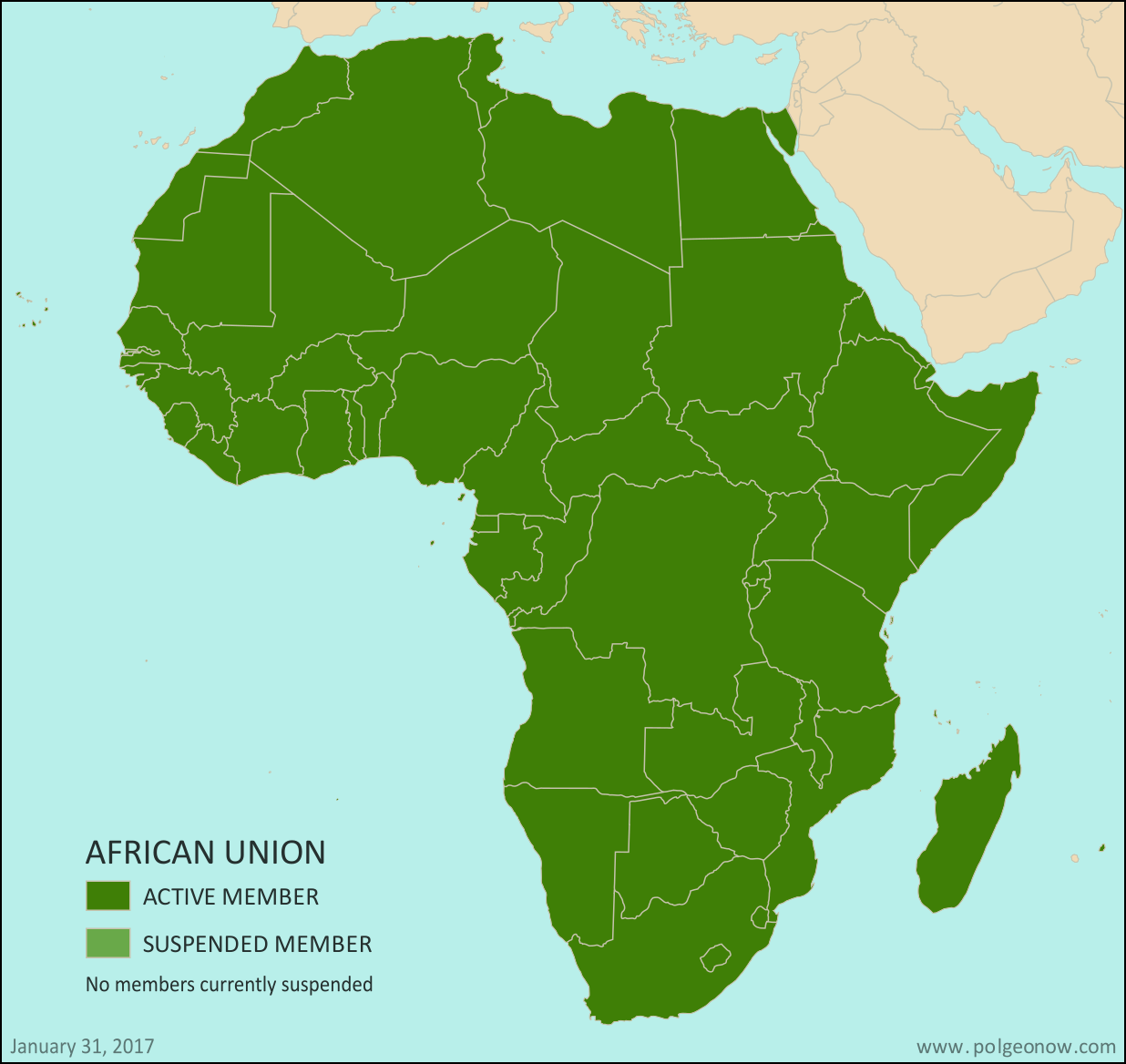
Map: Which Countries are in the African Union?

This map and explainer will be updated whenever there’s a change in AU membership, including suspensions and reinstatements. News about each change will be published in separate articles, which you can find listed below, or by viewing all African Union content on PolGeoNow.

African Union members map: Map of Africa, showing which countries are in the African Union (AU) (colorblind accessible).
Map by Evan Centanni, from this blank map by Eric Gaba. License: CC BY-SA

(Subscribers click here to view this article in the members area.)

Article by Evan Centanni

What is the African Union?

Formed launched in 2002 as a replacement for the earlier Organization of African Unity (OAU), the AU is an intergovernmental organization that works on increasing cooperation, stability, and development within the continent of Africa. The organization is headquartered in Addis Ababa, Ethiopia. (Ethiopia is the only African country that the European empires never colonized, and is also the second most populous country in Africa.)

Flag of the African Union (AU)Organization Name:  
• African Union (English)
• al-Āthḥād al-’Āfrīqī (Arabic)
• Union africaine (French)
• União Africana (Portuguese)
• Unión Africana (Spanish)
• Umoja wa Afrika (Swahili)
Launched: 2002 in Durban, South Africa
Headquarters: Addis Ababa, Ethiopia
Website: www.au.int

Compared to the neighboring European Union (EU), the AU is only a loose forum for cooperation between its member countries. AU members do not have an integrated economic system, union-wide laws, or shared foreign policy, though further integration is a goal for the future.

After the readmission of Morocco, the African Union now includes every UN-recognized country in Africa. The parts of Africa not represented in the AU are a few groups of offshore islands controlled by European countries, as well the small Spanish enclaves in North Africa. The breakaway Republic of Somaliland is not a member, but is considered by the AU to be part of member-state Somalia.

Changes to African Union Membership

Political Geography Now has reported on all changes to the African Union members map, including suspensions and reinstatements, since 2013. The news articles for each of these changes, with maps pointing out the countries involved, are listed here:

Map of Africa showing active and suspended members of the African Union (AU). Updated for the January 2017 admission of Morocco and the April 2016 lifting of the Central African Republic's suspension (colorblind accessible).Morocco Joins African Union; CAR Un-suspended (Map)
The North African kingdom of Morocco joined the AU in January 2017, 33 years after withdrawing from an earlier version of the organization. The Central African Republic’s suspension was lifted in April 2016.

Full map and article

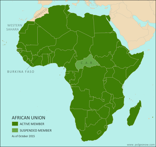
Map of Africa showing active and suspended members of the African Union (AU). Updated for the September 2015 suspension and reinstatement of Burkina Faso (colorblind accessible).African Union Suspends Burkina Faso, Then Reinstates it Again
In September 2015, the West African country of Burkina Faso was suspended from the AU after a military coup, but quickly reinstated to active membership when the coup leaders backed down.

Full map and article

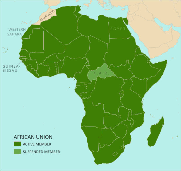
Map of Africa showing active and suspended members of the African Union (AU). Updated for the June 2014 reinstatement of suspended members Egypt and Guinea Bissau (colorblind accessible).African Union Reinstates Egypt and Guinea Bissau
North Africa’s Egypt and West Africa’s Guinea Bissau both had their AU suspensions lifted in June 2014, after each held new elections to replace a coup-installed government.

Full map and article

Map of Africa showing active and suspended members of the African Union (AU). Updated for the January 2014 reinstatement of suspended member Madagascar (colorblind accessible).Madagascar Un-suspended from African Union 
The African island country of Madagascar ended its five-year suspension from the AU in January 2014, after a coup-installed military government was replaced with a newly elected president.

Full map and article

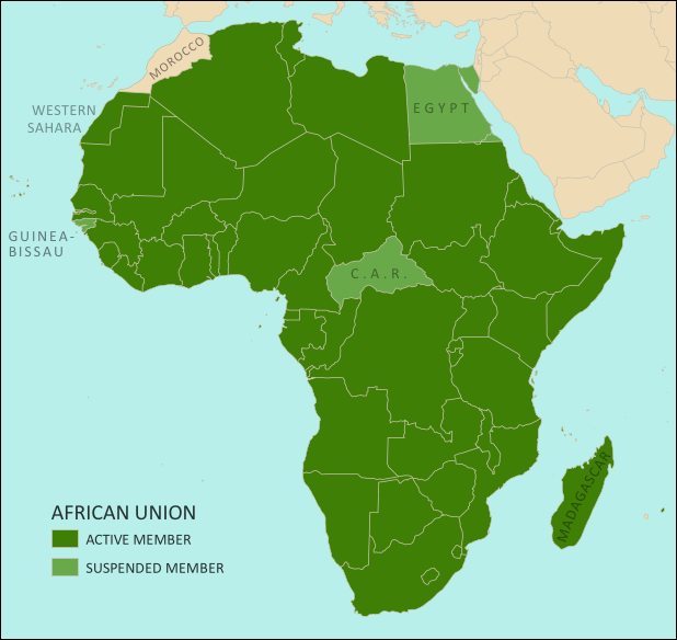
Map of Africa showing active and suspended members of the African Union (AU). Updated for the July 2013 suspension of Egypt (colorblind accessible).Egypt Suspended from African Union 
The North African country of Egypt, one of Africa’s largest, was suspended from the AU in July 2013 after a military coup.

Full map and article

Low-resolution graphic of the African Union flag is displayed under fair use principles (source).

Syria Control Map & Timeline: January 2017 (Subscription)

SUBSCRIBERS CLICK HERE TO PROCEED TO ARTICLE AND MAP

There are newer versions of this map available. To see them, view all Syria updates.

Research by Djordje Djukic. Map by onestopmap.com, Evan Centanni, and Djordje Djukic

Subscribe for full access to all conflict map reports!


Map of fighting and territorial control in Syria's Civil War (Free Syrian Army rebels, Kurdish YPG, Syrian Democratic Forces (SDF), Jabhat Fateh al-Sham (Al-Nusra Front), Islamic State (ISIS/ISIL), and others), updated to January 20, 2017. Now includes terrain and major roads (highways). Includes recent locations of conflict and territorial control changes, such as the Barada Valley, Hazrama, Thawra, the T4 airbase, and more. Colorblind accessible. In the past month, Syria’s Assad government has continued to consolidate its power after a major victory over the rebels in the city of Aleppo. Meanwhile, forces of the so-called “Islamic State” (ISIS/ISIL) have lost ground to Kurdish-led militias even while holding their own against the Syrian Army.
 
See all this and more on the latest update to PolGeoNow’s concise, professional Syrian Civil War control map, which includes a timeline of changes since our previous Syria map report in December, with sources cited.

This map and report are premium professional content, available to paid subscribers of the PolGeoNow Conflict Mapping Service.

Want to see before you subscribe? Check out our most recent FREE SAMPLE Syria map!

Exclusive report includes:

  • Up-to-date map of current territorial control in Syria, color-coded for the Assad government, rebel groups, “Islamic State” (ISIS/ISIL) fighters, and Kurdish/SDF forces. Colorblind accessible.
  • Special symbols indicating towns dominated by rebels of the former Nusra Front (now Jabhat Fateh al-Sham) and US-backed Syrian Democratic Forces (SDF).
  • Detailed indication of city-by-city control, including key towns and other locations important to current events.
  • Locations of recent fighting and other important events, including the Barada Valley, Hazrama, Thawra, the T4 airbase, and more.
  • Detailed timeline of important events and changes to territorial control since December 18, 2016, compiled by our Syria-Iraq expert, with links to sources.

SUBSCRIBERS CLICK HERE TO PROCEED TO ARTICLE AND MAP

Not signed up yet? Click here to learn more about our professional subscription service!

Can I purchase just this map?
This map and report are not available for automated purchase to non-subscribers. If you need access or republication rights for only this map report, contact service@polgeonow.com for options.

Iraq Control Map & Timeline: The Battle for Mosul – January 2017 (Subscription)

SUBSCRIBERS CLICK HERE TO PROCEED TO ARTICLE AND MAP

There are newer versions of this map available. To see them, view all Iraq updates.

Research by Djordje Djukic. Map by onestopmap.com, Evan Centanni, and Djordje Djukic

Subscribe for full access to all conflict map reports!


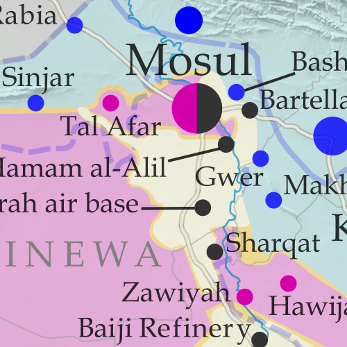
Detailed map of territorial control in Iraq as of January 10, 2016, including territory held by the so-called Islamic State (ISIS, ISIL), the Baghdad government, and the Kurdistan Peshmerga. Shows developments in the ongoing coalition battle to recapture the city of Mosul. Includes key locations from recent events, such as Mosul, Al-Sagra, and Hamam al-Alil. Colorblind accessible. Over the past two months, a battle has raged for control of Mosul, the second-largest city in Iraq and the largest controlled by the so-called “Islamic State” (ISIS/ISIL). Government and allied forces have made slow but steady progress in the city and nearby areas, even while advancing in western Iraq’s Anbar province at the same time.
 
See all this and more on the latest update to PolGeoNow’s concise, professional map of control in Iraq’s civil war, including a timeline of changes since our previous Iraq map report of November 2016.

This map and report are premium professional content, available to paid subscribers of the PolGeoNow Conflict Mapping Service.

Want to see before you subscribe? Check out our most recent FREE SAMPLE Iraq map report!

Exclusive report includes:

  • Up-to-date map of current territorial control in Iraq, color-coded for the Iraqi government, “Islamic State” (ISIS/ISIL) extremists, and Kurdistan’s Peshmerga forces. Colorblind accessible.
  • Detailed indication of town-by-town control, including provincial boundaries, all major cities, and many smaller ones
  • Markers for key areas of recent fighting such as Mosul, Tal Afar, Al-Sagra, and Hamam al-Alil
  • Timeline of changes to the situation since early November, compiled by our Iraq specialist, with links to sources

SUBSCRIBERS CLICK HERE TO PROCEED TO ARTICLE AND MAP

Not signed up yet? Click here to learn more about our professional subscription service!

Can I purchase just this map?
This map and report are not available for automated purchase to non-subscribers. If you need access or republication rights for only this map report, contact service@polgeonow.com for options.

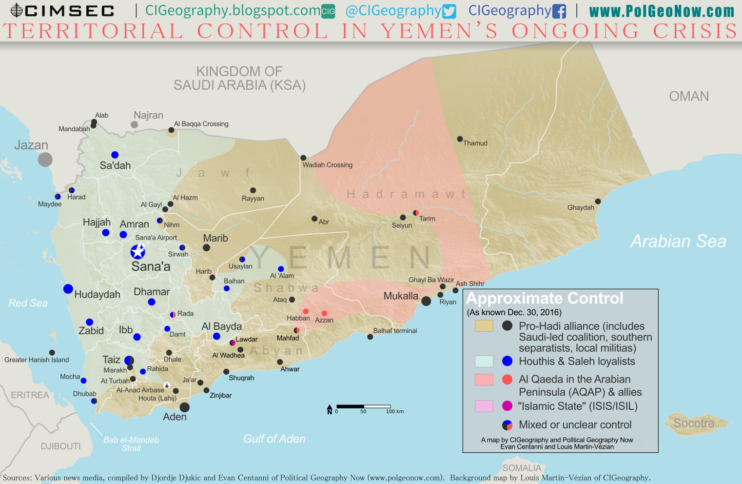
Yemen Control Map & Report: December 2016

There are newer versions of this map available. To see them, view all Yemen updates.

This is part of a series of Yemen maps and infographics created in collaboration between PolGeoNow and CIGeography.

Map of what is happening in Yemen as of December 30, 2016, including territorial control for the Houthi rebels and former president Saleh's forces, president-in-exile Hadi and his allies in the Saudi-led coalition and Southern Movement, Al Qaeda in the Arabian Peninsula (AQAP), and the so-called Islamic State (ISIS/ISIL). Includes recent locations of fighting, including Al Gail, Sirwah, Usaylan, and areas long the Yemen border with Saudi Arabia.
Click to enlarge. Map by Louis Martin-Vézian, Evan Centanni, and Djordje Djukic. All rights reserved.

(Subscribers click here to view this article in the members area.)

Timeline by Djordje Djukic

Situation Summary
In the past three months since our previous Yemen control map report, fighting has continued between Houthi rebels and forces loyal to the Saudi-backed government of President Hadi, with small changes to territorial control on the eastern and northern fringes of Houthi territory, including along Yemen’s border with Saudi Arabia. Meanwhile, Al Qaeda in the Arabian Peninsula (AQAP) has remained entrenched in parts of the east, while allegedly capturing an area near its one-time stronghold of Rada in the country’s west.

Flag of YemenCountry Name:  
• Yemen (English)
• Al-Yaman (Arabic)
Official Name:  
• Republic of Yemen (English)
al-Jumhūriyyah al-Yamaniyyah (Arabic) 
Capital: Sana’a (official); Aden (seat of internationally-recognized government)

Chronology of Events
The following is a timeline of major events and changes to territorial control since PolGeoNow’s previous Yemen control map report of September 23, 2016.

October 1, 2016
Pro-Hadi forces captured the the village of Al Gayl, which they claimed to be the last Houthi stronghold in Jawf province. Meanwhile, the Houthis claimed they hit a UAE military ship in the Bab al-Mandeb Strait, while according to the UAE the vessel that was hit was an aid ship en route to Aden.

October 8, 2016
At least 140 people were killed and more than 500 wounded in several airstrikes on a funeral reception in Sana’a which was attended by military and intelligence officials of the Houthi-led government.

October 9, 2016
The US Navy guided missile destroyer Mason was targeted in a failed missile attack from Houthi-held territory in Yemen.

October 12, 2016
The USS Mason was targeted in a second failed missile attack off the coast of Yemen.

October 13, 2016
In retaliation for the two missile attacks, the USS Mason targeted and destroyed three coastal radar sites in Houthi-held areas, using cruise missiles.

November 2, 2016
Twenty-eight Houthi and six pro-Hadi fighters were reportedly killed in fighting in Taiz.

November 7, 2016
The WHO announced that at least 7,070 people had been killed and 36,818 injured in the conflict in Yemen since the start of the Saudi-led intervention in March 2015.

November 15-16, 2016
Fighting in Maydee and Harad on the border between Yemen and Saudi Arabia, as well as in Taiz, left 46 pro-Houthi and 39 pro-Hadi fighters dead, in addition to five civilians. During the clashes in Taiz, pro-Hadi forces managed to advance towards the Houthi-held presidential residence and police headquarters.

November 17-18, 2016
Twenty-four Houthi and 14 pro-Hadi fighters were reportedly killed in Taiz, as well as two civilians, dashing any hopes of a ceasefire that had been announced by US Secretary of State John Kerry, which was supposed to start on November 17. Instead, a 48-hour ceasefire began on November 19.

November 21-22, 2016
Following the fragile two-day ceasefire, heavy fighting in Taiz and Maydee left a reported 29 Houthi and 12 pro-Hadi fighters dead.

November 24, 2016
More fighting in Taiz killed 10 Houthi fighters.

November 28, 2016
The Houthis and their political allies formed a new government. A Hadi spokesman deemed the move “a disregard not just for the Yemeni people, but also for the international community”.

December 2, 2016
The Saudi-led coalition claimed that 172 people were killed and 686 wounded due to indiscriminate shelling in Taiz by pro-Houthi forces during the month of November.

December 4-5, 2016
Pro-Hadi troops captured the Alab border crossing, which is one of two border crossings between Saudi Arabia and Yemen’s Sa’dah province. The second crossing, Al Baqqa, had already been taken by pro-Hadi troops previously. The fighting spread the following day to the nearby Mandabah mountain. Pro-Hadi forces also claimed that the Houthis had withdrawn from the port town of Maydee. However, fighting was still being reported around the town 15 days later.

December 10, 2016
An IS suicide bomber killed between 48 and 50 soldiers and wounded around 70 at a base in Aden.

December 12-15, 2016
Al-Qaeda captured a mountain in Bayda province and claimed to have also seized an area of the Rada district from pro-Houthi forces.

December 13, 2016
Eighteen Houthi fighters were reportedly killed in fighting in Taiz, while Houthi forces attempted to recapture a hill overlooking the Sirwah airport in Marib province, which they had recently lost.

December 18, 2016
An IS suicide bomber killed between 49 and 52 soldiers and wounded between 34 and 60 in Aden while they were collecting their salaries.

December 18-19, 2016
Houthi fighters managed to temporarily capture a hilly air-defense base on the western edge of Taiz, before they were forced to retreat the following morning. Pro-Hadi forces claimed 41 Houthi fighters were killed, while they lost nine. Meanwhile, pro-Hadi forces reportedly captured Mandabah mountain on the Yemeni-Saudi border.

December 22, 2016
Seven Pakistani crew members of an Iranian cargo ship were killed when their ship was sunk in a rocket attack off the coast of Yemen.

December 23, 2016
Saudi artillery and helicopter strikes on the Saudi-Yemeni border reportedly killed at least 30 pro-Houthi fighters, while the US military reported 28 Al Qaeda militants were killed in nine strikes between September 23 and December 13 in Yemen.

December 24, 2016
Pro-Hadi forces captured several areas in the Nihm district northeast of Sana’a.

December 27, 2016
Twenty-eight Houthi and 12 pro-Hadi fighters were reportedly killed in fighting in the southern province of Shabwa when pro-Hadi forces launched an offensive against Baihan. Fighting also took place at nearby Usaylan. Pro-Hadi forces claimed to have made advances during the offensive.

December 29, 2016
Pro-Hadi troops reportedly captured three regions of the Usaylan district in Shabwa province and were trying to push towards Baihan. At least 10 Houthi fighters were killed in the fighting.

CHECK FOR UPDATES: View all Yemen maps on PolGeoNow

Graphic of Yemeni flag is in the public domain (source).

What is Wallonia? Belgium’s Unusual Federal System

(Subscribers click here to view this article in the members area.)

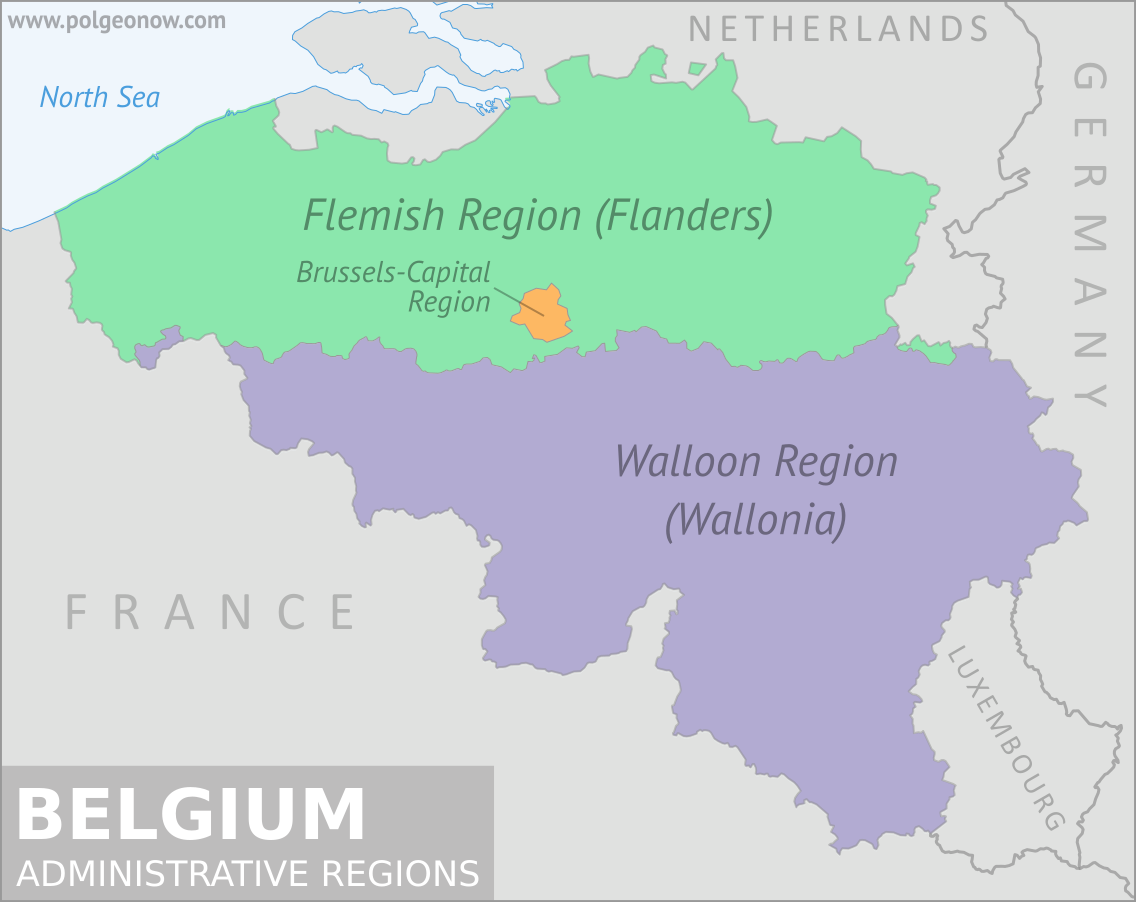
Map of Belgium's three official administrative regions: the Flemish Region (Flanders), the Walloon Region (Wallonia), and the Brussels-Capital Region
Map of Belgium's three official Language Communities: the Flemish Community, the Walloon Community, and the German-speaking Community
Maps by Evan Centanni, from base map by Vascer
(CC BY-SA)

By Bryn Jansson
 

Wallonia vs. the European Union

Belgium often seems like an afterthought in European politics. It doesn’t have the economic clout of a Germany, the political influence of a France, or the military power of a Britain. It’s a small country tucked into the northwest corner of Europe, and known mostly for its chocolate and beer (though the acclaim both have earned is well-deserved). It’s home to the European Union headquarters in Brussels, but otherwise holds no special political power in the for-now 28-nation bloc.

Yet there it was this October, caught in the middle of a European political drama, the lone holdout of the EU-28 against the Comprehensive Economic and Trade Agreement (CETA), a large scale free-trade deal with Canada. Even more amazingly, it wasn’t even the whole of Belgium blocking the trade deal, but only the sub-region of Wallonia, home to 32 percent of Belgians (known as “Walloons”) and less than 1 percent of EU citizens.

So how did a region accounting for only about 10 percent of Belgian exports to Canada find itself with the power to thwart the EU and its own national government on CETA? In a nutshell, the answer lies in an unusually complex domestic political scene that has, over the past 45 years, devolved so much power to sub-national governments that the federal government must get approval from each of the constituent parts before making a trade agreement, as well as some other types of international deals. How Belgium got here is, as you might expect, a long story.

Flag of Belgium Country Short Name:  
• Belgium (English) 
• België (Dutch/Flemish)
• Belgique (French)
• Belgien (German)
Full Official Name:  
• Kingdom of Belgium (English)
• Koninkrijk België (Dutch/Flemish)
• Royaume de Belgique (French)
• Königreich Belgien (German) 
Capital: Brussels

How Belgium Works

Most modern federal countries are made up of non-overlapping sub-national territories: think American states, German Länder or even Australian states and territories. But Belgium, in its own special way, set up its federation to include two overlapping but closely related sets of territories. There are the three “regions” – the Flemish Region (a.k.a. “Flanders”) in the north, the Walloon Region (Wallonia) in the south, and the capital territory of Brussels, an enclave surrounded by southern Flanders – which are the closest thing to the traditional states or provinces we’re used to. These regions have power over things like the economy, transportation, and territorial planning.

Laid over that map, there are three language-based “Communities”: the Flemish Community, the French Community, and the German-speaking Community. The Flemish Community (Flemish being the Belgian variety of Dutch) includes all of Flanders, and the French Community includes most of Wallonia, with Brussels shared between the two. Meanwhile, the German-speaking Community lies within Wallonia, along Belgium’s eastern border with Germany. The Communities have control over things like culture, education, and language matters. Both the Flemish and French Communities share influence over Community-level issues in bilingual Brussels.

Flag of the Walloon Region (Wallonia) Territory Name 
• Wallonia (English) 
• Wallonie (French)
Wallonie/Wallonien (German)
Full Official Name:  
• Walloon Region (English)
• Région wallonne (French)
• Wallonische Region (German) 
Capital: Namur
Status: Federal Region of Belgium

Each of the regions and communities has its own Council (Parliament) and government (executive branch), though the Flemish Region and language community long ago merged their councils and parliaments, leaving five federal entities in total. The Belgian system requires all five governments to approve any trade deal before the federal government can give its assent. In CETA’s case, Flanders, the German-speaking Community, and the federal government were all in favor, but the Walloon region and the French Community (remember, largely the same territory), plus Brussels, hesitated. With no coercive powers, all Belgium and the EU could do was negotiate with the holdouts.

Now, who would ever purposely choose to design a system this convoluted? If you answered “Belgians,” you’d be right, but even they didn’t go straight there. Belgium’s system came about through a long and complex, but fascinating, history.

How Did Belgium Get This Way?

Modern Belgium became a country in 1830, when the largely Catholic southern half of the United Kingdom of the Netherlands broke away from the politically dominant Protestant-majority northern half, creating the Kingdom of Belgium. While religiosity is now down in Belgium (as it is all over Europe), the Catholic Church is still largely seen as a unifying force there.

Although Belgium is a country united, at least historically, by religion, it’s also strongly divided by language. As described above, it has three official languages (Dutch/Flemish, French, and German), though French has long been politically dominant. This language divide has historically been a sore spot for many Flemings, as political power was controlled by French-speaking elites, and for much of Belgium’s early history, French was the only language of official business. For a time it was illegal for courts and schools to use Flemish, while even the Flemish upper classes generally spoke French and looked down on Flemish-speakers. Even today, after years of officially bilingual policy, most Walloons speak no Dutch, while most Flemings speak at least some French.*

Is it “Wallonian” or “Walloon”?

It’s standard to use the word Walloon when referring to someone or something from Wallonia. Although Wallonian sounds like a normal way to construct a word in English, it’s only used as a rare variant.

Wallonian is missing from most dictionaries, and Google search results are dominated by a type of brewer’s yeast sold in California.

A search of usage in Google’s book database shows that Walloon is vastly more common, though published instances of Wallonian did increase sharply in the second half of the 20th Century.

The economy has always been unbalanced in Belgium, too. Wallonia was the first region in continental Europe to industrialize in the early 19th century, and it continued to be a powerhouse of heavy industry until the end of the post-World War II economic boom in Western Europe. As the aged industrial infrastructure surviving the war deteriorated, coal mines began to dry up, and previously wealthy Wallonia slipped into economic decline.*

Meanwhile, as Wallonia was first taking off industrially, Flanders remained more agricultural. With the best coal mines and steel plants farther south, Flanders stayed significantly poorer than its French-speaking neighbor until a boom hit in the 1960s. Largely because it wasn’t tied to a dying heavy industry sector, Flanders was able to more easily develop a vibrant light industry and service economy.*

As a result, Flanders was no longer the economic laggard, and began demanding the political power to accommodate the shift. Beginning in 1970, a series of constitutional reforms began the process of decentralizing political power. The first move, in 1970, was the creation of the language communities, followed by the regions in 1980. Further powers were devolved over the course of the 1980s, and in 1993 the Belgian constitution was amended to fully reflect the federal structure. Tweaks in 2001 – including the devolution of economic (and thus trade) policy to the regions – and 2012 have sorted out further conflicts. Ironically, it was the Flemings who pushed for devolution of trade powers – a move that later allowed Wallonia to block the Flanders-supported trade deal.

Belgium “didn’t have a government” in 2010-2011?!

When people say Belgium went 20 months “without a government”, they don’t mean it was in a state of anarchy. Unlike Americans, Europeans use the word “government” for just the Prime Minister and cabinet (the country’s administrative structure is called “the state”).

During Belgium’s government crisis, there was an elected legislature, functioning courts, and full police presence. The previous cabinet even stayed on as a substitute to make the most crucial and uncontroversial government decisions. And, unlike in the US “government shutdown”, national services and administrative bureaucracy continued uninterrupted.

This series of constitutional reforms reflected a struggle to keep Wallonia from having too much control over Flanders or vice versa. But the strengthening of the regional governments has taken a toll on national politics. Belgium takes an average of 98 days to form a parliamentary government after an election, the longest of any democracy in Europe. It also holds the world record for longest period without an elected government in a democracy – a whopping 541 days in 2010-2011.

It’s this weak federal government role that gave little Wallonia the power to block the massive trade deal with Canada, after the EU decided to pursue an ambitious type of arrangement that required the approval of all 28 member countries. Most EU countries have kept that power contained at the national level, where there’s a greater consensus for free trade. But the decentralized Belgian system gave Wallonia a voice that allowed it to rise above the Belgian reputation for beer, chocolate, and Brussels – at least until a few tweaks to the treaty satisfied the Walloon government, and it allowed the EU and Canada to finally sign CETA on October 30.

*Source: Judt, Tony. Postwar: A History of Europe Since 1945

Graphics of the Belgian flag and the Walloon flag are in the public domain.
Syria Control Map & Timeline: Assad Retakes Aleppo – December 2016 (Subscription)

SUBSCRIBERS CLICK HERE TO PROCEED TO ARTICLE AND MAP

There are newer versions of this map available. To see them, view all Syria updates.

Research by Djordje Djukic. Map by onestopmap.com, Evan Centanni, and Djordje Djukic

Subscribe for full access to all conflict map reports!


Map of fighting and territorial control in Syria's Civil War (Free Syrian Army rebels, Kurdish YPG, Syrian Democratic Forces (SDF), Jabhat Fateh al-Sham (Al-Nusra Front), Islamic State (ISIS/ISIL), and others), updated to December 18, 2016. Now includes terrain and major roads (highways). Includes recent locations of conflict and territorial control changes, such as Aleppo, Palmyra, Khan al-Shih, Mayda'ani, and more. Colorblind accessible. There have been big and important changes to territorial control in Syria in the past month. The Assad government has retaken most of Syria’s second biggest city, as well as several other areas of the country, even as the so-called “Islamic State” (ISIS/ISIL) has recaptured the historic desert town of Palmyra.
 
See all this and more on the latest update to PolGeoNow’s concise, professional Syrian Civil War control map, which includes a timeline of changes since our previous Syria map report in November, with sources cited.

This map and report are premium professional content, available to paid subscribers of the PolGeoNow Conflict Mapping Service.

Want to see before you subscribe? Check out our most recent FREE SAMPLE Syria map!

Exclusive report includes:

  • Up-to-date map of current territorial control in Syria, color-coded for the Assad government, rebel groups, “Islamic State” (ISIS/ISIL) fighters, and Kurdish/SDF forces. Colorblind accessible.
  • Special symbols indicating towns dominated by rebels of the former Nusra Front (now Jabhat Fateh al-Sham) and US-backed Syrian Democratic Forces (SDF).
  • Detailed indication of city-by-city control, including key towns and other locations important to current events.
  • Locations of recent fighting and other important events, including Aleppo, Palmyra, Khan al-Shih, Mayda’ani, and more.
  • Detailed timeline of important events and changes to territorial control since November 23, 2016, compiled by our Syria-Iraq expert, with links to sources.

SUBSCRIBERS CLICK HERE TO PROCEED TO ARTICLE AND MAP

Not signed up yet? Click here to learn more about our professional subscription service!

Can I purchase just this map?
This map and report are not available for automated purchase to non-subscribers. If you need access or republication rights for only this map report, contact service@polgeonow.com for options.

Libya’s “Islamic State” Loses Last City: Dec. 2016 Control Map & Timeline (Subscription)

SUBSCRIBERS CLICK HERE TO PROCEED TO ARTICLE AND MAP

There are newer versions of this map available. To see them, view all Libya updates.

Research by Djordje Djukic, with Evan Centanni. Map by onestopmap.com and Evan Centanni.

Subscribe for full access to all conflict map reports!

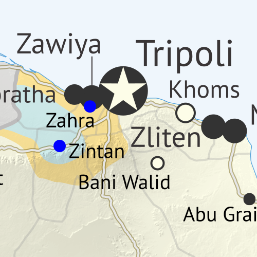
Libya control map: Shows detailed territorial control in Libya's civil war as of December 2016, including all major parties (Government of National Accord (GNA); Tobruk House of Representatives, General Haftar's Libyan National Army, Zintan militias, Petroleum Facilities Guard (PFG); Tripoli GNC government, Libya Dawn, and Libya Shield Force; Shura Council of Benghazi Revolutionaries and other hardline Islamist groups; and National Salvation Government). Also file under: Map of Islamic State (ISIS or ISIL) control in Libya. Now includes terrain and major roads. Colorblind accessible. In the past three months, a lot has changed in Libya, including the expulsion of the so-called “Islamic State” (ISIS/ISIL) from its last territory in North Africa. Meanwhile, Libya now has three competing governments, and key oil ports have changed hands.
 
See all this and more on the latest update to PolGeoNow’s concise, professional Libyan Civil War control map, which comes with a timeline of changes since our September 2016 Libya map report.

This map and report are premium content available to paid subscribers of the PolGeoNow Conflict Mapping Service.

Want to see before you subscribe? Check out our most recent FREE SAMPLE Libya map!

Exclusive report includes:

  • Up-to-date map of current territorial control in Libya, color-coded for the UN-backed Government of National Accord (GNA), the rival Tobruk parliament (supported by General Haftar’s Libyan National Army), religious hardline groups, and other actors such as the revived “National Salvation Government” and unaligned local councils.
  • Detailed indication of city-by-city control, including key towns and other locations important to current events.
  • Locations of recent fighting and military operations, including Sirte, Sidra, Ras Lanuf, Brega, and more.
  • Detailed timeline of important events and changes to territorial control since September 6, 2016, with all sources cited.
  • New since last year: Major roads are marked on the map for reference

SUBSCRIBERS CLICK HERE TO PROCEED TO ARTICLE AND MAP

Not signed up yet? Click here to learn more about our professional subscription service!

Can I purchase just this map?
This map and report are not available for automated purchase to non-subscribers. If you need access or republication rights for only this map report, contact service@polgeonow.com for options.

Syrian Civil War Control Map & Report: November 2016

There are newer versions of this map available. To see them, view all Syria updates.

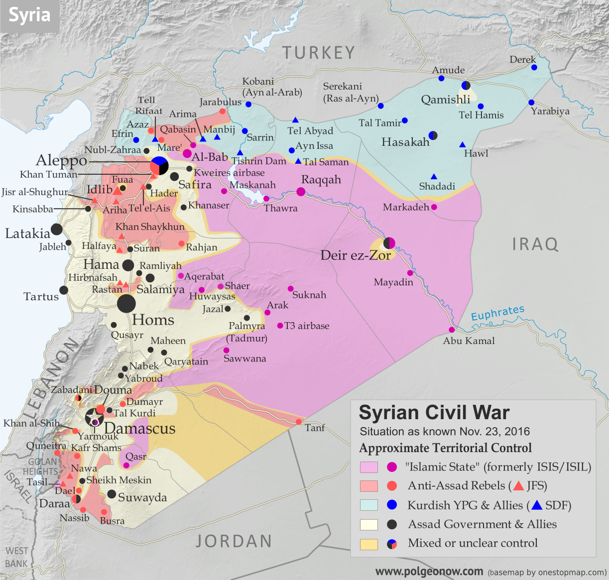
Map of fighting and territorial control in Syria's Civil War (Free Syrian Army rebels, Kurdish YPG, Syrian Democratic Forces (SDF), Jabhat Fateh al-Sham (Al-Nusra Front), Islamic State (ISIS/ISIL), and others), updated to November 23, 2016. Now includes terrain and major roads (highways). Includes recent locations of conflict and territorial control changes, such as Al-Bab, Khan al-Shih, Tal Saman, Qabasin, and more. Colorblind accessible.
Base map by Koen Adams of onestopmap.com, with territorial control by Evan Centanni and Djordje Djukic.
All rights reserved.

(Subscribers click here to view this article in the member area.)

Timeline by Djordje Djukic, with additional reporting by Evan Centanni

Situation Summary
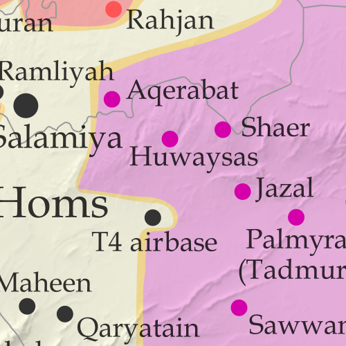
In the past month since our previous Syrian Civil War map update, fighting has focused largely on the ongoing battle for the city of Aleppo, where rebels control a large enclave in the east, as well as a three-way fight for control of Al-Bab, the largest town in the countryside east of Aleppo (at least, according to pre-war census figures). Held for nearly three years by the so-called “Islamic State” (IS; formerly ISIS/ISIL), Al-Bab is now the target of both the Turkish-backed Free Syrian Army (FSA) rebels and the US-backed Syrian Democratic Forces (SDF) coalition led by Kurdish militias. The SDF has also made progress toward the IS capital of Raqqah in the east, while the Syrian Army of President Bashar al-Assad is making slow progress against rebels in the west of the country.

Flag of Syria under the current governmentCountry Name:  
• Syria (English)
• Sūriyya/Sūryā (Arabic)
Official Name:  
• Syrian Arab Republic (English)
• al-Jumhūriyyah al-‘Arabīyah  as-Sūriyyah (Arabic)
Capital: Damascus

Note: Red triangles on the map represent towns where rebel group Jabhat Fateh al-Sham (JFS), formerly known as Al Qaeda affiliate Jabhat al-Nusra (a.k.a. the Nusra Front), is thought to be in a dominant position among rebel forces, even if it doesn’t exercise exclusive control. This organization has some presence in almost every rebel-held area in Syria.

Timeline of Events
The following is a timeline of changes to territorial control and other key events in Syria since our previous map update of October 23, 2016. Sources are provided in the form of links.

October 26-27, 2016
The race for control of IS-held Al-Bab continued as Turkish-backed Free Syrian Army (FSA) rebels seized three villages from the group north of the town, while the Kurdish-led SDF captured four villages from the rebels (two west and two east of Al-Bab). With the advances, the rebels were 13 kilometers from Al-Bab, while the SDF was positioned at a distance of18 kilometers..

October 27, 2016
The Syrian Army recaptured the town of Suran, north of Hama, which it had lost to rebels at the end of August. Meanwhile, northeast of Aleppo, the race to the IS-held town of Al-Bab continued. The Kurdish-led SDF captured several villages from the Turkish-backed rebels, while the rebels themselves took control of several villages from IS.

October 28, 2016
The SDF and the Syrian Army jointly seized half a dozen villages from IS, northeast of Aleppo, and a former Infantry College came under the control of the army. Elsewhere, the army surrounded the rebel-held town of Khan al-Shih, southwest of Damascus.

October 28-November 12, 2016
Rebels launched an offensive on the government-held western part of Aleppo city in an attempt to break the siege of the rebel-held eastern section. In the first two days of the operation, they managed to capture the Minyan Sawmills, most of the Dahiyat al-Assad district and half of the Minyan district. During this period, 12 suicide bombers were used against government positions.

On November 3, the rebels launched the second phase of their offensive, attacking the New Aleppo district, but the assault was ultimately repelled. At this point, the rebel offensive slowed and on November 6, government forces launched a counter-attack in the southwest of the city. By November 12, pro-government troops had managed to reverse all rebel gains and additionally retake territory they had lost in the rebels’ summer offensive.

Between October 28 and November 11, 291 rebels and 146 pro-government fighters were killed in the offensive, along with 96127 civilians who died due to rebel shelling. An additional 350-400 rebels and 200-300 pro-government fighters were wounded. Pro-rebel media also reported nearly 500 civilian deaths from government shelling in eastern Aleppo.

October 30, 2016
The army captured Tal Kurdi, as well as one other nearby town, east of Damascus, further shrinking the rebel pocket known as Eastern Ghouta and coming closer to the rebel stronghold of Douma.

November 1-2, 2016
IS managed to recapture 17 villages from the Turkish-backed rebels northeast of Aleppo.

November 4, 2016
The army captured a village near the town of Khan al-Shih. Thirty-three rebels were reported killed in the area the previous day.

November 5, 2016
A rebel assault north of Hama resulted in the capture of several positions. However, an army counter-attack subsequently regained all lost territory.

November 6-15, 2016
The Turkish-backed rebels captured 36 villages from IS north of Al-Bab, advancing to within two kilometers of the town. On November 14, the rebels managed to enter the northern outskirts of Al-Bab, but were forced to withdraw one kilometer to the north of the town the next day. Concurrently, between November 11 and 15, the SDF captured 15 villages east of Al-Bab from IS, besieging the town of Arima.

November 6-22, 2016
On November 6, the SDF announced the start of the offensive to reach the IS capital of Raqqah. Within 15 days, they managed to seize 48 villages and farms from IS, including the strategic hilltop village of Tal Saman, 26 kilometers north of Raqqah. Following these advances, the SDF said Phase One of their offensive (cutting of Raqqah from its northern countryside) had been completed. The aim of Phase Two was to enforce a full blockade of the city. By November 22, the SDF was 20 kilometers north of Raqqah. At this point, the SDF threatened to halt the offensive if the US-led coalition did not force Turkey to halt attacks on SDF forces in the Manbij area.

The previous day, Turkish-backed rebels attacked and temporarily captured a village northeast of Al-Bab from the SDF, before the Kurdish-led forces managed to retake it.

November 8-13, 2016
The Syrian Army took control of a strategic road southwest of Damascus, tightening the siege of Khan al-Shih. Over the next five days, the town was hit with more than 140 barrel bombs and ground-to-ground missiles.

November 12, 2016
Government forces captured two villages south of Aleppo.

November 15-23, 2016
A new Syrian-Russian offensive on the rebel-held eastern part of Aleppo city was announced with heavy Russian airstrikes. By November 22, the military managed to seize a strategic hill overlooking the rebel-held Hanano district, half of Hanano itself, and 75 percent of the central Bustan al-Basha district. Reports said 159 civilians had been killed in the first seven days of the offensive. Of these, 143 died due to pro-government shelling and airstrikes, while 16 were killed by rebel shelling.

November 15-23, 2016
On November 15, rebels attacked the IS-held town of Qabasin, northeast of Al-Bab, and over the next eight days the town changed hands six times, ending up under IS control at press time.

November 17-19, 2016
The army managed to seize two areas west and east of Khan al-Shih before a surrender agreement was reached for the town’s rebel administration. Under the agreement, after a two-day ceasefire, 1,000 rebels would be evacuated to Idlib province and the town would be surrendered to the military.

November 20, 2016
The Assad government rejected a UN proposal to halt the fighting in Aleppo by granting the eastern half of the city autonomous status, which would have allowed the Syrian opposition to continue administering the area after a drawdown of rebel armed forces.

November 22, 2016
The head of Iran’s veterans’ affairs office confirmed more than 1,000 fighters sent from Iran to Syria have been killed since the start of the war. The number includes Iranian soldiers, as well as Afghan and Pakistani militiamen.

November 23, 2016
The Turkish-backed rebels captured three villages from the SDF and two from IS west and east of Al-Bab, while the SDF managed to seize the town of Arima from IS. In addition, the SDF took control of a village from IS west of Al-Bab.

Elsewhere, the Syrian Army launched an assault on a rebel-held mountainous area in Latakia province and managed to capture several positions before ultimately being repelled, with the rebels recapturing most of their lost territory. Meanwhile, it was reported that rebels in eastern Aleppo were preventing about 100 families, totaling 250 civilians, from crossing from the rebel-held part of the city into the Kurdish-held northern district to escape the government offensive.

Graphic of the Syrian flag is in the public domain (source).

The Czech Republic is Now Officially “Czechia” For Short

(Subscribers click here to view this article in the members area.)

Czech Republic Changes Official Name

Location of “Czechia” within the European Union
Map by David Liuzzo (CC BY-SA)

Last month, we wrote about a formal name change for the Gambia, a small country in Africa. But the Gambia wasn’t the only country to modify its official name this year: Europe’s Czech Republic also filed a name change with the UN, of a slightly different kind.

Rather than changing the details of its full name, as the Gambia did when it switched out “Republic of the Gambia” for “Islamic Republic of the Gambia”, the Czech Republic actually only changed its foreign language short name.

Long known for not really having a good short name in English, the Czech Republic now wants you to call it “Czechia” (pronounced “CHECK-ee-ah”) in all casual contexts. (The complete formal name is still “Czech Republic”.)

The Origins of Czechia

Regions of Czechoslovakia between WWI and WWII. Sub-Carpathian Rus’ became a part of Ukraine after WWII. (Public domain map by Panonian)

The modern Czech Republic has only been an independent country for the past 23 years. But the core of what’s now the Czech Republic was historically known to English speakers as “Bohemia” – or Čechy in the local language.

When it declared independence from the defeated Austro-Hungarian Empire at the end of World War I, the country named itself Czechoslovakia, after its two biggest ethnic groups, the Czechs and the Slovaks. When that country peacefully split in two in 1993, the eastern half quickly became known as “Slovakia”. But people couldn’t agree on a better English name for the western half than its full official designation, the “Czech Republic”.

Gradual Adoption of “Czechia”

In the Czech language, the new country was often known for short as Česko, from the first half of Česko-Slovensko, the native name of Czechoslovakia. Though Czech people are still getting used to it, today this name seems to have won out over the historical Čechy (Bohemia), because the modern country also includes historical Moravia and part of Silesia, both regions that weren’t part of Bohemia proper.

As for the English version, “Czechia” has reportedly been used by some branches of the country’s government since as far back as 1993 (and has been used occasionally by foreigners for hundreds of years). But the short English name has never really caught on, probably because Czech people themselves have often been reluctant to really get behind it. Still, it could be seen from time to time within the country itself.

Making “Czechia” Official Internationally

Tired of not having an agreed-upon short name for the country (competing suggestions included “Czechlands” or just “Czech”), the Czech government this year decided to go all the way with “Czechia”. After a joint endorsement of the name by the president, top ministers, and leaders of the legislature, the government moved to register an official name change at the United Nations (actually just adding a new short name alongside the formal full name of “Czech Republic”). 
 

Flag of Czechia (tje Czech Republic) Country Short Name:  
• Czechia (official English) 
• Česko (Czech)
Full Official Name:  
• Czech Republic (English)
• Česká republika (Czech)
Capital: Prague

By July, the new name was showing up in the United Nations UNGEGN country name database, and in September the new short name was added to ISO 3166, a standard list of country codes and names used by many organizations and businesses around the world (ISO isn’t associated with the UN, but uses the UN database as the main authority for world countries).   

Unlike Burma’s controversial change of English name to “Myanmar” in 1989, “Czechia” has earned quick acceptance from the governments of the world’s two most prominent English-speaking countries: the US and the UK. The British government announced in September that it was officially recommending the new short name, and the US government’s well-known CIA World Factbook website has also adopted the new name. 

But it’s hard to say how long it will take to catch on among average English speakers around the world. Ivory Coast’s name change to “Cote D’Ivoire” is still struggling to catch on outside diplomatic circles, even after 30 years. And if opinions within “Czechia” itself are anything to go by, it’s not off to a good start.
 

“Czechia” in Other Languages

In fact, the Czech Republic’s new short name isn’t only for English speakers. The UN has six official languages, and the country’s official short name has also been changed in the other five languages:

Language Before After
English the Czech Republic Czechia
French la République tchèque la Tchéquie
Spanish la República Checa Chequia
Russian Чешская Республика Чехия
Chinese 捷克共和国 捷克
Arabic الجمهورية التشيكةِ التشيك

Source: UNGEGN

For other languages, there’s no worldwide authority saying what you should call any given country. But as many have pointed out, some languages already have a popular short way of referring to the Czech Republic, such as the German Tschechien. PolGeoNow staff can also attest that Chinese 捷克 (also spelled Jieke, and pronounced roughly as “jayka”), was in widespread use even before the official name change.

Country Name Changes: Is This Normal?

Countries register official name tweaks with the UN at an average rate of about one per year, and it’s not unusual for a country to change its name only in English and other foreign languages, as Cape Verde did back in 2013. However, this may be the first time in modern history that a country has changed just its short name, without making any change to the full official name. Political Geography Now wasn’t able to find another such case in the entire history of the UN system – and before the UN was founded in 1945, we doubt there was any central place for countries to register official nicknames. But then, there’s no rule against it, so why not?

Graphic of the Czech flag is in the public domain (source).