Syrian Civil War Map & Timeline: “Islamic State” Exits Last Major City – November 2017 (Subscription)

SUBSCRIBERS CLICK HERE TO PROCEED TO ARTICLE AND MAP

There are newer versions of this map available. To see them, view all Syria updates.

Research by Djordje Djukic. Map by onestopmap.com, Evan Centanni, and Djordje Djukic

Subscribe for full access to all conflict map reports!


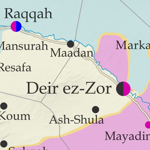
Map of Syrian Civil War (Syria control map): Fighting and territorial control in Syria in November 2017 (Free Syrian Army rebels, Kurdish YPG, Syrian Democratic Forces (SDF), Jabhat Fateh al-Sham / Hayat Tahrir al-Sham (Al-Nusra Front), Islamic State (ISIS/ISIL), and others). Includes Russia-Turkey-Iran agreed de-escalation zones and US deconfliction zone, plus recent locations of conflict and territorial control changes, such as Deir ez-Zor, Abu Kamal (Al Bukamal), Markadeh, Quriyah, and more. Colorblind accessible.Over the past few weeks, the so-called “Islamic State” (ISIS/ISIL) has been completely driven out of its last major city, Deir ez-Zor, and now only controls a few smaller towns and the surrounding desert. Its enemies, the Russia-backed Syrian government and the US-backed Syrian Democratic Forces (SDF), are both moving in to take its place.

See all this and more on the latest update to PolGeoNow’s concise, professional Syrian Civil War control map, which includes a timeline of changes since our previous Syria map report in October, with sources cited.

This map and report are premium content, available to paid subscribers of the PolGeoNow Conflict Mapping Service.

Want to see before you subscribe? Check out our most recent FREE SAMPLE Syria map!

Exclusive map report includes:

  • Up-to-date illustration of current territorial control in Syria, color-coded for the Assad government, rebel groups, “Islamic State” (ISIS/ISIL) fighters, and Kurdish/SDF forces. Colorblind accessible.
  • Markers showing the approximate locations of Russian-Turkish-Iranian “de-escalation zones” and the one known US “deconfliction zone”.
  • Special symbols indicating towns dominated by rebels of the former Al Qaeda Nusra Front (now Hayat Tahrir al-Sham) and US-backed Syrian Democratic Forces (SDF).
  • Detailed indication of city-by-city control, including key towns and other locations important to current events.
  • Locations of recent fighting and other important events, including Deir ez-Zor, Abu Kamal (Al Bukamal), Markadeh, Quriyah, and more.
  • Detailed timeline of important events and changes to territorial control since October 26, 2017, compiled by our Syria-Iraq expert, with links to sources.

SUBSCRIBERS CLICK HERE TO PROCEED TO ARTICLE AND MAP

Not signed up yet? Click here to learn more about our professional subscription service!

Can I purchase just this map?
This map and report are not available for automated purchase to non-subscribers. If you need access or republication rights for only this map report, contact service@polgeonow.com for options.

Catalonia Declares Independence from Spain: What Now?

This report is part of our Referendum 2017 coverage, spotlighting disputed independence votes for Kurdistan in Iraq and Catalonia in Spain, plus less-controversial self-rule referendums in three areas of Italy.

Catalonia and Spain: Map of Catalonia's location within Spain and relative to neighboring countries, including Spanish capital Madrid and Catalan capital Barcelona.
Map by Evan Centanni, based on this map by Mutxamel. License: CC BY-SA

By Evan Centanni

Declaration of Catalan Independence

Catalonia, a self-governed region within Spain, has declared an independent “Catalan Republic” nearly a month after holding a controversial independence vote, despite powerful opposition from the Spanish government.

The declaration was made on Friday, October 27, after the region’s parliament – elected legally under the Spanish constitution but now defying it – voted 70-10 in favor of independence. Anti-independence parties boycotted the vote, but 70 votes is enough that the motion would have passed either way, since the body has a total of 135 members.

Notably, Catalonia’s pro-independence lawmakers chose to declare it a “republic”, in contrast to Spain, which is not a republic but a constitutional monarchy (both are forms of democratic government).

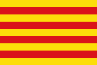
Flag of the autonomous community of Catalonia Short Name:  
• Catalonia (English)
• Catalunya (Catalan)
• Cataluña (Spanish)
• Catalonha (Occitan)
Full Declared Name:
• Catalan Republic (English)
• República Catalana (Catalan, Spanish)
• Republica Catalana  (Occitan)
Capital: Barcelona
Status According to Spain: Autonomous Community & Nationality within the Kingdom of Spain

Spain’s Political Intervention

The same day the independence declaration was made, Spain’s legislature followed up on its promise to implement direct rule in Catalonia, officially suspending the region’s president and other officials while dissolving the regional parliament. The Spanish government called new Catalan parliamentary elections for December 21. But it’s hard to say whether Catalonia’s officials and institutions will obey the orders, or how that election might go.

What Happens Next?

Spain, the Catalan people, and the world are still waiting to see what the members of Catalonia’s officially-deposed government will do. Nearly half of the region’s parliament has already signaled its compliance with Spanish courts by sitting out of the independence vote, but it’s unclear whether the rest of the body plans to step down as ordered.

Fired Catalan president Carles Puigdemont gave a speech on Saturday as if he were still in office, but without explicitly saying that he would defy the orders (potentially a crime that could land him a 30-year prison sentence). Whether the rest of the region’s officials will hand over control to the Spanish central government also remains to be seen.

Learn More: What is Catalonia, and why would it want independence?

The leader of Catalonia’s autonomous police force, for one, reportedly stepped down almost immediately yesterday. The force had wiggled its way out of helping shut down the independence vote on October 1, but without openly defying the Spanish government. This new gesture of compliance helps play down any threat of a standoff between local and national police, which is consistent with the independence movement’s commitment to non-violent tactics.

One proposed flag for an independent Catalonia
A popular proposal for the flag of an independent Catalonia. Graphic by Huhsunqu (CC BY-SA; source)

On that note, pro-independence leaders have called for mass civil disobedience from the Catalan people, which could mean street protests plus government employees refusing to take orders from Spain. But right now, it’s still too early to say what will actually happen.

Will Catalonia Become a Country?

It’s uncertain enough whether independence supporters can hold onto control of Catalan government institutions. But if they can, does that make Catalonia a real country? Not necessarily. To be accepted into the world community, an independence declaration has to be “recognized” by other countries. Without that, Catalonia wouldn’t be able to get into the United Nations (UN), the European Union (EU), or other important international organizations, and diplomats would be obliged to ignore it.

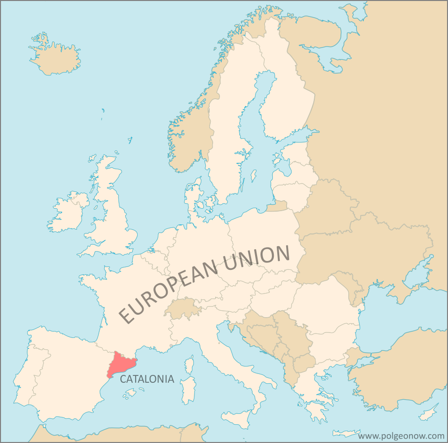
Where is Catalonia on a map? Map of Catalonia's location within the European Union (EU) and Europe
Catalonia’s place in the EU – which it would likely loose if was recognized as independent. Map by Evan Centanni, from this blank map by Ssolbergj. License: CC BY-SA

So far, things aren’t looking good for supporters of the Catalan Republic. No other country has yet granted it recognition, and only a few have even come close to expressing interest. There’s been speculation that some maverick governments, like Venezuela and North Korea, might do it, but so far the only places that have even publicly offered are Abkhazia and South Ossetia, two controversial self-declared countries that only have a few recognitions of their own. And even major would-be countries like Palestine and Kosovo, who are recognized by over half the world, still don’t have full membership in the UN, so a handful of recognitions isn’t going to cut it.

And beyond the issue of the local government obedience to Spain, there’s also the question of military and police control. Self-declared countries like Abkhazia and South Ossetia, or even completely unrecognized ones like Transnistria or Somaliland, take what credibility they have from demonstrating that their own armed forces control access to their territories and enforce the rule of law within them. But it will be very difficult for Catalonia to create a similar situation in it’s own territory, especially since no one seems to want a civil war. Spain’s police and national guard would have to first withdraw from Catalonia, and it seems unlikely that would happen without a negotiated agreement between Catalan separatists and the Spanish government.

Stay tuned to PolGeoNow and the PolGeoNow Twitter feed to find out what happens in Catalonia! You can click here to view all Referendum 2017 articles


Graphic of current Catalan flag by Wikimedia Commons user Martorell (License: CC BY-SA; source).

Syrian Civil War Map & Timeline: SDF Captures Raqqah – October 2017 (Subscription)

SUBSCRIBERS CLICK HERE TO PROCEED TO ARTICLE AND MAP

There are newer versions of this map available. To see them, view all Syria updates.

Research by Djordje Djukic. Map by onestopmap.com, Evan Centanni, and Djordje Djukic

Subscribe for full access to all conflict map reports!


Map of Syrian Civil War (Syria control map): Fighting and territorial control in Syria in October 2017 (Free Syrian Army rebels, Kurdish YPG, Syrian Democratic Forces (SDF), Jabhat Fateh al-Sham / Hayat Tahrir al-Sham (Al-Nusra Front), Islamic State (ISIS/ISIL), and others). Includes Russia-Turkey-Iran agreed de-escalation zones and US deconfliction zone, plus recent locations of conflict and territorial control changes, such as Deir ez-Zor, Maadan, As Suwar, Aqerabat, and more. Colorblind accessible. In the past month, the so-called “Islamic State” (IS; formerly ISIS/ISIL) has lost its former capital city and other key sites to the US-backed Syrian Democratic Forces (SDF), even as government troops have advanced against it in Deir ez-Zor, Hama, and Homs provinces.

See all this and more on the latest update to PolGeoNow’s concise, professional Syrian Civil War control map, which includes a timeline of changes since our previous Syria map report in September, with sources cited.

This map and report are premium content, available to paid subscribers of the PolGeoNow Conflict Mapping Service.

Want to see before you subscribe? Check out our most recent FREE SAMPLE Syria map!

Exclusive map report includes:

  • Up-to-date illustration of current territorial control in Syria, color-coded for the Assad government, rebel groups, “Islamic State” (ISIS/ISIL) fighters, and Kurdish/SDF forces. Colorblind accessible.
  • Markers showing the approximate locations of Russian-Turkish-Iranian “de-escalation zones” and the one known US “deconfliction zone”.
  • Special symbols indicating towns dominated by rebels of the former Al Qaeda Nusra Front (now Hayat Tahrir al-Sham) and US-backed Syrian Democratic Forces (SDF).
  • Detailed indication of city-by-city control, including key towns and other locations important to current events.
  • Locations of recent fighting and other important events, including Raqqah, Deir ez-Zor, Mayadin (Mayadeen), As Suwar, the Al Omar oil field, and more.
  • Detailed timeline of important events and changes to territorial control since September 27, 2017, compiled by our Syria-Iraq expert, with links to sources.

SUBSCRIBERS CLICK HERE TO PROCEED TO ARTICLE AND MAP

Not signed up yet? Click here to learn more about our professional subscription service!

Can I purchase just this map?
This map and report are not available for automated purchase to non-subscribers. If you need access or republication rights for only this map report, contact service@polgeonow.com for options.

Referendum 2017: Three Autonomy Votes in Italy Today

This report is part of our Referendum 2017 coverage, spotlighting votes on the political status of Kurdistan in Iraq, Catalonia in Spain, and now three areas of Italy. However, these latest votes are much different from the controversial ones we’ve covered in the last month…

Update: All three referendums have passed. In Lombardy, 95% of participating voters favored autonomy, but with only 39% turnout; and in Veneto, autonomy won support from 98% of voters with 57% turnout, meeting the minimum 50% turnout requirement. Nearly 99% of participants in Belluno province supported autonomy within the Veneto region, with 52% turning out to vote.

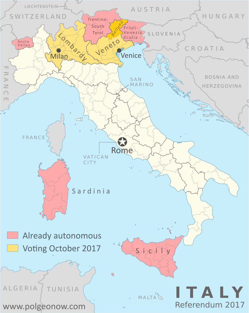
Veneto and Lombardy referendum: Map of Italy showing which regions already have special forms of autonomy, and which regions are voting on whether to request more autonomy in October 2017, which include the cities of Venice and Milan. Also marks Belluno province, which is holding its own referendum on more autonomy from the Veneto region. Colorblind accessible.
Map by Evan Centanni, based on blank map by TUBS and NordNordWest (Wikimedia Commons). License: CC BY-SA

Where are referendums happening?

Referendums are being conducted today in two of Italy’s top level “regions” (something in between a province and a US-style state). Both of them are located in the north of the country: Lombardy, which includes the city of Milan, and Veneto, which includes the city of Venice. These two regions are voting on whether to negotiate increased self-rule with the Italian national government through a framework set out in the constitution.

A third referendum is happening in the province of Belluno, part of the Veneto region, on whether to ask for more self-rule from the regional government in Venice. Belluno is a mountainous province at the northern end of the Veneto region, sharing a border with Austria.

Yet another referendum question, on whether the city of Venice proper should separate from its province to get more control over tourism and its environmental impacts, was excluded from the ballots amid uncertainties about its legality.

So are Lombardy and Veneto voting on independence?

No. Unlike controversial referendums in Catalonia and Kurdistan this past month, these votes are not about breaking off from Italy, but about asking for increased local government powers within the country. Also unlike Catalonia and Kurdistan’s votes, these have all been accepted as legal under Italian law.

In the past, the Northern League political party behind the Lombardy and Veneto referendums has called for full independence, and even for the whole of northern Italy to break off as “Padania“. People associated with it held a controversial online independence vote for Veneto in 2014. But after Italian courts struck down plans for an official vote on Venetian independence, the party decided instead to support these less-controversial votes on increased self governance.

What exactly are people voting on?

Catalonia and Spain: Map of Catalonia's location within Spain and relative to neighboring countries, including Spanish capital Madrid and Catalan capital Barcelona.
The Spanish region of Catalonia held a much more controversial status vote this month.

The ballot questions for the two regions are:

VENETO: Do you want Veneto to be given further forms and particular conditions of autonomy?

LOMBARDY: Do you want the Lombardy Region, in the framework of national unity, to start the necessary institutional initiatives to ask the state for the devolution of additional particular forms and conditions of autonomy, with the corresponding resources, in the way and for the purposes provided in Article 116, Paragraph 3 of the constitution?

Article 116 of the Italian constitution gives special powers of self-rule to five of Italy’s regions, but Veneto and Lombardy are not among them. However, it also states that other regions can be granted autonomous powers in certain areas, such as health, education, transportation, environmental protection, and foreign trade. Northern League politicians have also called for more local control of immigration, security, and national taxes levied on their residents, but those powers can’t legally be given to regional governments unless the Italian constitution is changed first.

The ballot question for Belluno province is:

Do you want the distinctness of the Province of Belluno to be further strengthened by the recognition of additional functions and related financial resources, and for this to also be implemented within the framework of the state/region agreements for greater autonomy of Veneto pursuant to Art. 116 of the constitution?

Residents will vote in the Belluno referendum and the Veneto referendum at the same time, using two separate ballots at the same polling place.

Why are these referendums happening?

Catalan referendum 2017 map: Detailed, municipality-level map of results in Catalonia's disputed October 2017 referendum on independence from Spain, showing proportion of YES votes in favor of independence in each municipality. Boundaries of comarques (comarcas) shown. Labels cities of Barcelona, Tarragona, Lleida, and Girona. Colorblind accessible.
Official results of Catalonia’s disputed independence referendum (click for more maps)

Veneto and Lombardy are among the wealthiest regions in Italy, with about 20% of the country’s GDP coming from Lombardy and 10% from Veneto. Italy has 20 regions, so the average region is responsible for only 5% of national GDP. As with Catalonia in Spain, that means many Lombards and Venetians feel they’re unfairly contributing more to the country than they’re getting back.

And that’s become even more of an issue recent years, since the Italian government has centralized financial management as part of austerity measures meant to help recover from the financial crisis of the last decade. Not to mention many Lombards, and especially Venetians, feel they’re culturally different from the rest of Italy anyway.

The Italian constitution also says regions have to first ask for more autonomy before it can be granted to them, though actually putting it up to a vote is widely believed to be unnecessary (the regional governments could just request negotiations with the national government without holding a vote).

Because of this, many people, including at least one major opposition party, see the vaguely-word referendums as a publicity stunt for the the Northern League ahead of elections next year. Still, the process has won support from a wide range of politicians going far beyond the right-wing factions that the Northern League is usually associated with.

Belluno’s referendum, on the other hand, was the idea of the province’s Socialist Party president, with local non-partisan officials enthusiastically supporting the effort after that president was voted out of office. Though this could be a way for the province to distance itself from the Veneto region’s right-leaning Northern League government, it was planned with that administration’s full approval and cooperation.

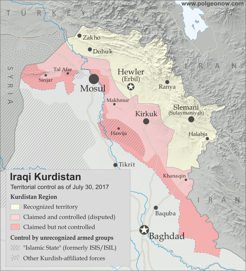
Map of Iraq and Kurdistan's place within it, published in advance of the 2017 Iraqi Kurdistan independence referendum. Includes disputed territories and territorial control as of July 30, 2017. Colorblind accessible.

Will the referendums pass?

The questions in the regional referendums are widely considered to be “no-brainers” for Lombards and Venetians – an obvious “YES” – with about 70% of voters expected to come out in support of increased self-governance. However, turnout is expected to be low, maybe around 40%, and Veneto’s referendum rules require a 50% turnout for the measure to pass.

Support for Belluno’s referendum is not well documented, and PolGeoNow has not been able to find any polling figures. (But see the top of this article for updates on real results!)

What happens next?

None of the three Italian referendums is legally binding: The regional governments can technically still request autonomy negotiations or not either way. But if they pass, it’ll be a political win for the local governments, and for the Northern League in particular. That might help them negotiate self-governance with more confidence, and could also encourage other regions to follow the same path.

Want to know more about the status referendums in Catalonia, Kurdistan, and Italy? View all Referendum 2017 articles by clicking here. And make sure to follow us on Twitter for updates on related events as they develop!

Iraq Control Map & Timeline: Government Takes Kirkuk from Kurdistan – October 2017

There are newer versions of this map available. To see them, view all Iraq updates.

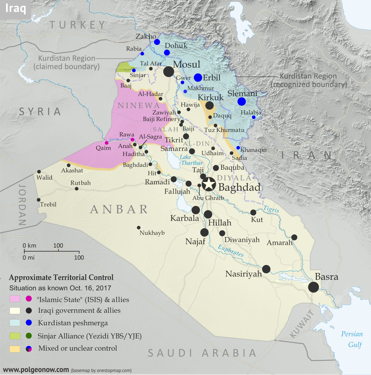
Detailed map of territorial control in Iraq as of October 16, 2017 after the recapture of Hawija and Tal Afar and government seizure of Kirkuk. including territory held by the so-called Islamic State (ISIS, ISIL), the Baghdad government, the Kurdistan Peshmerga, and the Yezidi Sinjar Alliance (YBS and YJE). Colorblind accessible.
Basemap by Koen Adams of onestopmap.com, with territorial control by Evan Centanni and Djordje Djukic. All rights reserved.

(Subscribers click here to view this article in the member area)

Timeline by Djordje Djukic

Summary of Events
Since our previous Iraq control map update in late July, there have been big changes to territorial control in Iraq, all involving expansions of control for the Iraqi military and its close allies (mainly police and Iran-backed militias): The so-called “Islamic State” (IS; formerly ISIS/ISIL) has been driven out of its Tal Afar and Hawija enclaves, and the disputed city of Kirkuk has been retaken from Kurdish forces in response to the controversial Kurdistan independence referendum. Iraqi government forces have also begun to chip away at the remaining swath of IS territory in the countryside of Anbar province, capturing the town of Anah on the road to the Syrian border.

In addition to the elimination of the fully-surrounded IS enclaves in Tal Afar and Hawija, the government recapture of those two areas also means that, for the first time since at least 2014, Iraqi Kurdistan doesn’t share any “borders” with IS territory.

See Also: Syrian Civil War Control Map – September 2017

Flag of IraqCountry Name:  
• Iraq (English, Kurdish)
• al-‘Irāq (Arabic)
Official Name:  
• Republic of Iraq (English)
• Jumhūriyyat al-‘Irāq (Arabic)
Komara Iraqê (Kurdish)
Capital: Baghdad

Timeline of Changes in Territorial Control
The following is an outline of territorial control changes and other major events since PolGeoNow’s previous Iraq map update of July 30, 2017. The abbreviation “IS” refers to the organization calling itself the “Islamic State”, also known as ISIS or ISIL. The Peshmerga are the military forces of self-governed Iraqi Kurdistan.

August 7, 2017
The pro-government Iraqi Shiite militia known as the Popular Mobilization Units (PMU) was attacked by IS close to the border with Syria in the Akashat area. Between 40 and 68 Shiite militiamen were killed in the attack. The militia accused the US-led coalition of hitting its positions with artillery bombardment from across the border. The coalition denied this.

August 15, 2017
The Iraqi military began conducting airstrikes against IS positions in the Tal Afar area, one of two remaining IS-controlled enclaves bordering Kurdistan Peshmerga territory, in preparation for a ground assault.

August 15-17, 2017
A Kurdish delegation to Baghdad refused to postpone Iraqi Kurdistan’s independence referendum, planned for September 25, as it met with Iraq’s Prime Minister and the embassies of the United States, Iran, and Turkey. The next day, the Turkish Foreign Minister and a presidential spokesman voiced strong opposition to the planned referendum, with the minister warning that the move could lead to civil war. On August 17, the Kurdish delegation said Kurdistan could delay the vote on independence “for a short time” if the Iraqi government, under an internationally-backed framework, promised to set another date for the referendum. Later, a senior Kurdish official said the region would consider the possibility of a postponement in return for financial and political concessions from the Iraqi government.

August 20-23, 2017
The Iraqi military launched a ground offensive against IS-held Tal Afar, capturing several villages east, southwest, and northwest of the town. Overall, 10 villages were reported seized by a combination of Iraqi Army, police, and PMU units on the first day of the offensive. On August 22, Iraqi forces breached Tal Afar’s city limits from the south and east, capturing three neighborhoods and more than 70 percent of a fourth one by the next day. By this time, government forces had also taken control of 15 villages around the town.

August 25, 2017
Iraqi forces reached Tal Afar’s city center.

August 27, 2017
Iraqi government troops captured Tal Afar, with IS fighters pushed out to a small town 11 kilometers northwest of the city, where they were making their last stand.

August 30-31, 2017
Fighting in the town near Tal Afar was reported to be “multiple times worse” than the battle for Mosul, as Iraqi forces faced fierce IS resistance in house-by-house fighting. The next day, the Iraqi Prime Minister declared victory over IS in Tal Afar and the whole of Ninewa (Nineveh) province, although pockets of IS resistance remained in the town. Overall, 115 Iraqi soldiers were killed and 679 wounded during the Tal Afar offensive, while Iraq claimed 2,000 IS fighters were killed. In contrast, the US reported only 1,000 to 1,200 IS fighters killed.

September 14, 2017
Some 84 people were killed and 93 wounded, including at least seven Iranian pilgrims, in a double IS attack on a restaurant and a security checkpoint near Nasiriyah in Iraq’s south. The three or four attackers, who were all also killed, were reportedly dressed as pro-government Shiite militiamen.

September 16, 2017

Control in Syria, late September 2017

The Iraqi military launched an operation against IS in the Akashat area, near the southern part of the Syrian border. Soon afterwards, the region was secured.

September 19-21, 2017
The Iraqi military launched an operation towards IS-held Anah in Anbar province. Two days later, security forces captured Anah.

September 21, 2017
The Iraqi Army attacked the Hawija pocket of IS territory, the last remaining IS enclave bordering Kurdish-held territory, capturing 11 villages.

September 23-24, 2017
Iraqi forces captured two more villages in the Hawija district, including Zawiyah. The next day, the first phase of the Hawija offensive was declared concluded.

September 25-27, 2017
Iraqi Kurdistan voted in a controversial referendum on independence from Iraq. The results were announced two days later, with 92.7% voting in favor of independence. Some 72% percent of the Kurdish region’s 8.4 million strong population voted. The region’s government did not immediately declare independence, promising instead to begin negotiations with Iraq’s central government in Baghdad.

In response to the vote, Baghdad threatened to close Kurdish airspace, while Turkey was considering shutting down its border with the region and imposing a trade ban. The Iraqi Prime Minister appeared to rule out military action, even though some Iraqi leaders warned of this, particularly in regards to Kirkuk, and Iraq’s parliament approved the use of force as part of a resolution condemning the referendum.

Kurdistan Referendum Coverage: For more information, check out PolGeoNow’s article on the results and consequences of the Kurdistan referendum, and follow us on Twitter for news on how the situation is continuing to play out.

September 29-October 3, 2017
Iraqi security forces launched the second phase of their offensive in the Hawija area, quickly capturing 70 square kilometers of territory west of Hawija town. By October 2, 45 villages were captured, and on the same day, Iraqi security forces seized another five villages and an airbase in a new assault. More areas were captured on October 3.

October 4-6, 2017
The final assault on Hawija was launched, with Iraqi security forces entering the town’s outskirts. The next day, Iraqi troops captured Hawija, though fighting continued in a pocket of IS territory north and east of the town. It was reported that over the previous three or four days, 1,000 IS fighters had surrendered in the area. On October 6, Iraqi security forces cleared the whole Hawija district of IS and linked up with nearby Kurdish Peshmerga forces after capturing the last 20 villages in the area.

Map of Iraq and Kurdistan's place within it, published in advance of the 2017 Iraqi Kurdistan independence referendum. Includes disputed territories and territorial control as of July 30, 2017. Colorblind accessible.

October 13, 2017
Thousands of Kurdish Peshmerga troops were sent to reinforce the Kurdish-held city of Kirkuk, amid a standoff with Iraqi troops over Kurdistan’s controversial independence referendum. Kirkuk is a territory long disputed between the Kurdistan region and Iraq’s central government. Kurdistan took control of the city after it got cut off from from the rest of Iraq during the IS takeover of 2014.

The rise in tensions came after Iraqi forces took several positions near Kirkuk, including a base west of the city that had been abandoned by Kurdish fighters. An unnamed Iraqi general stated they were advancing to retake positions that were captured by the Kurds in June 2014. By nightfall, fears of an imminent battle for Kirkuk dissipated.

October 16, 2017
Iraqi government forces launched an operation to capture the province of Kirkuk and its capital from Kurdish Peshmerga forces. Government troops quickly captured several positions south of the city, including Kirkuk’s industrial district, two major oil fields and a military airbase near the city.

A Peshmerga spokesman claimed Iraqi troops “burnt houses and killed many” in an assault on the Daquq and Tuz Khurmatu areas south of the city. Two people were confirmed killed during the day in artillery shelling in Tuz Khurmatu. Later in the day, Iraqi security forces entered and seized Kirkuk city with little resistance after a surprise withdrawal by the Peshmerga. Tens of thousands of civilians also fled the city towards Kurdish-held areas.

Meanwhile, two Turkish soldiers were killed by an improvised explosive device elsewhere in northern Iraq. The Turkish military maintains a presence in western Peshmerga territory as part of efforts to combat IS, generally with the consent of Kurdistan’s government but against the will of Baghdad. Turkish forces also sometimes launch strikes on Kurdish rebels from Turkey who take shelter on the Iraqi side of the border.

Graphic of the Iraqi flag is in the public domain (source).

Catalonia Referendum: Detailed Results in 5 Maps

This map report is part of our Referendum 2017 coverage, spotlighting controversial independence votes in two of the world’s autonomous regions: Kurdistan voted for independence from Iraq last month, and Catalonia tried to vote on leaving Spain on Oct. 1. Now we’ve mapped out Catalonia’s results in detail based on data from the regional government.
 

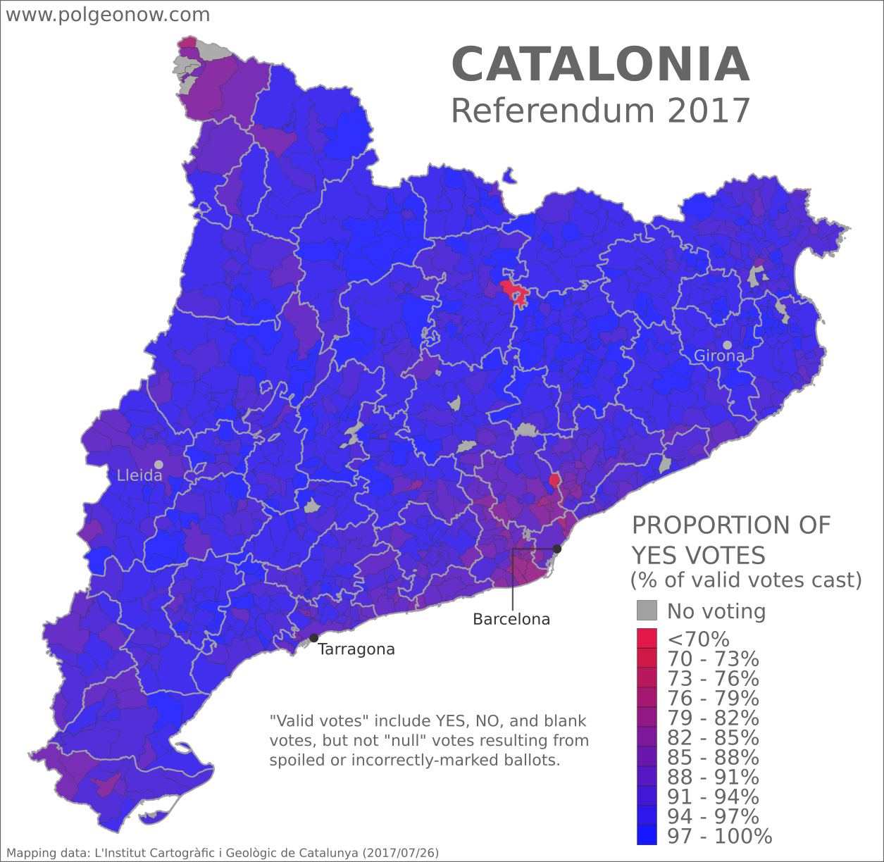
Catalan referendum 2017 map: Detailed, municipality-level map of results in Catalonia's disputed October 2017 referendum on independence from Spain, showing proportion of YES votes in favor of independence in each municipality. Boundaries of comarques (comarcas) shown. Labels cities of Barcelona, Tarragona, Lleida, and Girona. Colorblind accessible.

Controversial Independence Vote

On October 1, Spain’s autonomous region of Catalonia tried to hold a referendum on independence from Spain. After Spanish courts ruled the vote illegal, Spanish national police attempted to prevent voting, and the result was that voting was disrupted in many areas and not organized properly in most others. Still, Catalan government data states that some 42% of the region’s residents came out to vote anyway, and of those who did, about 90% voted in favor of secession. Though Catalonia’s president had promised to declare independence within 48 hours of a YES victory, so far he’s delayed doing so.

Important Note: Because Catalonia’s government encouraged voters to evade police disruptions by voting outside of their home municipalities if necessary, many smaller towns registered more votes than their total number of residents. That also means these maps should be seen more as a picture of people who voted in each municipality than of people who live in that municipality.

Municipalities are grouped by the thicker lines into county-like comarques. You can find the names of the comarques on this reference map.

Which parts of Catalonia supported independence the most, and least?

The above map shows how pro-independence voting varied between Catalonia’s 948 municipalities. Though Spanish police or other opponents managed to shut down some polling stations (shown in gray), most municipalities registered large proportions of ballots answering YES to the question, “Do you want Catalonia to become an independent state in the form of a republic?” In fact, no municipality’s votes came in with less than 64% in favor of independence.

Rural areas tended to register higher proportions of YES votes than urban areas, with concentrations of NO votes clustered in two key areas: (1) the suburbs of Barcelona, Catalonia’s largest city and most diverse area, and (2) the Aran Valley at Catalonia’s northwestern tip, an isolated area separated from the rest of Catalonia by the Pyrenees Mountains, where people traditionally speak a language called Aranese instead of Catalan. These larger patterns support the common wisdom that support for Catalan independence comes mainly from people who speak the Catalan language.

There were ten municipalities where YES to independence received a whole 100% of the vote. Meanwhile, the two towns standing out in bright red, for low proportions of YES votes, are Borredà in the north and Palau-solità i Plegamans in the south. Here are the municipalities with the highest and lowest proportions of votes for independence:

Highest Proportion of YES Votes

  1. La Pobla de Lillet (100%)
  2. Vilamaniscle (100%)
  3. Bell-lloc d’Urgell (100%)
  4. Cabó (100%)
  5. Cava (100%)
  6. Guimerà (100%)
  7. Linyola (100%)
  8. Montoliu de Segarra (100%)
  9. Sant Guim de la Plana (100%)
  10. Sidamon (100%)
Lowest Proportion of YES Votes

  1. Borredà (64%)
  2. Palau-solità i Plegamans (70%)
  3. Badia del Vallès (74%)
  4. Bausen – Aran Valley (77%)
  5. La Llagosta (77%)
  6. Santa Coloma de Gramenet (79%)
  7. Barberà del Vallès (79%)
  8. Viladecans (78%)
  9. Esplugues de Llobregat (78%)
  10. El Prat de Llobregat (81%)
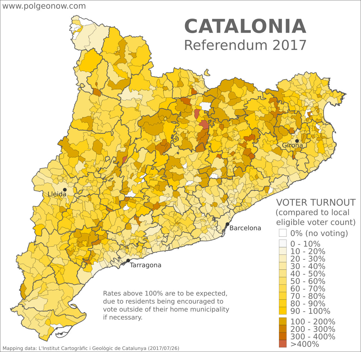
Catalan referendum 2017 map: Detailed, municipality-level map of reported voter turnout in Catalonia's disputed October 2017 referendum on independence from Spain. Labels cities of Barcelona, Tarragona, Lleida, and Girona. Boundaries of comarques (comarcas) shown. Colorblind accessible.

Where in Catalonia was voter turnout highest, and lowest?

As seen in the yellow-shaded map above, voter turnout varied across Catalonia’s municipalities, ranging from zero turnout where polling stations were shut down, all the way up to…well, over 700%. Though some opponents of the referendum have jumped on these figures as evidence of election fraud, turnout of over 100% was actually expected in many municipalities because of the unusual structure of the referendum. Anticipating police interference, Catalonia’s government allowed people to vote at any polling station where they were able to, even outside their home municipality. As such, voter turnouts over 100% neither prove nor disprove accusations of vote rigging or multiple voting by pro-independence activists.

There were 13 municipalities where voting never occurred at all, shown in pure white on the above map. According to the Catalan government, these are municipalities where “voting was not possible because of police action,” though it’s not clear how much effort was really made to hold the vote in the Aran Valley at Catalonia’s northern tip, where support for independence is reportedly very low.

Municipalities with no voting: 

  1. Callús (central Catalonia)
  2. Castellgalí (central Catalonia)
  3. Granera (central Catalonia)
  4. Estaràs (central Catalonia)
  5. Forès (central Catalonia)
  6. Sant Cebrià de Vallalta (E. of Barcelona)
  7. Garrigàs (E. of Girona)
  8. Sant Miquel de Fluvià (E. of Girona)
  9. La Tallada d’Empordà (E. of Girona)
  10. Arres (Aran Valley)
  11. Es Bòrdes (Aran Valley)
  12. Bossòst (Aran Valley)
  13. Canejan (Aran Valley)

As with high proportions of YES votes in the previous map, areas of low voter turnout are clustered around urban areas and the Aran Valley, though in this case stretch out more uniformly across much of the coast, and are just as prevalent in the Tarragona area as in Barcelona. Meanwhile, high turnout was the norm across much of Catalonia’s rural interior. Here are the municipalities with the highest and lowest turnout, other than those where polling places were closed:

Highest Reported Voter Turnout

  1. La Quar (793%)
  2. La Nou de Berguedà (521%)
  3. Cabanabona (402%)
  4. Gisclareny (378%)
  5. Urús (366%)
Lowest Reported Voter Turnout

  1. Sant Carles de la Ràpita (3%)
  2. La Pobla de Lillet (3%)
  3. Montoliu de Segarra (4%)
  4. Sant Andreu de la Barca (15%)
  5. Mont-roig del Camp (16%)

Note that some of the municipalities with over 100% turnout are located near towns where voting was completely shut down. This could be the result of people blocked from voting traveling to nearby municipalities to cast their ballots. Of course, the magnitude of an effect like that might vary depending of whether neighboring municipalities have comparatively large or small populations to begin with. Which brings us to our next map…

Catalan referendum 2017 map: Detailed, municipality-level map of eligible voter population at the time of Catalonia's October 2017 disputed referendum on independence from Spain. Labels cities of Barcelona, Tarragona, Lleida, and Girona. Boundaries of comarques (comarcas) shown. Colorblind accessible.

How many voters live in Catalonia’s municipalities?

Voter turnout is calculated by dividing the total number of ballots cast by the number of eligible voters who live in an area. And as seen in this map, the reported eligible voting population of Catalonia’s municipalities varies immensely, from as few as 25 people in tiny Sant Jaume de Frontanyà to as many as 1.14 million in Barcelona proper.

Comparing with the previous maps, we can see that both low voter turnout and low proportions of votes for independence generally correlate to highly populated areas, while high turnout and high rates of YES votes correlate with less-populated areas (the city of Girona is a notable exception, with a high population and relatively low voter turnout, but a very high proportion of support for independence).

It’s also clear that municipalities reporting voter turnout over 100% are mostly low-population areas. In fact, nearly all of them reported eligible voter populations of under 500 people. Notable exceptions – and the only ones with voter populations over 1,000 – are Polinyà (5,910 people / 173% turnout), Palau-solità i Plegamans (10,891 people / 142% turnout), and Sant Quirze del Vallès (14,531 people / 109% turnout). These three municipalities are visible in the yellow voter turnout map as the three over-100% turnout areas closest to Barcelona, all located near each other on the edges of the highly-populated metropolitan area.

This is consistent with the hypothesis that turnout over 100% was due mainly to voters flooding out of high-population areas and into low-population areas to cast their ballots. And in fact, a close examination of the maps shows that nearly all of the over-100% turnout municipalities directly border other municipalities with lower turnout (or no voting at all) and significantly higher populations.

Of course, low turnout across Catalonia as a whole begs the question, if we include people who didn’t leave home, what proportion of Catalans actually cast ballots for independence?

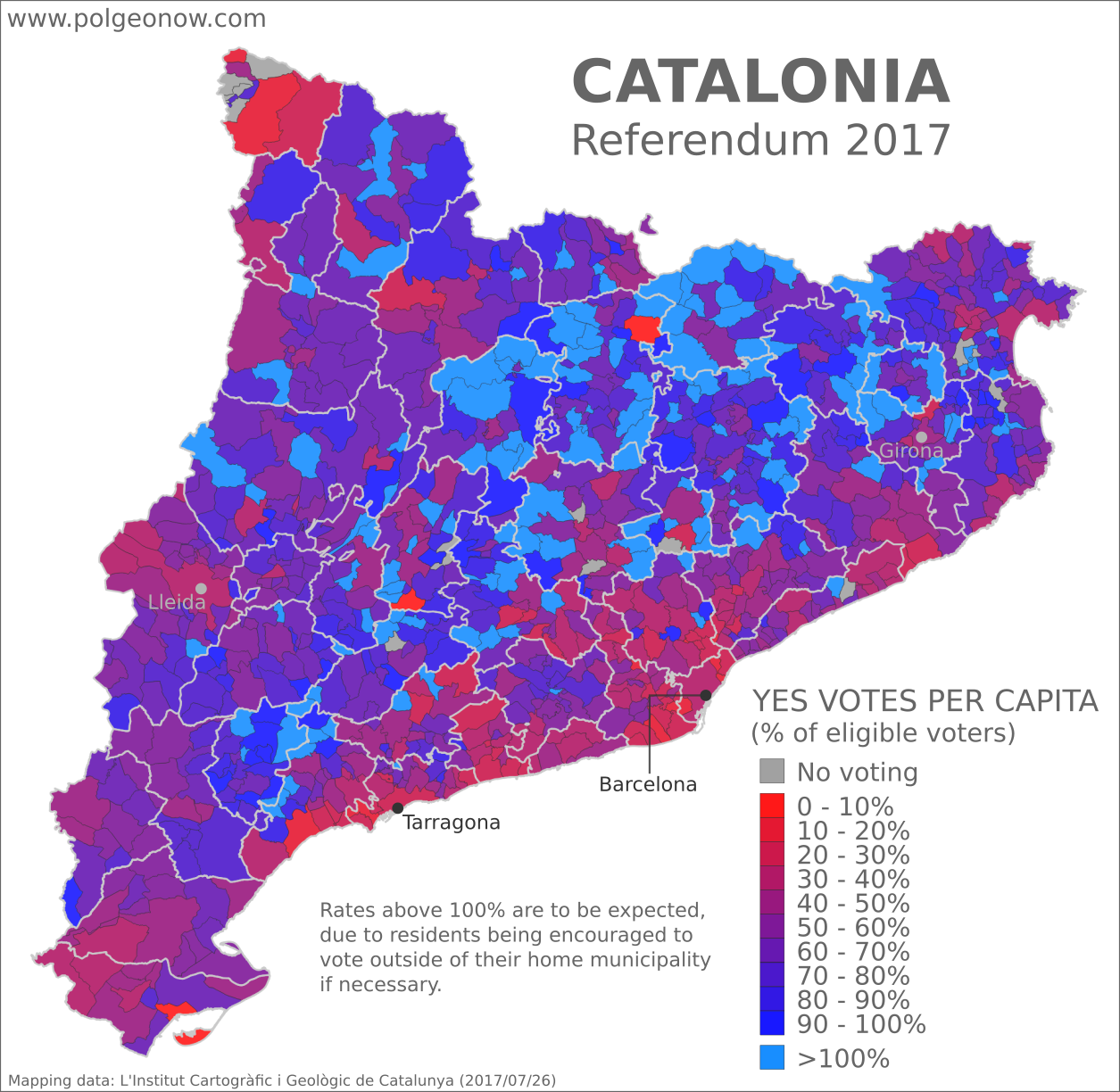
Catalan referendum 2017 map: Detailed, municipality-level map of results in Catalonia's disputed October 2017 referendum on independence from Spain, showing per capita YES votes in favor of independence as a proportion of total eligible voter population in each municipality. Boundaries of comarques (comarcas) shown. Labels cities of Barcelona, Tarragona, Lleida, and Girona. Colorblind accessible.

How many of each municipality’s people actually voted for independence?

This map, a kind of special hybrid between the YES/NO map and the voter turnout map, shows YES votes as a proportion of each municipality’s total eligible voters, rather than of valid ballots cast. If every voter had cast ballots within their home municipality, you could think of it as showing the minimum actual support for independence in each area, as if non-participants in the referendum had all voted NO. Of course, we shouldn’t assume that all non-voters are against independence – even determined pro-independence voters were sometimes prevented by police from casting ballots – but it’s likely that quite a lot of opponents sat this out, and we certainly can’t assume the opposite.

Yet as we’ve seen above, the movement of voters to other municipalities makes the situation more complicated: We can’t really determine how many people supported independence in a municipality that was flooded with 400% voter turnout from other regions, to say the least.

Still, major differences from the results map at the beginning of the article reveal some interesting patterns. For one thing, it’s clear from this map that we can’t assume a majority of Catalans actually support independence: In the highly-populated areas along the coast and around major cities, the total number of YES votes for independence was often much less than half the total number of eligible voters. Even many of the rural central municipalities show proportions not much over half, if that.

In fact, many geographical areas lost in the dark blue YES votes of the first map come out looking decidedly lukewarm about independence here, including the the area near Catalonia’s northeastern border with coastal France, as well as clumps along the boundaries of the Spanish regions of Aragon to the west and Valencia to the south. And that’s not to mention a smattering of new red spots peppered across Catalonia’s rural interior.

But while we’re on the topic of the many Catalans who don’t support independence, let’s look at one last map…

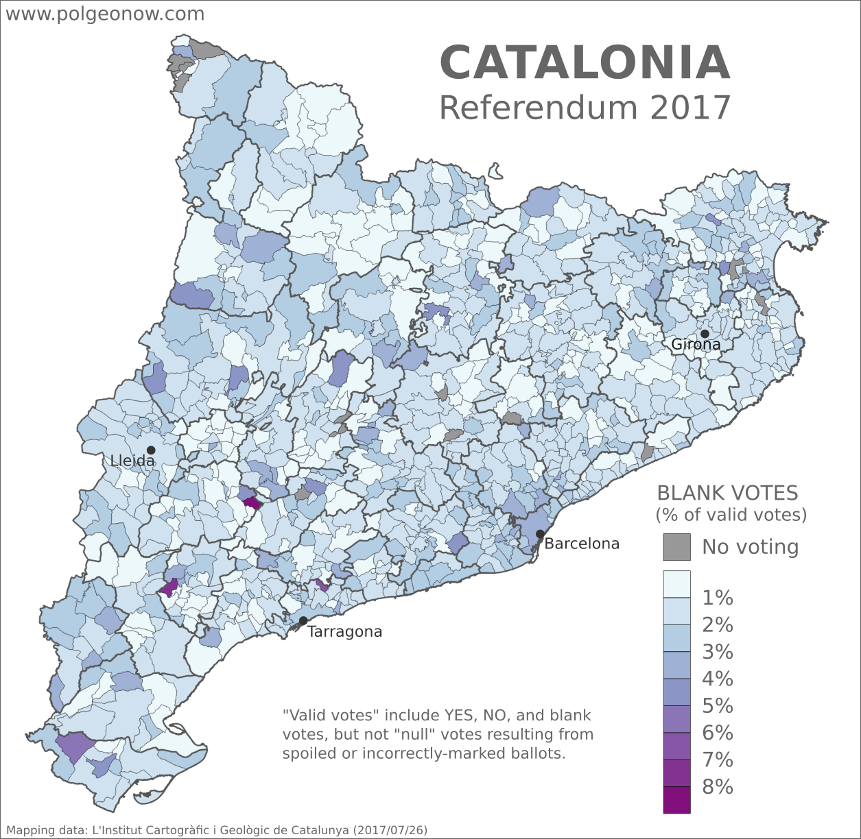
Catalan referendum 2017 map: Detailed, municipality-level map of results in Catalonia's disputed October 2017 referendum on independence from Spain, showing proportion of blank votes in each municipality. Boundaries of comarques (comarcas) shown. Labels cities of Barcelona, Tarragona, Lleida, and Girona. Colorblind accessible.

Where in Catalonia did people cast blank ballots?

During the lead-up to Catalonia’s attempted referendum, it was well-documented that many Catalans – including the mayor of Barcelona – strongly supported having a vote even though they opposed independence. Polls earlier this year put support for independence at just under 50%, while support for holding a referendum was over 70%. So it stands to reason that many anti-independence residents still made an effort to get out and vote NO.

But what about undecided voters, who neither supported nor opposed independence but felt strongly about their right to vote on it? These people may have been largely responsible for the referendum’s many reported blank votes – ballots cast without marking either the YES or the NO option on independence. And rates of blank voting varied significantly between municipalities.

In our earlier article on larger-scale referendum results, we reported that the greater Barcelona region had a much higher rate of blank votes than other regions, averaging 2.6% compared to between 1.2% and 1.6% for other regions. That’s hard to see on the municipalities map, probably because high rates of blank votes in the Barcelona region were concentrated in just a few very high-population areas (recall that the city of Barcelona, which registered just over 3% blank votes, has a population of over one million).

Variation in blank voting rates across central Catalonia don’t seem to match up with any patterns from the other maps, and may be just statistical noise related to the very small populations of many rural municipalities. Tellingly, the three municipalities colored in darkest purple, for very high rates of blank votes, all have eligible voter populations of less than 150 people, with just three to six total blank ballots cast in each one. If just one person chose not to vote blank in these municipalities, the rate would see a major drop.

It seems the main takeaway is that blank voting was a phenomenon mainly in Barcelona, more than in any other part of Catalonia. Perhaps this was a reaction to violent police crackdowns that took place in the city, or just part of the capital’s specific political culture. Interestingly, Barcelona proper also had a relatively high rate of support for independence among participating voters compared to neighboring suburbs. Meanwhile, the cities of Lleida and Girona had rates of blank votes similar to the neighboring countryside, despite registering less overall support for independence.

Learn More: What is Catalonia, and why would it want independence?

Stay tuned to PolGeoNow and the PolGeoNow Twitter feed for more updates on Catalonia’s push for independence, plus new developments around the Kurdistan referendum in Iraq. Click here to view all Referendum 2017 articles.

Updated! Catalonia Referendum Results Maps: How Did Each Region Vote?

Updated! This article’s maps and text have been updated with final results released by the Catalan government. See below for more details. We also now have an article with detailed results maps broken down by municipality.

This map report is part of our Referendum 2017 coverage, spotlighting controversial independence votes in two of the world’s autonomous regions: Kurdistan voted for independence from Iraq last week, and Catalonia voted to leave Spain this weekend. Now detailed results are available, and we’re working on getting them mapped out.

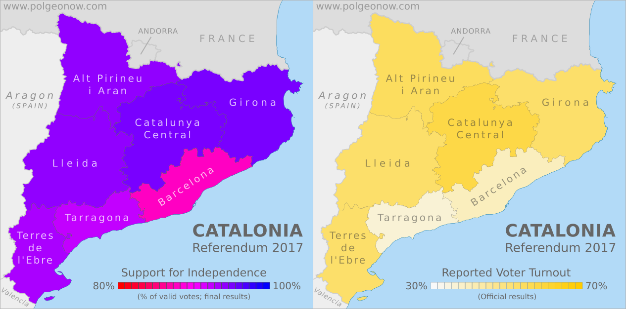
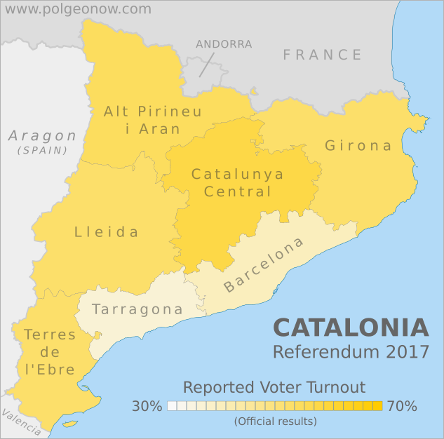
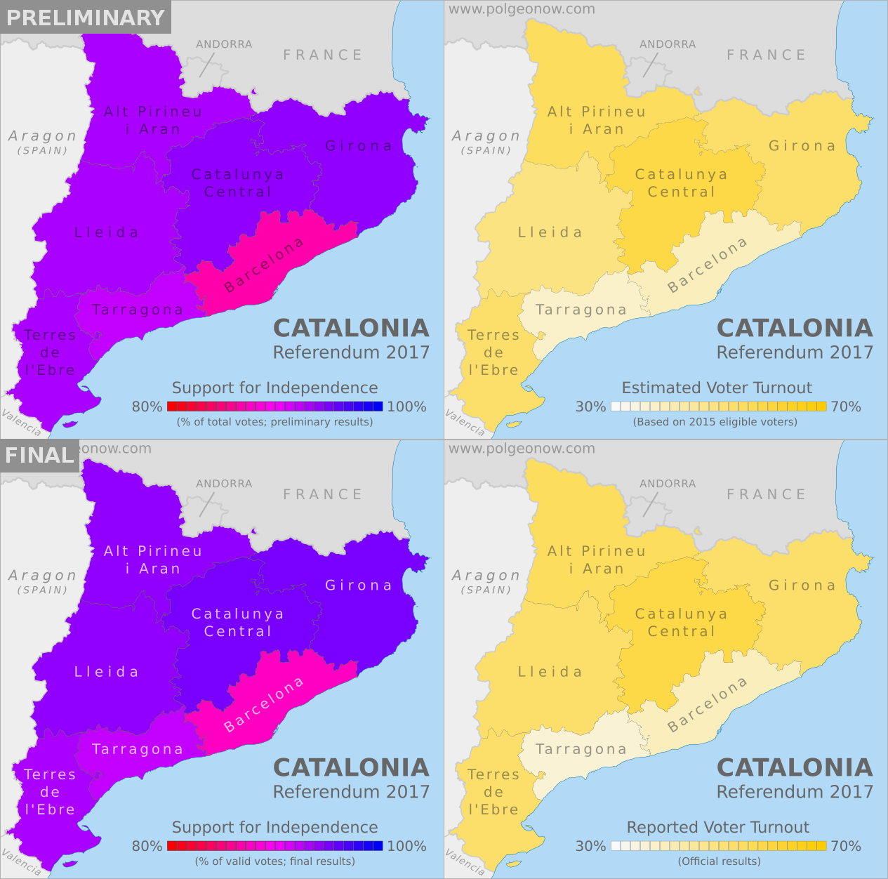
2017 Catalonia independence referendum results map. This map shows support for independence by region (vegueria) in the October 1 Catalan vote on independence from Spain. Colorblind accessible. 2017 Catalonia independence referendum voter turnout map. This map shows voter turnout by region (vegueria) in the October 1 Catalan vote on independence from Spain. Colorblind accessible.
Maps by Evan Centanni, starting from blank map by Vinals and Rwxrwxrwx. License: CC BY-SA

Catalonia Independence Vote (Updated)

Detailed, final results are now available for Catalonia’s controversial referendum on independence from Spain. The vote was widely disrupted by the Spanish police after courts ruled it illegal, resulting in massive irregularities that will make it hard for outsiders to accept as a proper democratic referendum. Still, some 43% of eligible Catalan voters reportedly made it out to cast ballots, meaning there’s plenty of reported data to look at.

These maps, originally published two days ago based on preliminary results and estimates of voter turnout, have now been updated with the final data from the Catalan government. The final results showed no change in support for independence significant enough to effect our map. However, we decided to re-do the map using the Catalan government’s official method of calculating the percentage, which excludes spoiled ballots from the total votes (the original map included these so-called “null votes” in the total votes when calculating the percentage of YES votes). This method results in slightly higher figures for all regions. We also changed the color of the region labels, because they were hurting our eyes.

The voter turnout map, originally based on estimates of eligible voters drawn from 2015 election data, has also been updated with official figures. The only two changes: Tarragona had a slightly lower voter turnout rate than we estimated, and Lleida had a somewhat higher turnout than our estimate. Click here to compare the original maps with the new versions.

Who voted for independence?

Support for independence among those managed to vote was very high, with 90% of valid votes and 89% of total ballots cast. This is unlikely to represent the actual proportion of the Catalan population that supports independence, since polls earlier this year showed the region split roughly half and half over the question. On the other hand, about three-quarters of Catalans supported the idea of at least voting on it, and after the Spanish government’s heavy-handed crackdown, it’s likely that independence has only gotten more popular.

One proposed flag for an independent Catalonia
Catalonian independence flag.  
(Graphic by Huhsunqu. CC BY-SA; source)

As seen on the left-hand map above, independence received the highest percentage of votes in Girona and the rural Catalunya Central – the referendum passed by nearly 95% in both areas. Meanwhile, in Barcelona, Catalonia’s capital and largest city, support was significantly lower, but still reached about 88% among those who voted. Barcelona is a large, diverse city, and many residents may be immigrants from other parts of Spain who don’t buy into the idea of Catalonia as a separate country.

How many people showed up to vote?

The Catalan government’s official voter turnout figures have been a matter of some controversy, since the referendum was carried out without access to the official Spanish voter rolls, amid police attempts to confiscate the regional government’s own records. In addition, to avoid the police crackdown on polling stations, residents were encouraged to vote anywhere in Catalonia that they could, even though they would normally have to go to a polling station in the municipality where they were registered. This resulted in some municipalities’ total ballot counts being higher than their actual population of eligible voters – fueling accusations of fraud by the referendum’s opponents.

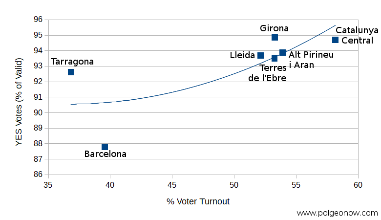
Catalonia independence referendum 2017: Scatter plot showing estimated voter turnout vs. percentage of votes for independence by region (vegueria). The results show that voter turnout was positively correlated with support for independence: Regions with higher turnout also had a higher proportion of YES votes on independence from Spain.

But that doesn’t stop us from doing an analysis of the claimed data. As seen on the right-hand map above, turnout was highest in Catalunya Central, and lowest in Tarragona and Barcelona – the same two regions that had the lowest support for independence.

And in fact, when we graphed out voter turnout versus YES votes, there does appear to be a correlation: In general, the higher voter turnout was in a given region, the more people there voted for independence (and vice versa).

Maybe this should be no surprise: It’s likely that many opponents of Catalan independence didn’t feel motivated to defy the Spanish government by voting. After all, the police were taking the opponents’ side by trying to shut down the vote and prevent independence. So you might indeed expect that people in pro-independence places would have come out to vote in bigger numbers, while people in less separatist areas would stay home.

Interestingly though, the less-separatist, low-turnout Barcelona region also had by far the highest rate of blank votes. Some 33,000 people, or 2.3% of participating voters in the metro area, didn’t write anything on their ballots – that’s compared to 1.2% to 1.6% for other areas. Given the major police efforts to block people in Barcelona from voting, it’s hard to imagine that truly unenthusiastic voters would have made it to the ballot boxes. But these blank votes could represent people who wanted defy the police crackdown by voting out of principle, even if they were undecided about actual independence.

Want to see the picture in more detail? Check out our new article with municipality-level results maps for the Catalan referendum!

Learn More: What is Catalonia, and why would it want independence?

Stay tuned to PolGeoNow and the PolGeoNow Twitter feed for more updates on Catalonia’s independence vote, plus new developments around the Kurdistan referendum in Iraq. Click here to view all Referendum 2017 articles


Graphic of current Catalan flag by Wikimedia Commons user Martorell (License: CC BY-SA; source).

Catalonia Voting on Independence: What Will Happen?

This article is part of our Referendum 2017 coverage, spotlighting controversial independence votes in two of the world’s autonomous regions: Kurdistan voted for independence from Iraq this Monday, and Catalonia is about to vote on leaving Spain. 

Update: Check out the bottom of the article for a brief summary of what’s actually happened since referendum day!

Catalonia and Spain: Map of Catalonia's location within Spain and relative to neighboring countries, including Spanish capital Madrid and Catalan capital Barcelona.
Map by Evan Centanni, based on this map by Mutxamel. License: CC BY-SA

By Evan Centanni

Catalonia Independence Vote

Catalonia, a self-governed region within Spain, is about to start voting on independence in a referendum that Spanish courts have ruled illegal. So what will happen? No one really knows, but we’ve taken our best shot at answering six of the big questions…

1. Will Catalonia’s independence vote even happen?

Amazingly, the biggest question about Catalonia’s independence vote is, “Will it even happen at all?” Catalonia’s government insists that it will, and Spain’s national government insists that it won’t. The Spanish government in Madrid has sent thousands of police to arrest organizers, confiscate ballots and ballot boxes, and close up polling stations, with local courts ordering Catalan police to help (“Catalan” is what you call someone from Catalonia).

Meanwhile, In what the New York Times described as a “game of cat and mouse“, Catalonia’s government and supporters have directly resisted the police by hiding backup ballot boxes, printing new ballots, and occupying polling sites before police can take over. It’s still too early to predict how things will go, but it seems likely voter turnout will be lower than planned, to say the least, and that the vote will be disorganized enough for its opponents to claim the results aren’t valid.

2. Will Catalonia’s people vote YES on independence?

Supporters of Catalan independence have been all over the news in recent days, but that doesn’t mean everyone in Catalonia agrees. In fact, many opinion polls show a majority against independence (but a large majority in favor of having a vote). Still, supporters of independence are more likely to vote than opponents, and YES could still take the day, especially now that the police have made voting difficult. But as far as we can say now, it could end up going either way.

Flag of the autonomous community of Catalonia Territory Name:  
• Catalonia (English)
• Catalunya (Catalan)
• Cataluña (Spanish)
• Catalonha (Occitan)
Capital: Barcelona
Official Status:  
Autonomous Community & Nationality within Spain

3. If the result is YES, will Catalonia declare independence?

This one is a little easier to answer: Carles Puigdemont, the leader of Catalonia’s regional government, has promised to declare independence within 48 hours if the people vote YES – no matter how few voters show up.

So unless the result is NO (possible), Catalonia’s government is removed from power (also possible), or someone convinces them to break the promise (less likely), we can expect a Catalan declaration of independence on Tuesday.

4. Will Spain let Catalonia go if it declares independence?

The obvious answer would seem to be “no”, since Spain’s central government has opposed the referendum at every turn, and seems desperate not to let Catalonia secede. And it certainly won’t be easy – to start with, Catalonia’s government would have to figure out how to get all the Spain-loyal police out. But it’s also hard to say what would happen if Catalonia, and its millions of people, force the issue and try to block Spain’s government from the region. Spain’s current government may never give in and accept it, but another major Spanish political party has been relatively supportive of Catalans’ desire to vote, and Catalonia is to large and wealthy for its neighbors to ignore. So it’s not inconceivable that a solution could be hammered out in the longer-term future.

5. Would Catalonia be accepted as a country by the rest of the world?

Most lists of the world’s countries only include ones that have been accepted by the United Nations (UN), or at least recognized by most of the world. So if Catalonia declares independence, will it make the grade?

One proposed flag for an independent Catalonia
Catalonian independence flag. Graphic by Huhsunqu (CC BY-SA; source)

If it could somehow work out a deal with Spain accepting secession, then the world would almost certainly accept it (like what happened with South Sudan in 2011). But if the Catalan government declares independence without Spain’s permission, as it says it will Tuesday if the vote passes, then there could be a long, difficult road ahead.

One of the best-case scenarios for Catalonia would be a situation something like Kosovo’s or Palestine’s – recognized by half of the world’s countries, with only partial participation in the UN and other international organizations.

But even Kosovo and Palestine had something going for them that Catalonia doesn’t – the US and allies supported Kosovo’s independence from the beginning, and Palestine had guaranteed support from neighboring Arab countries. Many countries say they’re neutral on the Catalan independence referendum, but none have committed to formally recognizing Catalonia as an independent country. Though it’s hard to imagine in powerful Western Europe, there’s a chance Catalonia might end up as isolated as Abkhazia or even Somaliland.

Where is Catalonia on a map? Map of Catalonia's location within the European Union (EU) and Europe
Catalonia’s place in the EU. Map by Evan Centanni, from this blank map by Ssolbergj. License: CC BY-SA

6. Can Catalonia stay in the EU?

Another big issue hanging over Catalan independence is the region’s European Union (EU) membership. Right now, all of Spain is part of the EU, including Catalonia. And as citizens of the UK know, leaving the EU is no simple matter, since member countries are heavily intertwined economically and in other ways.

So here’s the catch: For Catalonia, declaring independence probably means leaving the European Union: The EU says if Catalonia secedes from Spain, it will have to re-apply as a new member country. And since all existing EU members, including Spain, have to agree before a new applicant is accepted, it could take awhile for that to happen.

Update: What Happened?

  • The vote went forward, but was badly disrupted by Spanish police, and it won’t be seen as a legitimate democratic election result by most observers.
  • Catalonia’s government says independence won with 90% of the vote and 42% voter turnout.
  • The Catalan government missed its self-imposed 48-hour deadline to declare independence.
  • PolGeoNow has published updated election results and voter turnout maps by region, based on official data released by the Catalan government.
  • On October 10, Catalonia’s leaders signed a document declaring independence from Spain, but “suspended” it so that it wouldn’t take effect yet.
  • October 13: Check out our new detailed, municipality-level maps of the official referendum results! 
  • On October 27, Catalonia’s pro-independence administration declared full independence from Spain, and Spain’s government began trying to assert direct rule over the region.

Learn More: What is Catalonia, and why would it want independence?

Stay tuned to PolGeoNow and the PolGeoNow Twitter feed for more updates on Catalonia’s independence vote, plus new developments around the Kurdistan referendum in Iraq. Click here to view all Referendum 2017 articles


Graphic of current Catalan flag by Wikimedia Commons user Martorell (License: CC BY-SA; source).

Referendum 2017: What is Catalonia?

This article is part of our Referendum 2017 coverage, spotlighting controversial independence votes in two of the world’s autonomous regions: Kurdistan voted for independence from Iraq this Monday, and Catalonia will vote Sunday on leaving Spain. 

The following article is adapted from one originally published in 2013.

Catalonia and Spain: Map of Catalonia's location within Spain and relative to neighboring countries, including Spanish capital Madrid and Catalan capital Barcelona.
Map by Evan Centanni, based on this map by Mutxamel. License: CC BY-SA

By Omar Alkhalili, with additional reporting by Evan Centanni

Not Independent Yet: So What is Catalonia Now?

Catalonia is one of the “autonomous communities” of Spain (kind of like a state in the US), and also holds the official status of a “nationality” (but not “nation”) within the Spanish system of government. Regions of Spain with this status are considered to be something similar to countries within the larger Spanish nation, allowing for their own separateness from Spanish mainstream culture without actually being independent.

The region’s political administration includes four provinces and extends over a large part of the historical Principality of Catalonia, which also included a piece of what’s now southern France. Its capital is Barcelona, the largest city in Spain after Madrid and the sixth-largest in Europe. Catalan, Spanish, Aranese Occitan and Catalan Sign Language are all officially recognized languages in Catalonia. (“Catalan” means “from Catalonia”, like how “French” means “from France”.)

Catalonia’s History in a Nutshell

Early in Catalonia’s history, the region was ruled by Greeks, Carthaginians, Romans, Visigoths and Moors. After a period of Frankish administration, the region became a self-governing principality, ruled by the Count of Barcelona under the Crown of Aragon. It was during this time that Catalonia began producing a uniquely Catalan culture. The principality later unified with the Crown of Spain but kept self rule. However, during the War of the Spanish Succession in the early 1700s, King Philip V brought an end to Catalan self-rule, incorporating it fully under the Spanish monarchy.

Flag of the autonomous community of Catalonia Territory Name:  
• Catalonia (English)
• Catalunya (Catalan)
• Cataluña (Spanish)
• Catalonha (Occitan)
Capital: Barcelona
Official Status:  
Autonomous Community & Nationality within Spain

In the 20th century, Catalonia would have varying degrees of cultural independence. After the Spanish Civil War in the 1930s, military leader Francisco Franco banned Catalan language and culture for several decades. After World War II, Spain would see booming economic growth (the so-called the “Spanish Miracle”) with Catalonia both contributing and benefiting. With the end of Franco’s rule in 1975 came the transition from dictatorship to democracy, which resulted in Catalonia being granted political, cultural, and linguistic autonomy under the new Spanish constitution.

Catalonia and Independence

The formation of pro-independence organizations in Catalonia began in the early 20th century, with armed groups like Terra Lliure, the Catalan Liberation Front, and the Catalan Red Liberation Army later showing up too. By the mid-1990s, however, most of the violent separatist groups had disbanded. Starting in 2008, the global recession hit Spain particularly hard, and the economic downturn rejuvenated nationalist aspirations in the relatively prosperous region. Separatists especially pointed to the fact that Catalonia was contributing almost 20% of Spain’s tax revenue, while allegedly receiving less than 15% of federal government spending.

Polling in 2010 suggested that only 25% of Catalans wanted outright secession from Spain, but by 2012 that had grown to a surprising 51%. After pro-independence parties won a majority in the Catalan parliament in 2012, plans were made for a referendum on leaving Spain. A non-binding “popular consultation” vote was held in 2014 amid political and legal opposition from the Spanish government, with 81% of participants favoring Catalan independence – however, it was widely believed that opponents of independence didn’t vote at all.

One proposed flag for an independent Catalonia
Catalonian independence flag. Graphic by Huhsunqu (CC BY-SA; source)

But after pro-independence parties retained their combined parliamentary majority in 2015, the regional government set out to separate from Spain once and for all. A serious, uncompromising independence referendum was eventually scheduled for October 1, 2017, in open defiance of the Spanish government and courts. Now, the Catalan administration is struggling to make sure the vote is still held, with national police taking direct action to close polling stations and keep ballots out of residents’ hands. Even if the vote is held and independence wins, Catalonia will face a very tough and uncertain road ahead if it hopes to achieve real independent rule and recognition by other countries.

If Catalonia was Independent

How would Catalonia compare if it could became a recognized independent country now? It would have a population of 7.5 million people, making it the 101st most populous country in the world, and roughly 20th in Europe – just a bit less populous than Switzerland. The total land area of Catalonia is about 32,100 sq km (12,400 sq mi), making it roughly the 135th largest of the nearly 200 countries in the world, and 34th in Europe (about the size of Belgium).

Where is Catalonia on a map? Map of Catalonia's location within the European Union (EU) and Europe
Catalonia’s place in the EU. Map by Evan Centanni, from this blank map by Ssolbergj. License: CC BY-SA

The gross domestic product (GDP) of the Catalonia region is about US$200 billion, which would make it roughly the 45th largest national economy in the world if it were an independent country, and about 15th largest in Europe (similar to Finland). If Catalonia strikes out on its own, Spain would lose roughly 16% of its population and 6% of its territory, and its GDP would be reduced by about 20%.

Can Catalonia Join the EU?

One big issue hanging over discussions of Catalan independence is European Union (EU) membership. As citizens of the UK know, leaving the EU is no simple matter, since member countries are heavily intertwined economically and in other ways. And for Catalonia, declaring independence probably means leaving the union: The EU says if Catalonia secedes from Spain, it will have to re-apply as a new member country. Since existing EU members, including Spain, must all agree before any new applicants are accepted, the odds aren’t looking very good for Catalan membership in the near future.

Learn More: What will happen after Catalonia’s controversial independence vote?

Stay tuned to PolGeoNow and the PolGeoNow Twitter feed for more updates on Catalonia’s independence vote, plus new developments around the Kurdistan referendum in Iraq. Click here to view all Referendum 2017 articles


Graphic of current Catalan flag by Wikimedia Commons user Martorell (License: CC BY-SA; source).

Syrian Civil War Map & Timeline: Siege of Deir ez-Zor Broken – September 2017 (Subscription)

SUBSCRIBERS CLICK HERE TO PROCEED TO ARTICLE AND MAP

There are newer versions of this map available. To see them, view all Syria updates.

Research by Djordje Djukic. Map by onestopmap.com, Evan Centanni, and Djordje Djukic

Subscribe for full access to all conflict map reports!


Map of Syrian Civil War (Syria control map): Fighting and territorial control in Syria in September 2017 (Free Syrian Army rebels, Kurdish YPG, Syrian Democratic Forces (SDF), Jabhat Fateh al-Sham / Hayat Tahrir al-Sham (Al-Nusra Front), Islamic State (ISIS/ISIL), and others). Includes Russia-Turkey-Iran agreed de-escalation zones and US deconfliction zone, plus recent locations of conflict and territorial control changes, such as Deir ez-Zor, Maadan, As Suwar, Aqerabat, and more. Colorblind accessible. In the past month, the territory of the so-called “Islamic State” (IS; formerly ISIS/ISIL) has continued to shrink rapidly, with the Russia-backed Assad government and the US-backed Syrian Democratic Forces (SDF) both rushing to secure Deir ez-Zor province in Syria’s east.

See all this and more on the latest update to PolGeoNow’s concise, professional Syrian Civil War control map, which includes a timeline of changes since our previous Syria map report in August, with sources cited.

This map and report are premium content, available to paid subscribers of the PolGeoNow Conflict Mapping Service.

Want to see before you subscribe? Check out our most recent FREE SAMPLE Syria map!

Exclusive map report includes:

  • Up-to-date illustration of current territorial control in Syria, color-coded for the Assad government, rebel groups, “Islamic State” (ISIS/ISIL) fighters, and Kurdish/SDF forces. Colorblind accessible.
  • Markers showing the approximate locations of Russian-Turkish-Iranian “de-escalation zones” and the one known US “deconfliction zone”.
  • Special symbols indicating towns dominated by rebels of the former Al Qaeda Nusra Front (now Hayat Tahrir al-Sham) and US-backed Syrian Democratic Forces (SDF).
  • Detailed indication of city-by-city control, including key towns and other locations important to current events.
  • Locations of recent fighting and other important events, including Deir ez-Zor, Maadan, As Suwar, Aqerabat, and more.
  • Detailed timeline of important events and changes to territorial control since August 28, 2017, compiled by our Syria-Iraq expert, with links to sources.

SUBSCRIBERS CLICK HERE TO PROCEED TO ARTICLE AND MAP

Not signed up yet? Click here to learn more about our professional subscription service!

Can I purchase just this map?
This map and report are not available for automated purchase to non-subscribers. If you need access or republication rights for only this map report, contact service@polgeonow.com for options.