Map: Costa Rica & Nicaragua Settle Border Dispute in Court

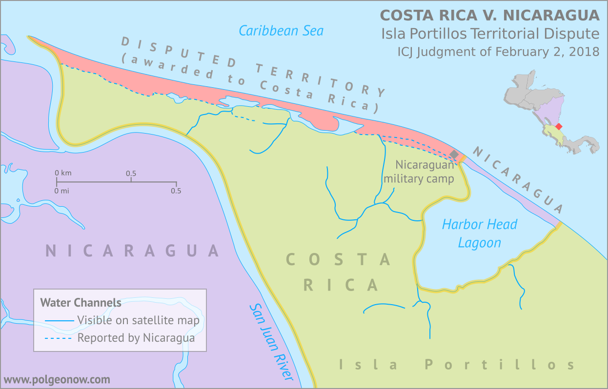
Conflicto Isla Portillos - mapa 2018. Map of Costa Rica and Nicaragua's post-2015 territorial dispute on Isla Portillos at the mouth of Rio San Juan, showing the judgment of the International Court of Justic (ICJ) of February 2018, based on the case filed in 2017. Includes key features such as Harbor Head Lagoon, the Nicaraguan military camp, the disputed territory along the beach, and the small water channels used to argue Nicaragua's case. Colorblind accessible.
Map by Evan Centanni, based on materials submitted to the court. Contact for usage permissions.

World Court Rules on Costa Rica vs. Nicaragua

What happens when two countries draw their border along a river, then the river changes course? The world got to find out yesterday, as the UN’s International Court of Justice (ICJ) released its judgement on a border dispute between Nicaragua and Costa Rica. Though the court’s ruling was dominated by a related request to define the two countries’ borders at sea, it also involved a tiny sliver of land in a temperamental river delta.

The Isla Portillos Dispute

The disputed land territory involves a slice of coastline at the northern tip of Isla Portillos, an island located in the delta of the River San Juan de Nicaragua (Isla Portillos is sometimes considered part of the larger Calero Island). The border once ran along the river and into a lagoon before hitting the Caribbean Sea, but a hundred years of natural changes to the area’s geography messed that all up.

In this court case – the latest of several between the two countries – Nicaragua claimed that a tiny channel of water still connected the river to the lagoon, separating a narrow strip of Nicaraguan coastline from the island’s Costa Rican interior. But Costa Rica argued that the channel, if it even existed, had been artificially built by Nicaragua, and that the Nicaraguan sandbar that once did exist had long ago eroded away. In this view, a small Nicaraguan military camp on the beach – recently moved from the mouth of the lagoon to a spot slightly farther west – was an illegal occupation of Costa Rican territory.
Flag of Costa Rica (civil)Country Name:  
• Costa Rica (English, Spanish)
Official Name:  
• Republic of Costa Rica (English)
• República de Costa Rica (Spanish)
Capital: San José

Costa Rica admitted that the lagoon itself, and the piece of beach now separating it from the sea, still belonged to Nicaragua, leaving a tiny piece of Nicaraguan territory separated from the rest of the country. Even so, Costa Rica warned that Nicaragua might even lose all of that if the beach erodes away completely (international law doesn’t normally allow a country to claim a body of water without owning some piece of land next to it).

Judgement Day: Who Owns the Beach on Isla Portillos?

When it released its decision this yesterday, the ICJ agreed with Nicaragua that the status of the disputed territory hadn’t already been decided by earlier court rulings. But in the end the judges sided almost entirely with Costa Rica, agreeing that the beach between the lagoon and the mouth of the river are Costa Rican. In a decision made by a vote of fourteen to two, Nicaragua was left with just the lagoon and its short strip of beach, and was ordered to move the military camp off of Costa Rican land.

In an unusual move, the court also decided that the sea just outside of the lagoon would be Costa Rican waters. Normally, any coastline controlled by a country automatically gives it the rights to at least some of the neighboring waters, and denying that to Nicaragua might turn out to be controversial.

The Story of a Border Dispute

The tale of the Isla Portillos dispute goes back almost 200 years, involving a US president, a Confederate general, and a lot of creative geographical analysis.

Costa Rica and Nicaragua declared independence from Spain together in 1821, and went their separate ways after the Federal Republic of Central America fell apart in 1838. But from early on, they scuffled over exactly which land belonged to which country. In 1858, they set out to end the disputes by precisely defining the course of their border in the Cañas–Jerez Treaty of Limits.

That treaty set the right bank of the San Juan River as the border in the Caribbean coastal area, with the boundary ending at a spot called Punta Castilla by the river’s mouth. After bringing in US President Grover Cleveland as a mediator from 1886 to 1888 to settle remaining disputes over the treaty’s validity, plus the exact location of Punta Castilla, the border seemed to be settled once and for all.

>Only one problem: Rivers change course over time. By 1896, when the Costa Rican and Nicaraguan governments set out to actually mark their border with pillars on the ground, the end of the San Juan River had split into three separate channels, hitting the ocean kilometers apart from each other. Naturally, each country chose whichever border interpretation gave it the most land, leaving the intervening islands disputed once again.

Map of the border between Nicaragua and Costa Rica at the Caribbean mouth of the San Juan River as decided by the 1897 Alexander award, including prior claims by each country. Includes Harbor Head Lagoon, the Taura Branch of the San Juan River, and the island now known as Isla Portillos.
Click to enlarge: Map of General Alexander’s 1897 border decision, and the Nicaraguan and Costa Rican claims of the time. The largest island, cut off by the Taura Branch, is Isla Portillos. Public domain illustration (source).

Still, it was no surprise that some disputes would come up in the process of marking out the border, and that’s why they had another third-party mediator on hand.

Grover Cleveland – US president again after a break from 1888-1893 – couldn’t participate in person, so instead he sent his friend Edward Porter Alexander, an engineer and former Confederate general from the US Civil War.

General Alexander decided the border should run as close as possible to the original Punta Castilla spot, now located at the northeastern corner of Harbor Head Lagoon on the San Juan’s middle channel. Realizing the river’s course would keep changing in the future, Alexander specified that the future border should always follow the east side of the lagoon and then continue up “the first channel met” into the San Juan River proper.

The Dispute Enters the 21st Century

Alexander’s solution continued to work for about a century. But over the decades Punta Castilla was swallowed by the sea (its original location now lies about a kilometer straight out to sea from the edge of the lagoon), and by the 2000s, another problem had come up: Harbor Head Lagoon wasn’t connected to the San Juan River at all anymore. Or was it?

Nicaragua claimed it had found a tiny channel through the forest connecting the lagoon to the river even more directly than before (“the first channel met”, remember?). This left the whole northern tip of Isla Portillos, roughly from the lagoon westward, as the supposed territory of Nicaragua. The dispute came to a head in 2010, when a Nicaraguan military commander infamously used Google Maps to argue that his troops had the right to land on Isla Portillos and begin dredging operations there.
Flag of NicaraguaCountry Name:  
• Nicaragua (English, Spanish)
Official Name:  
• Republic of Nicaragua (English)
• República de Nicaragua (Spanish)
Capital: Managua

Costa Rica took Nicaragua to court at the ICJ over its actions, and in 2015 the judges agreed with Costa Rica: The newly-claimed channel wouldn’t fly, and the Nicaraguan troops would have to leave. Costa Rica took this to mean the entire island was Costa Rican, except for the lagoon, which was directly mentioned in the border treaty, and the strip of beach that now separated the lagoon from the sea. But the court made a point of not drawing exact borders, and took a pass on saying who owned the island’s narrow coastal strip.

Back to Court: The 2017-2018 Dispute

Soon, Nicaragua began arguing that a tiny piece of the original river channel still ran just behind the beach, connecting the lagoon to the present river mouth. Costa Rica insisted the strip of Nicaraguan land north of the channel had long ago eroded into the sea, and there was only a “channel” remaining behind the beach if Nicaragua had dug a new one farther back.

In 2017, Costa Rica took Nicaragua back to court over the disputed strip of coastline, and yesterday the judges again took the side of Costa Rica, by a vote of fourteen to two. They concluded that there is no more channel, and that the whole beach is Costa Rican except for the part directly between the lagoon and the Caribbean Sea – now a tiny enclave of Nicaraguan territory separated from the rest of the country.

So the dispute is resolved again, for now. But one thing’s for sure: We haven’t seen the end of changes to the area’s riverbanks and coastlines. It’s probably just a matter of time before a new variation of this centuries-old territorial dispute pops back up. Judge Awn Al-Khasawneh, who voted against awarding the land to Costa Rica, and felt the court should have come up with a more permanent solution, quoted medieval Persian poet Hafez of Shiraz in his dissenting opinion: 

“The house of hope is built on sand…”

Need ALL the details? You can find complete documentation of the court case on the ICJ website: records for the Isla Portillos case here, with the judgement and related documents here.
All About Nagorno-Karabakh’s 2017 Name Change

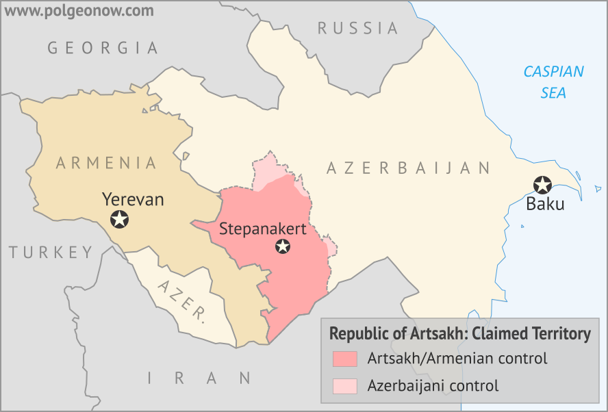
Map of the self declared Republic of Artsakh (Nagorno-Karabakh Republic) in relation to Armenia and Azerbaijan. Includes capital cities Yerevan, Baku, and Stepanakert.
Map by Evan Centanni, modified from this map by Bourrichon and Lesqual. License: CC BY-SA

Nagorno-Karabakh is Now “Artsakh”

Most country name changes are just modifications to the country’s official long name, or a switch in the name’s preferred English translation. But last year, one self-proclaimed country changed its title completely.

In February 2017, the disputed Nagorno-Karabakh Republic officially became the “Republic of Artsakh“. The name switch was part of a new constitution, approved in an internationally-controversial Feb. 20 referendum. According to the breakaway government’s official figures, the referendum passed by 88%, with a voter turnout of 76%.

What is Nagorno-Karabakh/Artsakh?

The status of the so-called Republic of Artsakh is a matter of hot dispute. According to the UN and all its member countries, Nagorno-Karabakh was never officially a country at all. The region is claimed by Azerbaijan and labeled a disputed territory by the international community, but it declared independence during the breakup of the Soviet Union, and has been ruled separately from Azerbaijan since the early 1990s.

In terms of military defense and day-to-day administration, Artsakh is heavily integrated with neighboring Armenia (most people living there are culturally Armenian). But the region’s government officially considers itself an independent country, and Armenia maintains a formal separation, neither recognizing Artsakh’s independence nor making it officially part of Armenia.

The only formal recognition of Artsakh’s independence comes from three other unrecognized, self-proclaimed countries – Abkhazia, South Ossetia, and Transnistria – plus a long list of local governments inside the US who have made symbolic declarations of support (presumably at the urging of that country’s Armenian political lobby).

Nagorno-Karabakh and Artsakh: Both Names Accepted

The name “Republic of Artsakh” didn’t come out of nowhere – in fact, it was already an official alternate name for the claimed country. The new constitution basically just switches the two names’ places:

Before After
Main Name in Constitution Nagorno-Karabakh Republic Republic of Artsakh
Official Alternate Name Artsakh Republic Republic of Nagorno-Karabakh

The old constitution declares that the two names are “the same”, and the new one similarly states that both official titles “are identical”. “Artsakh Republic” is also still in use by some official sources, probably as an alternate English translation. Minor spelling variants seen in government sources include “Nagorno Karabakh” (without the hyphen) and “Nagorno Karabagh”.

What Does “Artsakh” Mean, and Why Choose it Over “Nagorno-Karabakh”?

“Artsakh” is probably easier to remember and pronounce for most people, but the change is also related to the history of the two names. “Nagorno-Karabakh” is actually the Russian name of the region, from when it was part of the Soviet Union, but the “Karabakh” part is based on its name in the Azerbaijani language (likely coming from ancient words meaning “Black Garden“). 

The territory now being disputed is the highland area of the historic Karabakh region, with the Russian word “nagorno” (or “nagorny”) added on signify that. In other words, “Nagorno-Karabakh” means “Upper Karabakh” in Russian.

“Artsakh”, on the other hand, is a thoroughly Armenian name for the territory. Though the actual origin of the word has been lost to history, it was the undisputed name of an Armenian province that occupied the area from ancient times into the Middle Ages. Given that, it’s no surprise that this name is preferred by the Armenia-oriented government of the disputed republic, or by its culturally Armenian majority population.

Flag of the autonomous community of Catalonia Short Name:  
• Artsakh (English, Armenian)
• Dağlıq Qarabağ (Azerbaijani)
Alternate Short Name:
• Nagorno-Karabakh (English)
• Lerrnayin Gharabagh (Armenian)
Full Declared Name:
• Republic of Artsakh (English)
• Artsakhi Hanrapetut’yun (Armenian)
Alternate Full Name:
• Nagorno-Karabakh Republic (English)
• Lernayin Gharabaghi Hanrapetut’yun (Armenian)
Capital: Stepanakert
Status According to Azerbaijan: Armenia-occupied area of Azerbaijan

When Did The Name Change Officially Happen?

When a fully-recognized country, like the Czech Republic, changes its name, it’s fairly simple to the confirm that the change has gone into effect: It soon gets registered in UN databases and the ISO standard list of country codes and names. But for a disputed breakaway region like Artsakh, there’s no such official international documentation.

As with Malawi’s 2012 flag change, we at PolGeoNow were unsure at first if the change had officially come into effect yet – part of the reason we haven’t published an article until now. News outlets reported on Nagorno-Karabakh’s Feb. 20 referendum, but none seemed to say when the change would actually become official (at least, not in English).

So we dug a little deeper, learning that the official law authorizing the referendum says:

[The changes will] enter into force from the moment of publishing the drafts in the “Official Bulletin of the Nagorno Karabakh Republic” within five days after announcing the resolution of the Central Commission or the Supreme Court on the results of the the [sic] Referendum.

We couldn’t find the Official Bulletin in English online, but a declaration on the final referendum results from the Central Electoral Commission is dated to February 23. This seems to suggest that the official name change happened within five days of that, by February 28, 2017. Confirming that the new name has been adopted, the official website of the republic’s president is using “Artsakh”, even though some other government websites haven’t yet changed their headers.

PolGeoNow reports on every country name change that happens in the world! To see the full list, view all country name change articles.

Graphic of the flag of the Republic of Artsakh is in the public domain (source).

Syrian Civil War Map & Timeline: Rebels Lose Major Ground – January 2018 (Subscription)

SUBSCRIBERS CLICK HERE TO PROCEED TO ARTICLE AND MAP

There are newer versions of this map available. To see them, view all Syria updates.

Research by Djordje Djukic. Map by onestopmap.com, Evan Centanni, and Djordje Djukic

Subscribe for full access to all conflict map reports!


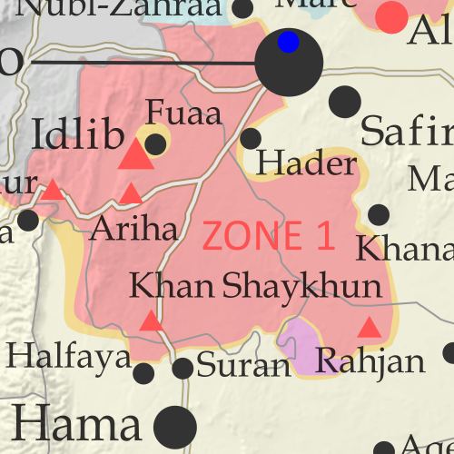
Map of Syrian Civil War (Syria control map): Fighting and territorial control in Syria in January 2018 (Free Syrian Army rebels, Kurdish YPG, Syrian Democratic Forces (SDF), Jabhat Fateh al-Sham / Hayat Tahrir al-Sham (Al-Nusra Front), Islamic State (ISIS/ISIL), and others). Includes Russia-Turkey-Iran agreed de-escalation zones and US deconfliction zone, plus recent locations of conflict and territorial control changes, such as Abu al-Duhur, Beit Jinn, Rahjan, and more. Colorblind accessible.
The past month has seen major losses for hardline rebels in Syria’s northwest, excluded from the de-escalation agreements, even as the push against the so-called “Islamic State” (ISIS/ISIL) has slowed in the east.

See all this and more on the latest update to PolGeoNow’s concise, professional Syrian Civil War control map, which includes a timeline of changes since our previous Syria map report in November, with sources cited.

This map and report are premium content, available to paid subscribers of the PolGeoNow Conflict Mapping Service.

Want to see before you subscribe? Check out our most recent FREE SAMPLE Syria map!

Exclusive map report includes:

  • Up-to-date illustration of current territorial control in Syria, color-coded for the Assad government, rebel groups, “Islamic State” (ISIS/ISIL) fighters, and Kurdish/SDF forces. Colorblind accessible.
  • Markers showing the approximate locations of Russian-Turkish-Iranian “de-escalation zones” and the one known US “deconfliction zone”.
  • Special symbols indicating towns dominated by rebels of the former Al Qaeda Nusra Front (now Hayat Tahrir al-Sham) and US-backed Syrian Democratic Forces (SDF).
  • Detailed indication of city-by-city control, including key towns and other locations important to current events.
  • Locations of recent fighting and other important events, including Abu al-Duhur, Beit Jinn, Rahjan, and more.
  • Detailed timeline of important events and changes to territorial control since December 13, 2017, compiled by our Syria-Iraq expert, with links to sources.

SUBSCRIBERS CLICK HERE TO PROCEED TO ARTICLE AND MAP

Not signed up yet? Click here to learn more about our professional subscription service!

Can I purchase just this map?
This map and report are not available for automated purchase to non-subscribers. If you need access or republication rights for only this map report, contact service@polgeonow.com for options.

How Many Countries Are There in the World in 2018?

This article, originally from 2011, has been revised and updated to January 2018. You can view some older versions of the article in our archives.

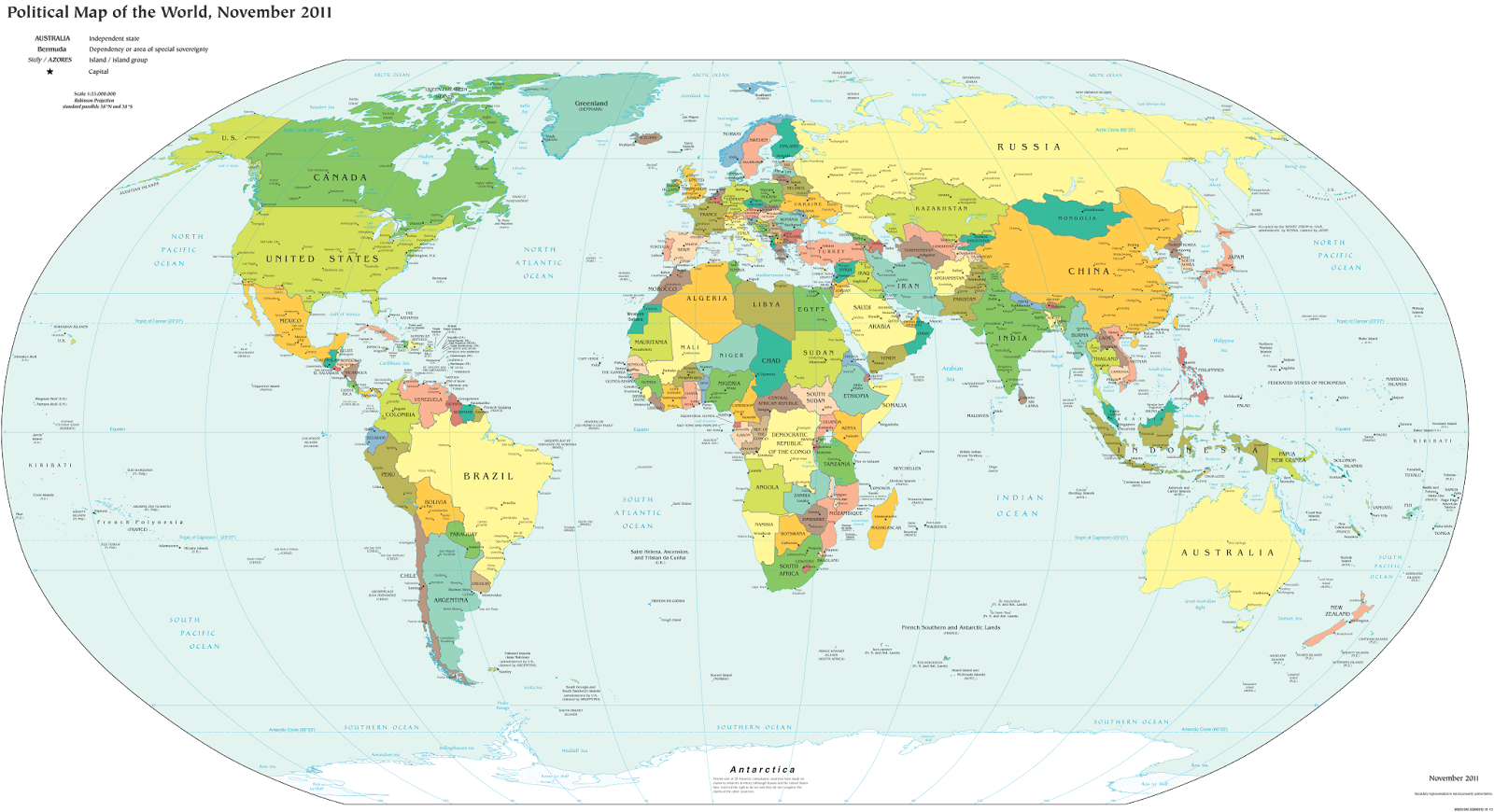
How many countries: map of the world
A world political map published by the US government. South Sudan is the most recent addition to the UN-based list of the world’s countries.

One of the most basic questions for map-lovers is, “How many countries are there in the world?” But anyone who just gives you a number isn’t telling the whole truth. It actually depends a lot on how you define a “country”.

Here are six of the most common answers, each correct in its own way:

195 Sovereign States According to the UN
“Country” and “nation” are casual words for what political scientists call a “sovereign state”, meaning a place with its own borders and completely independent government. The question of which places count as sovereign states can be controversial, but for starters we normally count all the member and observer countries of the United Nations (UN):

UN Members: 193
UN Observer States: 2
Total: 195

These countries mostly all accept each other as sovereign states, and they’re the ones you’ll see on most world maps and lists of the world’s countries. Almost every country you’ve ever heard of is probably a member of the UN, and the two UN Observer States are Vatican City (represented by the Holy See) and Palestine. If you want to know the names of all 195, Wikipedia has a complete list.

The last addition to the list was in 2012, when Palestine became a UN Observer State, and the last time the number of full UN members changed was when South Sudan joined in 2011.

Note: Palestine’s approval as a UN Observer State was controversial, so some lists may still only have 194 countries.

201 States With At Least Partial Recognition
Several more country candidates are left out of the UN itself, but are still officially acknowledged by at least one UN member (this kind of official acceptance is called “diplomatic recognition“). These controversial countries are usually labeled on world maps as disputed territories or special cases, if they’re on the map at all.

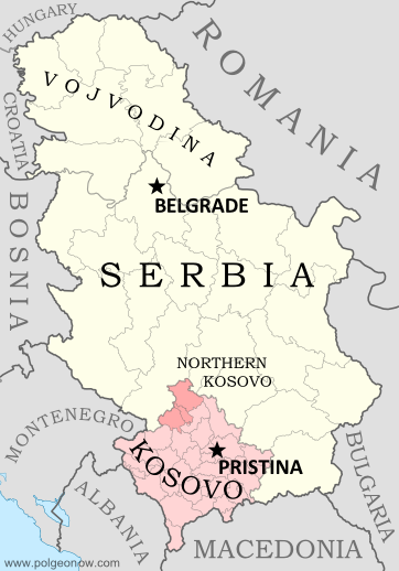
Map of Serbia, Kosovo, and North Kosovo
Kosovo is claimed by Serbia, but recognized as independent by over 100 countries.

UN Members: 193
UN Observer States: 2
States With Partial Recognition:
Total: 201

The six non-UN states with partial recognition are Taiwan, Western Sahara, Kosovo, South Ossetia, Abkhazia, and Northern Cyprus. All of these are claimed as parts of other countries, but aren’t actually controlled by them (at least not completely). The number of UN members recognizing them varies, from just one for Northern Cyprus to over 100 for Kosovo.

A few lists also include the Cook Islands and Niue as partially-recognized states. These two places sometimes act like independent countries, but they’ve never actually declared independence or tried to join the UN. They’re usually considered to be highly self-governing overseas territories of New Zealand.

204-207 De Facto Sovereign States
But wait, there’s more! Those six partially recognized countries aren’t the only breakaway states with full self-governance. There are at least three more self-declared countries that aren’t recognized by any UN members at all, but still operate independently from the countries that claim them. These are often called “de facto” sovereign states, a fancy Latin way of saying they’re independent countries in actual fact, even if not on paper.

UN Members: 193
UN Observer States: 2
States With Partial Recognition:
Unrecognized de facto Sovereign States: 3 to 6 (see below)
Total: 204 to 207

The three places most often considered de facto independent countries are Nagorno-Karabakh, Transnistria, and Somaliland. And since 2014 there have been three more contenders for the list, questionable because they’re located in active war zones and have only limited government structures: The so-called “Islamic State” is almost out of the running now that it’s lost most of its territory in Syria and Iraq, but the Donetsk People’s Republic and the Lugansk People’s Republic, which claim independence from Ukraine, don’t seem to be going anywhere.

Tiny “micronations” declared by individual people usually aren’t taken seriously enough to put on the list. The closest contender would be Sealand, but it’s debatable whether this tiny “nation” really counts as having a territory, population, or government, all key ingredients for a sovereign state.

There are also many rebel-held territories (and fully self-governing areas like Puntland state in Somalia) that aren’t controlled by any country, but are left off the list because they don’t claim to be independent. They agree in principle that they’re part of another country, even though they might disagree about who should be in charge, or how the country should be governed.

206 Olympic Nations
Lots of people learn about the world’s list of countries by watching the Olympic Games every two years. If you’re one of them, you might be confused at why the Olympic Parade of Nations claims over 200 members, even though your atlas only has 195.

This is because the Olympics didn’t always require applicants to be independent countries. Dependent territories with partial self-government have sometimes been approved by the International Olympic Committee (IOC), and a couple of the partially-recognized states mentioned above have also managed it.

Olympic Nations that are UN Member States: 193
Olympic Nations that are UN Observer States: 1
Olympic Nations that are Partially-recognized States: 2
Olympic Nations that are Dependent Territories: 10
Total IOC-Recognized Olympic Nations: 206

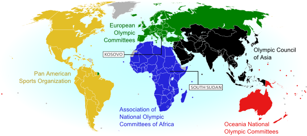
World map showing the five continental associations of National Olympic Committees, including all nations eligible for the Olympic games
The Olympics include most of the world’s independent countries, and some dependent territories too.

About half of the dependent territories in the Olympics are overseas possessions of the US (like Puerto Rico) or the UK (like Bermuda). Some nearly-independent “countries” like the Cook Islands (associated with New Zealand) and Aruba (a “constituent country” of the Netherlands) are included too.

Every UN member country is also in the Olympics, with the latest addition, South Sudan, joining in August 2015.  The one UN Observer State in the Olympics is Palestine; Vatican City apparently isn’t interested. As for the two partially-recognized countries in the games, Kosovo became an Olympic Nation in 2014, and Taiwan has been a member for some time, but has to call itself  “Chinese Taipei” after a deal struck with China in the 1980s.

Learn More: Parade of Nations: Which Countries Are (and Aren’t) in the Olympics

211 FIFA Countries Eligible for the World Cup
Soccer – or “football” as it’s known in many countries – is the world’s most popular sport, and most international matches all the way up to the World Cup are regulated by an organization called FIFA. If you’re a soccer super-fan, you might know that, until recently, there were 209 member countries that compete in FIFA matches (even though most don’t make it to the World Cup). That’s already more than the number of Olympic Nations, and definitely more than the total independent countries on most world maps.

Like the Olympics, FIFA didn’t always require independence or international recognition for its members. Now it’s a bit stricter, but any team that’s already a member is allowed to stay. The two newest members, which joined in May 2016, both made it in under special circumstances: Kosovo, a partially-recognized country, was voted in after being recognized by more than half of the UN’s members; and Gibraltar, an overseas territory of the UK, recently got a court order allowing it in without being independent.

Based on European tradition, FIFA also allows England, Scotland, Wales, and Northern Ireland to compete as separate teams, even though they’re all part of the UK.

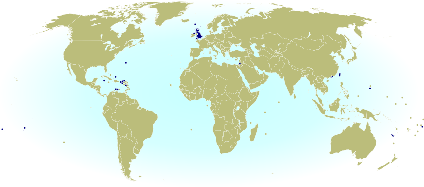
World map marking dependent territories, partially recognized sovereign states, and subnational entities that have national football (soccer) teams recognized by FIFA, making them eligible for the World Cup.
Map from 2014 of FIFA members that aren’t recognized as independent countries by the UN

Teams of UN Member States: 186
Teams of UN Observer States: 1
Teams of Partially Recognized States: 2
Teams of UK Constituent Countries: 4
Teams of Dependent Territories: 18
Total FIFA Member Associations: 211

You might notice that not all of the 193 UN member states are included. That’s because several very small countries aren’t members, plus the UK is replaced by its four “constituent countries”, which aren’t UN members on their own.

Learn More: Which Countries Are (and Aren’t) Part of FIFA? (2014)

249 Country Codes in the ISO Standard List
Ever been filling out an internet form, and had to choose from a surprisingly long list of countries? You were probably looking at the international standard “country code” list, formally known as ISO 3166-1. Lots of companies and other organizations adopt this standard list instead of spending their own time compiling one. The standard also includes convenient two-letter codes for each country, like us for the United States, de for Germany, and jp for Japan, which you might recognize from website addresses specific to those countries.

This ISO standard is based on an official list kept by the UN…but then why on Earth are there 249 country codes? That’s way more than the total number of UN member and observer countries! Well, the standard list does leave out some breakaway states not recognized by the UN, but makes up for it by listing dependent territories separately from their parent countries. In other words, the ISO list is more an answer to the question, “How many countries and territories in the world?” than “How many countries in the world?”

This means there are “country codes” not just for actual countries, but also for nearly-independent states, overseas colonies, uninhabited islands, and even Antarctica! This is important, because organizations might need an option for every place that any person can be located, and dependent territories often aren’t technically part of the countries they belong to.

UN Members: 193
UN Observer States: 2
States With Partial Recognition:
Inhabited Dependent Territories: 45
Uninhabited Territories: 6
Antarctica: 1
Total: 249

So there you have it! Next time someone tells you “There are 194 countries in the world,” remember that the real answer isn’t so simple!

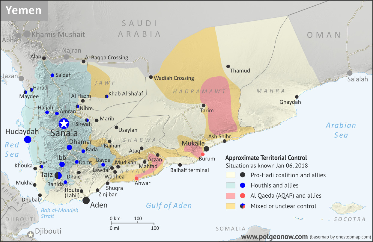
Yemen Control Map & Report – January 2018

There are newer versions of this map available. To see them, view all Yemen articles on PolGeoNow. 

This is the first edition of our newly-redesigned Yemen control map, which has been optimized to match our maps of control in Syria, Iraq, Libya, and Somalia.

Map of what is happening in Yemen as of January 6, 2018, including territorial control for the unrecognized Houthi government and former president Saleh's forces, president-in-exile Hadi and his allies in the Saudi-led coalition and Southern Movement, Al Qaeda in the Arabian Peninsula (AQAP), and the so-called Islamic State (ISIS/ISIL). Includes recent locations of fighting, including Mudiyah, Khoukha, Hays, Khab Al Sha'af, and more. Colorblind accessible.
Map by Evan Centanni and Djordje Djukic, from base map by Koen Adams of onestopmap.com. All rights reserved.

(Subscribers click here to view this article in the member area)

Timeline by Djordje Djukic, with additional reporting by Evan Centanni

Yemen: Who Controls What?
As we enter 2018, Yemen continues to be divided between two rival governments – the Saudi-backed administration of President Abdrabbuh Mansour Hadi, and the allegedly Iran-backed “Houthi” group that controls the capital – even while remote areas remain within the sphere of Al Qaeda in the Arabian Peninsula (AQAP). The so-called “Islamic State” (IS; formerly ISIS/ISIL) is not believed to control any towns, but is probably still present in the rural border areas between Bayda and Abyan provinces, near Lawdar.

Since our previous Yemen map report four months ago, the pro-Hadi coalition has made modest progress against both the Houthis and AQAP, though the Houthis remain firmly entrenched in their core area of control. Meanwhile, the alliance between the Houthi organization and forces loyal to former president Ali Abdullah Saleh disintegrated over the past several months. The conflict between the one-time allies culminated in open battles that brought the southern Sana’a area briefly outside of Houthi military control, ending with the death of Saleh and the rapid defeat of his faction.

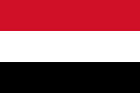
Flag of YemenCountry Name:  
• Yemen (English)
• Al-Yaman (Arabic)
Official Name:  
• Republic of Yemen (English)
al-Jumhūriyyah al-Yamaniyyah (Arabic) 
Capital:  
Sana’a (official)
Aden (seat of internationally-recognized government)

Chronology of Events
The following is a timeline of major events and changes to territorial control since PolGeoNow’s previous Yemen control map report of August 21, 2017.

August 23-24, 2017
A rift emerged in the Houthi-Saleh alliance, with the Houthis accusing their ally Ali Abdullah Saleh, Yemen’s former president, of conducting secret negotiations with the United Arab Emirates (UAE), a member of the Saudi-led coalition supporting the rival Hadi government in Aden.

The Houthis also denounced Saleh’s description of them as a “militia”, the same term Saudi Arabia uses to challenge their legitimacy. Saleh rebuked the Houthi government on television after it called his party traitors, urging them to “hold back your crazy people”, while also appealing for calm among his supporters.

The next day, a pro-Saleh rally was held in the capital, Sana’a.

August 25, 2017
A US military helicopter crashed off the coast of Yemen. All five crewmembers were rescued.

August 26, 2017
Clashes erupted in Sana’a between Houthi and Saleh supporters at a Houthi checkpoint near Saleh’s media office and the home of his son. Two Houthi fighters and a pro-Saleh colonel were killed.

August 28, 2017
Pro-Hadi forces captured a mountain northeast of Sa’dah and west of Al Baqqa border crossing. They had previously seized it early in 2017, but since lost it.

September 1, 2017
Seven pro-Hadi soldiers were killed and 11 wounded when the Houthis shelled their camp in Marib province during Eid prayers.

September 10, 2017
Pro-Hadi sources claimed 145 Houthi fighters had been killed in fighting since the start of the month.

September 11, 2017
A pilot from the UAE died when his plane crashed due to a technical failure. Another Emirati soldier also died of wounds received earlier in the conflict. Over 100 Emirati soldiers had died in the conflict by this point.

September 13, 2017
A Saudi pilot died when his plane crashed due to a technical failure during an operation against Al Qaeda fighters in the Abyan region.

September 14, 2017
Pro-Hadi forces captured the Wadhea district of Abyan from Al Qaeda after pushing the group out from several villages.

September 19, 2017
Pro-Hadi security forces conducted a raid against Al Qaeda in Mudiyah district of Abyan province. Later, it was reported that security forces had managed to capture the district, which had been a stronghold of Al Qaeda in the Arabian Peninsula (AQAP).

September 21, 2017
The Houthis staged a rally in Sana’a for the third anniversary of their takeover of the capital.

September 24, 2017
While speaking at the 72nd United Nations General Assembly in New York, Yemen’s Saudi-backed president, Abdrabbuh Mansour Hadi, stated that a military solution was more likely for Yemen’s civil war than a political one.

September 27, 2017
In a recorded speech broadcast on his TV station, Saleh attacked Saudi Arabia and said he would obstruct the return of Hadi to power, a move the pro-Hadi Gulf News reported was made under pressure from his Houthi allies. Meanwhile, Sudanese Lieutenant General Mohammed Hamdan Hamidati, commander of the Sudanese Army Rapid Support Forces, reported that 412 Sudanese soldiers, including 14 officers, had been killed so far in the conflict in Yemen. The general also stated that the Sudanese military had participated in fighting against the Houthis on 40 different fronts.

October 1, 2017
Houthi forces shot down a US surveillance drone in western Yemen.

October 2, 2017
The death toll from an ongoing cholera outbreak in Yemen reached 2,134.

October 9, 2017
Al Qaeda fighters who had withdrawn from Azzan in August were said to be hiding in an area about 80 kilometers (50 miles) to the west of the town.

October 14, 2017
Aidarus al-Zoubaidi, a former governor of Aden and current leader of the separatist Southern Movement, announced that an independence referendum was to be held for the separation of southern Yemen from the north. Al-Zoubaidi had previously been sacked from his governor position by President Hadi, and in May 2017 subsequently announced the formation of a new council composed of senior tribal, military, and political figures seeking secession for the south. The formation of the council was rejected by Hadi. Yemeni fighters of the Southern Movement have fought alongside pro-Hadi forces against the Houthis through much of the war, and have allegedly received political and financial support from the UAE.

October 16, 2017
About 50 fighters belonging to the so-called “Islamic State” organization (IS; formerly ISIS/ISIL) were killed in US airstrikes on two training camps in Bayda province.

October 17, 2017
Two UAE pilots were killed when their military aircraft crashed 110 kilometers (70 miles) north of Sana’a.

October 29, 2017
Three members of the Iranian Revolutionary Guard Corps (IRGC) were reportedly killed in Yemen while assisting the Houthis.

October 30, 2017
Pro-Hadi forces captured the Al Qaeda stronghold of Mahfad in Abyan province and secured the highway between Aden and Azzan.

October 30 – November 1, 2017
More than 100 fighters on both sides were killed in fighting east of Sana’a, in the Nihm area, during which pro-Hadi forces claimed to have advanced, while the Houthis stated they were holding onto their positions. Additionally, more than 80 fighters on both sides died during clashes in the area of Taiz where, according to pro-Hadi sources, the internationally-backed government regained positions on a mountain that had been taken by the Houthis earlier in the week.

November 1, 2017
A Saudi-led coalition airstrike on a hotel in the north of the country left 29 people dead, including children. Meanwhile, the UN put the total death toll from the Yemen conflict at more than 8,670, of whom 60% were civilians. In addition, another 2,184 people had reportedly died due to the cholera outbreak caused by the war. In contrast, the UN previously estimated in January 2017 that at least 10,000 people had already been killed in the conflict at that point.

November 4, 2017
The Houthis launched a ballistic missile towards the Saudi capital, Riyadh, with the city’s international airport as its main target. The missile was intercepted and destroyed, with debris landing inside the airport.

November 5-6, 2017
Two IS suicide bombers attacked the Hadi government’s security headquarters in Aden, as well as the building hosting the criminal investigations unit, after which other fighters seized the latter building and took hostages. The hostage crisis continued until the following day, with two more suicide bombers triggering their explosives as security forces attempted to retake the building. In the end, 29 members of the security forces and six civilians were left dead.

November 6-11, 2017
The Saudi-led coalition shut down air, land, and sea routes into Yemen following the Houthi ballistic missile attack on Riyadh. Saudi Arabia asserted that blockade was necessary to stop Iran from sending additional weapons to the Houthis. Three days later, a senior UN official warned that Yemen faced the world’s largest famine in decades, “with millions of victims”, if the coalition’s blockade was not lifted. The same day, the coalition opened the Wadiah border crossing with Yemen, partly easing the blockade (the Hadi-administered port of Aden had also been re-opened the previous day). On November 11, the coalition announced it would allow the resumption of international commercial flights to Yemen.

November 7, 2017
Coalition airstrikes against a village in the northwestern province of Hajjah left 50 people dead, including civilians. Meanwhile, pro-Hadi forces reportedly captured four positions in the province of Taiz.

November 12, 2017
Pro-Hadi forces reportedly seized several positions southeast of Taiz from the Houthis, as well as others northwest of Houta.

November 14, 2017
An IS suicide bomber attacked a security post in Aden, killing eight security forces members and two civilians.

November 13-17, 2017
The Saudi-led coalition won control of an airport in eastern Yemen’s Mahra province through negotiations with local authorities, after initially being rebuffed by a Yemeni army brigade stationed there. The coalition is reportedly in control of Ghaydah town, while local authorities still control several ports in the province.
November 22, 2018
The Saudi-led coalition announced that it would further ease the blockade by allowing aid shipments to enter via the Houthi-held Hudaydah port and Sana’a airport. 

November 29 – December 3, 2017
Houthi and pro-Saleh forces clashed with each other in the capital city of Sana’a, with pro-Saleh fighters securing the southern part of the city, specifically the Hadda district. The city’s northern part remained under Houthi control. Saleh then declared that a “new page” would be turned with the Saudi-led coalition if it stopped its attacks on Yemen and lifted the blockade of the country. The Houthis called Saleh’s overture to the Saudis “a coup”, while the coalition praised him. The Guardian described the fighting as the disintegration of the Houthi-Saleh alliance.

On December 3, the Saudi-led coalition conducted airstrikes in Sana’a in support of Saleh loyalists. Meanwhile, an airstrike in the province of Sa’dah left 12 civilians dead. At this point, the Houthis claimed to have secured control over most of Sana’a, something that Saleh loyalists denied. The Houthis also said they had seized the city of Dhamar south of Sana’a from pro-Saleh forces.

December 4, 2017
Former president Ali Abdullah Saleh was killed, along with the assistant secretary-general of his party, Yasser al-Awadi. They died in an RPG and gun attack by Houthi fighters on their armored vehicle. According to one report, they were killed outside Sana’a, while another report said they died in the eastern province of Marib while Saleh was attempting to flee to Saudi Arabia.

December 5, 2017
Following the death of Saleh, the Houthis moved to tighten their grip on Sana’a, setting up new checkpoints and reportedly arresting Saleh supporters. Overall, it was reported that the pro-Saleh uprising in the capital had been crushed. By this point, the death toll from the fighting in Sana’a had reached 234. Also among the dead was General Tareq Mohammed Abdullah Saleh, Saleh’s nephew and commander of the Saleh loyalists. He reportedly had died in the same attack that killed Saleh.

December 7, 2017
Pro-Hadi forces captured the Khoukha district, site of a small port south of Hudaydah.

December 9-10, 2017
Pro-Hadi forces captured the Hays district, just inland from Khoukha, after which they entered a third district of Hudaydah province and reportedly seized it the following day. However, it was reported on the same day that the Houthis had cut off the road between Mukha (Mocha) and Khoukha, forcing pro-Hadi troops to retreat from Hays.

December 15, 2017
Pro-Hadi forces captured the Usaylan district of Shabwa province, on the eastern front with the Houthis, after which fighting moved to the outskirts of Baihan. Later, some pro-Hadi sources claimed their forces captured the Baihan district, while others reported they had seized several areas but that the district was still contested. It was subsequently confirmed that the town of Baihan had been captured by pro-Hadi forces.

December 20, 2017
For a second time, the Houthis launched a ballistic missile towards the Saudi capital Riyadh, with the main target being the royal Yamama Palace. The missile was intercepted and destroyed.

December 25, 2017
Pro-Hadi forces reportedly pushed into Bayda province and claimed to have captured two districts there.

December 28, 2017
A top UN official reported that the Saudi-led coalition had killed 109 civilians in airstrikes over the previous ten days, including 54 at a market and 14 members of one family. The coalition denied this, asserting that the official’s information was not credible, and accusing him of siding with the Houthis.

December 31, 2017
Pro-Hadi troops reportedly captured most of the Khab Al Sha’af district, the largest in Jawf province. Meanwhile, fighting was ongoing in the two districts of Bayda province that pro-Hadi forces had earlier claimed to have seized.

January 3, 2018
Fighting took place in the agricultural areas of Hays at the town’s entrances. Meanwhile, a Houthi attack on pro-Hadi positions in the coastal areas of Hudaydah was repelled.

January 5, 2018
The chief of staff of Yemen’s pro-Hadi army was injured in a land mine explosion in the Khab Al Sha’af area of Jawf province, while state-run media claimed that government fighters with Saudi air support had captured a mountain north of Al Hazm. The same day, Houthi forces fired another ballistic missile, this time at a military camp on the Saudi side of the border in the city of Najran. Houthi media claimed the missile hit its target, while Saudi Arabia claimed to have intercepted the missile in mid-air.

What happens next? Check for updates to this map by viewing all Yemen reports on PolGeoNow!

[Editor’s note: The timeline entry for November 13-17, 2017 was added on January 8, 2018.]

Graphic of the Yemeni flag is in the public domain (source).

Mauritania Flies a New Flag

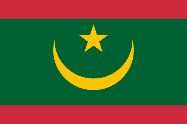
Mauritania Flag: 2017 new flag design after referendum, featuring red bands
Current flag of Mauritania (2017)

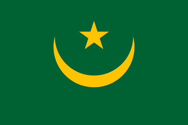
Mauritania Flag: Colors before 2017 referendum that added red bands
Previous flag of Mauritania (1959-2017)

Mauritania’s 2017 Flag Change

This year the West African country of Mauritania (pronounced “maur-ih-TAY-nee-ah”) became the latest of the world’s countries to change its flag, mostly keeping the old design but adding red bars on the top and bottom.

It’s common around the world for even a small flag change to be criticized as a political distraction or a waste of money, and this was no exception. But when it landed on ballots in an August 5 referendum this summer, the modification was approved by 86% of participating voters.

The new flag was first officially raised on November 28, Mauritania’s independence day.

What Does Mauritania’s Flag Mean?

Until this year, Mauritania was one of only a few world countries whose flag didn’t include the colors red, white, or blue. The star and crescent moon, originally an emblem of the Ottoman Empire, are now used in many national flags as symbol of the Muslim world.

The color green is also a symbol of Islam, while the golden yellow of the star and crescent are said to represent the sands of the Sahara Desert. The new red bars symbolize blood sacrificed to defend the national territory in both the past and in the future.

Country Name:  
• Mauritania (English)
• Mūrītānyā (Arabic)
Moritani (Pulaar)
Murutaane (Soninke)
Murutaane (Wolof)
• Mauritanie (French)
Official Name:  
• Islamic Republic of Mauritania (English)
• al-Jumhūrīyah al-Islāmīyah al-Mūrītānīyah (Arabic)
• Republik bu Lislaamu bu Gànnaar (Wolof)
• République islamique de Mauritanie (French) 
Capital: Nouakchott

Green and red are also part of the Pan-Arab colors used in flags across the Arab World, while red, green, and gold are one version of the Pan-African colors.

How Often Do Countries Change Their Flags?

There were almost 70 national flag changes in the 1990s, during the late stages of decolonization and the end of the Cold War, but since then the rate has slowed. From 2000 through 2009, there were about 25 flag changes, and since the beginning of 2010 there have been about 12.

That’s still an average of almost two changes annually, but the past four years have seen a bit of a dry spell: Before Mauritania, the most recent countries to change their flags were Paraguay and Afghanistan in 2013, preceded by Malawi and Belarus in 2012 and Libya in 2011.

For more news about past and future flag modifications, you view all flag change articles on PolGeoNow!

Graphic of current Mauritanian flag licensed under CC BY-SA (source). Graphic of the previous Mauritanian flag is in the public domain (source).

Syrian Civil War Map & Timeline: “Islamic State” Territory in Pieces – December 2017 (Subscription)

SUBSCRIBERS CLICK HERE TO PROCEED TO ARTICLE AND MAP

There are newer versions of this map available. To see them, view all Syria updates.

Research by Djordje Djukic. Map by onestopmap.com, Evan Centanni, and Djordje Djukic

Subscribe for full access to all conflict map reports!


Map of Syrian Civil War (Syria control map): Fighting and territorial control in Syria in December 2017 (Free Syrian Army rebels, Kurdish YPG, Syrian Democratic Forces (SDF), Jabhat Fateh al-Sham / Hayat Tahrir al-Sham (Al-Nusra Front), Islamic State (ISIS/ISIL), and others). Includes Russia-Turkey-Iran agreed de-escalation zones and US deconfliction zone, plus recent locations of conflict and territorial control changes, such as Abu Kamal, Quriyah, Rahjan, and more. Colorblind accessible.
As opposing forces close in, the so-called “Islamic State” (ISIS/ISIL) has seen its Syrian territory divided into seven different pieces, and you might be surprised where some of them are located. Meanwhile, fighting between the government and rebels continues at a low level.

See all this and more on the latest update to PolGeoNow’s concise, professional Syrian Civil War control map, which includes a timeline of changes since our previous Syria map report in November, with sources cited.

This map and report are premium content, available to paid subscribers of the PolGeoNow Conflict Mapping Service.

Want to see before you subscribe? Check out our most recent FREE SAMPLE Syria map!

Exclusive map report includes:

  • Up-to-date illustration of current territorial control in Syria, color-coded for the Assad government, rebel groups, “Islamic State” (ISIS/ISIL) fighters, and Kurdish/SDF forces. Colorblind accessible.
  • Markers showing the approximate locations of Russian-Turkish-Iranian “de-escalation zones” and the one known US “deconfliction zone”.
  • Special symbols indicating towns dominated by rebels of the former Al Qaeda Nusra Front (now Hayat Tahrir al-Sham) and US-backed Syrian Democratic Forces (SDF).
  • Detailed indication of city-by-city control, including key towns and other locations important to current events.
  • Locations of recent fighting and other important events, including Abu Kamal (Al Bukamal), Quriyah, Rahjan and more.
  • Detailed timeline of important events and changes to territorial control since November 14, 2017, compiled by our Syria-Iraq expert, with links to sources.

SUBSCRIBERS CLICK HERE TO PROCEED TO ARTICLE AND MAP

Not signed up yet? Click here to learn more about our professional subscription service!

Can I purchase just this map?
This map and report are not available for automated purchase to non-subscribers. If you need access or republication rights for only this map report, contact service@polgeonow.com for options.

Explainer: Is Jerusalem the Capital of Israel or Not?

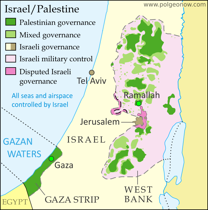
Detailed map of administrative control in Israel and the Palestinian territories (West Bank and Gaza Strip), including official and de facto capitals. Cities: Jerusalem, Ramallah, Gaza, Tel Aviv. Colorblind accessible.
Map by Evan Centanni. All rights reserved.

US recognizes Jerusalem as capital of Israel

This Wednesday, the United States government announced a new policy of recognizing Jerusalem as the capital of Israel. US president Donald Trump said the declaration’s purpose was to “acknowledge the obvious”, while also revealing plans to eventually move the US embassy in Israel to Jerusalem. These decisions were extremely controversial, to say the least. But why? We’ll break it down for you:

So, what’s the big deal?

Israeli law says the city of Jerusalem is the country’s capital. But even Israel’s closest ally, the US, has never officially accepted  the city’s capital status. Almost every other country in the world has done the same: In fact, no country in the world has a proper embassy in Jerusalem. So the new move by the US is a major change of policy, and one that runs contrary to an established world consensus.

But is Jerusalem not the capital of Israel?

A country’s capital is usually, but not always, defined as the city where its government is headquartered. And it’s true that Jerusalem is both the official capital of Israel under the country’s laws, plus the seat of the country’s government, including the legislature, the prime minister, and the Supreme Court. So in that sense Jerusalem is indeed the capital of Israel, for practical purposes at the very least. But that doesn’t mean other countries consider its status legally valid…

So why not recognize Jerusalem as Israel’s capital?

Territory Name:  
• Jerusalem (English)
Yerushalayim (Hebrew)
al-Quds (Arabic)
Claimants: 
• Israel
• Palestine (east Jerusalem only)
Actual Control: Israel
Status: 
• Municipality in Israel (actual governance)
Sub-district in Palestine (claimed; east Jerusalem only)
Part of Jerusalem corpus separatum (claimed by much of international community)

It’s rare for countries to dispute the status of each other’s capitals. The sticking point here is that Arab people in the neighboring West Bank and Gaza Strip territories also claim Jerusalem as the capital of their self-declared State of Palestine.

Just making a competing claim isn’t enough to inspire a worldwide boycott. But the thing is, the United Nations (UN) plan that first endorsed an independent Israel also said Jerusalem should be neutral ground between the Jewish country (now called Israel) and an Arab country (now called Palestine, though “Palestine” was originally a culturally-neutral name for the whole area).

The idea was that Jerusalem and the surrounding area, including the Christian holy city of Bethlehem, would be an internationally-governed neutral zone known as a “corpus separatum” (Latin for “separated body”). But Israel’s 1948-1949 war of independence left western Jerusalem under Israeli control, and since the Six-Day War of 1967, Israel has controlled the whole area. Many think the neutral Jerusalem plan is as good as dead now, but many countries still support it in principile, even treating it as the official legal situation for diplomatic purposes.

Even if they do think neutral Jerusalem is a pipe dream, most countries still support a future where Arabs will get their independent Palestine alongside Israel, and that usually means Jerusalem would at least get divided up between the two countries. In fact, US president Trump made a point of acknowledging that possibility even as he controversially recognized the city as Israel’s capital.

Flag of Israel Country Name:  
• Israel (English)
Yisra’el (Hebrew)
ʼIsrāʼīl (Arabic)
Full Declared Name:  
• State of Israel (English) 
• Medinat Yisra’el (Hebrew)
Dawlat ʼIsrāʼīl (Arabic)
Capital: 
• Jerusalem (functioning but disputed)

Which other countries recognize Jerusalem as Israel’s capital?

It’s difficult to make a full list of countries that recognize Jerusalem’s capital status, because there’s no official register for them to record their positions in. Instead, we’re stuck with looking at what their governments say, and trying to figure out what exactly they mean. 

Maybe the only two countries that seem to unconditionally accept Jerusalem’s role as Israel’s capital are Vanuatu, which reportedly recognized it earlier this year, and disputed Taiwan, which isn’t even recognized as a country itself by most of the world. The Philippines has suggested it might move its embassy to Jerusalem, but doesn’t seem to have made a formal statement of recognition.

Czechia (the Czech Republic) declared the day after Trump’s speech that it recognizes West Jerusalem, but not the whole city, as the capital of Israel. Similarly, Russia’s government has said it thinks East Jerusalem should become Palestine’s capital, and “in this context we view West Jerusalem as the capital of Israel”. This was reported in some media as a recognition, but Russia’s government declared that this week’s US announcement “defies common sense“, so it seems unlikely that’s what they meant.

Other countries have kept their statements vague or neutral, neither recognizing nor rejecting Jerusalem’s claimed capital status.

Then where are all these countries’ embassies, if they’re not in Jerusalem?

Most countries, formerly including the US, don’t recognize any particular city as being the capital of Israel. But all of their embassies are located in the city of Tel Aviv or its suburbs. In the early 1970s, there were 16 countries that did have their embassies in Jerusalem, but most of them left in 1980 after Israel claimed the city’s disputed eastern half as part of its capital. By 2006, there were no more left. 

Even the US embassy is still in Tel Aviv for now, but President Trump says he plans to move it to Jerusalem eventually, maybe after another six months. If he does, it could be the first international embassy to return to Jerusalem, though several more countries might jump on the bandwagon.

Flag of Palestine Claimed Country Name:  
• Palestine (English)
Filasṭīn (Arabic)
Full Declared Name:  
• State of Palestine (English)
• Dawlat Filasṭin (Arabic)
Capital: 
• Jerusalem (claimed; not controlled)
Ramallah (administrative; Fatah faction)
• Gaza City (administrative; Hamas faction)

Most countries’ representative offices to Palestine, on the other hand, are located near the Palestinian government headquarters in the West Bank city of Ramallah, or else in the coastal town of Gaza (ruled by a separate faction of the Palestinian government). In general, these offices aren’t called “embassies” – either because the countries don’t fully recognize Palestine as a country, or because they do recognize it but think the real embassies should be in Jerusalem.

But I thought some countries do have offices in Jerusalem

Yes, they do – ten countries, including the US, have “consulates-general” in Jerusalem. Usually a consulate-general is a regional office that serves under a national embassy, but these are special ones. The consulates-general in Jerusalem are officially representatives to the neutral “corpus separatum” area, not representatives to Israel. 

Because of that, they actually don’t answer to their countries’ embassies in Tel Aviv, instead reporting directly to their national governments. Despite their officially neutral status, most of them also serve as their countries’ representative offices to the Palestinian government in the West Bank.

At least Israel and the Jewish people must be happy about this, right?

Yes and no. Israel’s conservative government enthusiastically supported the US recognition of Jerusalem as its capital, and many Israelis are celebrating. But some think it would have been better to wait until the Israeli-Palestinian conflict is resolved, and others don’t think it should be a big deal. Some of the biggest Jewish groups in the US also approved of the decision, but a big portion also disapproved. Many Palestinians, including Arab Christians, were furious with the symbolic gesture. This may or may not include Arab citizens of Israel, most of whom consider themselves Israelis but disagree with aspects of the country’s governance.

Iraq Control Map & Timeline: “Islamic State” Loses Last Towns – November 2017 (Subscription)

SUBSCRIBERS CLICK HERE TO PROCEED TO ARTICLE AND MAP

There are newer versions of this map available. To see them, view all Iraq updates.

Research by Djordje Djukic. Map by onestopmap.com, Evan Centanni, and Djordje Djukic

Subscribe for full access to all conflict map reports!


Detailed map of territorial control in Iraq as of November 29, 2017 after the recapture of Rawa, Qaim and government seizure of additional Kurdish-held territories. Shows territory held by the so-called Islamic State (ISIS, ISIL), the Baghdad government, the Kurdistan Peshmerga, and the Yezidi Sinjar Alliance (YBS and YJE). Colorblind accessible.
Since mid-October, government forces have recaptured the last towns in Iraq controlled by the so-called “Islamic State” (ISIS/ISIL), even while taking more territory from the Kurdistan Region in the wake of its controversial independence vote.

See all this and more on the latest update to PolGeoNow’s concise, professional map of control in Iraq’s civil war, including a timeline of changes since our previous Iraq map report of October 2017.

This map and report are premium content, available to paid subscribers of the PolGeoNow Conflict Mapping Service.

Want to see before you subscribe? Check out our most recent FREE SAMPLE Iraq map report!

Exclusive report includes:

  • Up-to-date map of current territorial control in Iraq, color-coded for the Iraqi government, “Islamic State” (ISIS/ISIL) fighters, Kurdistan’s Peshmerga forces, and Yezidi militias. Colorblind accessible.
  • Detailed indication of town-by-town control, including all major cities and many smaller ones, as well as terrain, major roads, and provincial boundaries
  • Timeline of changes to the situation since mid-October, compiled by our Iraq-Syria specialist, with links to sources

SUBSCRIBERS CLICK HERE TO PROCEED TO ARTICLE AND MAP

Not signed up yet? Click here to learn more about our professional subscription service!

Can I purchase just this map?
This map and report are not available for automated purchase to non-subscribers. If you need access or republication rights for only this map report, contact service@polgeonow.com for options.

Philippines: No More “Islamic State” Control in Marawi

Article by Evan Centanni

(Subscribers click here to view this article in the members area.)

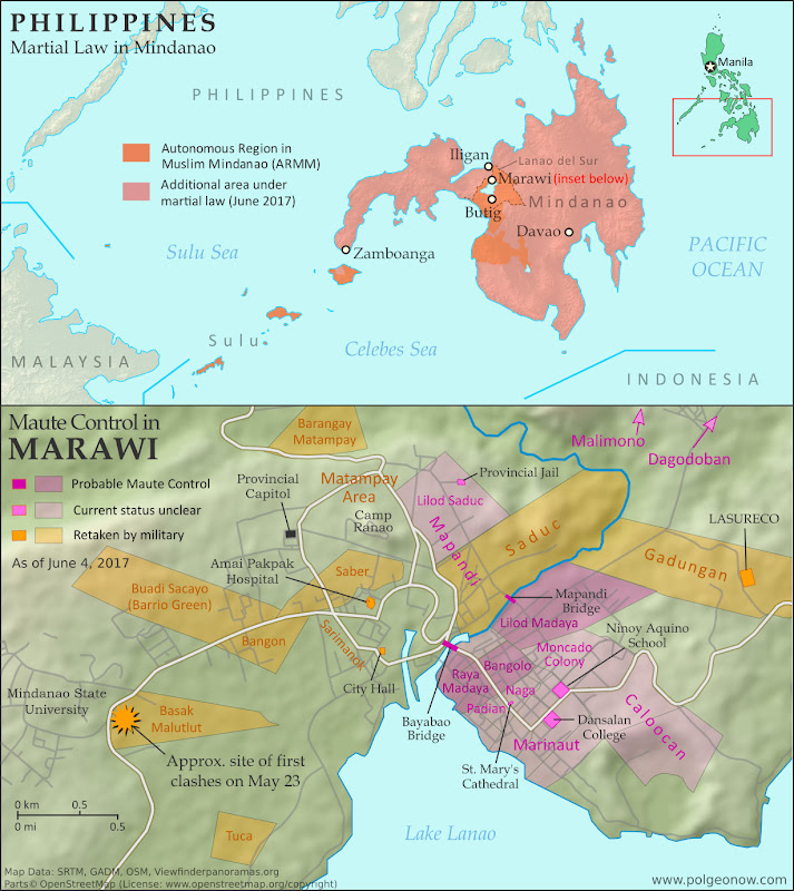
Map of so-called Islamic State (ISIS/ISIL) control in the Philippines, during the May-June 2017 crisis involving the Maute group and Abu Sayyaf takeover of Marawi Ciy, Lanao del Sur province, Mindanao. Updated to June 4, 2017, shows detailed control of Marawi by barangay. Includes map of area affected by martial law declared by President Rodrigo Duterte. Colorblind accessible.

Rebel Takeover in Southern Philippines

In early June, we published a detailed map and timeline of control in the Filipino city of Marawi, which had been partly captured by rebel fighters claiming to representing the so-called “Islamic State” (IS; formerly ISIS/ISIL). In a matter of hours, hundreds of religious hardline fighters had launched a surprise takeover of the city, led by the recently-formed Maute rebel group and Isnilon Hapilon, a leader of the radical Abu Sayyaf network and the IS’s officially designated leader for the Philippines.

The Filipino military quickly moved in to expel the fighters from Marawi, but the battle would drag on for another 5 months before the city was restored to full government control. As part of the government response, President Rodrigo Duterte declared martial law across the entire southern Philippines. For more on the history of martial law in the Philippines, and rebellions in the country’s south, see our article from June.

IS-affiliated Rebels Expelled from Marawi

The siege of Marawi City finally came to an end on October 23, exactly five months after it started, with the capture of the last rebel-held building by the Armed Forces of the Philippines. Over a thousand people had been killed in the fighting, including 165 military and police personnel, over 900 rebel fighters, and dozens of civilians. The three leaders of the insurrection, Hapilon and the two Maute brothers, were among the dead.

Flag of the PhilippinesCountry Name:  
• Philippines (English)
• Pilipinas (Filipino)
Official Name:  
• Republic of the Philippines (English)
• Republika ng Pilipinas (Filipino)
Capital: Manila

President Duterte’s martial law declaration remained in effect, having been extended by the legislature until the end of 2017. As of November, it was not yet clear whether the declaration would be extended again. The military hopes to continue its momentum in batting down other hardline rebel groups in the southern Philippines, such as the Bangsamoro Islamic Freedom Fighters (BIFF).

However, the region’s most prominent rebel force, the Moro Islamic Liberation Front (MILF), reportedly fought alongside government troops against the IS-inspired fighters. The MILF and the Filipino government had already been partway through implementing a drawn-out peace deal at the time the violence erupted in Marawi.

For a timeline of events in Marawi since our June 4 report, see Wikipedia’s well-sourced Battle of Marawi article (sources can be verified using the footnote citations for each timeline entry).

Want to know more? Read PolGeoNow’s in-depth June 2017 article on the rebel takeover of Marawi!

Graphic of the flag of the Philippines is in the public domain (source).