Venezuela Joins Mercosur, Paraguay Suspended

Map of intergovernmental organizations in South America: Mercosur, the Andean Community, and UNASUR (Venezuela and Paraguy indicated)
South America’s intergovernmental organizations: Mercosur in green, the Andean Community (CAN) in (orange), and remaining members of UNASUR in blue (claimed territorial extents). Map by Evan Centanni, based on this map by Wikimedia user Luan.

After over six years of waiting, Venezuela today officially joined Mercosur (the “Southern Common Market”), one of South America’s two main trade blocs.

The country was previously part of the continent’s other major bloc, the Andean Community (CAN), but left that organization last year in anticipation of the switch to Mercosur (see Venezuela Leaves Andean Community).

By the time the Venezuela left CAN last year, its application had finally been approved by all Mercosur member states except for Paraguay; but despite support from that country’s president, an opposition party in its congress continued to block Venezuela’s entry into the trade organization.

That all changed last month, when Paraguay’s government was overthrown in a political spectacle that many denounced as a thinly veiled coup. The country’s membership in Mercosur was suspended as a result, and the rest of the organization quickly took advantage of Paraguay’s absence to vote Venezuela into the group. Full membership for the newcomer was scheduled to enter effect on July 31, 2012.

Flag of VenezuelaCountry Name:  
• Venezuela (English, Spanish)
Official Name:  
• Bolivarian Republic of Venezuela (English)
• República Bolivariana de Venezuela (Spanish)
Capital: Caracas

Mercosur was founded in 1994 by Argentina, Brazil, Paraguay, and Uruguay, with Venezuela today becoming the first new full member (several other South American countries are “associate members” or observers). Integration within the bloc includes a customs union (free movement of goods across borders) as well as economic and judicial coordination between member states.

The countries of both Mercosur and the Andean Community also belong to the Union of South American Nations (UNASUR), a broader organization that includes all of the continent’s sovereign states. Mercosur and UNASUR are the abbreviations based on the groups’ Spanish names, but they are also known by their Portuguese abbreviations, Mercosul and UNASUL.

Graphic of Venezuelan flag is in the public domain (source).

London 2012: Which Countries Are (and Aren’t) in the Olympics?

This is an older version of our Parade of Nations article. Click here to see the newest edition!

The 2012 Summer Olympics in London begin tomorrow (July 27), and it wouldn’t be an Olympic opening ceremony without the Parade of Nations. But how many countries are there in the games, and is everyone included? Read on for an exclusive guide to the roster of Olympic Nations….

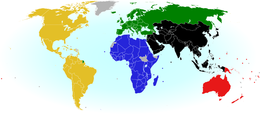
World map showing the five continental associations of National Olympic Committees, including all nations eligible for the Olympic games
The five continental associations representing the world’s Olympic Nations. Gold: Pan-American Sports Organization; Green: European Olympic Committees; Black: Olympic Council of Asia; Red: Oceania National Olympic Committees; Blue: Association of National Olympic Committees of Africa; Gray: non-member country or territory. Map by Evan Centanni, modified from public domain wiki map (source), and modeled after this Wikipedia map.


How many countries participate in the Olympics?
There are currently 204 recognized Olympic Nations, represented by a National Olympic Committee (NOC) in each country. The games are presided over by the International Olympic Committee (IOC), and the NOCs are divided among five continental associations (see map above). [1]

If 204 countries sounds like too many, don’t worry, you’re not going crazy. Indeed, the U.N. only recognizes 194 sovereign states in the world (see also: How Many Countries Are There in the World?). So what gives? Well, it turns out that the IOC has historically been more lax than the U.N. about the criteria for nationhood. Before 1995, some dependent territories were allowed to qualify for the Olympics, and were allowed to stay even after the rules changed. Today, there are ten such territories with Olympic Nation status:

World map marking dependent territories and partially recognized sovereign states which have recognized National Olympic Committees and are allowed by the IOC to participate in the Olympic Games
Click to enlarge: Dependent territories and partially recognized sovereign states admitted to the Olympics. By Evan Centanni, from public domain base map (source).

Americas
 Aruba (Netherlands)
 Bermuda (U.K.)
 British Virgin Islands (U.K.)
 Cayman Islands (U.K.)
 Puerto Rico (U.S.)
 Virgin Islands (U.S.)

Asia
 Hong Kong (China)

Oceania
 American Samoa (U.S.)
 Guam (U.S.)
 Cook Islands (New Zealand)

Besides those exceptions, qualifying as a nation usually requires recognition as a sovereign state by the U.N. However, in 1995 disputed Palestine was admitted for the sake of athletes in Gaza and the West Bank, the two semi-autonomous Palestinian Territories which are largely cut off from the main territory of Israel. And Taiwan, which is claimed by China but effectively ruled as an independent country by the pre-Communist Republic of China government, has also been allowed to participate – but only as long as it refers to itself as “Chinese Taipei”. [2]

Changes to the roster
In the last Summer Olympics in Beijing (2008), there were three new Olympic Nations: the Marshall Islands, Montenegro, and Tuvalu. But since then, no new countries have joined. In fact, one has been removed: the Netherlands Antilles, a Dutch dependency in the Caribbean, was ruled ineligible by the IOC last year after the territory was officially dissolved.

Map marking the location of the former Netherlands Antilles, just prior to the dissolution of the territory
Location of the former Netherlands Antilles. Public domain map (source).

Two of the five islands of the Netherlands Antilles are now separate Dutch territories, and the other three islands have joined the Netherlands proper. Since the IOC no longer admits dependent territories, none of the islands can rejoin under their new administrations, but the former territory’s team of three athletes will be allowed to participate independently under the Olympic flag for now. After 2012, they will need to qualify for the Netherlands team in order to join future games.

Which countries aren’t included in the Olympics?
Despite the inclusive and worldwide mission of the Olympic Games, not all of the world’s states are represented. In fact, two U.N.-recognized countries still haven’t joined: newly independent South Sudan has not yet formed an NOC, though one of its athletes has been accepted to compete under the Olympic flag this time; and U.N. observer state Vatican City, which perhaps doesn’t consider itself a “nation” (since it serves only as the headquarters of the Catholic Church), has never applied.

The ten dependent territories allowed to participate in the Olympics are only a select few, leaving most of the world’s overseas dependencies without their own teams (though athletes from the territories may attempt to qualify for their patron country’s team). And partially recognized or unrecognized states are not usually admitted, even if they are effectively independent. In fact, there are a number of National Olympic Committees which have been created locally but not recognized by the IOC:

World map marking sovereign states and dependent territories which do not have IOC-recognized National Olympic Committees, and are thus not allowed to send their own teams to the Olympics
Click to enlarge: Territories and sovereign states not represented in the Olympics. Light Blue: No NOC; Dark Blue: NOC not recognized by IOC. Also shown in dark blue outlines: subnational regions with unrecognized NOCs. By Evan Centanni, from public domain map (source).

Africa
 Somaliland (unrecognized sovereign state)

Americas
 Anguilla (U.K. territory)
 Montserrat (U.K. territory)
 Turks & Caicos (U.K. territory)

Asia
 Iraqi Kurdistan (autonomous region in Iraq)
 Macau (Special Administrative Region of China) [3]

Europe
 Abkhazia (partially recognized sovereign state)
 Catalonia (region of Spain)
 Gibraltar (U.K. territory)
 Kosovo (partially recognized sovereign state)
 Northern Cyprus (partially recognized sovereign state)

Oceania
 French Polynesia (French territory)
 New Caledonia (French territory)
 Niue (free associate state of New Zealand)
 Northern Mariana Islands (U.S. territory)

Which countries are attending the London 2012 Olympics?
It’s not uncommon for a few countries to miss the Olympic Games in a given year – a small country fails to field a team, a big country boycotts, or tropical countries skip the Winter Olympics – but the London 2012 games are special. This year, all 204 recognized Olympic Nations will be attending the games, resulting in one of the biggest international sports events in history. Wikipedia has a full list of the participating nations, complete with links to the rosters for each national team.

Number of athletes sent to the London 2012 Olympics by each participating country. Map by Foreston/Wikipedia (source). License: CC BY-SA

Now that you know the background on the Parade of Nations, you can watch the London 2012 opening ceremony and games with a new understanding of the political geography behind the sporting event – if you have any questions, post a comment or shoot me an e-mail!

Further info: 2012 Parade of Nations – ordered list of countries and flagbearers (Wikipedia)

Footnotes

[1] The five associations correspond closely to conventional definitions of the continents, but with a few quirks: Turkey, the Caucasus, and Israel are part of the European association despite being geographically in Asia; and the South American territory of French Guiana also falls under European jurisdiction, because it is considered an integral part of France and does not have a separate team.

[2] “Chinese Taipei” is intended to be ambiguous, since most Taiwanese people consider themselves to be at least culturally Chinese. However, the use of “Taipei” is somewhat unfortunate for the two-thirds of Taiwan’s people who do not live in or near Taipei City. This was especially awkward when the 2009 World Games (an Olympics-related event) were held in Kaohsiung, Taiwan – something of a rival city to Taipei. 

[3] Although Macau’s NOC is not recognized by the IOC itself, it has in fact been accepted as a member of the relevant continental organization, the Olympic Council of Asia. Macau has participated in the Paralympic Games but not in the regular Olympics.

Syrian Uprising: Map Update 5

There are newer versions of this map available. To see them, view all Syria updates.

Political Geography Now presents an updated map of territorial division in Syria, where escalating violence is now referred to by the U.N. as a full-scale civil war. Read on for a rundown of recent events.

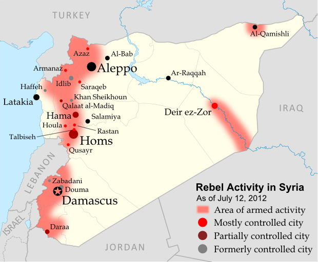
Map of rebel control in Syria's Civil War, updated for July 2012
Activity by rebel groups in Syria, marking areas of armed conflict as well as towns and cities held. Map by Evan Centanni, starting from this blank map by German Wikipedia user NordNordWest. License: CC BY-SA

Syrian Civil War

In the month since our previous Syria report, the Free Syrian Army (FSA), Syria’s main rebel group, has officially abandoned its failed ceasefire with government forces. This nominal change of stance has been presented as a response to continued massacres of Syrian civilians, for which government-supported militias are apparently to blame. Though even the FSA is only a loose organization of rebel cells, other groups have also joined the growing conflict, which the U.N. has begun calling a “civil war“.

Flag of Syria under the current governmentCountry Name:  
• Syria (English)
• Sūriyya/Sūryā (Arabic)
Official Name:  
• Syrian Arab Republic (English)
• al-Jumhūriyyah al-‘Arabīyah  as-Sūriyyah (Arabic)
Capital: Damascus

Rebels Show Strength in North
In the northwest of the country, rebels continue to control much of rural Idlib province, recently capturing the town of Armanaz, and apparently retaking the larger town of Saraqeb (Saraqib). The historical fortress of Qalaat al-Madiq is currently occupied by government forces, but the adjacent town is rebel-controlled.

Furthermore, the long plain extending north from Qalaat al-Madiq nearly to the Turkish border is now reportedly administered by the rebels as something of a parallel state. Areas of the frontier itself have also become a rebel safe haven from air attacks, a result of Turkey’s transfer of weaponry to the border to defend its air space.

Meanwhile, for the first time major rebel activity has spread further westward to Latakia province, where a month ago the insurgents briefly captured the town of Haffeh (Haffah) before withdrawing again. Another defeat came in Khan Sheikhoun, a large town in Idlib province along the government-held Hama-Aleppo road.

Central & Eastern Syria Contested

The central province of Homs has also continued to see heavy fighting, with the FSA capturing the town of Talbiseh and claiming to control all of Qusayr (Quseir), which for months was divided between rebel and Syrian government held areas. In Syria’s capital region, the government has again driven rebels out of the Damascus suburb of Douma. On the other hand, recent reports indicate that opposition forces now control most of Deir ez-Zor (Deir Ezzor), a major city in the country’s far east.

Pre-Baath party flag of Syria, now used as a symbol of opposition in Syria's uprising
Pre-Baath flag of Syria (source)

Opposing Flags
Finally, in an echo of events in Libya last year, opposition protesters in Syria have been flying an older version of the country’s flag, from before President Bashar al-Assad’s Baath party came to power. Based on what happened in Libya, it seems likely this flag could come to serve as the banner of a competing rebel state if the Syrian civil war continues to escalate.

Further Reading: Holliday, Joseph. Syria’s Maturing Insurgency (PDF). Institute for the Study of War (June 2012). 

Graphic of current Syrian flag is in the public domain (source).

Kosovo Recognized by Chad (Total: 91/193)

Map of countries that recognize the Republic of Kosovo as independent, updated for June 2012
Countries recognizing the Republic of Kosovo in green, with the most recent, Chad, in lighter green (click to enlarge). Kosovo in magenta. Map by Evan Centanni, modified from public domain wiki map (source).

Flag of the Republic of KosovoCountry Name:  
• Kosovo (English, Serbian)
• Kosova (Albanian)
Official Name:  
Republic of Kosovo (English)
Republika e Kosovës (Albanian)
Republika Kosovo (Serbian)
Capital: Priština

Kosovo Recognition Update
In the month or so since our last report on Kosovo, one more U.N. member country has offered diplomatic recognition to the breakaway state. Chad, a diverse country in Central Africa, recognized the Republic of Kosovo on June 1, one month after a meeting between their Foreign Ministers. A southeastern European state which seceded from Serbia in 2008, Kosovo is now officially considered independent by 91 U.N. member countries (47%) plus non-member Taiwan. It has not been admitted as a member of the U.N., due to objections from Serbia, Russia, and other countries which consider it to be part of Serbia. For more on Kosovo’s special situation, see Kosovo Diplomatic Recognition Continues.

Stay Updated: Check for more recent posts by viewing all Kosovo articles on Political Geography Now.

Flag graphic by Cradel (source). License: CC BY-SA

Yemen Conflict: Map Update 3

Fighting between Yemen’s transitional government and Al Qaeda branch Ansar al-Sharia reached a climax this week, as government forces captured the militants’ strongholds in Abyan province. This article gives a rundown of recent events and the current situation in divided Yemen.

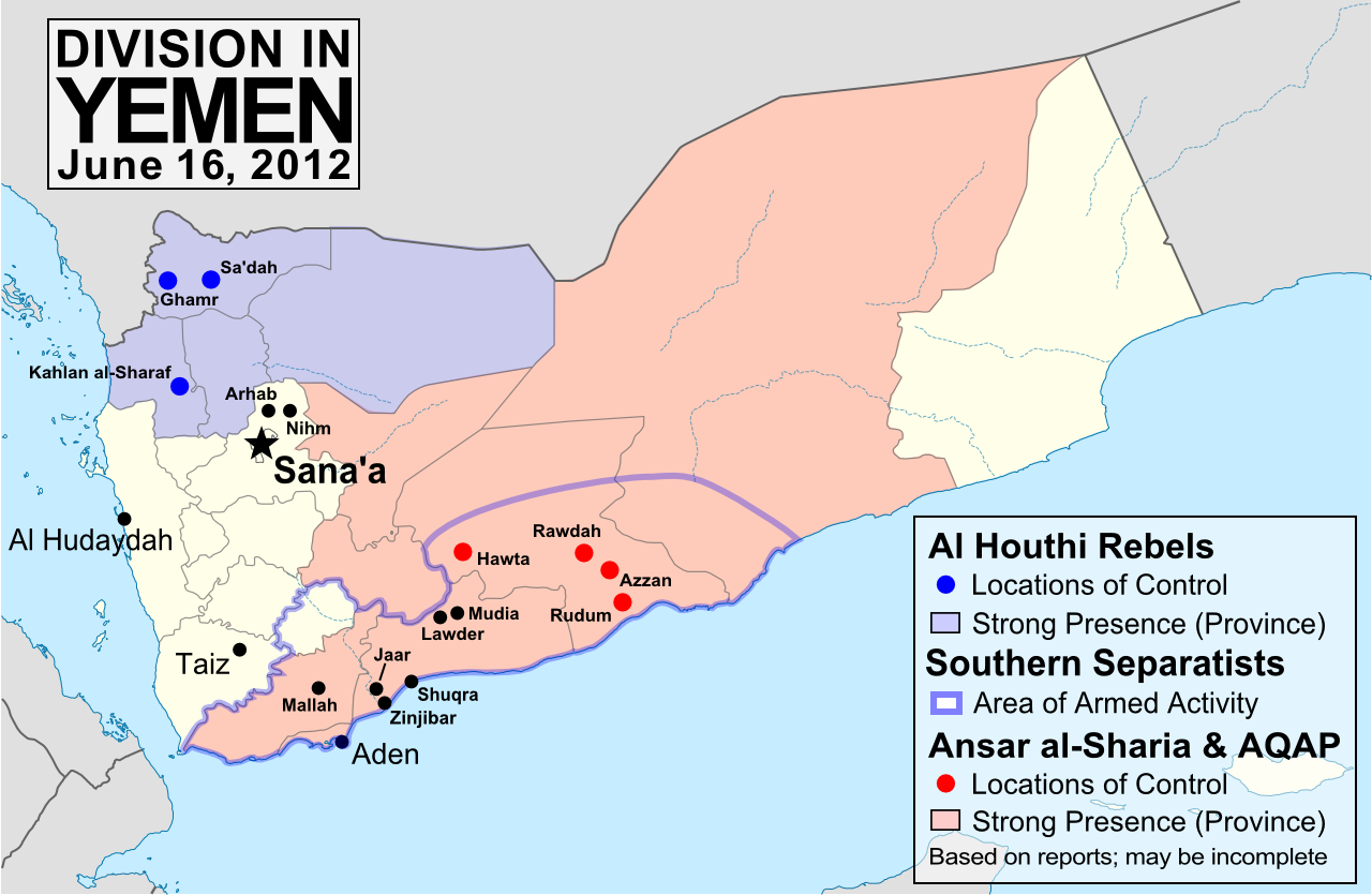
Map of division in Yemen, including control by Al Qaeda or Ansar al-Sharia, the Houthi rebels, and the Southern Movement. Update for June 2012.
Presence of anti-government forces in Yemen in June 2012. Ansar al-Sharia is part of Al-Qaeda in the Arabian Peninsula (AQAP). Map by Evan Centanni, using this blank map by NordNordWest/Wikipedia (license: CC BY-SA).

Note: To see previous Yemen map updates, or to check for new ones, view all Yemen posts on Political Geography Now.

Yemen vs. Al Qaeda

In the three months since our last Yemen update, the national army has been engaged in heavy fighting against Ansar al-Sharia, a front group of Al Qaeda in the Arabian Peninsula (AQAP) which has controlled large areas of Yemen’s south since the chaos of last year’s popular uprising. In some southern towns, Ansar al-Sharia has set up “Islamic Emirates” administered independently of Yemen’s government, with its two most prominent strongholds in Zinjibar and Jaar (renamed “Waqar”).

Flag of Al Qaeda, flown by Ansar al-Sharia in its Islamic emirates in southern Yemen.
Flag flown by Ansar al-Sharia in its emirates – the war banner of Al Qaeda, based on Muhammed’s Black Standard. Public domain graphic by Ingoman (source).

The Al Qaeda fighters at first defied the Yemeni forces, taking new territory in Shabwah province’s Rudum District, and temporarily capturing an army base in the area of Mallah at the end of March. They have also gradually expanded operations into Marib province and the southern port city of Aden. However, the tables began to turn in May, as the government of President Abdo Rabbuh Mansur Al-Hadi launched a major offensive against the Islamic extremists – with support from the U.S., including air strikes by armed drones.

First, Ansar al-Sharia was completely driven out of the Lawder and Mudia areas, whose town centers had already been defended for many months by “Popular Resistance Committees” (community militias opposed to Al Qaeda, who also played a key role in the recent victory). Then, early this week, Yemen’s army finally captured Zinjibar and Jaar, key strongholds which the militants had held for over a year. The last Al Qaeda territory in Abyan province, the port town of Shuqra, fell into government hands on Friday. The neighboring province of Shabwah remains largely under the control of Ansar al-Sharia, though none of their “emirates” there are as strategically useful as Jaar or Zinjibar.

Other Rebels in Yemen
The Houthi rebels, an army of Zaidi Shiite dissidents who have been fighting the government for years, still control most of Sa’dah province in the north, and exert their power in the surrounding regions as well. They refused to put down their weapons when Yemen’s popular uprising ended in February, but have agreed to join upcoming talks on the future of the country. Efforts are under way to convince the Southern Movement secessionists to join the dialogue as well.

Meanwhile, fighting has sprung back up between the Yemeni military and local militias in the north of the capital, Sana’a. The districts of Arhab and Nihm, which fought in solidarity with anti-government protesters during much of last year, have once again been shelled repeatedly by the military. This action strikes a sharp contrast with President Hadi’s efforts at national unity, and it has been alleged that the conflict is being waged in defiance of the president’s orders by Ahmed Ali Abdullah Saleh, commander of the Republican Guard and son of the deposed former president.

Map showing the location of Yemen on a globe
Location of Yemen (public domain; source)

Appendix: Alternative Spellings
Because there is no single standard way to spell Arabic names in English, many of the place names in this article have multiple possible spellings. Here are some alternate spellings used in the media:

Jaar – Ja’ar
Lawder – Lawdar, Loder
Mudia – Maudia, Mudiya, Mudiyah, Modia
Rudum – Radum
Sa’dah – Saadah, Saada
Shuqra – Shuqrah, Shaqra, Shaqrah, Shakra
Zinjibar – Zunjubar

Feature: Queen Elizabeth’s 16 Countries

Did you know that Elizabeth II is not just the Queen of England and the UK, but of 15 other independent countries too? Read on for quick answers to all your questions about this unusual arrangement…

Map of the Commonwealth Realms - independent countries that share the British monarchy.
Map of the Commonwealth realms – independent countries which share the British monarchy. Current realms in dark blue, former realms in light blue. By Evan Centanni, modified from public domain Wikipedia map (source).

Which countries share the Queen?
Her Majesty Queen Elizabeth II is the official head of state for 16 different independent countries, known as the “Commonwealth realms” – a smaller club than the Commonwealth of Nations, many of whose members are now queenless republics. The current Commonwealth realms, in order of independence, are:

Personal flag of Queen Elizabeth II
Personal flag of Queen Elizabeth II (source) License: CC BY-SA.

 United Kingdom
 Canada
 Australia
 New Zealand
 Jamaica
 Barbados
 The Bahamas
 Grenada
 Papua New Guinea
 Solomon Islands
 Tuvalu
 Saint Lucia
 Saint Vincent and the Grenadines
 Belize
 Antigua and Barbuda
 Saint Kitts and Nevis

Just as the sun never sets in the British Empire, the monarchy never set in the realms – each one inherits the queen’s role from its time as a former British colony (with the exception of northern Papua New Guinea, which passed directly from German to Australian control before uniting with the British south in independence).

Sixteen countries – is that all?
Although the independent realms total 16, the number of “countries” with Elizabeth II as their queen actually increases to 19 when including the four “home nations” that make up the U.K.: England, Scotland, Wales, and Northern Ireland. But that’s not all – as if 16 realms weren’t enough for one woman, the Queen of England also reigns over three Crown Dependencies (Guernsey and Jersey in the Channel Islands, plus the Isle of Man) and the 14 British Overseas Territories, all of which are dependent on the U.K., but aren’t considered part of the kingdom itself. And interestingly, the Realm of New Zealand includes two associated states, the Cook Islands and Niue, which could remain royal subjects even if New Zealand itself were to fire the queen from its government.

Map of the entire reign of Queen Elizabeth II (1952-2012), marking current and former realms and territories.
Entire reign of Queen Elizabeth II (1952-2012). Current in red, former in blue (dark = sovereign realm; light = territory or dependency). Click to enlarge. Excludes Antarctic claims. By Evan Centanni, from public domain map (source).

Historically, there are about 20 more countries which were Commonwealth realms during parts of the last Century, but have since abandoned the monarchy to become republics. Still, the current list is longer than it used to be – at the time of Queen Elizabeth II’s coronation in 1952, there were only seven realms: the U.K., Australia, Canada, New Zealand, Pakistan, South Africa, and Ceylon (now Sri Lanka).


How can countries share the same monarch and still be sovereign states?
Every one of the Commonwealth realms is a fully-fledged independent country and a member of the U.N., despite sharing the same queen. So how does that work? Each country has separately and independently designated Elizabeth II (and her royal line) as its head of state, and the British parliament has no authority whatsoever over the governments of any of the other realms. In a certain legal sense, these 16 countries just happen to have chosen the same family to form their monarchy.

To show this independence, each realm calls the queen by its own national title – she is not only the the Queen of England, but the Queen of Australia, the Queen of Canada, the Queen of the Bahamas, etc. As for Her Majesty, she’s been said to be “equally at home in all of her realms”. But since she has only has one physical body, she still mainly lives in the oldest realm: the U.K. In her other countries, she’s represented on an everyday basis by appointed viceroys (the highest-level viceroys are called governors-general).

But if they’re all controlled by the same person, isn’t that like being one country?

Flag of Elizabeth II, Queen of Barbados
Flag of Elizabeth II, Queen of Barbados. See all flags of Elizabeth II. By Barryob (source). License: CC BY-SA.

Unlike in medieval personal unions, where a single monarch had power over two or more countries, the queen has next to no power in her modern realms. Although there are some decision-making powers ceremonially assigned to her, for the most part she can now only exercise them if asked to by the country’s government. Since modern constitutional monarchies require the royal family to stay out of politics, the queen serves as a symbol of a loyalty to one’s nation that transcends political differences.

Still, this must create some awkward situations now and then, right?
Absolutely – since the queen mainly acts only on the “advice” of her countries’ governments, she officially takes both sides whenever two realms disagree, and has also been found engaging in trade competition with herself. She may also be simultaneously neutral and at war when one realm is involved in an international conflict and others are not; in extreme cases, the monarch of the Commonwealth realms may even declare war against him or herself, as happened in the Indo-Pakistani War of 1947 (during the reign of King George VI).

Learn More: The Commonwealth of Nations includes a lot more than just the Realms – so what is it, exactly?

Syrian Uprising: Update 4

There are newer versions of this map available. To see them, view all Syria updates.

Full Story: See Syria Divided by Armed Conflict

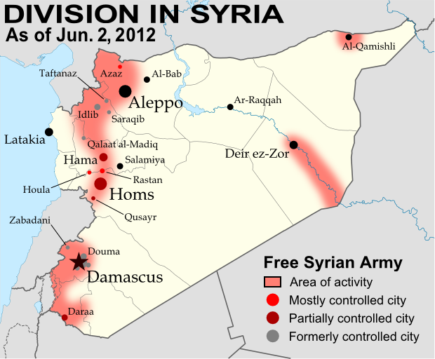
Map of Syria's uprising, marking cities and towns under control of the Free Syrian Army rebels as of June 2, 2012. Includes the site of the recent Houla massacre.
Known areas of armed activity for the rebel “Free Syrian Army” (click to enlarge). My own work, starting from this blank map by NordNordWest. License: CC BY-SA

Wondering what’s been going on in Syria since our last map update? There have been few, if any, major changes in territorial control, but here’s a brief status update. 

Despite the U.N. brokered ceasefire between the Syrian military and the rebel Free Syrian Army, which was to enter in effect on April 10, armed clashes have continued in many parts of the country, including recent heavy fighting in Rastan. Bloodshed reached a horrific peak a week ago, as over one hundred civilians – nearly half of them children – were massacred in the Houla area of Homs province. Witnesses told the U.N. that the murders were committed by militias loyal to President Assad, though the Syrian government attempted to blame the atrocity on the rebels. In the aftermath, one commander of the Free Syrian Army threatened to call off the ceasefire altogether, which could mean increased fighting in the coming weeks.

Country Name:  
• Syria (English)
• Sūriyya/Sūryā (Arabic)
Official Name:  
• Syrian Arab Republic (English)
• al-Jumhūriyyah al-‘Arabīyah  as-Sūriyyah (Arabic)
Capital: Damascus

Territorial control by the government and rebels has remained mostly the same since April. The only change made to the map is the addition of Houla in red, as at least one source indicates the area was under rebel control both before and after the massacre. Note that the Free Syrian Army is also reported to control much of the northwestern Idlib province outside of the main cities, though the situation is fluid and information is scarce, making it difficult to mark anything definitively on the map. 

Map: Sudan & South Sudan’s Disputed Territories

Countries: South Sudan, Sudan
Official Names: Republic of South Sudan, Republic of Sudan
Summary: After South Sudan declared independence from Sudan last year, much of the border between the neighbors is still hotly disputed, with recent violent clashes around the Heglig oil field and other areas. Read on for a full list of Sudan and South Sudan’s eight major border flashpoints.

Map of the border between Sudan and South Sudan, marking selected territorial disputes and border clashes in 2012. Includes inset map of April fighting in region of Heglig oil field.
Border map of Sudan and South Sudan, showing disputed areas and fighting since the beginning of 2012. Aerial bombings and attacks by rebel groups not shown. My own work, using blank Sudan and South Sudan maps by NordNordWest / Wikipedia. License: CC BY-SA.


About the Sudan-South Sudan Border Conflict
Nearly one year after South Sudan separated from Sudan, the precise location of the border between the two countries has still not been agreed upon and demarcated (marked on the ground). An approximate border line has been drawn on the map following the route of an old internal boundary between the northern and southern regions of colonial Sudan – known as the “1956 border”, for the last date it was in effect before Sudanese independence. But its implementation is so messy that the two sides can’t even agree on how much is disputed, with Sudan claiming that 80% of the border has already been effectively agreed upon, while South Sudan says it’s only 40%. Last month, tensions boiled over into a small border war centered on Heglig, a northern-administered oil town claimed by South Sudan. Fighting spread briefly to other border areas, and many locations in the south were bombed by Sudanese planes.

Photographs: Pete Muller on the Sudan-South Sudan front lines

The following article profiles eight hotly contested or widely acknowledged disputed areas along the border between Sudan and South Sudan. (Note on spellings: Many of these place names come from Arabic or other local languages, and do not have agreed-upon English spellings. Alternate spellings are indicated in parentheses).

Heglig (Panthou)
(Also spelled Higlig or Hijlij)
The small, remote oil town of Heglig, known as Panthou to South Sudan, is apparently located on northern Sudan’s side of the 1956 border. However, older maps don’t label the town at all, and until 2003 it was administered as part of Unity State in the Southern Sudan region. Then, just after the Sudan government and the future independent South had agreed not to share oil from north of the border, the government abruptly informed the southerners that Heglig in fact belonged to the north’s Southern Kordofan state.

Further Reading: Note on Panthou/Heglig (PDF) – History and legal status
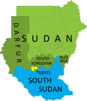
Map of current administrative areas of the former Sudan, distinguishing South Sudan, Sudan (plus areas with active rebellions), and the disputed Abyei area, which is jointly administered and policed by U.N. peacekeepers.
The former Sudan’s current administrative areas. Blue: South Sudan. Green: Sudan (darker green: states with active rebellions). Yellow: joint administration and U.N. peacekeeping force. Modified from this map by Wikimedia user Lokal_Profil (CC BY-SA 2.5).

Minds in the south weren’t changed so easily, and after two weeks of border clashes starting in late March of this year, South Sudan invaded Heglig. The southern government claimed they were only retaliating against earlier attacks by the north, but Sudan and the U.N. denounced it as an act of aggression. The South Sudanese army occupied Heglig from April 10-20, and advanced nearly as far as Kharasana (also Kersana, Karasana, Karasanah) before turning back – whether out of defeat or in order to stem international criticism is not clear. The front line has since moved back to Teshwin (also Tachiuen, Tishwin, Tashwin), an uninhabited spot on the 1956 border. Sudanese air strikes during the confrontation occurred deep within South Sudanese territory (PDF), including in Unity State’s capital of Bentiu, as well as Panakuac (also Pan Akuach, Pana Kuach), a military position on the road to Teshwin.

Video: Journalists witness Sudanese air raid

Abyei Area
Perhaps the most well known of the disputed regions along the border of the two Sudans, this region was singled out for special treatment in the 2005 agreement which led to Southern independence. Centered around the town of Abyei, the territory was to have its own referendum vote on whether to join South Sudan or remain part of the north. However, due to disagreements last year over who could to vote, the referendum failed to happen and the northern Sudanese Armed Forces (SAF) occupied the territory. Abyei is officially co-administered by the north’s South Kordofan state and the south’s Northern Bahr el Ghazal state, with security handled by a U.N. peacekeeping contingent called UNISFA; however, the part of the area north of the Bahr el Arab (Kiir) River is still occupied by the Sudanese army (PDF). South Sudan until recently maintained a police force in the area south of the river, but pulled it out two weeks ago at the demand of the U.N. Security Council (the north has defied the same order). [Update: Sudan finally withdrew its troops from Abyei on May 29.]

Kafia Kingi area
(Also spelled Kafia Kinji, Kafiya Kinji)
This is the largest of the regions disputed between Sudan and South Sudan, with its own confused history. Sudan seems to have transferred the area from the south’s Western Bahr el Ghazal state to the north’s South Darfur state in 1960 – too late to make it part of the north under the 1956 borders. However, some documents suggest it may have already been transferred by the British in the 1930’s (before 1956, making the transfer still valid today). In addition to the town of Kafia Kingi itself, the area also includes the copper mining town of Hofrat en Nahas (also Hufrat an Nuhas, Hufrat al Nahas) and the border town of Kafan Dabi (also Kafindabei, Kafn Dubai, Kafan Dibi), which was recently “recaptured” by the north.

Further Reading: Contested Borderlands: The Kafia Kingi Enclave
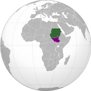
Map showing location of Sudan and South Sudan on a globe.
Location of Sudan (green) and South Sudan (purple) in Africa. Modified from this map (license: CC BY-SA).

Jau
(Also spelled Jao, Jaw)
Located right on the north-south border, this town on the frontier of Unity State and South Kordofan rose briefly to prominence after South Sudan claimed Sudan occupied their territory there last December, eventually leading to a victorious southern campaign to recapture the town in February. Rebel groups in the north simultaneously claimed credit for the victory, reinforcing Sudan’s accusation that the rebels are supported by the South Sudan government.

Bahr el Arab (Kiir) River
Called “River of the Arabs” by the north, and the Kiir River by the South, this is a locally important waterway that intersects the Abyei Area after running somewhat north of the 1956 border for a few hundred kilometers through South Darfur state. However, locals insist that the river is the real border, though it is unclear whether the South Sudan government itself actually claims the south bank. During last month’s outbreak of border warfare, fighting occurred in the riverside village of Kiir Adhem (also Kiir Adem, Kiir Adham), as well as a location known as Warguet, north of Aweil town in Northern Bahr el Ghazal state.

Kaka
This town on the White Nile river is located south of the 1956 boundary, within the state of Upper Nile. However, during the colonial era, the British allowed the town’s port to be administered by what is now Sudan’s Southern Kordofan state, and northern farmers over time established themselves in the Kaka area as well. South Sudan, however, argues that the town’s northerner administration did not make it technically a part of the north. Kaka has not been a flashpoint for fighting in recent months, but it remains on an agreed-upon list of disputed border areas. (Source: International Crisis Group report on Sudan north-south border)

Megenis Mountains
(Also Jebel Megenis, Magenis, Al-Muquinis Mountain)

Flag of Sudan (source)

An outcropping of large hills rising several hundred meters over the surrounding plain (Google Maps), the Megenis Mountains are divided between Sudan’s White Nile and South Kordofan states and South Sudan’s Upper Nile state. Sudan claims the whole area as the traditional realm of one of its local peoples, but there are also rumors of oil lying beneath the ground, and this may be the real reason that Megenis remains on the list of territorial disputes. (Source: International Crisis Group report on Sudan north-south border)

Flag of South Sudan (source)

Jodha
(Also spelled Jordah, Goda)
This dispute arises from a history of multiple changes to the border between Renk County in the south’s Upper Nile state and Jebeleyn (or Jabalain) County in the north’s White Nile state. Although locals dispute the whole eastern half of the boundary between the two states, the governments of Sudan and South Sudan designated only a small area near the present-day border crossing of Jodha as a recognized territorial dispute. (Source: International Crisis Group report on Sudan north-south border.) During last month’s widespread border conflict, fighting broke out in the nearby town of Kuek, though some sources claimed South Sudan’s army faced an independent militia rather than the Sudanese Armed Forces.

Sources for map locations:
Situation Map: Sudan-South Sudan border areas (27 April, 2012) (PDF). U.N. Office for the Coordination of Humanitarian Affairs (OCHA).
Policy Briefing: Sudan: Defining the North-South Border. International Crisis Group.
Map of Southern Kordofan and Abyei. U.N. Cartographic Section.
South Darfur Planning Map: All Settlements. Humanitarian Information Center for Darfur.  
Sudan: Population Movement. International Federation of Red Cross and Red Crescent Societies.

Kosovo Recognition Update (Total: 90/193)

Country Name: Kosovo (English, Serbian), Kosova (Albanian)
Official Name: Republic of Kosovo (English), Republika e Kosovës (Albanian),
Republika Kosovo (Serbian)
News Categories: Recognition, Partially Recognized States, Breakaway States
Full Story: See Kosovo Diplomatic Recognition Continues

Map of countries that recognize the Republic of Kosovo as independent
Countries recognizing the Republic of Kosovo in green, with arrows marking the two most recent: São Tomé and Príncipe (left) and Brunei (right). Kosovo in magenta. Modified from public domain wiki map (source).

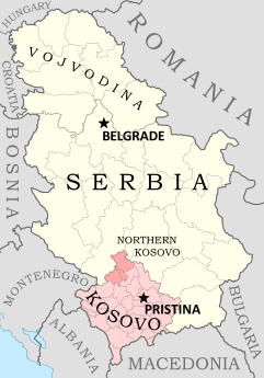
Map of Kosovo within Serbia
Kosovo, claimed as a province of Serbia, is
policed by U.N. and E.U. peacekeepers. The
Republic of Kosovo also governs the region,
except for the Serbian-loyalist north. Map is
my own work, based on these two blank
maps by Nord-NordWest. License: CC BY-SA


Kosovo Recognition Update
Since our last report on the disputed Republic of Kosovo, news has broken on two more U.N. member countries recognizing Kosovan independence. The first, the Democratic Republic of São Tomé and Príncipe, recognized the self-declared European republic on March 13 (before our last article, but the news didn’t trickle out in time to include it). São Tomé and Príncipe is a tiny, Portuguese-speaking island country located off the western coast of Africa. The second recognition came just one week ago, on April 25, from the state of Brunei Darussalam (“Brunei” for short), a small kingdom located on the island of Borneo in Southeast Asia. Kosovo is now recognized by 90 U.N. member countries (46% of the total 193), as well as non-member Taiwan. The Republic of Kosovo has not been admitted as a member of the U.N.

Stay Updated: Check for more recent posts by viewing all Kosovo articles on Political Geography Now.

Sources:  
2012-3-13. Resolution from the government of  São Tomé and Príncipe (PDF) (Portuguese)
2012-4-25. “Brunei Darussalam recognizes Kosovo independence”. Ministry of Foreign Affairs of the Republic of Kosovo.

Syrian Uprising: Map Update 3

There are newer versions of this map available. To see them, view all Syria updates.

Country Name: Syria (English), Sūriyya/Sūryā (Arabic)
Official Name: Syrian Arab Republic (English),
al-Jumhūriyyah al-‘Arabīyah as-Sūriyyah (Arabic)
News Category: Divided Countries
Full Story: See Syria Divided by Armed Conflict

Map of Syria, showing control by the rebel Free Syrian Army as of April 10, 2012
Known areas of armed activity for the rebel “Free Syrian Army”, marking controlled cities and notable towns.
Many rural areas may also be under full rebel control. Unarmed protests not shown. Map is my own work,
starting from this blank map by German Wikipedia user NordNordWest. License: CC BY-SA

Syria Conflict Update
In the three weeks since our last Syria update, the Syrian military has continued its campaign to retake the northern province of Idlib from the rebel Free Syrian Army (FSA). Having retaken Idlib city earlier in the month, the government forces then targeted the province’s second largest city, recapturing Saraqib (Saraqeb) after a four-day battle ending on March 28. In an offensive which is still ongoing despite plans for a U.N.-brokered ceasefire, the Syrian military has also overrun a number of previously rebel-held towns and villages in the Idlib area, most recently taking the town of Taftanaz in an especially bloody battle this week.

Meanwhile, a new front has opened up in the north of Aleppo province, where according to some reports the rebels have controlled the city of Azaz and other towns since early March. In central Syria, the battle continues for the city of Homs, of which the FSA still controls some northern areas. The historical site of Qalaat al-Madiq (Madiq Castle) in Hama province also made news at the end of last month, as the Syrian army stormed the town after a two week siege (government-friendly media later reported that the town had been completely captured).

Useful Link: Wikipedia – Timeline of the 2011-2012 Syrian Uprising