Rebel Control Map: Central African Republic’s Counter-Rebellion (September 2013)

Map of 2013 counter-rebellion in the Central African Republic, showing current control by anti-Séléka (possibly pro-Bozizé) rebels as known on September 11, 2013.
Little sooner than Séléka rebel leader was sworn in as president, a new counter-rebellion has sprung up in the Central African Republic. Map by Evan Centanni from this map by Wikimedia user Keitsist. License: CC BY-SA

Previously: Séléka Coalition Takes Control of Central African Republic (Map of Rebel Advance)

Rebellion and Counter-Rebellion
Starting last December, a rebel coalition called Séléka swept across the Central African Republic from the north, capturing much of the country by January (see our first map of rebel control in the CAR). After a short-lived attempt at peace, Séléka renewed its campaign, capturing the capital and forcing President François Bozizé to flee the country. Rebel leader Michel Djotodia declared himself president, and Séléka has remained the major power in the country despite outbreaks of violence and general chaos.

Flag of the Central African RepublicCountry Name:  
• Central African Republic (English)
• Centrafrique (French)
• Bêafrîka (Sango)
Official Name:  
• Central African Republic (English)
• République centrafricaine (French)
• Ködörösêse tî Bêafrîka (Sango)
Capital: Bangui

Djotodia consolidated his power with an official presidential inauguration last month, but the conflict has proven to be far from settled. This Monday, heavy fighting broke out near Bossangoa, a city in the northwest, with anti-Séléka rebels reportedly taking over six unspecified towns in the area. Djotodia’s government said Bouca was one of the captured towns, while blaming the uprising on supporters of former president Bozizé.

The area is indeed Bozizé’s home region, though the rebels may not all be his supporters. A newspaper from Ghana reported that the rebels called themselves Anti-Balaka, which it translated as “Anti-Machete”. The same report also indicated that Bossangoa itself had fallen under rebel control, though other sources only state that fighting is ongoing in the surrounding villages as the city is being abandoned by fleeing civilians.

Stay tuned to Political Geography Now’s Central African Republic channel for updated maps of this evolving situation!

Related:
Syrian Civil War Control Map
Map of Nigeria’s War on Boko Haram
War in Somalia: Map of Al Shabaab Control

Graphic of the flag of the Central African Republic is in the public domain (source).

Lies Your World Map Told You: 5 Ways You’re Being Misled

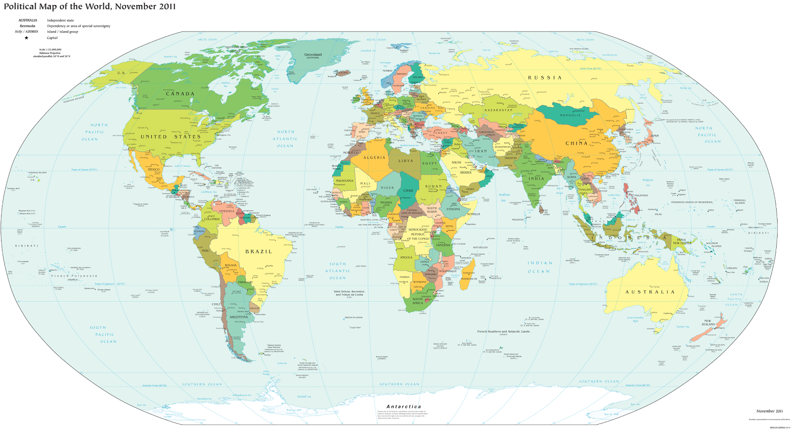
Unfortunately, most world political maps aren’t telling you the whole story. The idea that Earth’s land is cleanly divvied up into nation-states – one country for each of the world’s peoples – is more an imaginative ideal than a reality. Read on to learn about five ways your map is lying to you about borders, territories, and even the roster of the world’s countries.

Map of the world's countries according to the U.S. Central Intelligence Agency
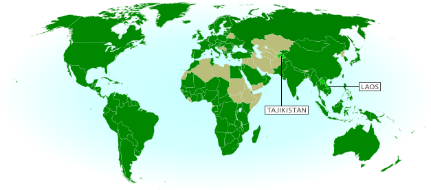
The lines and coloring on this map are hiding major truths about the world’s countries.
(Source: U.S. CIA; public domain)

1) Missing Countries
When choosing what counts as a country, most world maps go by either the official list from their own country or the member/observer roster from the United Nations. Just one problem: there are about ten countries which have declared and enforced their independence, but aren’t recognized by the U.N. or most of the world’s governments. These states may have close ties to a neighbor country, but most of them aren’t at all controlled by the country they’re supposed to be part of.

Map showing Abkhazia and South Ossetia, two breakaway states claimed by Georgia.
Abkhazia and South Ossetia operate as independent countries, but are claimed by Georgia and only recognized by a few countries. Map by Ssolbergj (CC BY-SA).

There are some high-profile special cases that warrant at least a note on many maps. Taiwan’s government formally claims to represent non-communist China, though it acts more like a separate country. Palestine, another disputed state, is now recognized as a U.N. observer country despite being forced to share control of its territory with Israel.

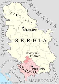
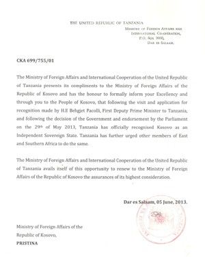
Western Sahara‘s status is considered unresolved by the U.N., and a small piece is effectively independent; meanwhile, Northern Cyprus is recognized only by its patron country, Turkey. The self-proclaimed Republic of Kosovo is now recognized by half of the U.N.’s members but not by the U.N. itself.

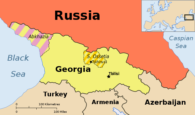
Other countries escape entirely from all but the most careful of political maps, being misleadingly merged into the countries that claim their territories: Abkhazia and South Ossetia into Georgia, Nagorno-Karabakh into Azerbaijan, and Transnistria into Moldova. These four breakaway states are sponsored by neighboring countries, but the most left out of all is Somaliland, which receives no major support or recognition from anyone, despite managing its affairs completely independently from Somalia.

Unrecognized Countries: More Articles and Maps

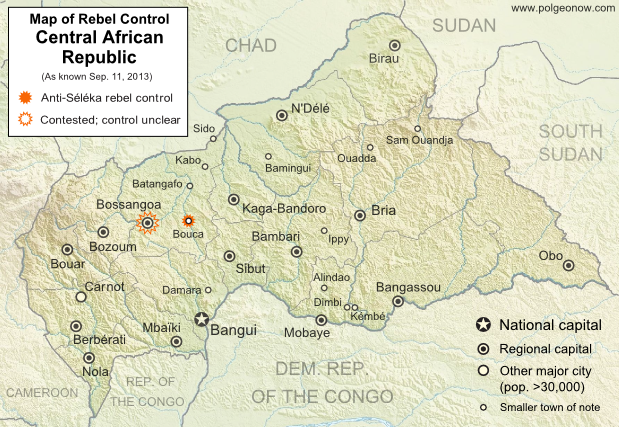
2) Incomplete Control
Drawing lines around a country on the map might imply that its government controls all the land within those lines. But that’s often not the case in reality. Even setting aside foreign military occupations like the recent U.S. interventions in Iraq and Afghanistan, many countries’ governments don’t control their whole territories. Aside from the cases of breakaway states as described earlier, this mainly occurs in war zones where rebel groups are actively vying for control of all or part of the country.

Map of government and Al Shabaab control in Somalia's ongoing civil war
Large parts of Somalia are controlled by Al Shabaab extremists. Click for map attribution info (CC BY-SA).

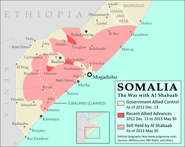
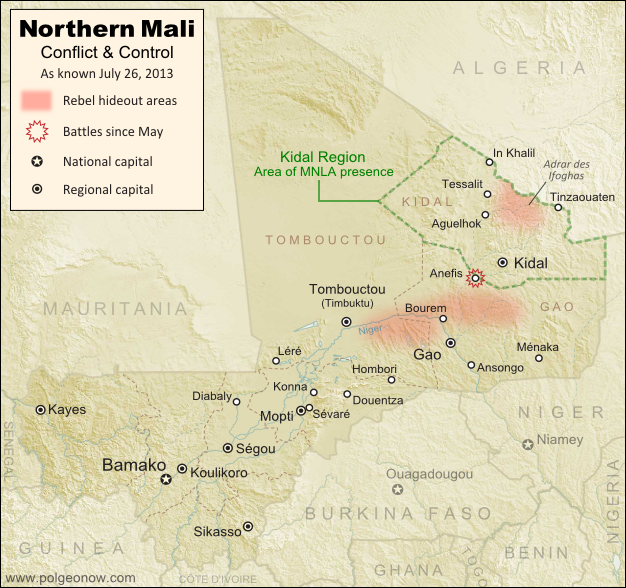
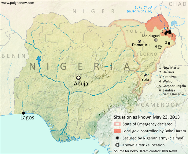
Somalia is probably the most infamous for this. Its U.N.-recognized government controls around half the country at best, and a few years ago controlled nothing but a part of the capital city! The rest is divided between the religious extremist Al Shabaab and various autonomous states which keep their own counsel on whether to cooperate with the government.

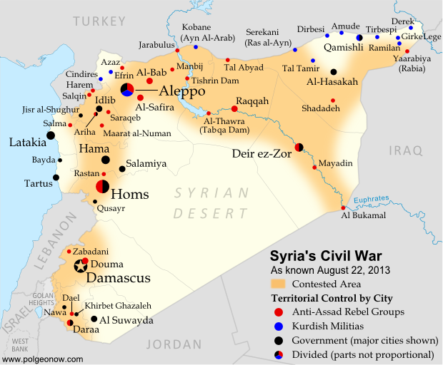
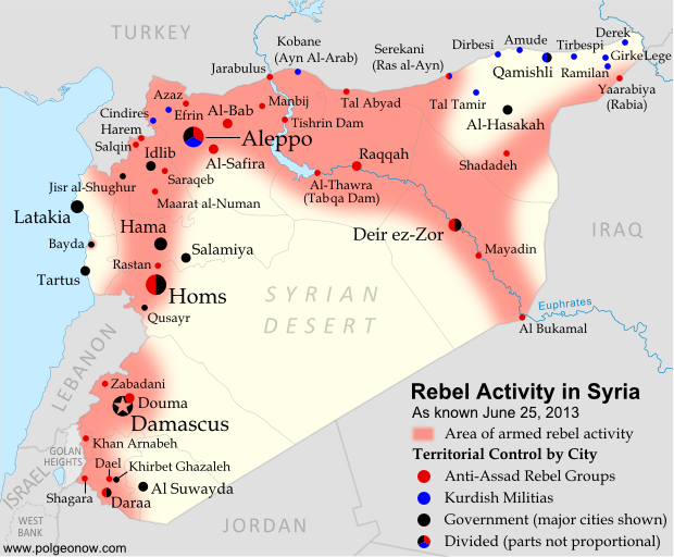
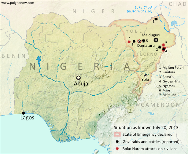
The territories of Mali, Nigeria, the Central African Republic, Libya, and Ivory Coast have all only recently been reunited (either under the former government or under the rebels), and Syria is the current model of a state falling apart through violence. Other countries with rebels firmly controlling parts of their territory are Yemen, the Democratic Republic of the Congo, and Myanmar/Burma.

Divided Countries: More Articles and Maps

3) Undefined Borders

Map of the border dispute recently resolved between Niger and Burkina Faso
Niger and Burkina Faso recently resolved an unclear border situation. Map by Evan Centanni (click for details; CC BY-SA).

Another thing political maps imply is that borders at least have strictly defined locations in principle, even if they’re usually invisible on the ground. If they weren’t well-defined, they wouldn’t all be drawn with solid lines on the map, right? Wrong. Many countries have borders that have never been precisely defined by treaties, a process called “delimitation”.

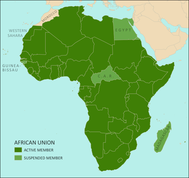
Even fewer have been actually “demarcated”, or marked on the ground. In fact, undefined borders are such a big issue among the relatively young countries of Africa that the African Union operates an official border program to encourage the ongoing delimitation of national boundaries.

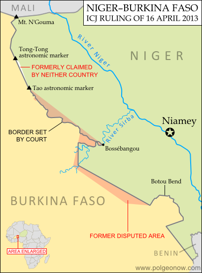
The fudge factor in national borders isn’t always big enough to make a difference to where they’re drawn on the world map – but their fuzziness can sometimes have major effects on international relations. An undefined border is a ripe environment for the birth of territorial disputes when neighboring countries have different ideas of where the border should run.

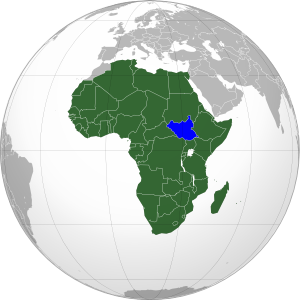
Sometimes these disputes are only low-level disagreements, such as the one recently resolved between Niger and Burkina Faso; but in other places like the border between Sudan and South Sudan, they can escalate into bloody conflicts.

Undefined Borders: More Articles and Maps

4) Disputed Territories
Your world map may label a few well-known territorial disputes, caused either by vague borders or conflicts over island groups. You might then reasonably conclude that disagreements over who owns a place, though they do happen, are relatively few and far between. Unfortunately, your conclusion would be incorrect. There are far more disputed territories in the world than you’ve probably ever imagined.

Map of the Senkaku/Diaoyu Islands, controlled by Japan but claimed by China and Taiwan
Map of the Senkaku/Diaoyu Islands, disputed between Japan, China, and Taiwan (map by Evan Centanni).

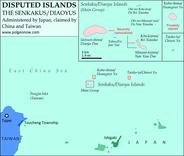
The most bizarre disputes range from high-profile cases, such as the five-way feud over the Spratly Islands, to quieter anomalies like Bir Tawil between Sudan and Egypt, both of whom claim it belongs to the other.

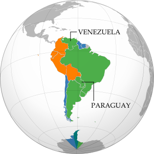
You may have heard of those, but did you know that (at least on paper) Mongolia is claimed by Taiwan? Or that more than half of Guyana is claimed by Venezuela? What about the several territories disputed between the U.S. and Canada? And those are just the land disputes – wait until you hear about the oceans!

Disputed Territories: More Articles and Maps
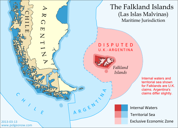
5) Territorial Seas
One thing completely left off of most maps is ownership of the sea. The occasional border lines you see across straits on your map are just showing who owns the islands on either side, not who owns the sea in between. The uninterrupted expanse of blue on most maps then might imply that the seas are the domain of no country. This is true for parts of the open ocean far from any coastline – but closer in, countries can and do exercise territorial rights over their neighboring seas. According to international best practices, a country is entitled to extend its territory up to 12 nautical miles (NM) out from its coastline, regulate economic activity out to 200 NM, and sometimes control seafloor oil and mineral exploration out to much further.

Map of territorial seas and exclusive economic zones (EEZ) around the Falkland Islands (Malvinas), controlled by the U.K. but claimed by Argentina
Both the land and the seas of the Falkland Islands are disputed between the U.K. and Argentina. Map by Evan Centanni (click for details; CC BY-SA).

But the divvying up of the world’s seas is still an ongoing process, and there are probably even more maritime disputes than land-based ones. Some countries, like Peru and Ecuador, refuse to recognize the 12 NM limit, claiming sovereign territory out to a full 200 NM. In even more cases, neighboring countries just can’t agree on where to draw the border between their respective territorial seas.

International law does provide guidance on how to divide it up, but for now many countries make claims far beyond what seems reasonable, apparently hoping they have something extra to give away in future negotiations. The most extreme claims, like China’s infamous “Nine-dotted Line” around most of the South China Sea, don’t seem to follow much legal logic at all.

Maritime Jurisdiction: More Articles and Maps

So next time you find yourself looking at a political map of the world, remember to be critical and take those borders with a grain of salt!

Other Articles You Might Like:
5 Countries You’ve Never Heard Of (by Their Native Names) 
How Many Countries Are There in the World?
Parade of Nations: Which Countries Are (and Aren’t) in the Olympics?
 

Syria Civil War Map: August 2013 (#11)

There are newer versions of this map available. To see them, view all Syria updates.

Syria’s civil war has continued to rage through the summer, with small changes in territorial control and the area of fighting. Here’s the updated conflict map, plus a summary of recent territorial changes and other developments.

Map of fighting and territorial control in Syria's Civil War (Free Syrian Army rebels, Kurdish groups, Al-Nusra Front and others), updated for August 2013. Includes recent locations of conflict and territorial control changes, including Salma (Latakia), Nawa (Daraa), and Ras al-Ayn (Hasakah).
Area of fighting and territorial control in Syria’s civil war, updated for August 2013. Map by Evan Centanni, starting from this blank map by German Wikipedia user NordNordWest. License: CC BY-SA

Latest Fronts
Over the last two months since our previous Syria war map, fighting increased in three different corners of the country. In the northwest, rebels pushed farther into the coastal province of Latakia, a stronghold of President Bashar al-Assad and his native Alawite ethnic group. The rebel forces captured and briefly held several Alawite villages in the mountains before being pushed back to their base in Salma.

Meanwhile, fighting has heated up in the already contested Daraa province of southwestern Syria. Most notably, the rebels stormed the major town of Nawa in July, before losing it to the Syrian army again this month. In the country’s opposite corner, the far northeastern province of Hasakah, Kurdish militias finally seized full control of Serekani (Arabic name: Ras al-Ayn) from religious extremist rebels who had been fighting for the town since last year. Apparently in response, the extremists have pushed farther into Kurdish territory elsewhere in the province.

Flag of Syria under the current governmentCountry Name:  
• Syria (English)
• Sūriyya/Sūryā (Arabic)
Official Name:  
• Syrian Arab Republic (English)
• al-Jumhūriyyah al-‘Arabīyah  as-Sūriyyah (Arabic)
Capital: Damascus

Fighting in Major Cities
Syria’s three largest cities have remained battlefields over the past months, with number-one metropolis Aleppo still bitterly divided between the government, the rebels, and Kurdish groups. The Syrian army has made further inroads into Homs, and now controls most but not all of the key central city.

While central Damascus remains mostly out of reach for the rebels, fierce battles have continued to be waged over the capital city’s many suburbs (see a map of rebel and government control in the city from two weeks ago).

Broad Trends
An expert quoted in a New York Times article last month estimated that Syria’s rebel groups now control 60-70% of the country’s land, but only 40% of the population, due to their greater success at controlling rural areas than holding major cities.

Meanwhile, the opposition remains as disorganized as ever, having proved unable to form a national-level interim government for the rebel-held areas. But the starkest sign of disunity between the various anti-Assad groups has been the breakout of major fighting between the secular-minded Free Syrian Army (FSA) rebels and the religious extremists of the Nusra Front and the ISIS (“Islamic State of Iraq and Syria”). The latter groups have emerged as the strongest rebel force in many areas of Syria, driving the FSA out of Raqqah city as part of their rise in power across the country’s north and east.

Small Adjustments
This edition of the map returns to showing Ariha, a major town in Syria’s northwestern province of Idlib whose status had been unclear for many months. Recent reports indicate that it is divided between rebel and government control. In central Syria, the war has now reached the previously peaceful city of Salamiya, which was shelled by rebel forces two weeks ago.

Similar Articles:
Syria Civil War Map: June 2013 (#10)
Mali Conflict Map: National Territory Reunited
War in Somalia: Map of Al Shabaab Control

Graphic of the Syrian flag is in the public domain (source).

Map: Kosovo Recognized by 4 More Countries (101/193)

Map of countries that recognize the Republic of Kosovo as an independent state, updated for August 2013 with most recent additions and disputed recognitions highlighted
Countries recognizing the Republic of Kosovo in green, with the four most recent additions highlighted. Disputed recognitions in yellow. Kosovo in magenta. Map by Evan Centanni, modified from public domain graphic (source).

Flag of the Republic of KosovoCountry Name:  
• Kosovo (English, Serbian)
• Kosova (Albanian)
Official Name:  
Republic of Kosovo (English)
Republika e Kosovës (Albanian)
Republika Kosovo (Serbian)
Capital: Pristina/Prishtina

By Evan Centanni

New Kosovo Recognitions
Over the past four months, the breakaway Republic of Kosovo has received diplomatic recognition from two more U.N. member countries. The self-proclaimed southeastern European country now claims recognition from 101 U.N. member countries (52%), up from 99 in our previous Kosovo recognition update (see “Disputed Recognitions” below for details on why the total has only been incremented by two).

Tanzania, a republic in East Africa, recognized Kosovo at the end of May, and nearby Egypt extended its recognition a month later (just days before the breakout of its current constitutional crisis). Yemen had already endorsed Kosovo’s independence earlier in June, and the small Central American country of El Salvador apparently followed suit by the end of the month.

The Republic of Kosovo declared independence from Serbia in 2008, but has been blocked from U.N. membership by objections from Serbia, Russia, and other countries who see its secession as invalid. In addition to the 101 U.N. members from whom Kosovo claims recognition, its independence is also acknowledged by non-U.N. member Taiwan. For more on Kosovo’s special situation, see our first Kosovo recognition report, which also includes a map of Kosovo’s location relative to Serbia.

Disputed Recognitions
As explained in our previous Kosovo recognition report, there has been doubt cast on some of Kosovo’s claimed recognitions. In fact, if the Kosovan government’s past disputed claims of recognition are included, the total number of U.N. member countries recognizing the breakaway state is now 103. However, a recent report from Kosovo’s foreign ministry only claims 101 U.N. member recognitions, even while acknowledging the four most recent additions. This suggests they may finally have given up on the questionable claims of recognition from  Nigeria and Uganda (the third disputed recognition, from São Tomé and Príncipe, is better documented). In any case, the total number of countries recognizing Kosovo now forms over half of the U.N. membership even without counting disputed recognitions.

Stay Up to Date: Check for further updates to this story by viewing all Kosovo articles on Political Geography Now.

Related Articles:
North Kosovo Status Changing After Serbia Deal
Kosovo Recognition Update: April 2013
Who Recognizes Palestine in 2013?
 

Flag graphic by Cradel (source). License: CC BY-SA

Japan-China Dispute: The Eight Islands of the Senkaku/Diaoyu Group (Aerial Photos)

Map of the Senkaku/Diaoyu Islands, disputed between Japan, China, and Taiwan; includes location as well as detail of islands
Map of the disputed Senkaku/Diaoyu Islands (by Evan Centanni). Click to view at full size.

Article by Evan Centanni

The Senkaku/Diaoyu Islands
A recent feature on Political Geography Now introduced the history and status of the Senkaku/Diaoyu Islands, a disputed territory controlled by Japan but claimed by China and Taiwan. The article included an original map which showed the isles’ configuration and precise location within the East China Sea (click on the map at right to see it at full size). But if you’re like me, you may be wondering “just how small are these islands, and what do they really look like?”

Luckily for you and me, aerial photographs of many places in Japan have been released by the Japanese government and uploaded with English labels to Wikimedia Commons. Included in the collection are shots of each of the disputed isles, known as the Senkaku Islands to the Japanese, the Diaoyu Islands to the Chinese, and the Diaoyutai Isands to the Taiwanese. Here are the photos and a brief profile of each island:

Aerial photo of Uotsuri-shima (魚釣島)/Diàoyúdǎo (钓鱼岛)/Diàoyútái (釣魚臺), the largest of the Senkaku/Diaoyu islands disputed between Japan, China, and Taiwan

Japanese: Uotsuri-shima (魚釣島)
Chinese (China): Diàoyúdǎo (钓鱼岛)
Chinese (Taiwan): Diàoyútái (釣魚臺)
Area: 4.32 km2 (1.67 mi2)
Highest Point: 383 m (1,257 ft.)
The largest isle in the disputed archipelago, Uotsori has been a center of historical activity in the Senkaku/Diaoyu Islands. It was the site of a Japanese fish-processing plant from about 1900-1940, when it hosted 200 workers. Since then it has been uninhabited, but was visited by a Japanese academic-governmental delegation for four weeks in 1979.

The island was one of four sold to the Kurihara family in the 1970s. The Japanese government rented the island from 2002, before finally buying it from the family last year. Though the island is no longer inhabited by humans, it is home to a population of domestic goats and albatross, as well as a species of mole found nowhere else on earth. Once called “Peaks Island” by the British, the current name means “Fishing Island” in both Japanese and Chinese (the name used by Taiwan is literally “Fishing Platform”). (photo source)

Aerial photo of Kita-kojima (北小島)/Běi Xiǎodǎo (北小島/北小岛) and Minami-kojima (南小島)/Nán Xiǎodǎo (南小島/南小岛), two major parts of the Senkaku/Diaoyu Islands disputed between Japan, China, and Taiwan

Japanese: Kita-kojima (北小島)
Chinese: Běi Xiǎodǎo (北小島/北小岛)
Area: 0.33 km2 (0.13 mi2)
Highest Point: 135 m (443 ft.)

Japanese: Minami-kojima (南小島)
Chinese: Nán Xiǎodǎo (南小島/南小岛)
Area: 0.46 km2 (0.18 mi2)
Highest Point: 149 m (489 ft.)
These are the only other major islands in the main cluster of the Senkakus. Like Uotsuri, they were sold to the Kurihara family in the 1970s, rented by the Japanese government from 2002, and bought by the government in 2012. The islands’ names are written the same in both Japanese and Chinese, and mean “Northern Little Island” and “Southern Little Island” respectively. (photo source

Aerial photo of Oki-no-Kita-iwa (沖の北岩)/Běiyǔ (北屿)/Chōng Běiyán (沖北岩)/Dà Běi Xiǎodǎo (大北小島)/Běiyán (北岩), group of rocks which form part of the Senkaku/Diaoyu Islands disputed between Japan, China, and Taiwan

Japanese: Oki-no-Kita-iwa (沖の北岩)
Chinese (China): Běiyǔ (北屿)
Chinese (Taiwan): Chōng Běiyán (沖北岩)
Other Chinese Names: Dà Běi Xiǎodǎo (大北小島), Běiyán (北岩)
Area: 0.02 km2 (0.01 mi2)
Highest Point: 28 m (92 ft.)
This is actually a small group of islets located in the northeast of the Senkaku Islands’ main cluster. It consists mainly of barren rocks, and has apparently never been privately owned. The Japanese and various Chinese names are variations on “Northern Islet” or “Northern Rock”; yet one name, Dà Běi Xiǎodǎo, means “Big Northern Little Island”, seeming ironically to imply that it outsizes the much larger Běi Xiǎodǎo (Kita-kojima). (photo source

Aerial photo of Oki-no-Minami-iwa (沖の南岩)/Nányǔ (南屿)/Chōng Nányán (沖南岩)/Dà Nán Xiǎodǎo (大南小島)/Nányán (南岩), group of rocks which form part of the Senkaku/Diaoyu Islands disputed between Japan, China, and Taiwan

Japanese: Oki-no-Minami-iwa (沖の南岩)
Chinese (China): Nányǔ (南屿)
Chinese (Taiwan): Chōng Nányán (沖南岩)
Other Chinese Names: Nán Běi Xiǎodǎo (大南小島), Nányán (南岩)
Area: 0.005 km2 (0.002 mi2)
Highest Point: 13 m (43 ft.)
Located at the eastern edge of the main cluster of the Senkaku Islands, this another barren rock which has apparently never been privately owned. Its names in Japanese and Chinese present it as the southern counterpart to Oki-no-Kita-iwa. (photo source)

Aerial photo of Tobise (飛瀬)/Fēiyǔ (飞屿)/Fēilài (飛瀨)/Fēiyán (飛岩)/Fēijiāoyán (飛礁岩), a reef which forms part of the Senkaku/Diaoyu Islands disputed between Japan, China, and Taiwan

Japanese: Tobise (飛瀬)
Chinese (China): Fēiyǔ (飞屿)
Chinese (Taiwan): Fēilài (飛瀨)
Other Chinese Names: Fēiyán (飛岩), Fēijiāoyán (飛礁岩)
Area: 0.0008 km2 (0.0003 mi2)
Highest Point: 2 m (7 ft.)
Tobise is a cluster of rocks located just southeast of Uotsuri, the biggest island of the Senkakus. Although the area of shallow water surrounding it gives it a larger profile on some maps, according to the Taiwan government’s measurements it is the smallest of the eight major named isles of the Senkaku/Diaoyu Islands. It is also the lowest, protruding little farther above the water than the height of a person. Its Japanese and Chinese names all translate to something like “flying shoals” or “flying reef”. (photo source)

Aerial photo of Kuba-shima (久場島)/Huángwěiyǔ (黃尾嶼/黄尾屿), one of the Senkaku/Diaoyu Islands disputed between Japan, China, and Taiwan

Japanese: Kuba-shima (久場島)
Chinese: Huángwěiyǔ (黃尾嶼/黄尾屿)
Area: 1.08 km2 (0.42 mi2)
Highest Point: 117 m (384 ft.) Kuba is the second largest of the Senkaku Islands, located to the north of the main cluster. In the 1970s, it was sold to the Kurihara family along with the three major islands of the main group, but was owned by the sister of the man who the other three belonged to. Today it is still owned by the family, but rented by Japan’s Ministry of Defense. The Japanese in turn allow the U.S. military to use it as a practice bombing range for aircraft. “Kuba” is a Japanese surname, and the Chinese name means “Yellow-tail Islet”. (photo source)

Aerial photo of Taishō-to (大正島)/Chìwěiyǔ (赤尾嶼/赤尾屿), one of the Senkaku/Diaoyu Islands disputed between Japan, China, and Taiwan

Japanese: Taishō-to (大正島)
Chinese: Chìwěiyǔ (赤尾嶼/赤尾屿)
Area: 0.06 km2 (0.02 mi2)
Highest Point: 75 m (246 ft.)
Taisho is the most distant of the Senkaku/Diaoyu Islands, located over 100 km (60 mi) to the east of the main group. A relatively high island for its size, it has been continuously owned by the Japanese government since Japan formally took possession of the islands in 1895. In Japanese, the island is probably named after Emperor Taishō, the Emperor of Japan at the time when the Senkakus were annexed and developed. The Chinese name means “Red-tail Islet”. (photo source)

(Photos from Wikimedia Commons, based on National Land Image Information (Color Aerial Photographs), Ministry of Land, Infrastructure, Transport and Tourism of Japan. Used under terms of copyright.)

Related Articles:

Niger and Burkina Faso Resolve Territorial Dispute

Mali Conflict Map: National Territory Reunited Ahead of Elections (July 2013)

There are newer versions of this map available. To see them, view all Mali maps. 

This is an update within our Mali conflict map series – for the original story, see Mali Map: Islamist Control & French Intervention

Updated map of fighting and territorial control in Mali during the 2013 French and African intervention against Islamist rebel groups MUJAO, Ansar Dine, and Al Qaeda in the Islamic Maghreb (AQIM). Reflects the situation as of July 27, 2013, including the Kidal region claimed by the Tuareg rebels of the National Movement for the Liberation of Azawad (MNLA).
Updated map of situation in Mali ahead of elections on July 28, 2013. Map by Evan Centanni, modified from Wikimedia map by Orionist, using images by Carport and NordNordWest (source). License: CC BY-SA.

Army Returns to Kidal
As shown on the previous edition of our Mali war map, January’s French intervention against religious extremists returned most of the country to government control, but left the northeastern province of Kidal in the hands of the Tuareg-dominated rebels of the National Movement for the Liberation of Azawad (MNLA). The MNLA had insisted that the Malian army not be allowed into Kidal, citing the army’s alleged abuses against Tuareg and Arab people, leading France to seek negotiations between the MNLA and Mali’s central government.

The Malian government likewise insisted that it be allowed into Kidal prior to national elections on July 28th, and the army at one point appeared poised to fight its way in by force, capturing the provincial border town of Anefis in early June. However, after two more weeks, the government and the MNLA signed a formal deal, agreeing to put off questions of autonomy for the north until after the elections. Under the agreement, Mali’s army was allowed to peacefully enter Kidal, and MNLA soldiers returned to their camps.

Flag of MaliCountry Name:  
• Mali (English, French, Bambara)
Official Name:  
• Republic of Mali (English)
• République du Mali (French) 
• Mali ka Fasojamana (Bambara)
Capital: Bamako

U.N. Peacekeeping Mission Begins
A new U.N. peacekeeping mission in Mali, called MINUSMA, officially began on July 1st. The mission replaces the international African force already in the country, a coalition of West African neighbor countries plus Chad, under U.N. command. In addition to the U.N. peacekeepers, there are also still 3,200 French troops remaining in Mali.

What About the Islamist Rebels?
Religious extremist rebel groups Ansar Dine and the Movement for Unity and Jihad in West Africa (MUJAO), which last year controlled all of northern Mali, have mostly gone into hiding since the French intervention – Ansar Dine in the Adrar des Ifoghas mountains of Kidal, and MUJAO in the area of Gao and nearby stretches of the Niger River. Al Qaeda’s local branch, AQIM, is also present.

Our last Mali war map showed continuing battles against the rebels even in the north’s major cities, but since May the fighting has mostly come to an end, with the militants avoiding rather than confronting the French army’s ongoing expeditions into the desert. The only major fighting reported since our last update was a clash between MUJAO rebels and the MNLA in Anefis, prior to the town being taken by the Malian army.

Related Articles:

Nigeria War Map: Boko Haram Loses Territory

Graphic of Malian flag is in the public domain (source).

Nigeria Map Update: War on Boko Haram Continues After Decline in Rebel Control

There are newer versions of this map available. To see them, view all Nigeria updates.

Two months ago, Political Geography Now published a map of Boko Haram rebel control in Nigeria as the government declared a state of emergency and began a large-scale military intervention. We now present an updated map of the continued fighting and attacks following the rebels’ apparent loss of any significant territorial control.

Map of battles, government raids, and rebel attacks in Nigeria's war with Boko Haram and declared state of emergency. Updated for July 2013.
Map of fighting and attacks in Nigeria’s war against the rebels of Boko Haram. Map by Evan Centanni.

Boko Haram Loses Territorial Control
As shown in our first map of the Boko Haram rebellion in Nigeria, a few months ago the rebels reportedly had actual territorial control of several areas of the country’s northeast. Details of events related to Nigeria’s military crackdown are sometimes fuzzy due to communications blackouts and lack of press access; but according to government reports, Boko Haram’s bases have been decimated by the ongoing intervention, and the region has generally fallen back under government control.

Boko Haram is a decade-old rebel movement which seeks to banish all Western education and influence in favor of strict Islamic law for Nigeria’s north.

Flag of NigeriaCountry Name:  
• Nigeria*
Official Name:  
• Federal Republic of Nigeria*
Capital: Abuja
*There are hundreds of languages spoken in Nigeria, but only English is official.

Continued Fighting
Though the rebels have reportedly been mostly driven from their bases, they have not given up or fled Nigeria entirely. Compared to a few months ago, violence seems to have abated along the former shores of Lake Chad in favor of moving into the region’s hills and urban centers.

Nigerian government forces have launched raids targeting Boko Haram guerrillas in the Sambisa forest and Gwoza Hills of southeastern Borno State, Mallam Futori near the northern border, and locations such as Ngamdu and Fune in the neighboring state of Yobe. There have also been multiple major battles in the Borno State capital city of Maiduguri. Adamawa, the third Nigerian state in which the state of emergency was declared, has been relatively quiet.

Boko Haram Attacks
Meanwhile, the Boko Haram rebels have been defying the Nigerian army by continuing to launch bloody attacks on civilian targets in Borno and Yobe. Most infamous are two recent massacres at high schools in Mamudo and the Yobe state capital of Damataru, which the rebels say are a necessary part of their struggle against Western education. They have also sacked villages in the Gwoza Hills, as well as the nearby towns of Gwoza and Bama. Nigerian government forces have also been accused of serious human rights abuses.

The government of Nigeria claimed last week that a ceasefire deal with Boko Haram was under negotiation, but the head of the rebel group, Abubakar Shekau, later denied this.

Related Articles:

Graphic of the Nigerian flag is in the public domain (source).

Egypt Suspended from African Union

Map of the African Union, including active and suspended members, updated for the July 2013 suspension of Egypt (colorblind accessible).
The African Union. Map by Evan Centanni, from this blank map by Eric Gaba. License: CC BY-SA

Flag of the Arab Republic of Egypt Country Name:  
• Egypt (English)
Miṣr (Arabic)
Official Name:  
• Arab Republic of Egypt (English)
• Ǧumhūriyyat Miṣr al-ʿArabiyyah (Arabic)
Capital: Cairo

Article by Evan Centanni

African Union Suspends Egypt
Egypt, the third most populous country in Africa, was suspended last weekend from that continent’s regional organization, the African Union (AU). The suspension comes after months of unrest in the country, in which massive popular protests led to the military overthrow of the government last week. The suspension is being taken very seriously by the parties involved.

The AU’s Peace and Security Council typically suspends member countries when they experience coups or other breakdowns of constitutional rule. Egypt joins three other African countries which are also currently suspended for similar incidents: Madagascar, Guinea-Bissau, and the Central African Republic (CAR) (see the links for information on each country’s constitutional crisis).

See Also: Rebel Takeover of Central African Republic (map)

What is the African Union?

Flag of the African Union (AU)Organization Name:  
• African Union (English)
• al-Āthḥād al-’Āfrīqī (Arabic)
• Union africaine (French)
• União Africana (Portuguese)
• Unión Africana (Spanish)
• Umoja wa Afrika (Swahili)  
Launched: 2002 in Durban, South Africa
Headquarters: Addis Ababba, Ethiopia
Website: www.au.int

Formed in 1999-2002 to replace the earlier Organization of African Unity (OAU), the AU is an intergovernmental organization which works on increasing cooperation, stability, and development within the continent of Africa. It has a secretariat based in Addis Ababa, Ethiopia, though many of its most important decisions are made during annual summits of the continent’s national leaders.

Every UN-recognized country in Africa is a member of the African Union except for Morocco, which withdrew from the OAU in 1984 after the organization chose to admit the partially recognized state of Western Sahara, a disputed territory which Morocco claims and largely occupies. The only other parts of Africa not represented in the AU are a few groups of offshore islands controlled by European countries, as well the small Spanish enclaves in North Africa. The breakaway Republic of Somaliland is not a member, but is considered by the AU to be part of Somalia.

Low-resolution graphic of the African Union flag is displayed under fair use principles (source).

Related Articles:

Croatia Joins EU, Leaves CEFTA

Croatia Joins EU, leaves CEFTA

Map of the European Union (EU), highlighting new member Croatia, candidate countries with applications pending, and potential future candidates (colorblind accessible).
The European Union. Map by Evan Centanni, from this blank map by Ssolbergj. License: CC BY-SA

Flag of Croatia Country Name:  
• Croatia (English)
Hrvatska (Croatian)
Official Name:  
• Republic of Croatia (English)
• Republika Hrvatska (Croatian)
Capital: Zagreb

Article by Evan Centanni

Croatia Joins the European Union
The southeastern European country of Croatia officially became a part of the European Union (EU) on Monday. Croatia is the 28th member country of the EU, and the first new one to join since Romania and Bulgaria in 2007. Formerly a part of communist Yugoslavia, Croatia secured its independence in the bloody Yugoslav Wars of the 1990s. It is only the second of those former Yugoslav countries to successfully join the European Union (after Slovenia), despite all of them being interested. Though Croatia is now an official EU country, it has not yet joined the Schengen Area or the Eurozone.

Croatia’s application to join the EU was first submitted ten years ago, and since then the country has been in the process of meeting the requirements set for it by existing EU members. One of the last milestones achieved was the commission of an arbitration tribunal for resolving a sea border dispute with neighboring Slovenia, which had used its own EU membership to demand this as one of the terms of Croatia’s admission.

Map of member countries of the Central European Free Trade Agreement (CEFTA), highlighting newly departed Croatia and also showing other former members which have since joined the European Union (colorblind accessible)
Member countries of the Central European Free Trade Agreement (CEFTA), which Croatia has just left by joining the EU. Map by Evan Centanni, from this blank map by Ssolbergj. License: CC BY-SA

Further Reading: Accession of Croatia to the European Union

Who’s Next?
There are currently eight more countries seeking to join the EU, though none has yet secured an admission date. Turkey, Iceland, Serbia, Montenegro, and Macedonia have all been approved as official candidate countries. Meanwhile, Albania has submitted its application, and two other Balkan countries – Bosnia and Herzegovina and partially recognized Kosovo – are officially listed as potential future candidates.

Further Reading: EU Enlargement: The Next Eight (BBC)

Leaving CEFTA
By joining the European Union, Croatia is also leaving the Central European Free Trade Agreement (CEFTA), a trade pact including most of the southeastern European countries which have not yet joined the EU. CEFTA includes the majority of the countries currently trying to join the EU, plus Moldova, and used to include many more of the former communist Eastern European states as well. Joining the EU and subsequently leaving CEFTA is an expected eventual outcome for most of its members.

Related Articles:

North Kosovo Status Changing after Serbia Deal

Syria Civil War Map: June 2013 (#10)

There are newer versions of this map available. To see them, view all Syria updates.

Since March, large-scale violence has continued in Syria. Despite this, no major cities have changed hands – yet there have been important changes to control of smaller towns in two different regions. Here’s the updated conflict map, plus a summary of recent territorial changes.

Map of rebel activity and control in Syria's Civil War (Free Syrian Army, Kurdish groups, Al-Nusra Front and others), updated for June 2013. Includes recent locations of conflict and violence, including the Qusayr, Golan Heights, Daraa, Dael, and Baida.
Activity and cities held by rebels and other groups in Syria, updated for June 2013. Map by Evan Centanni, starting from this blank map by German Wikipedia user NordNordWest. License: CC BY-SA

Golan Heights Fighting
Soon after our last update, rebel groups continued making small gains in Syria’s far southeast. In mid-March, they captured a military intelligence compound in the town of Shagara, and three days later the same group seized the town of Khan Arnabeh a bit to the north. Both towns lie close to the Golan Heights, a disputed territory controlled by Israel.

A narrow strip of land on the Syrian side of the Golan Heights ceasefire line has been demilitarized under the protection of U.N. peacekeepers since 1973, but even this area has seen fighting since late last year. Rebels in the zone briefly took control of the border crossing with Israel early this month, part of a series of events that has put the peacekeeping mission’s future in jeopardy.

Rebel Gains in Daraa
Soon after taking Khan Arnabeh, the same rebel group achieved yet another major victory: the capture of a major air defense base just east of the southern Syrian city of Daraa. Soon they and other rebel groups had effective control of all border crossings with Jordan.

By the end of the month, rebel forces were also in control of Dael, an important town north of Daraa city. It was only in May that the Syrian army began getting its foothold back outside of Daraa, seizing the town of Khirbet Gazaleh near Dael.

Flag of Syria under the current governmentCountry Name:  
• Syria (English)
• Sūriyya/Sūryā (Arabic)
Official Name:  
• Syrian Arab Republic (English)
• al-Jumhūriyyah al-‘Arabīyah  as-Sūriyyah (Arabic)
Capital: Damascus

Government Takes Qusayr
The more important change in control came early this month, when the Syrian government and allied forces captured Qusayr after a long and difficult battle. Qusayr is a strategic town between the city of Homs and the border with Lebanon, and saw prolonged fighting earlier in the war before coming under rebel control a year ago. Since Qusayr’s recapture, other nearby towns have also been seized by the government.

Hezbollah and Lebanon
In the battle for Qusayr, Syria’s army received major military support from Hezbollah, a Shiite militia from Lebanon which has long supported President Bashar al-Assad. After that victory, Hezbollah has become more overtly involved in the fighting within Syria. Meanwhile, Lebanon is being slowly dragged into its neighbor’s civil war, with one Lebanese town even coming under attack from the Syrian military two weeks ago.

Battles Continue in Major Cities
Syria’s biggest population centers continue to be centers of intense fighting as well, with Aleppo still divided between multiple groups (see a collaborative map of control) and once-rebel-dominated Homs now reportedly 80% government-controlled. At the same time, the capital city of Damascus continues to see heavy back and forth fighting in its suburbs, and in recent months rebels have even begun moving into the city itself.

Activity on the Coast
Last month, the town of Bayda near Syria’s Mediterranean coast became infamous for a brutal massacre committed by government or allied forces against Sunni civilians, some of whom had been rebel sympathizers (rebels were also accused of a sectarian massacre in a few weeks later). The Bayda massacre was reportedly a response to an attack by local rebels on a bus carrying pro-government militiamen, a rare and possibly unprecedented instance of armed rebel activity Syria’s coastal region. This area, which is the traditional homeland of President Assad’s minority Alawite sect, has been so far spared from rebel-on-army fighting, though it has been the scene of unarmed protests violently suppressed by the government.

Adjustments to the Map
Two adjustments have been made to the Syria control map in this update which do not necessarily reflect actual changes to the situation since last time. First, the city of Hama has been colored all black rather than black and red, to reflect the fact that there has recently been little evidence of significant rebel control within the city (however, back-and-forth fighting continues outside the city in Hama province).

The second adjustment is to Zabadani, in the mountains between Damascus and the border with Lebanon. This town has been contested since early in the war, sometimes falling under rebel control and other times to the government. The most recent information suggests that rebels have nearly complete control of the town itself, despite being surrounded by government forces.

Related Articles:

Graphic of the Syrian flag is in the public domain (source).