Olympics Map Update: Which Countries Are Attending Sochi 2014?

Map of countries with teams attending the 2014 Winter Olympics in Sochi, Russia, including seven countries making their Winter Olympics debut (highlighted), and one that was suspended but reinstated during the games.
Sochi 2014: Nations attending the Winter Olympics for the first time in bright green; suspended nations reinstated during the games in blue; all other nations attending Sochi 2014 in dark green; ineligible countries/territories in gray. By Evan Centanni, from public domain base map.

Premium members click here to view this article in the ad-free members area. Not a member yet? Subscribe now!

By Evan Centanni

India’s Olympics Membership Reinstated
This is a quick update to the map of countries attending the Sochi 2014 Winter Olympics, which originally appeared in Sochi 2014: Which Countries Are (and Aren’t) in the Olympics? That article explained that India was not officially included in this year’s games due its suspension from the International Olympic Committee (IOC) over a voting issue.

However, on Tuesday India’s IOC membership was reinstated, effective immediately. This means that the three Indian athletes at the games, who were allowed to participate independently under the Olympic flag during the opening ceremony and first few days of the event, may now officially represent India again. This is the first time in history that a country has been un-suspended from the the Olympics during the actual games.

Map: Peru & Chile’s Sea Dispute Settled in Court

Two weeks ago, the International Court of Justice released a long-awaited ruling on Peru and Chile’s disputed maritime boundary. Many headlines claimed that Peru “won” the case, but in fact it was not a full victory for either country. Below is our detailed map of Peru and Chile’s seas and of the dispute, followed by an easy-to-understand summary of the case. 

Map of Chile and Peru's territorial waters and exclusive economic zones (EEZ), plus the details of their territorial dispute at sea and disagreement of the land border. Shows the results of the Jan. 27, 2014 ruling by the International Court of Justice (ICJ) settling the dispute.
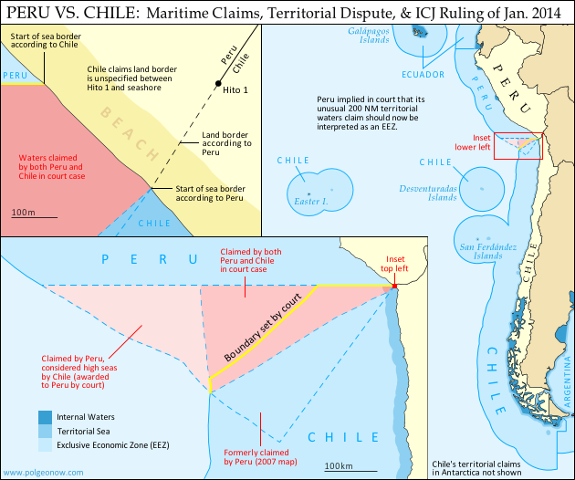
Map by Evan Centanni (country coastlines and land borders from Natural Earth)

Premium members click here to view this article in the ad-free members area. Not a member yet? Subscribe now!

Article by Evan Centanni


Disputed Territory
Chile and Peru have just settled a decades-long dispute over the location of their maritime boundary (the border between their sea zones). A large wedge of sea off the countries’ coast was claimed by both sides, in part because of its high value for the fishing industry. In 2008, Peru took Chile to court over the dispute. Their disagreements would be resolved by the International Court of Justice (ICJ), a United Nations body in the Hague founded for the purpose of settling differences between U.N. member countries.

Peruvian and Chilean Waters
The international Law of the Sea entitles every coastal state to extend its territory out to 12 nautical miles (NM) from the shore, making these “territorial waters” fully part of the country but requiring that foreign ship traffic be allowed to pass through. The law also allows the country to regulate economic activity out to a distance of 200 NM, within what is called an “exclusive economic zone” (EEZ). Lakes, rivers, and bays (as well as coastal areas hemmed in by islands) are known as “internal waters,” where the country has absolute authority just like on its land territory.

Flag of PeruCountry Name:  
• Peru (English)
• Perú (Spanish)
• Piruw (Quechua, Aymara)
Official Name:  
• Republic of Peru (English)
• República del Perú (Spanish)
Piruw Ripuwlika (Quechua)
Piruw Suyu (Aymara)
Capital: Lima

As a country with an unusually long coastline and possession of several offshore islands, Chile has a long strip of territorial waters and a huge EEZ. But Peru is a bit of a special case: it never ratified the U.N. Convention on the Law of the Sea (UNCLOS), and instead of an EEZ proper, it claims something called a “maritime domain” out to a distance of 200 NM.

Because the Peruvian constitution claims “sovereignty” over this domain, it has always been interpreted as equivalent to other countries’ 12 NM territorial waters. However, during the court case against Chile, Peru’s government declared that its declaration of the maritime domain “is applied in a manner consistent with the maritime zones” in the UNCLOS.* This implies that Peru’s “maritime domain” is now to be considered equivalent to an EEZ rather than to territorial waters, thus curtailing any potential accusations of clearly excessive territorial claims by Peru.

*Source: ICJ judgement, p.61

The Dispute
Since the dispute began some decades ago, Chile claimed that the boundary between the two countries extended due west from the end of the land border. To Chile this meant that it could it extend its own EEZ out to 200 NM directly west from its northernmost coast, but also that the line would keep going from there, cutting off any part of Peru’s maritime domain that might wrap around the outside of Chile’s (the Chilean government noted that Chile itself had made a similar concession on its sea border with Argentina). This is not one of the recommended ways of drawing a boundary under the UNCLOS, but that would all be moot if, as Chile claimed, the two countries had already agreed to it by treaty.

Peru felt differently. It argued that the treaties cited by Chile never explicitly specified a border, and that it therefore was still entitled to negotiate one from scratch. Because Peru’s coast is oriented at an angle to Chile’s, drawing a straight line west would give Chile quite a bit of sea that was actually closer to Peru. So in an official government map from 2007, Peru instead showed the boundary running southwest at an angle of more than 50 degrees from Chile’s line.

In court however, Peru made a more modest claim, choosing an “equidistant line” as recommended in the UNCLOS. This meant carefully calculating a path for which every point would be exactly the same distance from the closest parts of the respective Peruvian and Chilean coasts. The result was a not-quite-straight line running southwest at an angle of about 30 degrees from Chile’s border claim. The area between these two lines would become the officially defined disputed zone. Another large area west of this chunk was within 200 NM of Peru’s coast, but beyond 200 NM from Chile. This zone was claimed by Peru but considered by Chile to be neutral “high seas” (a.k.a. international waters).

But where do the lines start?
In fact, Chile and Peru were not even able to agree on exactly where the maritime boundary should start. The land border between the two countries had been agreed upon in the 1929 Treaty of Lima, and precisely marked on the ground with actual physical pillars. However, the last of the pillars was not right on the shore. Known as Hito 1 (Spanish for “Marker 1”), it was placed on dry land a bit inward from the beach, to ensure that it wouldn’t be washed away.

Peru argued that the border continued, in principle, in a slight curve southwest from Hito 1, following the same circular arc that was used to place the last several border pillars. The treaty apparently wasn’t drafted with this extreme degree of accuracy in mind, and was worded in a way that suggested Hito 1 and the shoreline were the same thing. Chile used this to argue that the sea boundary should be measured along a line drawn from the pillar itself (but not starting until the line reached the seashore), and not from a point to the southwest as Peru claimed. This was taken by many to mean that Chile claimed a land border continuing west from the pillar, but in court Chile’s lawyers argued that there simply was no legally defined land boundary beyond Hito 1.

Flag of ChileCountry Name:  
• Chile (English, Spanish)
Official Name:  
• Republic of Chile (English)
• República de Chile (Spanish)
Capital: Santiago

The Judgement
After years of waiting and over a year of deliberation, the court finally released its ruling on January 27, 2014. Media headlines declared the judgement a “win” for Peru, but in fact it was a complex compromise arrived at through a step-by-step examination of each country’s claims.

The Starting Point and Land Border
The court first needed to decide where the maritime boundary should start. Although Peru argued that it was impossible for a land border to just end without reaching the coastline, the court found that before the dispute began, the two countries had consistently used Hito 1 to define where their respective waters met. This was a small win for Chile, meaning that the maritime boundaary must indeed be drawn from the marker itself rather than from the end of an arc as claimed by Peru.

However, defining the land border itself was not on the court’s agenda, so the disagreement over its course technically remains standing. The court noted that the land border does not necessarily have to end at the same place the sea border begins, meaning that Peru’s claimed land border extension could still be valid even now that it’s irrelevant to the course of the sea boundary.

The Course of the Sea Border
To examine the history of Peru and Chile’s claims, the court examined a series of declarations and treaties published by the two countries in the 1940s and 1950s. It found that both countries had indeed declared jurisdiction out to 200 NM, but that they initially didn’t have any particular border in mind. Instead, their early declarations were intended to protect their waters from foreign whaling and other exploitation, not from each other.

With each treaty they increasingly implied that there was a border running straight west from the coast, but never seemed to say it explicitly. It seemed that perhaps an informal agreement had been made and never put on paper. However, the last treaty referred clearly enough to a straight-west boundary that the court decided it was a done deal. The maritime boundary between Chile and Peru would be line running straight west from Hito 1 – a win for Chile.

But wait – it wasn’t as simple as that. Although the court agreed that Chile and Peru had fixed their straight-west border by treaty, it argued that they had never intended for it to run all the way out to 200 NM or beyond. The agreements referring to the border were only concerned with defining where local fishing boats were allowed to cast their nets, and back then these small boats wouldn’t have ventured out past about 80 NM. The court’s decision, then, was that the boundary should run straight west only to a point 80 NM from the shore – beyond that, there was no line legally agreed upon by treaty.

Beyond 80 NM, the court ruled that Peru indeed had the right to a boundary calculated from an equidistant line out to the farthest point within 200 NM of both countries’ coasts. But since this line started from the end of the 80 NM straight-west line, it ended up quite a bit farther north from Peru’s claimed boundary, giving Chile nearly half of the disputed zone. However, it was still seen as a substantial victory for Peru, since Chile had been seen as controlling the entire zone up until then.

The court also ruled that Peru was indeed entitled to any area of sea within 200 NM of its own coast but beyond 200 NM from Chile. This means that the area previously considered high seas by Chile will indeed become part of Peru’s maritime domain, and even after drawing the equidistant line, a bit of this zone still wraps around the outside of Chile’s EEZ, adding one more segment to the maritime boundary between the two countries.

Dispute Resolved
Though the course of the land border may remain a small sticking point, the sea dispute between Peru and Chile has now been settled (that is, unless the countries argue over the exact coordinates of the line, which were not explicitly named by the court). The ICJ’s ruling is binding, and both Chile and Peru have agreed to respect the court’s decision. Peru’s president Ollanta Humala said he was “pleased” with the ruling, and that he would act quickly to ensure its implementation. President Michelle Bachelet of Chile, on the other hand, called it a “painfull loss,” even while promising to “gradually” implement it.

Full Text: ICJ Judgement of 27 January 2014 – Maritime Dispute (Peru v. Chile)

Related: Map of the Falkland Islands’ Disputed Seas (Argentina vs. U.K.)

Graphics of the Peruvian flag (source) and the Chilean flag (source) are in the public domain.

Sochi 2014: Which Countries Are (and Aren’t) in the Olympics?

This is an older version of our Parade of Nations article. Click here to see the newest edition!

[This article was first published in July 2012 as “Parade of Nations: Which Countries Are (and Aren’t) in the Olympics?“, in connection with that year’s Summer Olympics in London. The following article is an updated version for the 2014 Sochi Winter games.]

World map showing the five continental associations of National Olympic Committees, including all nations eligible for the Olympic games
The five continental associations representing the world’s Olympic Nations. Gold: Pan-American Sports Organization; Green: European Olympic Committees; Black: Olympic Council of Asia; Red: Oceania National Olympic Committees; Blue: Association of National Olympic Committees of Africa; Gray: non-member country or territory. Map by Evan Centanni, starting from this blank map and modeled after this Wikipedia map.

Premium members click here to view this article in the ad-free members area. Not a member yet? Subscribe now!

The 2014 Winter Olympics in Sochi, Russia officially begin tonight (Feb. 7), and it wouldn’t be an Olympic opening ceremony without the Parade of Nations. But how many countries are there in the games, and is everyone included? Read on for an exclusive guide to the roster of Olympic Nations….

How many countries participate in the Olympics?
There are currently 204 recognized Olympic Nations, represented by a National Olympic Committee (NOC) in each country. The games are presided over by the International Olympic Committee (IOC), and the NOCs are divided among five continental associations (see map above). [1]

If 204 countries sounds like too many, don’t worry, you’re not going crazy. Indeed, the U.N. only recognizes 195 sovereign states in the world (See: How Many Countries Are There in the World?). So what gives? Well, it turns out that the IOC has historically been more lax than the U.N. about the criteria for nationhood. Before 1995, some dependent territories were allowed to qualify for the Olympics, and were allowed to stay even after the rules changed. Today, there are ten such territories with Olympic Nation status:

World map marking dependent territories and partially recognized sovereign states which have recognized National Olympic Committees and are allowed by the IOC to participate in the Olympic Games
Click to enlarge: Dependent territories and partially recognized sovereign states admitted to the Olympics. By Evan Centanni, from public domain base map (source).

Americas
 Aruba (Netherlands)
 Bermuda (U.K.)
 British Virgin Islands (U.K.)
 Cayman Islands (U.K.)
 Puerto Rico (U.S.)
 Virgin Islands (U.S.)

Asia
 Hong Kong (China)

Oceania
 American Samoa (U.S.)
 Guam (U.S.)
 Cook Islands (New Zealand)

Besides those exceptions, qualifying as a nation usually requires recognition as a sovereign state by the U.N. Nevertheless, in 1995 disputed Palestine was admitted for the sake of athletes in Gaza and the West Bank, the two semi-autonomous Palestinian Territories which are largely cut off from the main territory of Israel (this was long before Palestine’s recognition as a U.N. observer state). Meanwhile Taiwan, which is claimed by China but effectively ruled as an independent country, has also been allowed to participate – but only on the condition that it calls itself “Chinese Taipei”. [2]

Changes to the roster
Six years ago at the 2008 Summer Olympics in Beijing, there were three new Olympic Nations: the Marshall Islands, Montenegro, and Tuvalu. But since then, no new countries have joined.

A controversy erupted last year when the Russian Olympic Committee listed unrecognized breakaway states South Ossetia and Abkhazia as nations in its database, but the IOC quickly chimed in to remind everyone that it was irrelevant. Russia recognizes the independence of these two states, which seceded from Georgia decades ago and were contested again in a 2008 war, but neither has an internationally recognized Olympic committee.

India, though a long-time member of the IOC, was suspended in December 2012 over problems with the election process in its national committee. The issue was not quite resolved in time for the 2014 games, so India’s three qualifying winter olympians will be participating independently under the Olympic flag. [Update Feb. 16: India’s membership has now been reinstated, and its athletes may compete and walk in the closing ceremony under the Indian flag.]

Which countries aren’t included in the Olympics?
Despite the inclusive and worldwide mission of the Olympic Games, not all of the world’s states are represented. In fact, two U.N.-recognized countries still haven’t joined: South Sudan apparently still hasn’t formed an NOC since gaining independence in 2011, and U.N. observer state Vatican City, the independent Catholic Church headquarters in Rome, has never applied.

The ten dependent territories allowed to participate in the Olympics are only a select few, leaving most of the world’s overseas dependencies without their own teams (though athletes from the territories may attempt to qualify for their patron countries’ teams). Meanwhile, partially recognized or unrecognized states are not usually admitted either, even if they are effectively independent. In fact, there are a number of National Olympic Committees which have been created locally but not recognized by the IOC. Here’s a partial list:

World map marking sovereign states and dependent territories which do not have IOC-recognized National Olympic Committees, and are thus not allowed to send their own teams to the Olympics
Click to enlarge: Territories and sovereign states not represented in the Olympics. Light Blue: No NOC; Dark Blue: NOC not recognized by IOC. Also shown in dark blue outlines: subnational regions with unrecognized NOCs. By Evan Centanni, from public domain map (source).

Africa
 Somaliland (unrecognized sovereign state)

Americas
 Anguilla (U.K. territory)
 Montserrat (U.K. territory)
 Turks & Caicos (U.K. territory)

Asia
 Iraqi Kurdistan (autonomous region in Iraq)
 Macau (Special Administrative Region of China) [3]

Europe
 Abkhazia (partially recognized sovereign state)
 Catalonia (region of Spain)
 Gibraltar (U.K. territory)
 Kosovo (partially recognized sovereign state)
 Northern Cyprus (partially recognized sovereign state)

Oceania
 French Polynesia (French territory)
 New Caledonia (French territory)
 Niue (free associate state of New Zealand)
 Northern Mariana Islands (U.S. territory)

Which countries are attending the Sochi 2014 Winter Olympics?
Unlike the Summer Olympics, which all qualified countries attended two years ago, it’s normal that a lot of countries skip the Winter Olympics. Not surprisingly, most of the absentees are tropical countries where there are fewer chances to practice winter sports. However, there are some exceptions (see map below).

This year there will be a total of 88 nations participating in the Olympics – a record high for the Winter games. [Update Feb. 16: There are now 89 participating nations – check out the updated map.] Wikipedia has a full list of the participating nations, complete with links to the athlete rosters for each national team. Notably, there are seven nations participating in the Winter Olympics for the first time ever this year:

Map of countries with teams attending the 2014 Winter Olympics in Sochi, Russia, including seven countries making their Winter Olympics debut (highlighted).
Click to enlarge: Nations attending the Sochi 2014 Winter Olympics in green; first time Winter Olympics attendees in bright green; ineligible countries/territories in gray. By Evan Centanni, from public domain base map. [Click here for an updated version of this map.]

Africa
 Togo
 Zimbabwe

Americas
 Dominica
 Paraguay 

Asia
 Timor-Leste (East Timor)

Europe
 Malta

Oceania
 Tonga

More Info: 2014 Parade of Nations – ordered list of countries and flagbearers (Wikipedia)

Footnotes

[1] The five associations correspond closely to conventional definitions of the continents, but with a few quirks: Turkey, the Caucasus, and Israel are part of the European association despite being geographically in Asia; and the South American territory of French Guiana also falls under European jurisdiction, because it is considered an integral part of France and does not have a separate team.

[2] “Chinese Taipei” is intended to be ambiguous, since most Taiwanese people consider themselves to be at least culturally Chinese. However, the use of “Taipei” is somewhat unfortunate for the two-thirds of Taiwan’s people who do not live in or near Taipei City. This was especially awkward when the 2009 World Games (an Olympics-connected event) were held in Kaohsiung, Taiwan – something of a rival city to Taipei. 

[3] Although Macau’s NOC is not recognized by the IOC itself, it has in fact been accepted as a member of the relevant continental organization, the Olympic Council of Asia. Macau has participated in the Paralympic Games but not in the regular Olympics.

Syria Civil War Map: January 28, 2014 (#12.1) (Premium)

There are newer versions of this map available. To see them, view all Syria updates.

Map of fighting and territorial control in Syria's Civil War (Free Syrian Army rebels, Kurdish groups, Al-Nusra Front, ISIS/ISIL and others), updated to January 28, 2014. Includes recent locations of conflict between ISIS and other rebel groups, including Raqqa, Jarabulus, Manbij, Kafranbel, and others.

Download PDF
buy

(Subscribe via Paypal)

PolGeoNow presents our first premium Syria map, part of our new more frequent updates for the Syrian Civil War! Since last month a major struggle has emerged between ISIS extremists and a coalition of other rebel groups, with several key towns changing hands. See the updated map and briefing in this premium report. Buy now (US$5.99).

Members click here to proceed to article and map

NOT A MEMBER YET? SUBSCRIBE HERE!

ICYMI: Cape Verde’s Name Change

In the following weeks, PolGeoNow will be publishing several short “in case you missed it (ICYMI)” articles on events from 2013. This is news that we weren’t able to cover when it first broke, but that we thought our readers might still want to know about.

Premium members click here to view this article in the ad-free members area. Not a member yet? Subscribe now!

Topographic map of Cape Verde, now known officially as Cabo Verde
Cape Verde, now officially Cabo Verde (click to enlarge). Map by Oona Räisänen/Wikimedia (CC BY-SA) (source).

By Evan Centanni

Cape Verde Changes Official Name
If you read our article on the year 2013 in political geography changes, you’ve already heard about the change to Cape Verde’s official English name. But since keeping track of country name changes is one of the primary missions of Political Geography Now, we are now presenting this in-depth report on the topic.

On October 25, 2013, this West African island country changed its official English name at the U.N., from “Cape Verde” to “Cabo Verde”. Unlike other recent country name changes, like those of Libya or Hungary, Cape Verde is changing its short-form official name as well as the long-form one. The long name has also been changed, from “Republic of Cape Verde” to “Republic of Cabo Verde”.

Location on the globe of Cape Verde, now known officially as Cabo Verde
Location of Cabo Verde. Graphic slightly modified from this map by Eddo/Wikimedia (CC BY-SA).

Language Issues
In fact, in its own official language of Portuguese the country has always been known as Cabo Verde, meaning “green cape”. But curiously, partially translated “Cape Verde” has long been the established English name. Perhaps to avoid the inconvenience of juggling these slightly different appellations, the country’s government has now requested to be known only by the fully Portuguese version. It is also promoting a name change in French, from “le Cap-Vert” to just “Cabo Verde”.

How Do You Say That?
The traditional English name of the country, Cape Verde, is pronounced “kayp verd”. On the other hand, the new name is presumably intended to be pronounced as closely as possible to the Portuguese: approximately “kah-bo vehr-dih” (the “e” at the end is pronounced something like an English “short i”). Our bet is that common English usage will default to either “vehr-day” or “vehr-dee”.

What’s in a Name Change?

Flag of Cabo Verde (Cape Verde)Country Name:  
• Cabo Verde (Portugues, official English)
• Cape Verde (traditional English)
Full Name:  
• Republic of Cabo Verde (English)
• República de Cabo Verde (Portugues)
Capital: Praia
Demonym: Cape Verdean (traditional), Cabo Verdean (official)

Ultimately no country’s government can control what people call it in another language, and it’s always been normal for them to be called very different names by speakers of foreign tongues. Think of how Deutschland and Italia are known as “Germany” and “Italy” in English – it would be very difficult to convince all English speakers to switch to the native names. And every language does this. For some, such as Chinese or Arabic, every country’s name is at least a bit different from its native appellation, due to the needs of transliterating from Latin letters into the language’s native script.

What Cape Verde’s change will affect is official usage in the United Nations, and diplomats will also be obliged to use the new name in official English communications. Meanwhile, the international standard list of country codes, ISO 3166-1, is based on U.N. usage, meaning that “Cabo Verde” will soon begin appearing on country lists online and elsewhere (though the change hasn’t come through quite yet).

Some organizations, like National Geographic, which already favors using native names whenever possible, will also oblige the Cape Verdean government in their publications. However, the majority of news media and average people may be reluctant to make the switch, as has been the case with Ivory Coast and East Timor.

Graphic of the flag of Cape Verde (Cabo Verde) is in the public domain (source).

South Sudan Rebellion: Map Update 2 (Premium Content)

Map of rebel control in South Sudan's ongoing rebellion, updated to Jan. 16, 2014

Download PDF
buy

(Subscribe via Paypal)

Both peace talks and fighting continue nearly two weeks after our last South Sudan update. In the meantime, there have been several changes to rebel control. The newly updated premium map and report reflect those events, as well as newly available information about other localities. Buy now (US$2.99).

Premium article includes:

  • Exclusive updated map of rebel control in South Sudan’s ongoing uprising (current as of January 16, 2014)
  • A number of new localities have been added to the map since last time
  • Report chronicling changes to territorial control since the previous map, with links to sources

Members click here to proceed to article and map

Not a member yet? Subscribe Now!

Iraq: Map of Al Qaeda Control

There are newer versions of this map available. To see them, view all Iraq updates.

PolGeoNow presents our first map of Iraq, showing control by the government and Al Qaeda rebels in the country’s ongoing crisis. Areas of autonomous Kurdish administration in the north are also indicated.

Want to see timely updates for this map? Subscribe to our premium member service!

Map of territorial control in Iraq in January 2014, including cities and countryside held by Al Qaeda (ISIS) as well as areas administered by Kurdistan
Territorial control in Iraq at the beginning of 2014. Map by Evan Centanni, starting from this blank map by German Wikipedia user NordNordWest. License: CC BY-SA

Premium members click here to view this article in the ad-free members area. Not a member yet? Subscribe now!

By Evan Centanni

Al Qaeda in Iraq
Though the reality is of course more complex, power politics in Iraq often revolve around the country’s three largest ethnic groups: Shia (Shiite) Arabs, Sunni Arabs, and Kurds (most Kurds are religiously Sunni, but their language and cultural distinguish them from Arabs). Prime Minister Nouri al-Maliki, a Shia Arab, is often accused of manipulating Iraq’s democracy to exclusively serve the country’s Shia majority. The Kurds govern a highly autonomous region in the northeast, but the Sunni Arabs who dominate northwestern Iraq have relatively little political power. Into the fray has jumped Al Qaeda in Iraq, now part of the Islamic State of Iraq and al-Sham (ISIS) organization which also controls parts of Syria (map). Al Qaeda has waged a fierce campaign against the Iraqi government in the name of Sunnis, though the group is still rejected by many of the people it claims to protect.

Past Territorial Control
During the height of the Iraqi insurgency, Al Qaeda controlled large swaths of northern and central Iraq, including areas of the capital, Baghdad. Over the next few years it lost most or all of its territory, but has recently been making a gradual comeback. A map from the Reuters news agency last month shows a surprisingly large number of areas apparently under Al Qaeda’s influence, though scholarly research from the Institute for the Study of War determined just three major areas of control for the group (shown with shading on our map).

Flag of IraqCountry Name:  
• Iraq (English, Kurdish)
• al-‘Irāq (Arabic)
Official Name:  
• Republic of Iraq (English)
• Jumhūriyyat al-‘Irāq (Arabic)
Komara Iraqê (Kurdish)
Capital: Baghdad

Cities Captured
Things changed early this month, when a botched government crackdown resulted in Al Qaeda fighters taking control of the two largest cities in the western province of Anbar. It started when Prime Minister Maliki ordered the army to clear a one-year-old camp of Sunni protesters in the city of Ramadi, which he claimed Al Qaeda was using as a base.

After clashes with enraged local militias, Maliki agreed to withdraw the army. But soon after he did so, Al Qaeda launched a large-scale attack on Ramadi and nearby Fallujah. The army returned, and a three-way struggle ensued between government forces, Al Qaeda, and local militias who supported neither. On January 3, Al Qaeda fighters of ISIS declared Fallujah an independent Islamic state, and both Fullujah and Ramadi were reportedly under partial control of the militants. By the next day, they were said to be in nearly full control of Fallujah, as well as the nearby town of Karma.

ISIS also apparently captured several other towns along the Euphrates River, but a few – including Hit, Habbaniyah, and the Husaybah border crossing with Syria – were quickly retaken by the Iraqi army. Still, to control Anbar’s two major cities is to dominate the province as a whole. And although government forces have been making steady progress in retaking Ramadi, at least 10% of the city is reportedly still under Al Qaeda control. Fallujah still remains in rebel hands, though some local leaders claim that power is held by local militias rather than the ISIS/Al Qaeda fighters.

Graphic of the Iraqi flag is in the public domain (source).

South Sudan: Rebel Control Map Update (Premium Content)

There are newer versions of this map available. To see the full list of updates, view all South Sudan articles

Map of rebel control in South Sudan's 2013-2014 political crisis, updated to Jan. 3, 2014

Download PDF
buy

(Subscribe via Paypal)

Since our first map report on rebel control in South Sudan’s political crisis, the situation has continued to develop quickly, with several cities and towns changing hands. PolGeoNow now presents an updated map and report exclusively available as premium content for purchase and to our subscribers. Buy now for only US$2.99!

Premium article includes:

  • Exclusive updated map of rebel control in South Sudan’s ongoing uprising 
  • Report chronicling changes since the previous map, with links to sources

Members click here to proceed to article and map

Not a member yet? Subscribe Now!

2013: The Year in Political Geography Changes

By Evan Centanni

Premium members click here to view this article in the ad-free members area. Not a member yet? Subscribe now!

 Although popular for maps of territorial control in conflict zones, PolGeoNow’s original mission is tracking formal changes to the world’s political geography. When new countries appear, borders change, and territorial disputes arise or are settled, you’ll hear about it here. As 2013 draws to a close, here’s our look back at the major events of the year:

Map of the Palestinian Territories, now known in the official standard as
“State of Palestine”

Country Name Changes
This year didn’t see the creation of any new countries (unless you count the failed bid of the Bangsamoro Republik), but there were a few changes to country names. In October, the African island country of Cape Verde chose to change its official English name to “Cabo Verde”, with the long form being “Republic of Cabo Verde”. This brings it in line with the name in Portuguese, the country’s official language. Meanwhile, in January, Libya established its full name as “State of Libya,” after more than a year of going without an official long-form name. Since the 2011 revolution, the new government had been calling the country anything but Muammar Gaddafi’s preferred “Great Socialist People’s Libyan Arab Jamahiriya”.

This year the international ISO standard for country names also made two updates based on changes that actually happened in 2012: Somalia became “Federal Republic of Somalia” after its Transitional Federal Government was replaced by a permanent one, and “the Occupied Palestinian Territory” became “the State of Palestine” to reflect official U.N. usage after Palestine was upgraded to country status by the organization’s General Assembly.

Map of the European Union, new member Croatia, and prospective future member countries
Croatia joins the European Union

See also:
All articles on country name changes 
Is Palestine Really a Country?
Somalia: The Retreat of Al Shabaab

Intergovernmental Organizations
Though the membership roster of the ever-conspicuous United Nations didn’t change this year, and the world’s more obscure intergovernmental organizations are too many to keep up with, there were some changes to the member lists of prominent world bodies. Perhaps most notably, Croatia joined the European Union (and left CEFTA), and both Laos and Tajikistan became members of the World Trade Organization.

Map of the Bolivarian Alliance for the Americas (ALBA), including new member Saint Lucia
Saint Lucia joins ALBA

Also in 2013:

See also:  All intergovernmental organization articles

Map of all countries that recognize the Republic of Kosovo as independent
Countries recognizing Kosovo

Diplomatic Recognition
The world’s partially recognized countries continued to struggle for international validation in 2013. Kosovo proved most active with eight new recognitions, bringing its total to 53% of all U.N. members. Meanwhile, Palestine has the most total recognitions for a country not in the U.N., gaining two and revealing one more in 2013 for a total of 69%. On the other hand, late in the year Taiwan lost recognition from the Gambia, bringing its number of diplomatic allies down to just 22 (11% of U.N. members).

In the messy foreign relations of Western Sahara, Haiti “withdrew” its prior recognition of the disputed state (though there are arguments this is legally invalid), while Barbados, Saint Vincent and the Grenadines, and Panama “froze” their relations. However, Honduras re-initiated its relationship with Western Sahara after allegedly withdrawing recognition in 2000. Meanwhile, South Sudan, the world’s newest country, established diplomatic relations with Benin this year, though since it’s an uncontroversial member of the U.N., all the world’s countries are already assumed  to recognize it by default.

Map of the former territorial dispute between Niger and Burkina Faso, resolved in a 2013 ruling of the International Criminal Court
Border dispute resolved

See also: All articles about diplomatic recognition

Disputed Territories
Many – probably most – of the world’s countries maintain territorial disputes with their neighbors, disagreeing over borders or claiming key regions as their own. But this year saw the resolution of two such disputes, one over the course of the border between Niger and Burkina Faso, and the other over the land surrounding Preah Vihear temple between Thailand and Cambodia.

Meanwhile, small disputes sprung up on the Guinea-Côte d’Ivoire border and between India and Myanmar, though neither has developed into a high-level international spat. Conversely, another new claim was probably all bark and no bite: upset over an existing dispute, Nicaraguan president Daniel Ortega threatened in August to “recover” an entire province of Costa Rica.

Map of the territorial seas and exclusive economic zone (EEZ) of the Falkland/Malvinas Islands disputed between the U.K. and Argentina
Seas of the Falkland Islands

No major disputed territories seem to have traded hands violently this year, but there have been some power shifts nonetheless. Though the dispute was legally resolved years ago, Nigeria only just this summer finished transferring the Bakassi Peninsula to Cameroon’s control. Meanwhile, the northern region of Kosovo, whose local government considers it part of Serbia, saw a change in status as Kosovo agreed to grant it partial autonomy. And in the hotly disputed South China Sea, China consolidated its control over the Filipino-claimed Scarborough Shoal, while also laying siege to another shoal occupied by the Philippines.

Map of the Senkaku/Diaoyu Islands, disputed between Japan and China
The Senkaku/Diaoyu Islands

However, the two highest-profile disputes this year were probably the Senkaku/Diaoyu Islands in the East China Sea and the Falkland/Malvinas Islands in the South Atlantic, though neither experienced any real change of status. The Senkaku/Diaoyus have been the scene of escalating brinkmanship between China and Japan, while the Falklands incurred the wrath of Argentina when they voted by a margin of 99.8% to remain a U.K. territory. This year PolGeoNow published a map of the Falklands’ disputed seas, a map and feature on the Senkaku/Diaoyus, and a photo-illustrated dossier on the latter group’s eight different islands.

See also: All articles on disputed territories 

Air and Seas
Though neglected by most maps, maritime and airspace claims are very important to modern international relations. No changes to claims of territorial waters and exclusive economic zones (EEZs) came to our attention this year, though Somalia did reassert a claim to extensive territorial waters in contravention of a previous agreement with Kenya, and the U.S. signed a treaty with Kiribati ironing out sea borders in the Pacific. On the other hand, control over resources on the seabed beyond EEZ limits continued to be a hot topic, with Russia, Nicaragua, Micronesia, Denmark, Angola, and Canada all filing full or partial claims with the a U.N. commission this year.

Map of the dispute between North Korea and South Korea over their maritime boundary
Korea’s sea border dispute

Somalia also made news about its airspace in 2013, final taking possession of its own skies from a U.N. caretaker body that had administered them since 1994. Breakaway state Somaliland, however, objected to Somalia’s federal government taking over the entire region’s airspace, asserting control over its own portion and refusing to let federal government aircraft land in the territory. However, the dispute was eventually resolved, with Somalia and Somaliland establishing a joint committee for air traffic control in the region.

See also: All articles on maritime borders and jurisdiction

Happy new year, and keep coming back to PolGeoNow for more changes to geography in 2014!

    South Sudan Crisis: Rebel Control Map (Premium Content)

    There are newer versions of this map available. To see the full list of updates, view all South Sudan articles

    Report and map of rebel control in South Sudan's December 2013 political crisis; includes indications of control by state and city, including Juba, Bor, Bentiu, Malakal, and more

    Download PDF
    buy

    After a sudden outbreak of political violence last week, the military of South Sudan has fragmented into two competing factions, with rebellious defectors capturing a large swath of the world’s newest country. PolGeoNow now presents the first map of rebel control in South Sudan’s ongoing crisis, an exclusive for premium subscribers and purchasers.

    Premium article includes:

    • Exclusive, up-to-date map of rebel control by state and city in South Sudan’s ongoing uprising
    • Outline of the course of events so far, including the captures of three state capitals by rebel forces
    • Brief description of the causes and humanitarian consequences of the current conflict

    Members click here to proceed to article and map

    Not a member yet? Subscribe Now!