How Many Countries Are There in the World in January 2016?

There are newer editions of this article available. To find the most recent, view all “How Many Countries in the World” updates!

This article was first published in 2011, and the version below was last updated in January 2016 for South Sudan’s admission as an Olympic Nation

How many countries in the world?
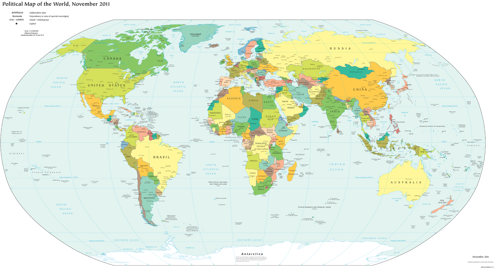
A world political map published by the U.S. government (public domain)

One of the most basic questions for map-lovers is, “How many countries are there in the world?” But anyone who replies with a simple number is leaving out part of the story. The fact is, the answer depends heavily on how you define “country”.

Here are six of the most common answers, each correct in its own way:

195 Sovereign States According to the UN
“Country” and “nation” are casual words for what political scientists call a “sovereign state”, meaning a place with its own borders and completely independent government. The question of which places count as sovereign states can be controversial, but for starters we can count all the member and observer countries of the United Nations (UN):

UN Members: 193
UN Observer States: 2
Total: 195

These countries mostly all accept each other as sovereign states, and they’re the ones you’ll see on most world maps and many lists of the world’s countries. Most of the countries you’ve ever heard of are probably members of the UN, and the two UN Observer States are Vatican City (represented by the Holy See) and Palestine. If you want to know the names of all 195, Wikipedia has a complete list.

The last addition to the list was in 2012, when Palestine became a UN Observer State, and the last country to join the UN as a full member was South Sudan in 2011.

Note: Palestine’s status as a UN Observer State is controversial, so some lists may still only include 194 countries.

201 States With At Least Partial Recognition
Several more country candidates are left out of the UN itself, but are still officially acknowledged by at least one UN member (this kind of official acceptance is called “diplomatic recognition“). These controversial countries are usually labeled on world maps as disputed territories or special situations, if they’re on the map at all.
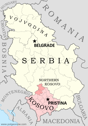
Map of Serbia, Kosovo, and North Kosovo
Kosovo is claimed by Serbia, but recognized as independent by over 100 countries.

UN Members: 193
UN Observer States: 2
States With Partial Recognition:
Total: 201

The six non-UN states with partial recognition are Taiwan, Western Sahara, Kosovo, South Ossetia, Abkhazia, and Northern Cyprus. All of these are claimed as parts of other countries, but aren’t actually controlled by them (at least not completely). The number of UN members recognizing them varies, from just one for Northern Cyprus to over 100 for Kosovo.

A few lists also include the Cook Islands and Niue as partially-recognized states. These two places sometimes act like independent countries, but they’ve never actually declared independence or tried to join the UN, and are usually considered overseas territories of New Zealand.

204-207 De Facto Sovereign States
But wait, there’s more! Those six partially recognized countries aren’t the only breakaway states with full self-governance. There are at least three more declared countries that aren’t recognized by any UN members at all, but still operate independently from the countries that claim them. These are often called “de facto” sovereign states, a fancy Latin way of saying that they’re independent countries in actual fact, even if not on paper.

UN Members: 193
UN Observer States: 2
States With Partial Recognition:
Unrecognized de facto Sovereign States: 3 to 6 (see below)
Total: 204 to 207

The three places most often considered de facto independent countries are Nagorno-Karabakh, Transnistria, and Somaliland. And since 2014 there are three more contenders for the list: the Islamic State, the Donetsk People’s Republic, and the Lugansk People’s Republic. But because these last three are located in active war zones and have only limited government structures, there’s some debate over whether they count even as de facto countries.

Tiny “micronations” declared by individual people are usually not taken seriously enough to count on the list. The closest contender would be Sealand, but it’s debatable whether this tiny “nation” really counts as having a territory, population, or government, all key ingredients for a sovereign state.

There are also many rebel-held territories (and fully self-governing areas like Puntland) that aren’t controlled by any country, but are left off the list because they aren’t trying to become independent countries. They agree in principle to be part of the country they’re in, even though they might disagree about who should be in charge or how the country should be governed.

206 Olympic Nations
Lots of people learn about the world’s list of countries by watching the Olympic Games every two years. If you’re one of them, you might be confused at why the Olympic Parade of Nations claims over 200 members, even though your atlas only has 195.

This is because the Olympics didn’t always require applicants to be independent countries. Dependent territories with partial self-government have sometimes been approved by the International Olympic Committee (IOC), and a couple of the partially-recognized states mentioned above have also managed this.

Olympic Nations that are UN Member States: 193
Olympic Nations that are UN Observer States: 1
Olympic Nations that are Partially-recognized States: 2
Olympic Nations that are Dependent Territories: 10
Total IOC-Recognized Olympic Nations: 206
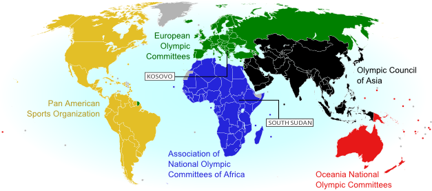
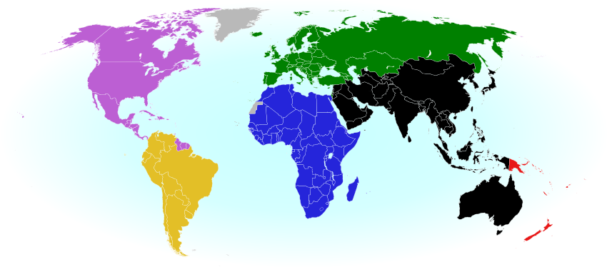
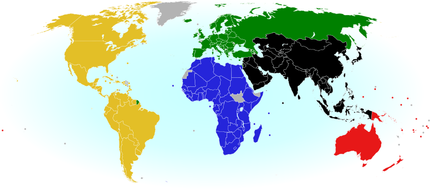
World map showing the five continental associations of National Olympic Committees, including all nations eligible for the Olympic games
The Olympics include most of the world’s independent countries, and some dependent territories too.

About half of the dependent territories in the Olympics are overseas possessions of the US (such as Puerto Rico) and of the UK (such as Bermuda), and some nearly-independent “countries” such as the Cook Islands (New Zealand) and Aruba (the Netherlands) are included as well.

Every UN member country is also in the Olympics, with the latest addition, South Sudan, joining in August 2015.  The one UN Observer State in the Olympics is Palestine; Vatican City isn’t interested. As for the two partially-recognized IOC members, Kosovo just became an Olympic Nation in 2014, and Taiwan has been a member for some time, but has to call itself  “Chinese Taipei” after a deal struck with China in the 1980s.

See Also: Parade of Nations: Which Countries Are (and Aren’t) in the Olympics

209 FIFA Countries Eligible for the World Cup
Soccer, or football as it’s known outside North America, is the world’s most popular sport, and most international matches all the way up to the World Cup are regulated by an organization called FIFA. If you’re a soccer superfan, you might know there are 209 member countries that compete in FIFA matches (though most don’t make it to the World Cup). This is even more than the number of Olympic Nations, and certainly more than the number of independent countries on most world maps.

Like the Olympics, FIFA didn’t always require independence or international recognition of its member states. Now it’s a bit stricter, but any team that’s already a member is allowed to stay. And based on European tradition, FIFA allows England, Scotland, Wales, and Northern Ireland to compete as separate teams, even though they’re all part of the UK.
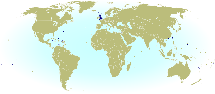
World map marking dependent territories, partially recognized sovereign states, and subnational entities that have national football (soccer) teams recognized by FIFA, making them eligible for the World Cup.
Map of FIFA members that aren’t recognized as independent countries by the U.N.

Teams of UN Member States: 186
Teams of UN Observer States: 1
Teams of Partially Recognized States: 1
Teams of UK Constituent Countries: 4
Teams of Dependent Territories: 17
Total FIFA Member Associations: 209

You may notice that not all of the 193 UN member states are included. That’s because several very small countries aren’t members, plus the UK is replaced by its four “constituent countries”, which aren’t UN members on their own.

See Also: Which Countries Are (and Aren’t) Part of FIFA?

249 Country Codes in the ISO Standard List
Have you ever been filling out an internet form, and had to choose from a surprisingly long list of countries? You were probably looking at the international standard “country code” list, officially known as ISO 3166-1. Many companies and other organizations adopt this standard list rather than spending their own time compiling one. The standard also includes convenient two-letter codes for each country, like us for the United States, de for Germany, and jp for Japan, which you might recognize from web addresses specific to those countries.

This ISO standard is based on an official list kept by the UN….but then why on Earth are there 249 country codes? That’s way more than the total number of UN member and observer countries! Well, the standard list does leave out some breakaway states not recognized by the UN, but makes up for it by listing dependent territories separately from their mother countries. So there are country codes not only for actual countries, but also for nearly-independent states, overseas territories, uninhabited islands, and even Antarctica! This is important because organizations might need an option for every place that any person is located, and dependent territories often aren’t technically part of the countries they belong to.

UN Members: 193
UN Observer States: 2
States With Partial Recognition:
Inhabited Dependent Territories: 45
Uninhabited Territories: 6
Antarctica: 1
Total: 249

So there you have it! Next time someone tells you “There are X countries in the world,” remember that the real answer isn’t so simple!
2014: The Year in Political Geography Changes

Premium members click here to view this article in the ad-free members area. Not a member yet? Subscribe now!

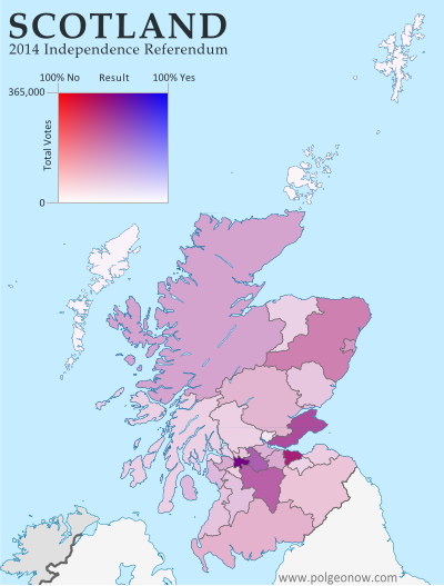
Map of voting results in Scotland's 2014 independence referendum, modified to show the effects of population differences between Scotland's regions
Scotland said “NO” to independence in a close vote last September.

Inside this Review of 2014:

  • New countries & breakaway states
  • Membership in international organizations
  • Recognition of disputed countries
  • Territorial disputes
  • Rebel control
  • Sea borders and seabed claims
  • New states and provinces
  • Changes to world time zones
  • And more!

PolGeoNow’s mission is tracking changes to the world’s countries, borders, and territories, whether it’s happening formally on the books or unofficially on the ground. When new countries appear, borders change, and territorial disputes arise or are settled, you’ll hear about it here. With 2014 now concluded, here’s our look back at the major events of the year!

(Note: For extra coverage of political geography events in 2015, follow us on Twitter!)

Declarations of Independence: New Countries in 2014?
Scotland passed up its chance to become the year’s only fully-recognized new country, but 2014 saw no shortage of attempts at independence. Catalonia held a non-binding vote on separation from Spain, and separatists in Venice conducted a large-scale online poll on leaving Italy, but both were symbolic attempts that saw little participation from opponents.

See Also: What would have happened if Scotland voted to leave the UK?

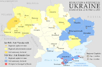
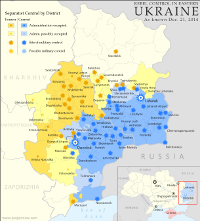
Map of rebel control in Ukraine, showing the areas claimed by the breakaway Donetsk and Lugansk People's Republics.
Actual territorial control of the “Donetsk People’s Republic” and “Lugansk People’s Republic”

The most successful declaration of independence in 2014 was that of Crimea, where rebels and Russian troops overthrew the local administration and declared independence from Ukraine. Official diplomatic recognition from Russia lent this “Republic of Crimea” a brief boost in official status, putting it roughly on par with established breakaway Northern Cyprus (which is recognized only by Turkey, and came about in a similar manner 40 years ago). However, Crimea’s new administration claimed sovereignty for less than a week before voluntarily merging into Russia.

See Also: Was Crimea Really a Country?

The Ukraine conflict has also seen the emergence of two more aspiring countries, the Donetsk People’s Republic and Lugansk People’s Republic, sometimes unified as “Novorossiya“. Neither is recognized by any other country (except fellow breakaway South Ossetia), but extensive territorial control lends their claims a degree of fact, if not official diplomatic status.

Map of territorial control in Iraq by the Islamic State and Kurdish Peshmerga, as of August 2014.
The “Islamic State” took over much of northern Iraq in 2014.

Not to be forgotten is the so-called “Islamic State“, declared in June by the extremist rebels formerly known as the “Islamic State of Iraq and al-Sham” (ISIS or ISIL). The group began seizing full control of populated territories in late 2013, and by the end of 2014 they controlled an enormous chunk of former Syria and Iraq. Claiming to be the modern “caliphate” (empire of all Muslims), the Islamic State is in some sense an independent country of its own, despite fierce objections from the international community and many of its own would-be “citizens”.

Rebels in Nigeria and Libya attempted to piggyback on the Islamic State’s success by speaking of “caliphates” and “emirates” (small kingdoms), but it remains to be seen how serious they are about formal independence. Meanwhile, a rebel independence claim in the Central African Republic fizzled out after the group’s own leadership declined to endorse it. Though each serious in its own way, Greenpeace’s declaration of a “Glacier Republic” in Chile, a U.S. man’s quest to make his daughter a North African princess, and several symbolic independence declarations by Australian aboriginal peoples were all ignored completely in diplomatic circles.

See all articles on newly declared countries

Country Name & Flag Changes
Unlike in 2013, no existing countries seem to have changed their official names last year. Nor have any flag changes come to our attention, though it often takes some time for small flag modifications to reach our ears.

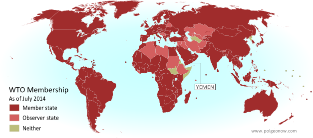
Map of World Trade Organization (WTO) member and observer countries, updated for July 2014 to include new member Yemen
The World Trade Organization got a new member in 2014.

Intergovernmental Organizations
The year 2014 saw many changes to membership in intergovernmental organizations, with these being the most prominent events:

See all intergovernmental organization articles

Diplomatic Recognition
Other than Crimea (see above), several of the world’s other partially recognized countries also saw changes in recognition in 2014.

Map of countries that recognize Kosovo as independent, updated for 2014.
Kosovo is now recognized by every country in Oceania.

Kosovo still led the pack in diplomatic recognitions, with four more countries recognizing it as independent from Serbia, though that’s down 50% from the eight recognitions it received in 2013. Palestine only received one diplomatic recognition (down from two in 2013), but it was an important one: European Union member Sweden.

Western Sahara saw no net change in its number of active recognitions, with Mauritius “withdrawing” recognition and Paraguay’s recognition “suspended“, but Kenya and Malawi apparently resuming theirs. Withdrawing or suspending recognition is a legal gray area, since recognition of a country (as opposed to a particular government of that country) is usually considered irrevocable. However, Tuvalu did something similar in 2014 as well, backpedaling on its 2011 recognition of Abkhazia and South Ossetia (both of which claim independence from Georgia).


See all articles about diplomatic recognition

Map of the so-called Republic of Crimea, which briefly declared independence in 2014 before merging into Russia.
Crimea is now disputed between Ukraine and Russia.

Disputed Territories on Land
The biggest change to the world’s territorial disputes in 2014 was the creation of a major new disputed territory: Crimea. This region was universally recognized as part of Ukraine at the beginning of the year, but after a swift military campaign in March, it’s now a territory administered by Russia and claimed by Ukraine.

In addition to Crimea, Russian president Vladimir Putin hinted at another new territorial dispute, suggesting that all of eastern and southern Ukraine, which he referred to by the historical term “Novorossiya” (“New Russia”), should really be part of his own country. Elsewhere, local disputes arose during the process of marking out the border between Nigeria and Cameroon, while Iraq and Iran agreed to put to rest a border dispute over the Shatt al-Arab river mouth.

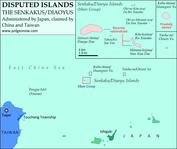
Map of the Senkaku/Diaoyu Islands, disputed between Japan and China
The Senkaku/Diaoyu Islands

Beyond Crimea, China dominated the list of high-tension disputes in 2014, facing off with Vietnamese and Philippine forces in the South China Sea, and sending troops into an area disputed with India, but joining with Japan in a cooling of 2013’s heated jockeying over the Senkaku/Diaoyu islands. India, however, saw even greater border strife in the long-disputed Kashmir region, which saw the worst fighting in a decade between Indian and Pakistani forces.

Another notable development affected one of the world’s more unique territorial disputes: landlocked Bolivia’s assertion that Chile owes it land with a coastline – any land with a coastline (Bolivia claims no specific rightful border). In 2014, Bolivia took Chile to the International Court of Justice over the claim, and Chile appears to be cooperating, feeling that the facts are heavily in its favor. However, the verdict could take years to arrive.

See all articles on disputed territories

Territorial Control

Map of Boko Haram rebel control in Nigeria in 2014.
Boko Haram now controls parts of Nigeria.

As mentioned above in “Declarations of Independence”, 2014 saw the seizure of major areas of Ukraine, Iraq, and Syria by rebel groups. Beyond those three cases, the next most-reported was perhaps Nigeria, where Boko Haram rebels made a spectacular resurgence after having lost territory they briefly controlled in 2013. The group now controls more territory than ever before, and is having a degree of success holding it against the Nigerian government.

Though less heard-about, what happened to Libya in 2014 was in some ways even more dramatic. Although the government had only kept tenuous control of the country since the revolution in 2011, with local militias providing security in most places, last year the country fell apart in earnest. By the end of 2014, the militias had aligned into several opposing coalitions, with the internationally-recognized government exiled from the capital in Tripoli to a smaller city near the border with Egypt. (Coming Soon: Stay tuned to PolGeoNow for an all new map of territorial control in Libya!)

Map of rebel control in South Sudan's civil war as of February 2014
South Sudan spent 2014 split by civil war.

South Sudan also saw a major increase in rebel control, as the civil war that began in late 2013 reached its peak a couple months later. Meanwhile, Yemen‘s Houthi rebels, who have administered the country’s far northwest for years, advanced as far as the national capital of Sanaa. Separatists in northern Mali also claimed to recapture some towns in 2014, but negotiations are ongoing, and there was no repeat of their major takeover in 2012. Conflicts in the divided countries of Somalia, Sudan, the Democratic Republic of the Congo, and the Central African Republic dragged on into 2014, with major areas of each remaining under rebel control, while a similar situation prevailed in Myanmar (Burma).

There were major events in the claimed State of Palestine during the past year as well, with the West Bank and Gaza Strip nominally reunited in a peace deal between rival political parties Fatah and Hamas, but parts of the Gaza Strip temporarily re-occupied by Israel during a war between Hamas and that country. Overflow from the year’s major conflicts also saw small-scale seizures of territory in Lebanon by Syrian rebels, and in Cameroon by Boko Haram rebels from Nigeria. It was less clear whether activity by rebels in Mozambique and anti-cartel vigilantes in Mexico constituted real territorial control.

See all articles on countries with divided territorial control

Sea Borders and Claims
Jurisdiction over much of the world’s oceans is still unresolved, with neighboring countries often disagreeing on where the lines fall between their respective waters, which include both territorial seas (a thin strip along the coast) and exclusive economic zones (EEZ; a much wider band where they have economic control but not full ownership). However, 2014 was a relatively big year for settling these maritime boundaries.

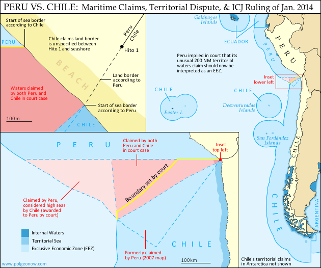
Map of Chile and Peru's territorial waters and exclusive economic zones (EEZ), plus the details of their territorial dispute at sea and disagreement over the land border. Shows the results of the Jan. 27, 2014 ruling by the International Court of Justice (ICJ) settling the dispute.
Peru and Chile’s maritime dispute was settled in court.

In January, a long-standing dispute between Chile and Peru was resolved by an International Court of Justice (ICJ) ruling, in a partial compromise that largely favored Peru (in-depth map and report). A similar dispute between India and Bangladesh was settled at the Permanent Court of Arbitration in July, with the ruling mostly favoring Bangladesh.

Meanwhile, a number of countries signed treaties to resolve their own sea border issues. Germany and the Netherlands agreed to jointly govern a long-disputed bay,  Lithuania settled its final undefined sea border with Sweden, and the Philippines and Indonesia drew the line through a once-disputed area of sea between their respective islands. The Netherlands also signed a boundary treaty with Caribbean island country St. Kitts and Nevis (which lies close to the Dutch island of Sint Eustatius), and long-overdue boundary treaties were signed by Ecuador and Costa Rica (see map below) as well as Russia and Estonia.

Map of Ecuador and Peru's territorial seas as claimed in 2011, showing neighboring countries' territorial seas and exclusive economic zones.
Ecuador and Costa Rica’s outlying islands share a maritime boundary (2012 map)

International law allows countries to claim rights to resources on the “continental shelf” well beyond the 200 nautical mile limit of their EEZs, and many countries were still in the process of doing so in 2014. Toward the end of the year, Greenland and its patron country Denmark made news by formally claiming a large area of seabed under the North Pole, in what will likely lead into a dispute between several arctic countries. Formal continental shelf claims were also filed by the Bahamas, Tonga, and Somalia, while Spain and France submitted claims connected to their outlying islands in the Atlantic.

The West African countries of Cabo Verde, The Gambia, Guinea, Guinea-Bissau, Mauritania, Senegal, and Sierra Leone made a single joint submission of their claim to the UN, defining the seven countries’ collective continental shelf without saying where the lines between each country’s piece would be drawn. The UN commission that administers continental shelf claims stamped its final approval on a 2009 claim by Ghana and partial claims by Russia and Denmark.

See all articles on maritime borders and jurisdiction

Provinces & States
Though creating a new U.S. state is a major legislative ordeal, some countries’ provinces and other divisions are created, redrawn, or abolished at will. The many changes to the world’s administrative subdivisions can be hard to keep track of, but luckily we have the wonderful Statoids website to help with that.

In 2014, Crimea took the spotlight for subdivision changes as well as other political geography categories, with rebels declaring the region independent from Ukraine, then with Russia creating two new subdivisions to accommodate Crimea’s merger with that country. But India also made news with the creation of a new state, Telangana, while Panama, Egypt, Mauritania, and Montenegro all created new provinces or equivalent divisions. Bahrain also eliminated one of its provinces, while the nearly-independent Kurdistan created a new province within Iraq.

Time Zones

Map of political divisions in Ukraine in early 2014, including Euromaidan occupations as well as the later wave of anti-maidan occupations that would lead to the civil war.
In Ukraine’s 2014 political strife, not even the clocks were safe.

The past year also saw some changes to the world’s time zones. After controversially joining Russia, Crimea switched from Eastern European Time to Moscow Standard Time, setting clocks two hours forward to account for its simultaneous time zone switch and exit from daylight savings time (DST). Not long afterwards, Russia overhauled its whole time zone system, returning to its pre-2011 system of 11 zones (from 2011 to 2014 there were only nine zones) and changing the practice of seasonal time changes. Eastern Ukraine’s self-declared Donetsk and Lugansk People’s Republics also followed suit with Crimea, though their change (like Crimea’s) may not be recognized by the Ukrainian government.

Papua New Guinea also added a new time zone, with its eastern island of Bougainville jumping forward an hour to sync with neighboring Solomon Islands. The British Caribbean territory of Turks and Caicos decided to stay permanently in daylight savings time from 2014 onward, and Egypt reinstated DST after a three-year break, but with a temporary suspension during the Muslim holiday of Ramadan. Meanwhile, a number of countries adjusted their dates for the annual beginning and ending of DST.

What major political geography events will happen in 2015?
Stay tuned to PolGeoNow for quality maps and reporting! Also, don’t forget to follow us on Twitter for extra reporting on world events, and add us on Facebook or Tumblr to get updates when new articles are published!

    World Cup 2014: Which Countries Are (and Aren’t) Members of FIFA?

    Watching the 2018 World Cup? Check out our updated edition of this article!
     

    World map showing the six continental confederations of national association football (soccer) teams, including all teams eligible for the World Cup
    The six continental confederations of national football teams associated with FIFA. Not all confederation members are individually members of FIFA. Map by Evan Centanni, based on work by EOZyo (source).

    Football/soccer fans around the world are tuning in tonight for the beginning of the month-long FIFA World Cup in Brazil. But how much do you know about which teams can compete? Which countries were eligible to enter the tournament, and which are excluded? Read on for an exclusive guide to the roster of FIFA national football teams…

    Premium members click here to view this article in the ad-free members area. Not a member yet? Subscribe now!

    How many countries participate in FIFA?
    There are currently 209 national football teams with official FIFA membership, which is required to compete for qualification in the World Cup. FIFA members are divided into six continental confederations that preside over competitions within each region (see map above).*

    You might have noticed that 209 is more than the number of actual independent countries in the world. After all, the United Nations only recognizes 195. That’s because, much like the Olympics, FIFA used to allow dependent territories to apply for membership. Now they only admit recognized independent countries (with a few exceptions), but teams that became members in the past are allowed to stay on regardless of their sovereignty status.

    FIFA members that aren’t independent countries
    Today there are 18 dependent territories with FIFA-eligible national football teams:

    World map marking dependent territories, partially recognized sovereign states, and subnational entities which have national football (soccer) teams recognized by FIFA, making them eligible for the World Cup.
    Click to enlarge: FIFA members that aren’t independent countries. By Evan Centanni, from public domain base map (source).

    North America & the Caribbean
     Anguilla (UK)
     Aruba (Netherlands)
     Bermuda (UK)
     British Virgin Islands (UK)
     Cayman Islands (UK)
     Curaçao (Netherlands)
     Montserrat (UK)
     Puerto Rico (US)
     Turks and Caicos Islands (UK)
    U.S. Virgin Islands (US)

    Asia
     Guam (US)*
     Hong Kong (China)
     Macau (China)

    Europe
     Faroe Islands (Denmark)

    Oceania
     American Samoa (US)
     Cook Islands (New Zealand)
     New Caledonia (France)
     Tahiti (France)

    By tradition, each of the four “countries” making up the UK also has a separate team, despite them not being independent themselves:

     England
     Northern Ireland
     Scotland
     Wales

    Also as in the Olympics, disputed states Palestine and Taiwan (known in sports as “Chinese Taipei“) are included as special cases without the requirement for fully-recognized independence. In fact, Palestine is now treated as an independent country by the UN, but that wasn’t yet the case when it was first admitted to FIFA in 1998.

    Changes since 2010
    Since the last World Cup in 2010, one new country has joined FIFA: South Sudan. This East African nation only became independent in 2011, after the 2010 World Cup in South Africa was already over. It’s now fully eligible, but still wasn’t able to enter in this year’s Cup because qualification matches began just before it joined.

    Meanwhile, the Netherlands Antilles were eligible for the last time in 2010, though they didn’t manage to qualify for the World Cup finals. Later that same year, the Dutch dependency was split into several separate territories, and its FIFA membership was inherited only by the largest island, Curaçao, which entered for the 2014 Cup but again didn’t qualify. Two of the other island territories, Bonaire and Sint Maarten, formed their own national teams but have not been accepted as FIFA members. However, they have been allowed to participate in their relevant continental organization, the Confederation of North, Central American and Caribbean Association Football (CONCACAF).

    Which countries aren’t members of FIFA?
    Even though quite a few dependent territories are FIFA members, there are still a few fully independent countries that aren’t eligible:

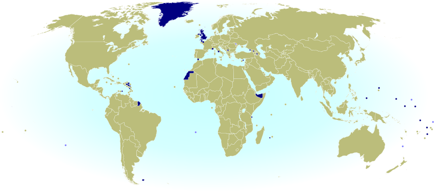
    World map marking countries and dependent territories that aren't members of FIFA, and are thus ineligible to qualify for the World Cup
    Click to enlarge: Countries and territories without FIFA membership. Dark Blue: national team not recognized by FIFA; Light Blue: no known national team. Map by Evan Centanni, from public domain base map (source).

    Europe
      Monaco
     United Kingdom (UK)
       Vatican City

    Oceania
     Kiribati
     Marshall Islands
     Micronesia
     Nauru
     Palau
     Tuvalu

    The Marshall Islands are the only independent, UN-recognized country that don’t have any national team at all. All the others on the list do have teams (yes, even Vatican City!), but are not members of FIFA. This means they’re not eligible even to enter into qualifying matches for the World Cup, though Kiribati and Tuvalu do participate as associate members in the relevant continental organization, the Oceania Football Confederation (OFC).

    Even though Palestine and Taiwan managed to secure membership, other partially unrecognized countries haven’t been able to get into FIFA. There are seven non-FIFA teams belonging to de facto independent countries:

     Abkhazia
     Kosovo
     Nagorno-Karabakh
     Northern Cyprus
     Somaliland
     South Ossetia
     Western Sahara

    Another unrecognized breakaway state, Transnistria, doesn’t have a national team.

    Finally, there are many dependent territories that have never been able to get into FIFA. Of these, eleven territories or country subdivisions have full or associate membership in the continental confederations, but not in FIFA itself:

    Africa
     Réunion (France)
     Zanzibar (Tanzania)

    North America and the Caribbean
     Bonaire (Netherlands)
     French Guiana (France)*
     Guadeloupe (France)
     Martinique (France)
     Saint-Martin (France)
     Sint Maarten (Netherlands)

    Asia
     Northern Mariana Islands (US)*

    Europe
     Gibraltar (UK)

    Oceania
     Niue (New Zealand)

    Which countries qualified for the 2014 FIFA World Cup in Brazil?
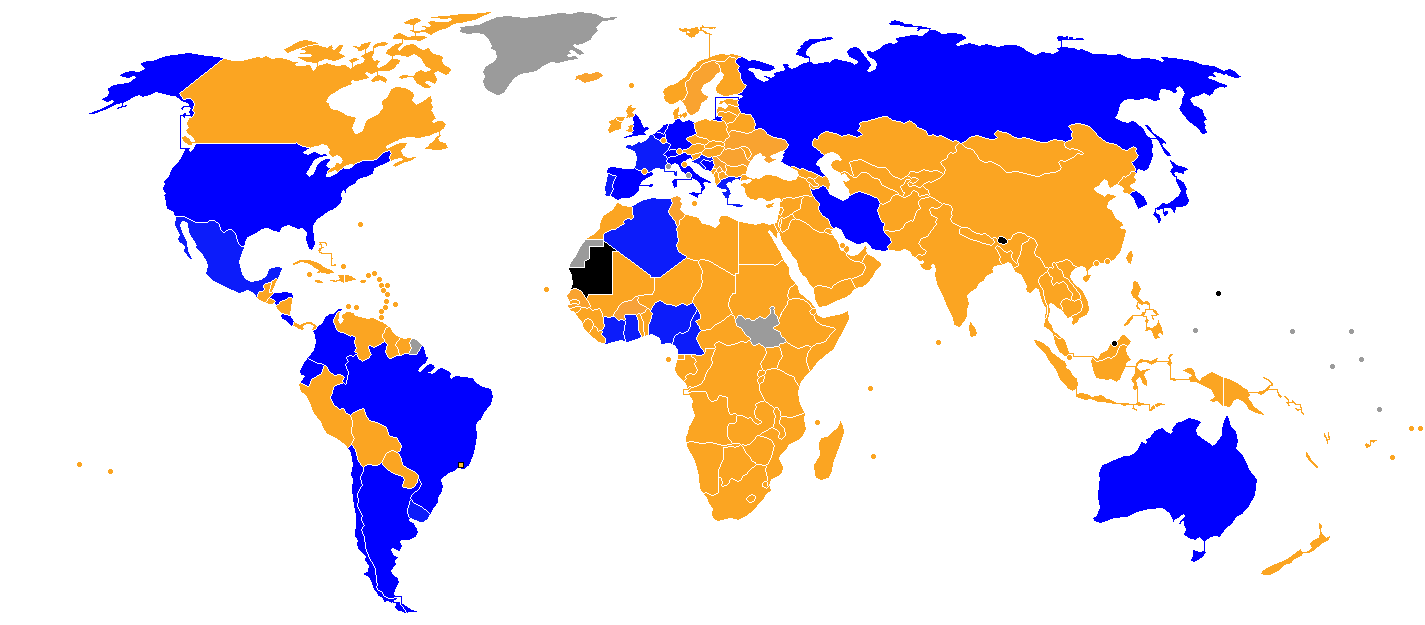
    Even if a country is an eligible FIFA member, it still has to compete in the pre-tournament qualification process before moving on to the actual World Cup. Out of the 208 countries eligible at the time of qualification (remember, South Sudan missed out), there are just 32 countries qualifying for this year’s World Cup finals in Brazil. One of them, Bosnia and Herzegovina, is in the finals for the first time after gaining independence from Yugoslavia in 1992. See below for a full map of eligible and qualifying national teams in this year’s Cup:

    Map of which countries qualified for the 2014 FIFA World Cup in Brazil, as well as which countries were eliminated in the qualifying rounds and which didn't enter at all.
    Blue = countries qualifying for the 2014 FIFA World Cup; orange = countries eliminated in the qualifying rounds; black = countries that didn’t enter; gray = countries that weren’t members when qualification began. Map by Jlsa and IgorMagic (source; CC BY-SA).

    Enjoy the matches!


    Note
    *The six continental football confederations are based on the geographical borders of the world’s continents, but there are some exceptions. The Asian Football Confederation also includes Australia, Guam, and the Northern Mariana Islands (usually considered part of Oceania), while Caribbean countries, including South America’s Guyana, Suriname, and French Guiana, are grouped with North and Central America. As in the Olympics, Israel is a member of the European confederation despite its location on the Asian continent. Turkey, Kazakhstan, Armenia, Azerbaijan, and Georgia are also grouped with Europe but located mostly in Asia.

    Olympics Map Update: Which Countries Are Attending Sochi 2014?

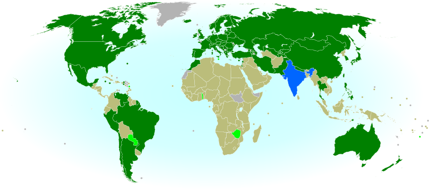
    Map of countries with teams attending the 2014 Winter Olympics in Sochi, Russia, including seven countries making their Winter Olympics debut (highlighted), and one that was suspended but reinstated during the games.
    Sochi 2014: Nations attending the Winter Olympics for the first time in bright green; suspended nations reinstated during the games in blue; all other nations attending Sochi 2014 in dark green; ineligible countries/territories in gray. By Evan Centanni, from public domain base map.

    Premium members click here to view this article in the ad-free members area. Not a member yet? Subscribe now!

    By Evan Centanni

    India’s Olympics Membership Reinstated
    This is a quick update to the map of countries attending the Sochi 2014 Winter Olympics, which originally appeared in Sochi 2014: Which Countries Are (and Aren’t) in the Olympics? That article explained that India was not officially included in this year’s games due its suspension from the International Olympic Committee (IOC) over a voting issue.

    However, on Tuesday India’s IOC membership was reinstated, effective immediately. This means that the three Indian athletes at the games, who were allowed to participate independently under the Olympic flag during the opening ceremony and first few days of the event, may now officially represent India again. This is the first time in history that a country has been un-suspended from the the Olympics during the actual games.

    Sochi 2014: Which Countries Are (and Aren’t) in the Olympics?

    This is an older version of our Parade of Nations article. Click here to see the newest edition!

    [This article was first published in July 2012 as “Parade of Nations: Which Countries Are (and Aren’t) in the Olympics?“, in connection with that year’s Summer Olympics in London. The following article is an updated version for the 2014 Sochi Winter games.]

    World map showing the five continental associations of National Olympic Committees, including all nations eligible for the Olympic games
    The five continental associations representing the world’s Olympic Nations. Gold: Pan-American Sports Organization; Green: European Olympic Committees; Black: Olympic Council of Asia; Red: Oceania National Olympic Committees; Blue: Association of National Olympic Committees of Africa; Gray: non-member country or territory. Map by Evan Centanni, starting from this blank map and modeled after this Wikipedia map.

    Premium members click here to view this article in the ad-free members area. Not a member yet? Subscribe now!

    The 2014 Winter Olympics in Sochi, Russia officially begin tonight (Feb. 7), and it wouldn’t be an Olympic opening ceremony without the Parade of Nations. But how many countries are there in the games, and is everyone included? Read on for an exclusive guide to the roster of Olympic Nations….

    How many countries participate in the Olympics?
    There are currently 204 recognized Olympic Nations, represented by a National Olympic Committee (NOC) in each country. The games are presided over by the International Olympic Committee (IOC), and the NOCs are divided among five continental associations (see map above). [1]

    If 204 countries sounds like too many, don’t worry, you’re not going crazy. Indeed, the U.N. only recognizes 195 sovereign states in the world (See: How Many Countries Are There in the World?). So what gives? Well, it turns out that the IOC has historically been more lax than the U.N. about the criteria for nationhood. Before 1995, some dependent territories were allowed to qualify for the Olympics, and were allowed to stay even after the rules changed. Today, there are ten such territories with Olympic Nation status:

    World map marking dependent territories and partially recognized sovereign states which have recognized National Olympic Committees and are allowed by the IOC to participate in the Olympic Games
    Click to enlarge: Dependent territories and partially recognized sovereign states admitted to the Olympics. By Evan Centanni, from public domain base map (source).

    Americas
     Aruba (Netherlands)
     Bermuda (U.K.)
     British Virgin Islands (U.K.)
     Cayman Islands (U.K.)
     Puerto Rico (U.S.)
     Virgin Islands (U.S.)

    Asia
     Hong Kong (China)

    Oceania
     American Samoa (U.S.)
     Guam (U.S.)
     Cook Islands (New Zealand)

    Besides those exceptions, qualifying as a nation usually requires recognition as a sovereign state by the U.N. Nevertheless, in 1995 disputed Palestine was admitted for the sake of athletes in Gaza and the West Bank, the two semi-autonomous Palestinian Territories which are largely cut off from the main territory of Israel (this was long before Palestine’s recognition as a U.N. observer state). Meanwhile Taiwan, which is claimed by China but effectively ruled as an independent country, has also been allowed to participate – but only on the condition that it calls itself “Chinese Taipei”. [2]

    Changes to the roster
    Six years ago at the 2008 Summer Olympics in Beijing, there were three new Olympic Nations: the Marshall Islands, Montenegro, and Tuvalu. But since then, no new countries have joined.

    A controversy erupted last year when the Russian Olympic Committee listed unrecognized breakaway states South Ossetia and Abkhazia as nations in its database, but the IOC quickly chimed in to remind everyone that it was irrelevant. Russia recognizes the independence of these two states, which seceded from Georgia decades ago and were contested again in a 2008 war, but neither has an internationally recognized Olympic committee.

    India, though a long-time member of the IOC, was suspended in December 2012 over problems with the election process in its national committee. The issue was not quite resolved in time for the 2014 games, so India’s three qualifying winter olympians will be participating independently under the Olympic flag. [Update Feb. 16: India’s membership has now been reinstated, and its athletes may compete and walk in the closing ceremony under the Indian flag.]

    Which countries aren’t included in the Olympics?
    Despite the inclusive and worldwide mission of the Olympic Games, not all of the world’s states are represented. In fact, two U.N.-recognized countries still haven’t joined: South Sudan apparently still hasn’t formed an NOC since gaining independence in 2011, and U.N. observer state Vatican City, the independent Catholic Church headquarters in Rome, has never applied.

    The ten dependent territories allowed to participate in the Olympics are only a select few, leaving most of the world’s overseas dependencies without their own teams (though athletes from the territories may attempt to qualify for their patron countries’ teams). Meanwhile, partially recognized or unrecognized states are not usually admitted either, even if they are effectively independent. In fact, there are a number of National Olympic Committees which have been created locally but not recognized by the IOC. Here’s a partial list:

    World map marking sovereign states and dependent territories which do not have IOC-recognized National Olympic Committees, and are thus not allowed to send their own teams to the Olympics
    Click to enlarge: Territories and sovereign states not represented in the Olympics. Light Blue: No NOC; Dark Blue: NOC not recognized by IOC. Also shown in dark blue outlines: subnational regions with unrecognized NOCs. By Evan Centanni, from public domain map (source).

    Africa
     Somaliland (unrecognized sovereign state)

    Americas
     Anguilla (U.K. territory)
     Montserrat (U.K. territory)
     Turks & Caicos (U.K. territory)

    Asia
     Iraqi Kurdistan (autonomous region in Iraq)
     Macau (Special Administrative Region of China) [3]

    Europe
     Abkhazia (partially recognized sovereign state)
     Catalonia (region of Spain)
     Gibraltar (U.K. territory)
     Kosovo (partially recognized sovereign state)
     Northern Cyprus (partially recognized sovereign state)

    Oceania
     French Polynesia (French territory)
     New Caledonia (French territory)
     Niue (free associate state of New Zealand)
     Northern Mariana Islands (U.S. territory)

    Which countries are attending the Sochi 2014 Winter Olympics?
    Unlike the Summer Olympics, which all qualified countries attended two years ago, it’s normal that a lot of countries skip the Winter Olympics. Not surprisingly, most of the absentees are tropical countries where there are fewer chances to practice winter sports. However, there are some exceptions (see map below).

    This year there will be a total of 88 nations participating in the Olympics – a record high for the Winter games. [Update Feb. 16: There are now 89 participating nations – check out the updated map.] Wikipedia has a full list of the participating nations, complete with links to the athlete rosters for each national team. Notably, there are seven nations participating in the Winter Olympics for the first time ever this year:

    Map of countries with teams attending the 2014 Winter Olympics in Sochi, Russia, including seven countries making their Winter Olympics debut (highlighted).
    Click to enlarge: Nations attending the Sochi 2014 Winter Olympics in green; first time Winter Olympics attendees in bright green; ineligible countries/territories in gray. By Evan Centanni, from public domain base map. [Click here for an updated version of this map.]

    Africa
     Togo
     Zimbabwe

    Americas
     Dominica
     Paraguay 

    Asia
     Timor-Leste (East Timor)

    Europe
     Malta

    Oceania
     Tonga

    More Info: 2014 Parade of Nations – ordered list of countries and flagbearers (Wikipedia)

    Footnotes

    [1] The five associations correspond closely to conventional definitions of the continents, but with a few quirks: Turkey, the Caucasus, and Israel are part of the European association despite being geographically in Asia; and the South American territory of French Guiana also falls under European jurisdiction, because it is considered an integral part of France and does not have a separate team.

    [2] “Chinese Taipei” is intended to be ambiguous, since most Taiwanese people consider themselves to be at least culturally Chinese. However, the use of “Taipei” is somewhat unfortunate for the two-thirds of Taiwan’s people who do not live in or near Taipei City. This was especially awkward when the 2009 World Games (an Olympics-connected event) were held in Kaohsiung, Taiwan – something of a rival city to Taipei. 

    [3] Although Macau’s NOC is not recognized by the IOC itself, it has in fact been accepted as a member of the relevant continental organization, the Olympic Council of Asia. Macau has participated in the Paralympic Games but not in the regular Olympics.

    2013: The Year in Political Geography Changes

    By Evan Centanni

    Premium members click here to view this article in the ad-free members area. Not a member yet? Subscribe now!

     Although popular for maps of territorial control in conflict zones, PolGeoNow’s original mission is tracking formal changes to the world’s political geography. When new countries appear, borders change, and territorial disputes arise or are settled, you’ll hear about it here. As 2013 draws to a close, here’s our look back at the major events of the year:

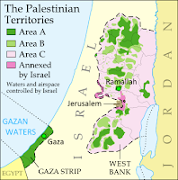
    Map of the Palestinian Territories, now known in the official standard as
    “State of Palestine”

    Country Name Changes
    This year didn’t see the creation of any new countries (unless you count the failed bid of the Bangsamoro Republik), but there were a few changes to country names. In October, the African island country of Cape Verde chose to change its official English name to “Cabo Verde”, with the long form being “Republic of Cabo Verde”. This brings it in line with the name in Portuguese, the country’s official language. Meanwhile, in January, Libya established its full name as “State of Libya,” after more than a year of going without an official long-form name. Since the 2011 revolution, the new government had been calling the country anything but Muammar Gaddafi’s preferred “Great Socialist People’s Libyan Arab Jamahiriya”.

    This year the international ISO standard for country names also made two updates based on changes that actually happened in 2012: Somalia became “Federal Republic of Somalia” after its Transitional Federal Government was replaced by a permanent one, and “the Occupied Palestinian Territory” became “the State of Palestine” to reflect official U.N. usage after Palestine was upgraded to country status by the organization’s General Assembly.

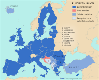
    Map of the European Union, new member Croatia, and prospective future member countries
    Croatia joins the European Union

    See also:
    All articles on country name changes 
    Is Palestine Really a Country?
    Somalia: The Retreat of Al Shabaab

    Intergovernmental Organizations
    Though the membership roster of the ever-conspicuous United Nations didn’t change this year, and the world’s more obscure intergovernmental organizations are too many to keep up with, there were some changes to the member lists of prominent world bodies. Perhaps most notably, Croatia joined the European Union (and left CEFTA), and both Laos and Tajikistan became members of the World Trade Organization.

    Map of the Bolivarian Alliance for the Americas (ALBA), including new member Saint Lucia
    Saint Lucia joins ALBA

    Also in 2013:

    See also:  All intergovernmental organization articles

    Map of all countries that recognize the Republic of Kosovo as independent
    Countries recognizing Kosovo

    Diplomatic Recognition
    The world’s partially recognized countries continued to struggle for international validation in 2013. Kosovo proved most active with eight new recognitions, bringing its total to 53% of all U.N. members. Meanwhile, Palestine has the most total recognitions for a country not in the U.N., gaining two and revealing one more in 2013 for a total of 69%. On the other hand, late in the year Taiwan lost recognition from the Gambia, bringing its number of diplomatic allies down to just 22 (11% of U.N. members).

    In the messy foreign relations of Western Sahara, Haiti “withdrew” its prior recognition of the disputed state (though there are arguments this is legally invalid), while Barbados, Saint Vincent and the Grenadines, and Panama “froze” their relations. However, Honduras re-initiated its relationship with Western Sahara after allegedly withdrawing recognition in 2000. Meanwhile, South Sudan, the world’s newest country, established diplomatic relations with Benin this year, though since it’s an uncontroversial member of the U.N., all the world’s countries are already assumed  to recognize it by default.

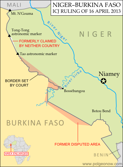
    Map of the former territorial dispute between Niger and Burkina Faso, resolved in a 2013 ruling of the International Criminal Court
    Border dispute resolved

    See also: All articles about diplomatic recognition

    Disputed Territories
    Many – probably most – of the world’s countries maintain territorial disputes with their neighbors, disagreeing over borders or claiming key regions as their own. But this year saw the resolution of two such disputes, one over the course of the border between Niger and Burkina Faso, and the other over the land surrounding Preah Vihear temple between Thailand and Cambodia.

    Meanwhile, small disputes sprung up on the Guinea-Côte d’Ivoire border and between India and Myanmar, though neither has developed into a high-level international spat. Conversely, another new claim was probably all bark and no bite: upset over an existing dispute, Nicaraguan president Daniel Ortega threatened in August to “recover” an entire province of Costa Rica.

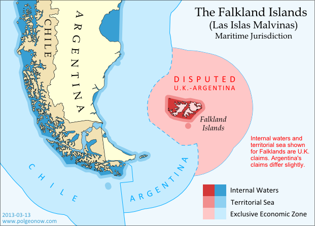
    Map of the territorial seas and exclusive economic zone (EEZ) of the Falkland/Malvinas Islands disputed between the U.K. and Argentina
    Seas of the Falkland Islands

    No major disputed territories seem to have traded hands violently this year, but there have been some power shifts nonetheless. Though the dispute was legally resolved years ago, Nigeria only just this summer finished transferring the Bakassi Peninsula to Cameroon’s control. Meanwhile, the northern region of Kosovo, whose local government considers it part of Serbia, saw a change in status as Kosovo agreed to grant it partial autonomy. And in the hotly disputed South China Sea, China consolidated its control over the Filipino-claimed Scarborough Shoal, while also laying siege to another shoal occupied by the Philippines.

    Map of the Senkaku/Diaoyu Islands, disputed between Japan and China
    The Senkaku/Diaoyu Islands

    However, the two highest-profile disputes this year were probably the Senkaku/Diaoyu Islands in the East China Sea and the Falkland/Malvinas Islands in the South Atlantic, though neither experienced any real change of status. The Senkaku/Diaoyus have been the scene of escalating brinkmanship between China and Japan, while the Falklands incurred the wrath of Argentina when they voted by a margin of 99.8% to remain a U.K. territory. This year PolGeoNow published a map of the Falklands’ disputed seas, a map and feature on the Senkaku/Diaoyus, and a photo-illustrated dossier on the latter group’s eight different islands.

    See also: All articles on disputed territories 

    Air and Seas
    Though neglected by most maps, maritime and airspace claims are very important to modern international relations. No changes to claims of territorial waters and exclusive economic zones (EEZs) came to our attention this year, though Somalia did reassert a claim to extensive territorial waters in contravention of a previous agreement with Kenya, and the U.S. signed a treaty with Kiribati ironing out sea borders in the Pacific. On the other hand, control over resources on the seabed beyond EEZ limits continued to be a hot topic, with Russia, Nicaragua, Micronesia, Denmark, Angola, and Canada all filing full or partial claims with the a U.N. commission this year.

    Map of the dispute between North Korea and South Korea over their maritime boundary
    Korea’s sea border dispute

    Somalia also made news about its airspace in 2013, final taking possession of its own skies from a U.N. caretaker body that had administered them since 1994. Breakaway state Somaliland, however, objected to Somalia’s federal government taking over the entire region’s airspace, asserting control over its own portion and refusing to let federal government aircraft land in the territory. However, the dispute was eventually resolved, with Somalia and Somaliland establishing a joint committee for air traffic control in the region.

    See also: All articles on maritime borders and jurisdiction

    Happy new year, and keep coming back to PolGeoNow for more changes to geography in 2014!

      Lies Your World Map Told You: 5 Ways You’re Being Misled

      Unfortunately, most world political maps aren’t telling you the whole story. The idea that Earth’s land is cleanly divvied up into nation-states – one country for each of the world’s peoples – is more an imaginative ideal than a reality. Read on to learn about five ways your map is lying to you about borders, territories, and even the roster of the world’s countries.

      Map of the world's countries according to the U.S. Central Intelligence Agency
      The lines and coloring on this map are hiding major truths about the world’s countries.
      (Source: U.S. CIA; public domain)

      1) Missing Countries
      When choosing what counts as a country, most world maps go by either the official list from their own country or the member/observer roster from the United Nations. Just one problem: there are about ten countries which have declared and enforced their independence, but aren’t recognized by the U.N. or most of the world’s governments. These states may have close ties to a neighbor country, but most of them aren’t at all controlled by the country they’re supposed to be part of.

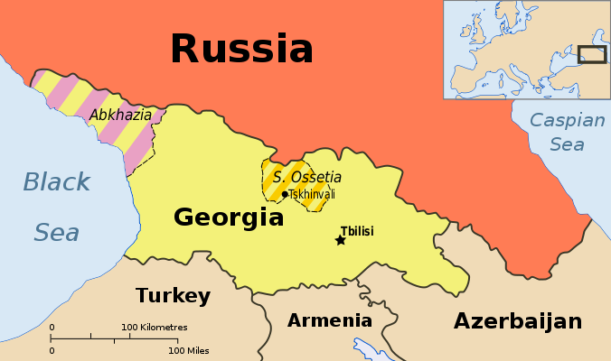
      Map showing Abkhazia and South Ossetia, two breakaway states claimed by Georgia.
      Abkhazia and South Ossetia operate as independent countries, but are claimed by Georgia and only recognized by a few countries. Map by Ssolbergj (CC BY-SA).

      There are some high-profile special cases that warrant at least a note on many maps. Taiwan’s government formally claims to represent non-communist China, though it acts more like a separate country. Palestine, another disputed state, is now recognized as a U.N. observer country despite being forced to share control of its territory with Israel.

      Western Sahara‘s status is considered unresolved by the U.N., and a small piece is effectively independent; meanwhile, Northern Cyprus is recognized only by its patron country, Turkey. The self-proclaimed Republic of Kosovo is now recognized by half of the U.N.’s members but not by the U.N. itself.

      Other countries escape entirely from all but the most careful of political maps, being misleadingly merged into the countries that claim their territories: Abkhazia and South Ossetia into Georgia, Nagorno-Karabakh into Azerbaijan, and Transnistria into Moldova. These four breakaway states are sponsored by neighboring countries, but the most left out of all is Somaliland, which receives no major support or recognition from anyone, despite managing its affairs completely independently from Somalia.

      Unrecognized Countries: More Articles and Maps

      2) Incomplete Control
      Drawing lines around a country on the map might imply that its government controls all the land within those lines. But that’s often not the case in reality. Even setting aside foreign military occupations like the recent U.S. interventions in Iraq and Afghanistan, many countries’ governments don’t control their whole territories. Aside from the cases of breakaway states as described earlier, this mainly occurs in war zones where rebel groups are actively vying for control of all or part of the country.

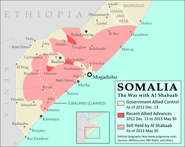
      Map of government and Al Shabaab control in Somalia's ongoing civil war
      Large parts of Somalia are controlled by Al Shabaab extremists. Click for map attribution info (CC BY-SA).

      Somalia is probably the most infamous for this. Its U.N.-recognized government controls around half the country at best, and a few years ago controlled nothing but a part of the capital city! The rest is divided between the religious extremist Al Shabaab and various autonomous states which keep their own counsel on whether to cooperate with the government.

      The territories of Mali, Nigeria, the Central African Republic, Libya, and Ivory Coast have all only recently been reunited (either under the former government or under the rebels), and Syria is the current model of a state falling apart through violence. Other countries with rebels firmly controlling parts of their territory are Yemen, the Democratic Republic of the Congo, and Myanmar/Burma.

      Divided Countries: More Articles and Maps

      3) Undefined Borders

      Map of the border dispute recently resolved between Niger and Burkina Faso
      Niger and Burkina Faso recently resolved an unclear border situation. Map by Evan Centanni (click for details; CC BY-SA).

      Another thing political maps imply is that borders at least have strictly defined locations in principle, even if they’re usually invisible on the ground. If they weren’t well-defined, they wouldn’t all be drawn with solid lines on the map, right? Wrong. Many countries have borders that have never been precisely defined by treaties, a process called “delimitation”.

      Even fewer have been actually “demarcated”, or marked on the ground. In fact, undefined borders are such a big issue among the relatively young countries of Africa that the African Union operates an official border program to encourage the ongoing delimitation of national boundaries.

      The fudge factor in national borders isn’t always big enough to make a difference to where they’re drawn on the world map – but their fuzziness can sometimes have major effects on international relations. An undefined border is a ripe environment for the birth of territorial disputes when neighboring countries have different ideas of where the border should run.

      Sometimes these disputes are only low-level disagreements, such as the one recently resolved between Niger and Burkina Faso; but in other places like the border between Sudan and South Sudan, they can escalate into bloody conflicts.

      Undefined Borders: More Articles and Maps

      4) Disputed Territories
      Your world map may label a few well-known territorial disputes, caused either by vague borders or conflicts over island groups. You might then reasonably conclude that disagreements over who owns a place, though they do happen, are relatively few and far between. Unfortunately, your conclusion would be incorrect. There are far more disputed territories in the world than you’ve probably ever imagined.

      Map of the Senkaku/Diaoyu Islands, controlled by Japan but claimed by China and Taiwan
      Map of the Senkaku/Diaoyu Islands, disputed between Japan, China, and Taiwan (map by Evan Centanni).

      The most bizarre disputes range from high-profile cases, such as the five-way feud over the Spratly Islands, to quieter anomalies like Bir Tawil between Sudan and Egypt, both of whom claim it belongs to the other.

      You may have heard of those, but did you know that (at least on paper) Mongolia is claimed by Taiwan? Or that more than half of Guyana is claimed by Venezuela? What about the several territories disputed between the U.S. and Canada? And those are just the land disputes – wait until you hear about the oceans!

      Disputed Territories: More Articles and Maps

      5) Territorial Seas
      One thing completely left off of most maps is ownership of the sea. The occasional border lines you see across straits on your map are just showing who owns the islands on either side, not who owns the sea in between. The uninterrupted expanse of blue on most maps then might imply that the seas are the domain of no country. This is true for parts of the open ocean far from any coastline – but closer in, countries can and do exercise territorial rights over their neighboring seas. According to international best practices, a country is entitled to extend its territory up to 12 nautical miles (NM) out from its coastline, regulate economic activity out to 200 NM, and sometimes control seafloor oil and mineral exploration out to much further.

      Map of territorial seas and exclusive economic zones (EEZ) around the Falkland Islands (Malvinas), controlled by the U.K. but claimed by Argentina
      Both the land and the seas of the Falkland Islands are disputed between the U.K. and Argentina. Map by Evan Centanni (click for details; CC BY-SA).

      But the divvying up of the world’s seas is still an ongoing process, and there are probably even more maritime disputes than land-based ones. Some countries, like Peru and Ecuador, refuse to recognize the 12 NM limit, claiming sovereign territory out to a full 200 NM. In even more cases, neighboring countries just can’t agree on where to draw the border between their respective territorial seas.

      International law does provide guidance on how to divide it up, but for now many countries make claims far beyond what seems reasonable, apparently hoping they have something extra to give away in future negotiations. The most extreme claims, like China’s infamous “Nine-dotted Line” around most of the South China Sea, don’t seem to follow much legal logic at all.

      Maritime Jurisdiction: More Articles and Maps

      So next time you find yourself looking at a political map of the world, remember to be critical and take those borders with a grain of salt!

      Other Articles You Might Like:
      5 Countries You’ve Never Heard Of (by Their Native Names) 
      How Many Countries Are There in the World?
      Parade of Nations: Which Countries Are (and Aren’t) in the Olympics?
       

      London 2012: Which Countries Are (and Aren’t) in the Olympics?

      This is an older version of our Parade of Nations article. Click here to see the newest edition!

      The 2012 Summer Olympics in London begin tomorrow (July 27), and it wouldn’t be an Olympic opening ceremony without the Parade of Nations. But how many countries are there in the games, and is everyone included? Read on for an exclusive guide to the roster of Olympic Nations….

      World map showing the five continental associations of National Olympic Committees, including all nations eligible for the Olympic games
      The five continental associations representing the world’s Olympic Nations. Gold: Pan-American Sports Organization; Green: European Olympic Committees; Black: Olympic Council of Asia; Red: Oceania National Olympic Committees; Blue: Association of National Olympic Committees of Africa; Gray: non-member country or territory. Map by Evan Centanni, modified from public domain wiki map (source), and modeled after this Wikipedia map.


      How many countries participate in the Olympics?
      There are currently 204 recognized Olympic Nations, represented by a National Olympic Committee (NOC) in each country. The games are presided over by the International Olympic Committee (IOC), and the NOCs are divided among five continental associations (see map above). [1]

      If 204 countries sounds like too many, don’t worry, you’re not going crazy. Indeed, the U.N. only recognizes 194 sovereign states in the world (see also: How Many Countries Are There in the World?). So what gives? Well, it turns out that the IOC has historically been more lax than the U.N. about the criteria for nationhood. Before 1995, some dependent territories were allowed to qualify for the Olympics, and were allowed to stay even after the rules changed. Today, there are ten such territories with Olympic Nation status:

      World map marking dependent territories and partially recognized sovereign states which have recognized National Olympic Committees and are allowed by the IOC to participate in the Olympic Games
      Click to enlarge: Dependent territories and partially recognized sovereign states admitted to the Olympics. By Evan Centanni, from public domain base map (source).

      Americas
       Aruba (Netherlands)
       Bermuda (U.K.)
       British Virgin Islands (U.K.)
       Cayman Islands (U.K.)
       Puerto Rico (U.S.)
       Virgin Islands (U.S.)

      Asia
       Hong Kong (China)

      Oceania
       American Samoa (U.S.)
       Guam (U.S.)
       Cook Islands (New Zealand)

      Besides those exceptions, qualifying as a nation usually requires recognition as a sovereign state by the U.N. However, in 1995 disputed Palestine was admitted for the sake of athletes in Gaza and the West Bank, the two semi-autonomous Palestinian Territories which are largely cut off from the main territory of Israel. And Taiwan, which is claimed by China but effectively ruled as an independent country by the pre-Communist Republic of China government, has also been allowed to participate – but only as long as it refers to itself as “Chinese Taipei”. [2]

      Changes to the roster
      In the last Summer Olympics in Beijing (2008), there were three new Olympic Nations: the Marshall Islands, Montenegro, and Tuvalu. But since then, no new countries have joined. In fact, one has been removed: the Netherlands Antilles, a Dutch dependency in the Caribbean, was ruled ineligible by the IOC last year after the territory was officially dissolved.

      Map marking the location of the former Netherlands Antilles, just prior to the dissolution of the territory
      Location of the former Netherlands Antilles. Public domain map (source).

      Two of the five islands of the Netherlands Antilles are now separate Dutch territories, and the other three islands have joined the Netherlands proper. Since the IOC no longer admits dependent territories, none of the islands can rejoin under their new administrations, but the former territory’s team of three athletes will be allowed to participate independently under the Olympic flag for now. After 2012, they will need to qualify for the Netherlands team in order to join future games.

      Which countries aren’t included in the Olympics?
      Despite the inclusive and worldwide mission of the Olympic Games, not all of the world’s states are represented. In fact, two U.N.-recognized countries still haven’t joined: newly independent South Sudan has not yet formed an NOC, though one of its athletes has been accepted to compete under the Olympic flag this time; and U.N. observer state Vatican City, which perhaps doesn’t consider itself a “nation” (since it serves only as the headquarters of the Catholic Church), has never applied.

      The ten dependent territories allowed to participate in the Olympics are only a select few, leaving most of the world’s overseas dependencies without their own teams (though athletes from the territories may attempt to qualify for their patron country’s team). And partially recognized or unrecognized states are not usually admitted, even if they are effectively independent. In fact, there are a number of National Olympic Committees which have been created locally but not recognized by the IOC:

      World map marking sovereign states and dependent territories which do not have IOC-recognized National Olympic Committees, and are thus not allowed to send their own teams to the Olympics
      Click to enlarge: Territories and sovereign states not represented in the Olympics. Light Blue: No NOC; Dark Blue: NOC not recognized by IOC. Also shown in dark blue outlines: subnational regions with unrecognized NOCs. By Evan Centanni, from public domain map (source).

      Africa
       Somaliland (unrecognized sovereign state)

      Americas
       Anguilla (U.K. territory)
       Montserrat (U.K. territory)
       Turks & Caicos (U.K. territory)

      Asia
       Iraqi Kurdistan (autonomous region in Iraq)
       Macau (Special Administrative Region of China) [3]

      Europe
       Abkhazia (partially recognized sovereign state)
       Catalonia (region of Spain)
       Gibraltar (U.K. territory)
       Kosovo (partially recognized sovereign state)
       Northern Cyprus (partially recognized sovereign state)

      Oceania
       French Polynesia (French territory)
       New Caledonia (French territory)
       Niue (free associate state of New Zealand)
       Northern Mariana Islands (U.S. territory)

      Which countries are attending the London 2012 Olympics?
      It’s not uncommon for a few countries to miss the Olympic Games in a given year – a small country fails to field a team, a big country boycotts, or tropical countries skip the Winter Olympics – but the London 2012 games are special. This year, all 204 recognized Olympic Nations will be attending the games, resulting in one of the biggest international sports events in history. Wikipedia has a full list of the participating nations, complete with links to the rosters for each national team.

      Number of athletes sent to the London 2012 Olympics by each participating country. Map by Foreston/Wikipedia (source). License: CC BY-SA

      Now that you know the background on the Parade of Nations, you can watch the London 2012 opening ceremony and games with a new understanding of the political geography behind the sporting event – if you have any questions, post a comment or shoot me an e-mail!

      Further info: 2012 Parade of Nations – ordered list of countries and flagbearers (Wikipedia)

      Footnotes

      [1] The five associations correspond closely to conventional definitions of the continents, but with a few quirks: Turkey, the Caucasus, and Israel are part of the European association despite being geographically in Asia; and the South American territory of French Guiana also falls under European jurisdiction, because it is considered an integral part of France and does not have a separate team.

      [2] “Chinese Taipei” is intended to be ambiguous, since most Taiwanese people consider themselves to be at least culturally Chinese. However, the use of “Taipei” is somewhat unfortunate for the two-thirds of Taiwan’s people who do not live in or near Taipei City. This was especially awkward when the 2009 World Games (an Olympics-related event) were held in Kaohsiung, Taiwan – something of a rival city to Taipei. 

      [3] Although Macau’s NOC is not recognized by the IOC itself, it has in fact been accepted as a member of the relevant continental organization, the Olympic Council of Asia. Macau has participated in the Paralympic Games but not in the regular Olympics.