Yemen Conflict Map: September 2012 (#4)

Since June, the Yemeni government has completed its campaign to free the south from Al Qaeda rule, but multiple rebel movements remain active. Keep reading for a summary of the current situation. (To see other maps in this series, view all Yemen updates.)

Map of current division in Yemen, including Al Qaeda or Ansar al-Sharia activity, Houthi rebel control, and the location of the Southern Movement insurgency. Update for September 2012.
Presence of rebel forces in Yemen as of September 2012. Ansar al-Sharia is part of Al-Qaeda in the Arabian Peninsula (AQAP). Map by Evan Centanni, using this blank map by NordNordWest/Wikipedia (license: CC BY-SA).

In our previous Yemen map update, we reported on the government’s June 2012 capture of most of Abyan province from Ansar al-Sharia, an armed group associated with Al Qaeda in the Arabian Peninsula (AQAP). After the fall of the militants’ two main “Islamic Emirates” in the towns of Jaar and Zinjibar, the U.S.-backed Yemeni army advanced east into neighboring Shabwah province; after about a week, the Islamists had fled Azzan, their primary stronghold in Shabwah.

At the time, Ansar al-Sharia was also known to control the Shabwah towns of Hawta, Rawdah, and Rudum, yet the militants appear to have since gone underground; Yemen’s government declared victory in the entire region, and no word has since filtered through of Islamist-controlled towns. However, what has become clear is that the extremists have not fled altogether, but are only keeping a lower profile. Reports have even emerged of a major Al Qaeda training camp in Abyan’s Mahfad district
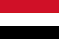
Flag of YemenCountry Name:  
• Yemen (English)
• Al-Yaman (Arabic)
Official Name:  
• Republic of Yemen (English)
al-Jumhūriyyah al-Yamaniyyah (Arabic) 
Capital: Sana’a

Meanwhile, a certain amount of chaos continues in the rest of the country despite the political deal that largely calmed last year’s uprising. In the capital city of Sana’a, the transitional government of President Abd Rabbuh Mansur Al-Hadi faces periodic Al Qaeda terrorist attacks as well as insurrection from soldiers loyal to deposed president Ali Abdullah Saleh, the latter of whom have reportedly taken control of some government buildings.

South of the capital, there is still a simmering separatist insurgency in formerly independent southern Yemen, and in the north a large area is still controlled by the Al Houthi rebels. A Zaidi Shiite rebel group, the Houthis currently maintain an informal truce with the transitional government as they await an overdue national dialogue process. However, they sometimes clash with local militias who resent their territorial encroachment, as well as Salafist fighters, extremist Sunnis who consider the Zaidis to be heretics.  

Graphic of Yemeni flag is in the public domain (source).

Independent Azawad No More: Northern Mali in Islamist Hands

There are newer versions of this map available. To see them, view all Mali maps.   

Since declaring the independence of Azawad in April, control by northern Mali’s MNLA rebels has been usurped by the hardline Islamists of Ansar Dine and MUJAO. The new regime, while still bitter enemies of the Malian government, does not claim independence. Presented here is a map and brief guide explaining the current situation.

Map of Islamist rebel control in northern Mali as of September 2012
Area held by Islamist rebel groups Ansar Dine and MUJWA in northern Mali. Map by Evan Centanni, modified from Wikimedia map by Orionist, using images by Carport and NordNordWest (source). License: CC BY-SA.

Separatists vs. Islamists
Last April, the Tuareg-dominated separatists of the National Movement for the Liberation of Azawad (MNLA) swept into victory in northern Mali, completing their control of the region and declaring independence as the State of Azawad. But their victory was won only with the support of Ansar Dine, an Islamist militia led by veteran Tuareg fighter Iyad Ag Ghaly. The MNLA and Ansar Dine then alternated between cooperation and conflict for months, with the Islamists grabbing ever more control of the region’s cities.

Tensions came to a head on June 26, when a second Islamist group, the Movement for Unity and Jihad in West Africa (MUJWA), violently expelled the MNLA from their capital city of Gao. By month’s end, Ansar Dine had fully pushed the MNLA out of key city Timbuktu, and two weeks later the separatists were driven from their last stronghold in the town of Ansongo. Then just this weekend, MUJWA again made news by seizing the town of Douentza from a formerly cooperative local militia.

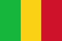
Flag of MaliCountry Name:  
• Mali (English, French, Bambara)
Official Name:  
• Republic of Mali (English)
• République du Mali (French) 
• Mali ka Fasojamana (Bambara)
Capital: Bamako

Though northern Mali is still not controlled by the national government in Bamako, the Islamist militias do not seek independence. Instead, they pursue a vision of strict sharia law throughout Mali. Since these new rulers no longer consider Azawad a sovereign nation, its claim to independence has faded away.

Current Rebel Control
Ansar Dine and MUJWA together appear to hold all of the territory originally seized by the MNLA, with the line of control lying between the towns of Douentza and Sévaré. Bandiagara in the nearby Dogon region may have an army presence, but other towns such as Koro do not, and have seen rebel raids.

Administration is divided between the two Islamist militias, with Ansar Dine apparently controlling regional capitals Timbuktu and Kidal, and MUJWA controlling at least Gao (also a regional capital) and Douentza. Al Qaeda in the Islamic Maghreb (AQIM), a branch of the terrorist group, also maintains a strong presence in northern Mali. MUJWA is historically associated with AQIM, though Ansar Dine’s relationship to the organization is more tenuous.

Special thanks to Peter Tinti (@petertinti), who has provided invaluable commentary throughout the Mali conflict, and has repeatedly pointed me in the right direction in my research.

Note on Names:  
The acronym “MNLA” is based on the French, and is sometimes rendered “NMLA” to match the English. 
MUJWA is also known as “MOJWA” (from an alternate translation) or “MOJAO” (from the French). 
Ansar Dine is pronounced “an-SAR (uhd)-DEEN” and sometimes spelled “Ansar Eddine” or “Ansar ud-Dine”. 
AQIM is also known by its French acronym “AQMI”; its Arabic actually means “Al Qaeda in the Islamic West”.

Graphic of Malian flag is in the public domain (source).
Syrian Uprising Map: August 2012 (#6)

There are newer versions of this map available. To see them, view all Syria updates.

Political Geography Now presents the sixth update to our map of rebel control in Syria’s civil war. Since last month, battle has erupted in the country’s largest city, Kurds have formed a parallel government in northern towns, and more. Read on for a rundown of recent events.

Map of rebel control in Syria's Civil War (Free Syrian Army, Kurdish groups, and others), updated for August 2012
Activity and cities held by rebels and Kurdish groups in Syria, updated August 16, 2012. Map by Evan Centanni, starting from this blank map by German Wikipedia user NordNordWest. License: CC BY-SA

Battles for Damascus & Aleppo
Not long after our last Syria update, the anti-government Free Syrian Army moved into the capital city of Damascus for the first time, taking advantage of the chaos sown by their shocking assassination of the country’s defense minister and two other top security officials. But after claiming control of some neighborhoods for several days, the rebels were eventually driven back into the suburbs.

Yet even as fighters were expelled from Damascus, the Free Syrian Army began moving into Aleppo, Syria’s largest city. By the end of the month, the previously quiet northern metropolis was facing widespread rebel control in “an arc that [covered] eastern and southwestern districts”. Al Bab, one of Aleppo’s two largest satellite cities, also fell to rebel forces at the beginning of August.

Flag of Syria under the current governmentCountry Name:  
• Syria (English)
• Sūriyya/Sūryā (Arabic)
Official Name:  
• Syrian Arab Republic (English)
• al-Jumhūriyyah al-‘Arabīyah  as-Sūriyyah (Arabic)
Capital: Damascus

Rebels Capture Border Crossings
Meanwhile, the armed opposition also launched a takeover of several major crossings along the Syrian border. On the northern boundary between Syria and Turkey, rebels took over Bab Al-Hawa crossing in Idlib province and the Bab Al-Salam and Jarabulus crossings in Aleppo province (“bab” means “gate” in Arabic).

On the eastern border with Iraq, an Iraqi official at one point claimed Syrian rebels controlled all border crossings; however, they later appeared to hold only the Al Bukamal (Abu Kamal) crossing in Deir ez-Zor province.

Kurdish Control in North

Also in July, Kurds in the north began taking control of Kurdish-populated areas. Militias serving the allied Kurdish Democratic Union Party (PYD) and Kurdish National Council (KNC) have so far seized at least nine towns (full list with sources) and parts of Qamishli, as well as two districts of Aleppo city.

These groups’ goal to create a Kurdish autonomous region in the north has alarmed Turkey, which has been fighting Kurdish rebels north of the border for years. So which side of the Syrian civil war are the Kurdish groups on? For now, they oppose the government; but relations with the Arab-dominated Free Syrian Army are tense, and President al-Assad has been accused of intentionally handing over areas to the Kurdish militias in order to keep out Turkey and the other rebels. 

Country in Chaos 

Flag of Syria's Democratic Union Party (PYD), a Kurdish group which now controls many Kurd-populated towns in northern Syria
Flag of the PYD, flown in Kurdish-controlled towns (public domain)

Syria’s northern Idlib province still forms the core of rebel territory (with northern Aleppo province now added), where anti-Assad groups govern most of the countryside and hold major towns such as Saraqeb, Armanaz, and Ariha. However, Deir ez-Zor in the east is also emerging as a power center for the opposition, which now claims to control 90% of the province, including “at least half” of its main city. 

Meanwhile the Syrian National Council (SNC), an opposition umbrella group, has already established unofficial relations with many of the world’s countries, and official diplomatic relations with eight of them. Most of those only acknowledge the SNC as “a legitimate representative” of the Syrian people; but the rebels-turned-leaders of Libya go further, recognizing the Syrian opposition group as the country’s “sole legitimate government”. 

Meanwhile, the Syrian regime has been suspended from the Organization of Islamic Cooperation (OIC), a group including most of the world’s Muslim countries. In the Muslim world, international opposition to al-Assad’s Syrian government has been led by Saudi Arabia (a Sunni-majority country), while support has come mainly from Iran (a Shiite-majority country). Syria’s President Bashar al-Assad belongs to a minority Shiite sect (the Alawites), while the majority of Syrians, including most of the rebels, are Sunnis.

Graphic of Syrian flag is in the public domain (source).

Syrian Uprising: Map Update 5

There are newer versions of this map available. To see them, view all Syria updates.

Political Geography Now presents an updated map of territorial division in Syria, where escalating violence is now referred to by the U.N. as a full-scale civil war. Read on for a rundown of recent events.

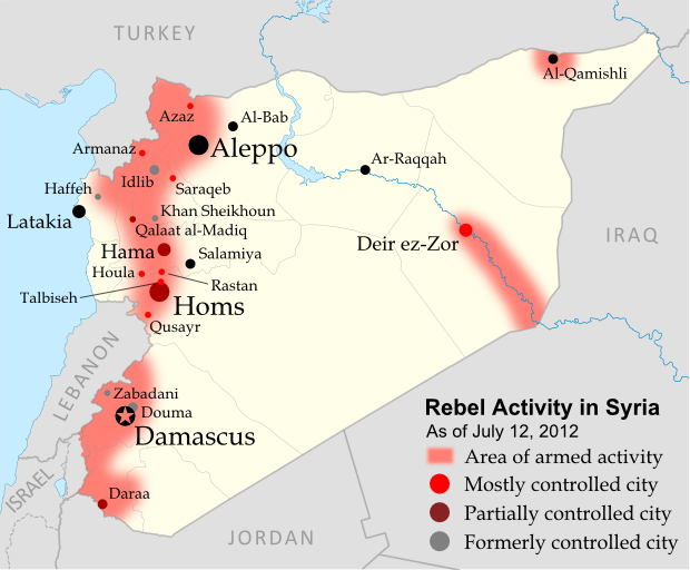
Map of rebel control in Syria's Civil War, updated for July 2012
Activity by rebel groups in Syria, marking areas of armed conflict as well as towns and cities held. Map by Evan Centanni, starting from this blank map by German Wikipedia user NordNordWest. License: CC BY-SA

Syrian Civil War

In the month since our previous Syria report, the Free Syrian Army (FSA), Syria’s main rebel group, has officially abandoned its failed ceasefire with government forces. This nominal change of stance has been presented as a response to continued massacres of Syrian civilians, for which government-supported militias are apparently to blame. Though even the FSA is only a loose organization of rebel cells, other groups have also joined the growing conflict, which the U.N. has begun calling a “civil war“.

Flag of Syria under the current governmentCountry Name:  
• Syria (English)
• Sūriyya/Sūryā (Arabic)
Official Name:  
• Syrian Arab Republic (English)
• al-Jumhūriyyah al-‘Arabīyah  as-Sūriyyah (Arabic)
Capital: Damascus

Rebels Show Strength in North
In the northwest of the country, rebels continue to control much of rural Idlib province, recently capturing the town of Armanaz, and apparently retaking the larger town of Saraqeb (Saraqib). The historical fortress of Qalaat al-Madiq is currently occupied by government forces, but the adjacent town is rebel-controlled.

Furthermore, the long plain extending north from Qalaat al-Madiq nearly to the Turkish border is now reportedly administered by the rebels as something of a parallel state. Areas of the frontier itself have also become a rebel safe haven from air attacks, a result of Turkey’s transfer of weaponry to the border to defend its air space.

Meanwhile, for the first time major rebel activity has spread further westward to Latakia province, where a month ago the insurgents briefly captured the town of Haffeh (Haffah) before withdrawing again. Another defeat came in Khan Sheikhoun, a large town in Idlib province along the government-held Hama-Aleppo road.

Central & Eastern Syria Contested

The central province of Homs has also continued to see heavy fighting, with the FSA capturing the town of Talbiseh and claiming to control all of Qusayr (Quseir), which for months was divided between rebel and Syrian government held areas. In Syria’s capital region, the government has again driven rebels out of the Damascus suburb of Douma. On the other hand, recent reports indicate that opposition forces now control most of Deir ez-Zor (Deir Ezzor), a major city in the country’s far east.

Pre-Baath party flag of Syria, now used as a symbol of opposition in Syria's uprising
Pre-Baath flag of Syria (source)

Opposing Flags
Finally, in an echo of events in Libya last year, opposition protesters in Syria have been flying an older version of the country’s flag, from before President Bashar al-Assad’s Baath party came to power. Based on what happened in Libya, it seems likely this flag could come to serve as the banner of a competing rebel state if the Syrian civil war continues to escalate.

Further Reading: Holliday, Joseph. Syria’s Maturing Insurgency (PDF). Institute for the Study of War (June 2012). 

Graphic of current Syrian flag is in the public domain (source).

Yemen Conflict: Map Update 3

Fighting between Yemen’s transitional government and Al Qaeda branch Ansar al-Sharia reached a climax this week, as government forces captured the militants’ strongholds in Abyan province. This article gives a rundown of recent events and the current situation in divided Yemen.

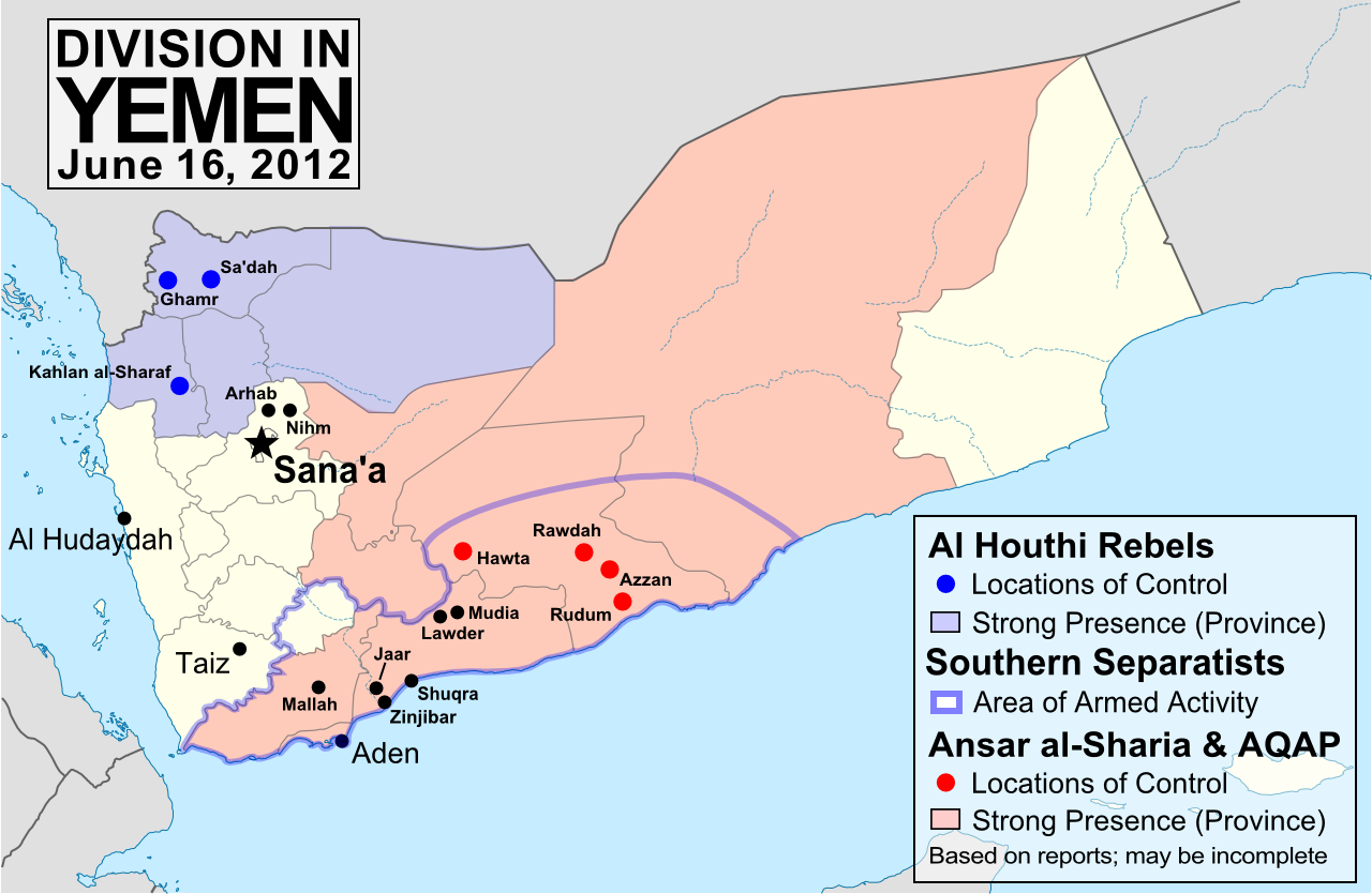
Map of division in Yemen, including control by Al Qaeda or Ansar al-Sharia, the Houthi rebels, and the Southern Movement. Update for June 2012.
Presence of anti-government forces in Yemen in June 2012. Ansar al-Sharia is part of Al-Qaeda in the Arabian Peninsula (AQAP). Map by Evan Centanni, using this blank map by NordNordWest/Wikipedia (license: CC BY-SA).

Note: To see previous Yemen map updates, or to check for new ones, view all Yemen posts on Political Geography Now.

Yemen vs. Al Qaeda

In the three months since our last Yemen update, the national army has been engaged in heavy fighting against Ansar al-Sharia, a front group of Al Qaeda in the Arabian Peninsula (AQAP) which has controlled large areas of Yemen’s south since the chaos of last year’s popular uprising. In some southern towns, Ansar al-Sharia has set up “Islamic Emirates” administered independently of Yemen’s government, with its two most prominent strongholds in Zinjibar and Jaar (renamed “Waqar”).

Flag of Al Qaeda, flown by Ansar al-Sharia in its Islamic emirates in southern Yemen.
Flag flown by Ansar al-Sharia in its emirates – the war banner of Al Qaeda, based on Muhammed’s Black Standard. Public domain graphic by Ingoman (source).

The Al Qaeda fighters at first defied the Yemeni forces, taking new territory in Shabwah province’s Rudum District, and temporarily capturing an army base in the area of Mallah at the end of March. They have also gradually expanded operations into Marib province and the southern port city of Aden. However, the tables began to turn in May, as the government of President Abdo Rabbuh Mansur Al-Hadi launched a major offensive against the Islamic extremists – with support from the U.S., including air strikes by armed drones.

First, Ansar al-Sharia was completely driven out of the Lawder and Mudia areas, whose town centers had already been defended for many months by “Popular Resistance Committees” (community militias opposed to Al Qaeda, who also played a key role in the recent victory). Then, early this week, Yemen’s army finally captured Zinjibar and Jaar, key strongholds which the militants had held for over a year. The last Al Qaeda territory in Abyan province, the port town of Shuqra, fell into government hands on Friday. The neighboring province of Shabwah remains largely under the control of Ansar al-Sharia, though none of their “emirates” there are as strategically useful as Jaar or Zinjibar.

Other Rebels in Yemen
The Houthi rebels, an army of Zaidi Shiite dissidents who have been fighting the government for years, still control most of Sa’dah province in the north, and exert their power in the surrounding regions as well. They refused to put down their weapons when Yemen’s popular uprising ended in February, but have agreed to join upcoming talks on the future of the country. Efforts are under way to convince the Southern Movement secessionists to join the dialogue as well.

Meanwhile, fighting has sprung back up between the Yemeni military and local militias in the north of the capital, Sana’a. The districts of Arhab and Nihm, which fought in solidarity with anti-government protesters during much of last year, have once again been shelled repeatedly by the military. This action strikes a sharp contrast with President Hadi’s efforts at national unity, and it has been alleged that the conflict is being waged in defiance of the president’s orders by Ahmed Ali Abdullah Saleh, commander of the Republican Guard and son of the deposed former president.

Map showing the location of Yemen on a globe
Location of Yemen (public domain; source)

Appendix: Alternative Spellings
Because there is no single standard way to spell Arabic names in English, many of the place names in this article have multiple possible spellings. Here are some alternate spellings used in the media:

Jaar – Ja’ar
Lawder – Lawdar, Loder
Mudia – Maudia, Mudiya, Mudiyah, Modia
Rudum – Radum
Sa’dah – Saadah, Saada
Shuqra – Shuqrah, Shaqra, Shaqrah, Shakra
Zinjibar – Zunjubar

Syrian Uprising: Update 4

There are newer versions of this map available. To see them, view all Syria updates.

Full Story: See Syria Divided by Armed Conflict

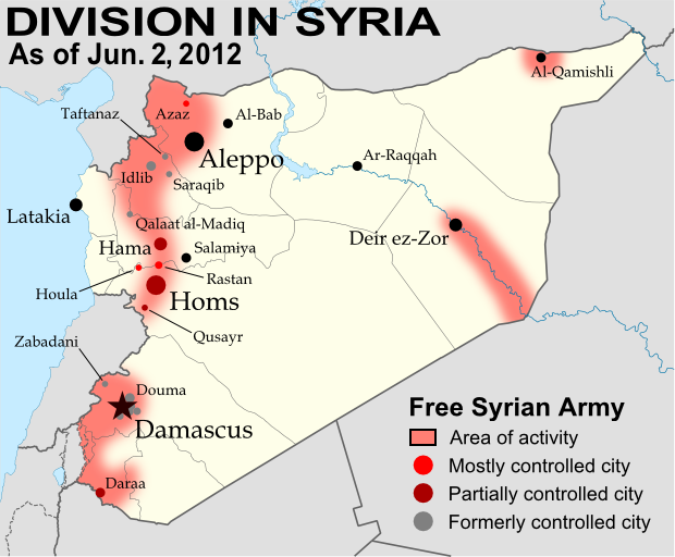
Map of Syria's uprising, marking cities and towns under control of the Free Syrian Army rebels as of June 2, 2012. Includes the site of the recent Houla massacre.
Known areas of armed activity for the rebel “Free Syrian Army” (click to enlarge). My own work, starting from this blank map by NordNordWest. License: CC BY-SA

Wondering what’s been going on in Syria since our last map update? There have been few, if any, major changes in territorial control, but here’s a brief status update. 

Despite the U.N. brokered ceasefire between the Syrian military and the rebel Free Syrian Army, which was to enter in effect on April 10, armed clashes have continued in many parts of the country, including recent heavy fighting in Rastan. Bloodshed reached a horrific peak a week ago, as over one hundred civilians – nearly half of them children – were massacred in the Houla area of Homs province. Witnesses told the U.N. that the murders were committed by militias loyal to President Assad, though the Syrian government attempted to blame the atrocity on the rebels. In the aftermath, one commander of the Free Syrian Army threatened to call off the ceasefire altogether, which could mean increased fighting in the coming weeks.

Country Name:  
• Syria (English)
• Sūriyya/Sūryā (Arabic)
Official Name:  
• Syrian Arab Republic (English)
• al-Jumhūriyyah al-‘Arabīyah  as-Sūriyyah (Arabic)
Capital: Damascus

Territorial control by the government and rebels has remained mostly the same since April. The only change made to the map is the addition of Houla in red, as at least one source indicates the area was under rebel control both before and after the massacre. Note that the Free Syrian Army is also reported to control much of the northwestern Idlib province outside of the main cities, though the situation is fluid and information is scarce, making it difficult to mark anything definitively on the map. 

Syrian Uprising: Map Update 3

There are newer versions of this map available. To see them, view all Syria updates.

Country Name: Syria (English), Sūriyya/Sūryā (Arabic)
Official Name: Syrian Arab Republic (English),
al-Jumhūriyyah al-‘Arabīyah as-Sūriyyah (Arabic)
News Category: Divided Countries
Full Story: See Syria Divided by Armed Conflict

Map of Syria, showing control by the rebel Free Syrian Army as of April 10, 2012
Known areas of armed activity for the rebel “Free Syrian Army”, marking controlled cities and notable towns.
Many rural areas may also be under full rebel control. Unarmed protests not shown. Map is my own work,
starting from this blank map by German Wikipedia user NordNordWest. License: CC BY-SA

Syria Conflict Update
In the three weeks since our last Syria update, the Syrian military has continued its campaign to retake the northern province of Idlib from the rebel Free Syrian Army (FSA). Having retaken Idlib city earlier in the month, the government forces then targeted the province’s second largest city, recapturing Saraqib (Saraqeb) after a four-day battle ending on March 28. In an offensive which is still ongoing despite plans for a U.N.-brokered ceasefire, the Syrian military has also overrun a number of previously rebel-held towns and villages in the Idlib area, most recently taking the town of Taftanaz in an especially bloody battle this week.

Meanwhile, a new front has opened up in the north of Aleppo province, where according to some reports the rebels have controlled the city of Azaz and other towns since early March. In central Syria, the battle continues for the city of Homs, of which the FSA still controls some northern areas. The historical site of Qalaat al-Madiq (Madiq Castle) in Hama province also made news at the end of last month, as the Syrian army stormed the town after a two week siege (government-friendly media later reported that the town had been completely captured).

Useful Link: Wikipedia – Timeline of the 2011-2012 Syrian Uprising

Declaration of Independence of Azawad (English Translation)

Country Name: Azawad (English, Tuareg, French), Azawād (Arabic)
News Categories: New Countries, Breakaway States, Unrecognized States
Full Story: New Country: Azawad Declares Independence from Mali

Flag of Azawad (image by Orionist; source)

Presented here is the full text of the Declaration of Independence of Azawad, originally posted in French to the website of the National Movement for the Liberation of Azawad (MNLA) on April 6, 2012, and translated into English by Evan Centanni of Political Geography Now. The MNLA is a Tuareg-led rebel group which has recently achieved control of the northern part of Mali in West Africa. For a history of the 2012 Tuareg rebellion in Mali, view all Mali posts on Political Geography Now.

Original Document: Declaration of Independence of Azawad (French)

**********************

DECLARATION OF INDEPENDENCE OF AZAWAD
[Unofficial translation by Political Geography Now]
WE, THE PEOPLE OF AZAWAD,
By the voice of the National Movement for the Liberation of Azawad after consultation with:
  • The Executive Committee,
  • The Revolutionary Council,
  • The Advisory Council,
  • The Staff of the Liberation Army,
  • The regional bureaus
Recalling the principles of international law and the principle international legal instruments governing the right of peoples to self-determination, particularly Articles 1 and 55 of the United Nations Charter, and the relevant provisions of the international Declaration of the Rights of Indigenous Peoples;
Considering the will expressed explicitly in the letter dated 30 May, 1958, addressed to the French president by the notables, spiritual leaders of all constituent parts of AZAWAD;
Considering that in 1960, on the occasion of the granting of independence to West African peoples, France attached AZAWAD without its consent to the Malian state that France had just created;
Recalling the massacres, the atrocities and abasement, the plundering and genocide of 1963, 1990, 2006, 2010 and 2012, which targeted exclusively the people of AZAWAD up until 1 April 2012;
Recalling the inhumane conduct of Mali, which utilized the various droughts (1967, 1973, 1984, 2010, etc.) to eradicate our people by devastation even as it sought and obtained generous humanitarian support;
Considering the accumulation of more than 50 years of bad governance, of corruption and of military-political-financial collusion, threatening the existence of the people of AZAWAD and imperiling regional stability and international peace;
Considering the complete liberation of the territory of AZAWAD;
Proclaim irrevocably the INDEPENDENT STATE of AZAWAD starting from this day, Friday, 6 April, 2012.

WE DECLARE:
  • Recognition of existing borders with neighboring states, and their inviolability;
  • Full adherence to the UN Charter;
  • The firm commitment of the MNLA to create conditions for lasting peace, to introduce the institutional foundations of the state based on a democratic constitution for independent Azawad.
The Executive Committee of the MNLA invites the entire international community in a spirit of justice and peace to recognize without delay the independent state of AZAWAD.
The Executive Committee of the MNLA, until the establishment of the Authority of the Territory of AZAWAD, will continue to manage the entirety of the territory.


GAO – 2012/04/06

SECRETARY-GENERAL – MNLA

BILLAL AG ACHERIF

New Country: Azawad Declares Independence From Mali

Country Name: Azawad (English, Tuareg, French), Azawād (Arabic)
News Categories: New Countries, Breakaway States, Unrecognized States
Summary: Tuareg-led rebels in northern Mali have declared “the independent state of Azawad”, after taking control of all of the region’s major cities and military bases and advancing to near the edge of their claimed territory. Azawad is not recognized as an independent country by any U.N. members, making it an example of a so-called “breakaway state”.

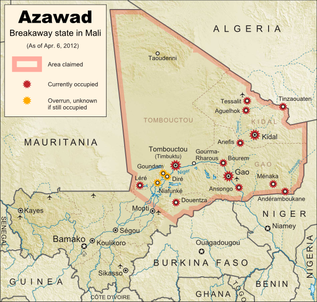
Map of the new independent state of Azawad, declared by MNLA Tuareg rebels in northern Mali. Shows claimed territory and towns controlled by the rebels group as of April 6, 2012
Map of State of Azawad, declared by the Tuareg-majority MNLA rebel group in Mali. Modified from Wikimedia map by Orionist, incorporating images by Carport and NordNordWest (source). License: CC BY-SA.

See Also: Mali Divided by Separatist Fighting; all Mali map updates

MNLA Claims Independent Azawad
The National Movement for the Liberation of Azawad (MNLA) today declared independence from Mali via a statement in French on its website. The rebels of the MNLA, mostly from the Tuareg ethnic group of the Sahara Desert, claim that the northern region of Mali, which they call Azawad, was wrongly included in that country when it declared its independence from France in 1960. There has not yet been any announcement on what form of government Azawad will have, or on which city will be its capital, but the MNLA says it is committed to democracy, to following the rules of the U.N., and to respecting the borders of other countries in the region.

Full Text: Declaration of Independence of Azawad (English Translation)

Flag of the independent state of Azawad, as claimed by the MNLA Tuareg rebel group in northern Mali
Flag of Azawad (image by Orionist; source)

The breakaway state of Azawad is not yet recognized diplomatically by any of the world’s other countries, and is unlikely to be any time soon. It joins the ranks of the various wholly or partially unrecognized states of the world, including fellow African state Somaliland, which similarly controls its whole territory despite complete lack of recognition from either the U.N. or other states. This status will likely prevent Azawad from appearing on mainstream world maps for some time to come.

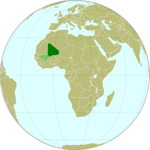
Map showing the location of the new state of Azawad in Africa, declared by the MNLA Tuareg rebel group in northern Mali
Azawad (dark green) and remainder of Mali (light green) in
Africa. Modified from this Wikimedia map (public domain).

Update on Territorial Control
Since our last map update, the Tuareg rebels of the MNLA advanced as far as the town of Douentza (according to their own claims, which have not been disputed), after which they declared a ceasefire, saying they had completed their mission to liberate Azawad. The town of Niafunké has also apparently switched hands a few times over the last few months (source in French), with its current situation unclear. The reality is that the Malian military probably no longer controls anything within the claimed territory of Azawad. Towns not shown as rebel-controlled on the map may simply not be occupied by anyone.

However, the new state of Azawad now faces a threat from another direction – the Islamist Ansar Dine militia, which fought alongside the MNLA over the last few months (with or without their approval). Ansar Dine is now attempting to install strict Sharia (Islamic law) in the cities, in opposition to the MNLA’s claimed desire for a secular state. An additional complication is that Ansar Dine in fact does not support independence for Azawad, believing instead that Sharia law should be instated throughout Mali. Ansar Dine is also a Tuareg-led group.

Seen this Mali conflict map on Wikipedia?
While Political Geography Now sometimes uses free maps from Wikipedia or other sites (after double-checking their sources), we also occasionally post our own maps to Wikipedia and Wikimedia Commons for others to use. The first version of this particular map of the Tuareg-led rebellion in Mali was created for Wikipedia by Orionist, but I have since taken charge of keeping it updated, with a bit of help from Mnmazur on Wikimedia Commons (Mnmazur is not associated with Political Geography Now).

Mali Conflict Map: Separatist Capture Timbuktu and Gao (April 2012)

Country Name: Mali (English, French, Bambara)
Official Name: Republic of Mali (English), République du Mali (French)
News Category: Divided Countries
Summary: Tuareg-led rebels in northern Mali have now completed their control of the region’s major cities, after capturing the military headquarters in Gao as well as historic Timbuktu. Meanwhile, Mali has been suspended from regional organization ECOWAS in response to the recent coup d’etat in the capital, Bamako.

Map of Tuareg rebellion in Northern Mali (Azawad), showing towns controlled by the MNLA rebel group as of April 1, 2012
Towns captured by the Tuareg-majority MNLA rebel group in Mali. Modified from Wikimedia map by Orionist, incorporating images by Carport and NordNordWest (source). License: CC BY-SA.

Full Story: Mali Divided by Separatist Fighting; all Mali map updates

Conflict Update
Again immediately following our last update, northern Mali’s National Movement for the Liberation of Azawad (MNLA), made up mostly of Saharan Tuareg people, has followed its victory in Kidal by capturing the region’s other two major cities. On March 31, the rebels took control of Gao, headquarters of the Malian military in the north, and the next day overran Timbuktu, a historic former trading post and modern tourism destination. The town of Aguelhok in the north is now also being reported as under Tuareg control, though it is unclear when it was recaptured (the rebels had previously taken and lost it again back in January).

The military government of Mali, which took over in a recent coup d’etat, has now withdrawn its forces from most of northern region, known to the Tuareg rebels as Azawad. Neighboring countries have offered military assistance only if the country returns to democracy, and have suspended Mali’s membership in the Economic Community of West African States (ECOWAS) while imposing tough sanctions. If help doesn’t come soon, the MNLA could be in the position to declare independence in the north, making Azawad Africa’s newest country.

Follow events as they develop on Political Geography Now! To see only stories about this ongoing conflict, filter posts using the Mali label.

Seen this map on Wikipedia?
While Political Geography Now sometimes uses free maps from Wikipedia or other sites (after double-checking their sources), we also occasionally post our own maps to Wikipedia and Wikimedia Commons for others to use. The first version of this particular map of the Tuareg-led rebellion in Mali was created for Wikipedia by Orionist, but I have since taken charge of keeping it updated, with a bit of help from Mnmazur on Wikimedia Commons (Mnmazur is not associated with Political Geography Now).