Map Update: Kosovo Recognized by 3 More Countries (103/193)

Map of countries that recognize the Republic of Kosovo as an independent state, updated for October 2013 with most recent additions (Thailand, Libya, Granada) and disputed recognitions highlighted
Countries recognizing the Republic of Kosovo in green, highlighting recent additions. Disputed recognitions in yellow. Kosovo in magenta. Map by Evan Centanni, modified from public domain graphic (source).

Flag of the Republic of KosovoCountry Name:  
• Kosovo (English, Serbian)
• Kosova (Albanian)
Official Name:  
Republic of Kosovo (English)
Republika e Kosovës (Albanian)
Republika Kosovo (Serbian)
Capital: Pristina/Prishtina

By Evan Centanni

New Kosovo Recognitions
Late last month, three more countries extended formal recognition to the self-proclaimed Republic of Kosovo. The breakaway state in southeastern Europe now is recognized as independent by at least 103 U.N. member countries (53%). As discussed in our previous Kosovo recognition map update, there are three additional recognitions which are currently in question. Political Geography Now has now chosen to exclude all of these from future tallies until the question of their validity is resolved.

The three U.N. member countries which have recently recognized Kosovo are Thailand in Southeast Asia, Libya in North Africa and Grenada in the Caribbean. All three offered their recognition within a few days of each other near the end of September, during the meeting of the U.N. General Assembly in New York. Libya’s decision in particular was publically announced from the sidelines of that meeting.

The Republic of Kosovo declared independence from Serbia in 2008, but has been blocked from U.N. membership by objections from Serbia, Russia, and other countries who see its secession as invalid. In addition to the 103 U.N. members recognizing Kosovo, its independence is also acknowledged by non-U.N. member Taiwan. For more on Kosovo’s special situation, see our first Kosovo recognition report, which also includes a map of Kosovo’s location relative to Serbia.

Stay Up to Date: Check for further news and map updates on Kosovo’s recognition by viewing all Kosovo articles on Political Geography Now.

Related Articles:
Kosovo Recognition Map Update: August 2013
North Kosovo Status Changing After Serbia Deal
Who Recognizes Palestine in 2013?
 

Flag graphic by Cradel (source). License: CC BY-SA

Libya Changes Official Name

Map of rebel campaigns during the last stage of Libya's 2011 civil war
Map of the last stage of Libya’s 2011 civil war (click to see full map and original article). Map by Evan Centanni, based on public domain map from Wikipedia (source).

State of Libya
Last month, the North African country of Libya changed its official long-form name to “State of Libya” (Arabic: Dawlat Libya). This comes as part of Libya’s governmental transition following its 2011 civil war, in which a rebel coalition defeated the regime of dictator Muammar Gaddafi.

Over the last year, the country’s formal name had not been clearly defined, with the country referred to in most documents simply as “Libya”. The rebel National Transitional Council had only made a point of ceasing to use the Gaddafi-era name.

During the last decades of Gaddafi’s reign, the country was known in long form as the “Great Socialist People’s Libyan Arab Jamahiriya”. The word “jamahiriya” was coined by Gaddafi by combining the Arabic words for “republic” (jumhuriya) and “the masses” (jamahir).

The new name, “State of Libya”, voted in by the country’s General National Congress on January 8th, is intended to be temporary pending the approval of a new national constitution. However, it is entirely possible that the constitution, once drafted, could also choose to use the same name.

This marks the third year in a row that a country has changed its official name during the year’s first two months: last January, the Republic of Hungary changed its name to just “Hungary”, and in February 2011, the Republic of the Fiji Islands shortened its name to “Republic of Fiji”.

Libya Reunited Under Rebels

Country Name (official): Libya (English), Lībyā (Arabic)
News Category: Divided Countries
Summary: Libya’s civil war came to an end two weeks ago, as rebels under the National Transitional Council (NTC) completed their two-month campaign to flush out the last forces loyal to dictator Muammar Gaddafi. After taking the capital city of Tripoli in August, the NTC had already assumed Libya’s seat in the United Nations, the African Union, and the Arab League, with formal recognition from 100 U.N. member states. With the end of the war, the air-based foreign military intervention that helped bring victory to the rebels has also now come to a close.

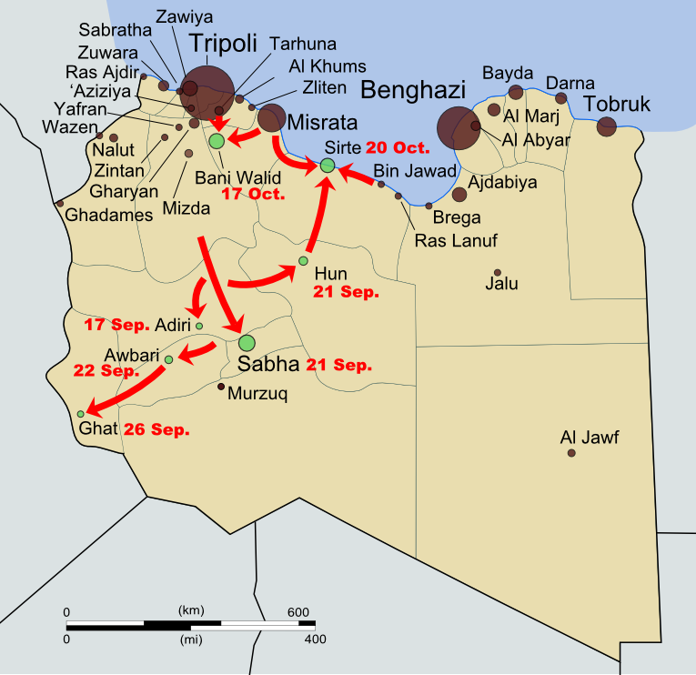
The NTC’s last campaigns to reunite Libya. Gaddafi-held cities (green) and
rebel-held cities (black) as of 2 Sep. Rebel movements and capture dates
in red. My own work based on public domain map from Wikipedia (source).

Full Story
Libya’s participation in the “Arab Spring” movement happening across the Middle East and North Africa began as a series of protests in February, and quickly transformed into an armed uprising after national leader Muammar Gaddafi responded with violent crackdowns. Soon the country’s territory was divided between Gaddafi’s government and rebel forces under the National Transitional Council (NTC), with the latter dominating the eastern half of the country as well as the western mountains near Tripoli, the national capital. A near-stalemate held for about five months, as a U.N.-mandated no-fly zone and NATO-led bombing campaign kept Gaddafi’s forces at bay. Then, in late August, the rebels suddenly stormed into Tripoli, taking the national capital and many of the surrounding areas. The Gaddafi government only remained in control of a few scattered cities and desert outposts.

See Also: Political Geography Now: Libyan Rebels Take Capital

The NTC’s official flag of Libya (bottom) has replaced that
of Gaddafi (top). Public domain, from this Wikipedia page.

For two months following the takeover of Tripoli, the NTC mounted a campaign to drive out the last bastions of Gaddafi loyalist control and reunite the country under their own banner. The first area to fall was the southwestern Fezzan, a desert region with Sabha as its major city, in mid-to-late September. Then came Tripoli’s neighbor Bani Walid on 17 October, and finally Gaddafi’s hometown of Sirte three days later. As Sirte fell to the rebels, Gaddafi himself was finally captured, and soon died under mysterious circumstances. NTC Chair Mustafa Abdul Jalil declared the war officially over on 23 October. NATO’s enforcement and bombing mission ended one week later, following the U.N. Security Council’s withdrawal of its authorization for a no-fly zone and military protection of civilians. The rebel victory also brings an end to the dispute over the country’s flag (see illustration at left) and its official name, now just “Libya” rather than Gaddafi’s inventive “Great Socialist People’s Libyan Arab Jamahiriya.”

Wikipedia: 2011 Libyan Civil War

As the NTC rebels expanded their control over the country and Libyan diplomats abroad defected by the dozen, many countries around the world made the gesture of recognizing the NTC as the legitimate government of Libya. One hundred U.N. member states and four non-member states have declared their recognition of the new government, though the point is largely moot now that the NTC officially represents Libya in the United Nations itself. On 16 September, the U.N. General Assembly voted by a majority to hand over the country’s seat to the NTC, with 114 countries in favor and only 17 countries from Africa and Latin America voting against (a number of other delegations abstained or were absent). The African Union, within which Muammar Gaddafi was until recently a prominent figure, had declined to fully support the rebels during the war, but finally authorized the NTC to hold Libya’s seat in the organization on 20 October. Libya is also a member of the Arab League, which handed representation over to the NTC after the fall of Tripoli in August. Prior to that, Libya’s Arab League membership had been suspended in support of the rebels.

Countries officially recognizing the NTC during the war in dark blue, and countries officially opposing it in dark red. Libya in yellow. Countries in lighter colors unofficially acknowledged or opposed the NTC through diplomatic activities or votes in the U.N. General Assembly. Slightly modified from public domain Wikimedia map (source).

Wikipedia: International Recognition of the National Transitional Council

Libyan Rebels Take Capital

Country Name: Libya (English), Lībyā (Arabic)
Official Name (National Transitional Council): Libya, Libyan Republic
Official Name (Gaddafi Regime): Great Socialist People’s Libyan Arab Jamahariya (English), al-Jamāhīriyyah al-‘Arabiyyah al-Lībiyyah ash-Sha‘biyyah al-Ishtirākiyyah al-‘Uẓmá (Arabic)
News Category: Divided Countries
Summary: Libyan rebels last month took sudden control of the national capital of Tripoli and other cities, ending months of stalemate in the North African country’s civil war. Although the old government of Muammar Gaddafi maintains control of a few holdout cities, the rebel National Transitional Council is gaining increasing recognition internationally. The power transition is bringing with it changes to the country’s flag and official name.
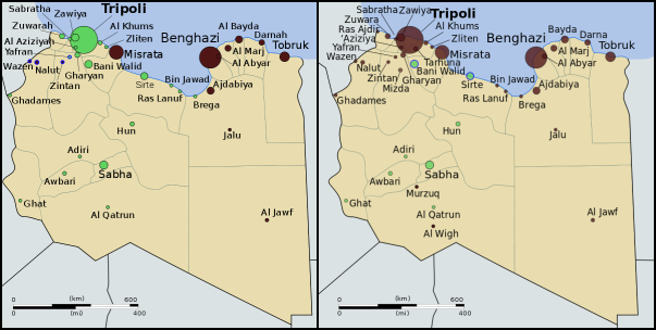
Control of Libya on June 1 (left) and September 2 (right). Gaddafi-held cities in green, rebel-held cities in
black. Blue represents ongoing struggle for control. Public domain maps from Wikimedia (source).


Full Story
Libya’s division between warring factions began in mid-February of this year, during the height of the “Arab Spring” protests happening across the Middle East and North Africa. Dictatorships in Tunisia and Egypt had recently fallen to popular protest movements, and many Libyans were fed up with their country’s erratic and sometimes brutal leader, Muammar Gaddafi. Protesters hit the streets, and when the government answered with violent crackdowns, the protesters fought back. Within days, several cities in eastern Libya had fallen to the rebels, who by the end of the month controlled most of the country’s east and some parts of the west. A government counteroffensive stalled after intervention by NATO, and the country was effectively divided in two, with rebel-held territories governed by the National Transitional Council (NTC) and the remainder under Gaddafi’s control.

Link: Interactive map of the Libyan uprising (February-April) – The New York Times

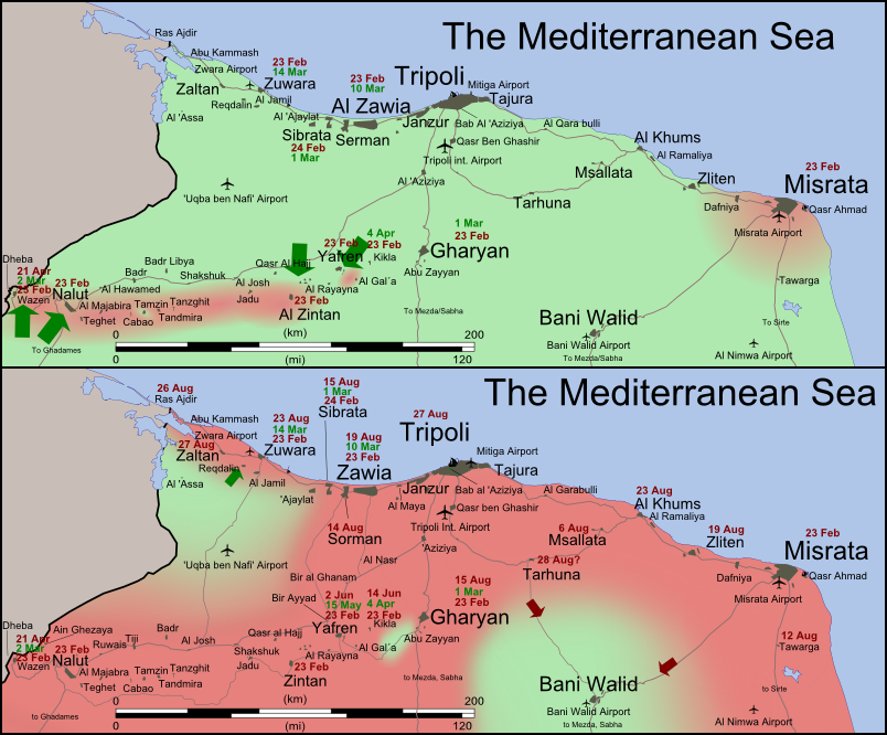
Control of northwestern Libya on June 1 (top) and September 2 (bottom).
Gaddafi-held territory is shown in light green; rebel-held territory is
shown in dark pink. Map by Wikimedia user Rafy (source; CC BY-SA).

The civil war in Libya remained in apparent stalemate for the next five months, with the two sides trading small amounts of territory but not making any major gains. All that changed in late August, when rebel forces suddenly began taking more western towns, then quickly stormed into the capital city of Tripoli, taking control and securing Gaddafi’s headquarters. More rebel gains followed on the eastern front. Gaddafi himself, along with much of his family, escaped from Tripoli and has not yet been located. Forces loyal to him remain in control of the cities of Sabha, Bani Walid, and Sirte – the last of which is Gaddafi’s hometown. Meanwhile, the NTC is in the process of moving its headquarters from its unnofficial capital in Benghazi to the official capital in Tripoli, and many Libyan embassies around the world have switched their allegiance from Gaddafi to the NTC. With international recognition for the NTC growing, the new government seems likely to soon fully replace Gaddafi as representative of the Libyan people on the international stage.

Wikipedia: 2011 Libyan Civil War

The flag of Libya under the Gaddafi regime (top) and under
the NTC (bottom). Public domain, from this Wikipedia page.

Changing Flag and Country Name
As with most revolutions, the rebellion in Libya has brought with it a changing identity. The rebel National Transitional Council, and the movement that spawned it, have been quick to discard any symbols of the Gaddafi regime. One of the most prominent of these symbols is the national flag. For decades, Gaddafi’s Libya has been known by it’s unique flag design: a plain, unmarked green rectangle. The rebel movement, on the other hand, has mostly used the flag of the Kingdom of Libya which Gaddafi overthrew, composed of red, black, and green stripes, with the crescent and star of the Ottoman Empire in white at the center. This was declared the official flag by the NTC, and is now flown at the United Nations and most of Libya’s embassies abroad.

Wikipedia: Flag of Libya

Another eccentricity of Gaddafi’s Libya was the country’s full official name, translated into English as the Great Socialist People’s Libyan Arab Jamahiriya. “Jamahiriya” is a word invented by Gaddafi for what he believed to be a unique and superior form of government, supposedly based on direct rule by the people. The word is a combination of the Arabic words jumhūriyya (“republic”) and jamāhīr (“the masses”). The NTC, again making a point of disassociating itself from Gaddafi, has preferred to simply refer to the country as “Libya”, occasionally using the term “Libyan Republic”.

International Recognition of the NTC
As the rebels and the National Transitional Council consolidate their control of the country, more and more countries are recognizing the NTC as the legitimate government of Libya. For most countries, which already recognize Libya as an independent country, this is a special diplomatic gesture of support for the rebels; or now that the NTC controls most of the country, a gesture of acceptance of the current state of affairs. The number of states recognizing the NTC has risen drastically, from only 11 when I reported on the situation two months ago, to a current total of 78 U.N. member states and two non-U.N. members (Palestine and Kosovo). Several more U.N. members have established diplomatic relations with the new Libyan government without making formal declarations of recognition. However, at least four countries – Venezuela, Zimbabwe, Ecuador, and Nicaragua – have stated their refusal to recognize the change in government.

Countries officially recognizing the National Transitional Council in dark blue; countries maintaining diplomatic relations with the NTC without official recognition in light blue; countries refusing to recognize the NTC in red;
Libya in yellow. Slightly modified from public domain Wikimedia map (source).

News Bits: June 2011

“News Bits” posts cover minor political geography events from the previous month. Although the news may be of great political relevance, these events haven’t (yet) affected major changes to the shapes, sovereignty, or international positions of the world’s countries.

Abyei’s location within Sudan
(yellow). The south (blue) gains
independence this July. Based
on this map (license: CC BY-SA).

Sudan Government Forces Overrun Disputed Abyei
The Abyei Area, subject of a territorial dispute between the central Government of Sudan and the autonomous Southern Sudan region, has been invaded by Sudanese government forces. Southern troops, who had shared joint control of the area with the central government, have been driven out, along with many of the area’s inhabitants. Southern Sudan is set to become an independent country this July, based on the 2005 peace agreement that ended Sudan’s second civil war. A referendum was planned for Abyei residents to choose whether they would stay in Sudan or join the new Republic of South Sudan, but it was never held due to disagreements about who was eligible to vote. The Sudan government in Khartoum has asserted that it will not give up Abyei, and southern president Salva Kiir has promised not to go to war again over the territory.

Israel with occupied territories (green).
The PLO claims both the West Bank
and Gaza Strip, but they are currently
ruled by rival factions (map source).

West Bank & Gaza Strip to be Reunited
Rival Palestinian political parties Fatah and Hamas have agreed to form a new unity government in the coming months, which will effectively reunite their respective territories in the West Bank and Gaza Strip. Both groups claimed control of the Palestinian Authority (PA) government after a brief civil war following the 2006 elections, in which Hamas won a majority of seats in the previously Fatah-dominated Palestinian Legislative Council. The armed clash left Hamas in control of the Gaza Strip, while Fatah retained its authority in the Palestinian-controlled areas of the West Bank. Known to the U.N. as the Occupied Palestinian Territories, the West Bank and Gaza Strip are claimed as the State of Palestine by the Palestinian Liberation Organization (PLO), parent organization of the PA. Over half of the U.N.’s member countries have recognized the state’s independence, but the U.N. itself has not. Furthermore, the territories remain under military occupation by Israel, which controls much of the West Bank as well as all air space and territorial waters in the region.

Peruvian and Ecuadorian waters, with the newly agreed
upon boundary marked in yellow. My own work, based
on data sources listed on map (terms of use).

Ecuador & Peru Define Sea Border
The neighboring South American countries of Ecuador and Peru have formally agreed on a boundary between their respective territorial waters in the Pacific Ocean. Although the location of the border was never actively in dispute, its acceptance had been called into question by Peru’s ongoing territorial dispute with Chile, in which Peru claims a 1952 agreement between the three countries did not technically establish the location of their maritime borders. The new agreement is widely seen as a move by Peru to gain Ecuador’s support as the case of the Peru-Chile conflict heads to the International Court of Justice. The agreed upon boundary is located along the parallel of 3° 23′ 33.96″ S, originating at the point where the countries’ land border reaches the ocean.

Libya as of June 1, 2011. Cities controlled by Gaddafi
government in green, rebel-held cities in black, and
areas of ongoing fighting in blue. Public domain map
from Wikipedia (source).

Libyan Rebels Gain Further Recognition
Libya’s rebel National Transitional Council (NTC) over the last month gained diplomatic recognition from five more national governments, bringing to 11 the list of countries recognizing its legitimacy. The NTC forms the political leadership of the rebel forces fighting for control of the North African country against dictator Muammar Gaddafi, in a civil war provoked by Gaddafi’s violent crackdown on popular protests last February. Although Libya’s independence is already recognized by the U.N. and all of it’s members, countries have begun to make the special diplomatic gesture of switching their recognition from Gaddafi’s government to the NTC. Recent additions to the list are Jordan, Russia, and Malta; two other countries, Senegal and Turkey, have acknowledged the NTC’s status as a legitimate opposition group, while still maintaining ties with Gaddafi. Six other countries, starting with France in early March, had all previously recognized the NTC as Libya’s sole representative, some of them expelling Gaddafi’s diplomats and sending ambassadors to the rebel command center in Benghazi. As Gaddafi’s forces continue to face NATO bombing attacks, the war has ground to a near-stalemate, with Gaddafi controlling the capital city of Tripoli and several smaller western cities, while the rebels control the eastern half of the country and some areas of the west.