Syria Divided by Armed Conflict (Feb. 2012)

There are newer versions of this map available. To see them, view all Syria updates.

Country Name: Syria (English), Sūriyya/Sūryā (Arabic)
Official Name: Syrian Arab Republic (English), al-Jumhūriyyah al-‘Arabīyah as-Sūriyyah (Arabic)
News Category: Divided Countries, Intergovernmental Organizations
Summary: Ten months in Syria’s popular uprising, parts of the country have fallen out of government hands and into the control of the “Free Syrian Army,” a group made up mostly of defectors from the national military. Meanwhile, Syria has been been suspended from the Arab League due its government’s failure to stop using violence against unarmed protesters.
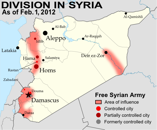
Known areas of armed activity for the rebel “Free Syrian Army” – many rural areas may be under full rebel
control. Unarmed protests, much more widespread than armed rebel activity, are not shown here. Map is my
own work, starting from this blank map by German Wikipedia user NordNordWest. License: CC BY-SA (Corrected
Feb. 26, 2012 for partial Hama control and eastern region activity; again on Mar. 9, 2012 for Rastan control.)

Full Story
The “Arab Spring” has brought incredible upheaval to the the Middle East and North Africa – first the Tunisian and Egyptian dictatorships fell to peaceful protesters; then Libya became embroiled in a civil war, while Yemen too began to fragment under opposing forces. Now, Syria has become the third country in the region to be divided between warring armies, as the 10-month-old uprising has given way to formidable armed resistance from a growing network of military defectors calling themselves the “Free Syrian Army” (FSA).

Wikipedia: Arab Spring

Even before the armed resistance began in earnest last September, the Syrian government and its president, Bashar al-Assad, were making headlines with their brutal crackdowns on peaceful protesters, along with tank-led sieges of disobedient cities. After six months of government violence, the FSA rebels burst onto the stage with a successful, if temporary, takeover of the anti-government city of Rastan (See News Bits: October 2011). They were eventually driven out of Rastan, and moved their headquarters across the border into Turkey, using the next three months to slowly consolidate control over the northwestern province of Idlib, while also gaining ground in the city of Homs and the provinces of Hama and Daraa. [Update: The FSA took control a of Rastan a second time just as this post was being written.]

Map of the Arab Spring. Protests, and in some cases full scale revolutions, have reached across the entire Arab
World. Map is from this Wikipedia page (public domain; original graphic).

All the while, the rebels were hitting targets closer and closer to the capital city of Damascus, until finally in January they successfully seized the nearby city of Zabadani. Fighting around the capital escalated quickly, with the FSA spreading its control across most of the suburbs of Damascus by January 27. Over the next few days, Assad’s government launched a largely successful offensive to take back the areas surrounding the capital, though the rebels still claim control of Douma, Damascus’s most populous suburb. The cities of Homs and Idlib are also reported to be largely under FSA control, along with much of rural Idlib province. And the territorial division in Syria may be even more extensive than we know – journalists have been forbidden to enter the country, making it difficult to follow developments on the ground.

Wikipedia: 2011–2012 Syrian uprising

The Arab League, with Syria in lighter green at top right.
Map by Danalm000, from Wikimedia (license: CC BY-SA)

Arab League Involvement
The League of Arab States (better known as the Arab League), an international organization of which Syria is a founding member, has taken a close interest in the events unfolding within the country. In November, the body voted to suspend Syria’s membership unless President Assad brought an end to the violence against civilian protesters. Assad failed to follow through with any concrete action, and the country was suspended from the League. In January, the organization sent a delegation of observers into Syria to examine the situation; they were allowed inside the country, but eventually were forced to leave due to escalating violence between government forces and the FSA. As the region’s main representative body, the Arab League will likely be a major player in any future decisions by the international community to intervene in Syria’s civil war.

Wikipedia: League of Arab States

Hungary Shortens Official Name

Country Name: Hungary (English), Magyarország (Hungarian)
News Category: Name Changes
Summary: Hungary’s full official name changed from “Republic of Hungary” to just “Hungary” when a new constitution came into effect in the Central European country at the beginning of this year.

Full Story

Map of Hungary from the CIA World Factbook (public domain)

A member of the Soviet-influenced Eastern Bloc during the Cold War, Hungary was one of the many European countries that underwent major reforms after the fall of the Iron Curtain in 1989. Its name was changed from “People’s Republic of Hungary” to “Republic of Hungary”, and the old communist constitution was heavily amended to welcome in democracy.

Flag of Hungary (source)

However, uniquely among the former Eastern states, the old constitution was never completely discarded. Change finally came last year, when the Hungarian parliament, led by the conservative Fidesz party, began drafting a replacement constitution. The new document, which holds the historical distinction of being the first ever national constitution written on an iPad, was signed into law on April 25 and entered into effect on January 1, 2012. Curiously, the new text further reduces the country’s official name from “Republic of Hungary” to just “Hungary”.

Link: Full English text of Hungary’s new constitution (PDF)

Hungary’s location within the European Union (copyright
David Liuzzo, used with permission per its Wikimedia page)

To many of the new constitution’s opponents, the name change symbolizes the authoritarian tendencies of Fidesz and Prime Minister Viktor Orbán, who they have nicknamed “Viktator”. Opposition parties have complained that the constitution was pushed through without broad consensus, enshrining the ruling party’s conservative ideology into the country’s basic law. Among the document’s right-wing provisions are clauses condemning gay marriage and abortion, as well as a pointed failure to protect sexual orientation under anti-discrimination measures. To those who see an anti-democratic constitution whose preamble appeals to a history of monarchy and Christianity, the deletion of “Republic” from Hungary’s name is the icing on the cake.

News Report: Opposition protests fill Hungarian capital (Washington Post & Al-Jazeera)

WTO Admits New Members

Organization: World Trade Organization
Countries in Question: Vanuatu, Russia, Montenegro, Samoa
News Categories: Intergovernmental Organizations
Summary: The World Trade Organization, the intergovernmental organization supervising international trade between the majority of the world’s countries, admitted one new member last October, and three more last week. Especially notable was the admission last Friday of Russia, which was by far the largest economy not to have joined previously.

Full Story
While some intergovernmental organizations, such as the U.N. or regional unions, were created for general purposes of cooperation between states, others serve more specific purposes. The World Trade Organization (WTO) is one of these, acting as a venue for countries to agree on rules for international trade. Among its members, economic agreements are subject to rules aimed at liberalizing international trade, and trade-related disputes are also arbitrated through the organization. Formed in 1995 as a replacement for weaker trade treaties of the past, by 2008 the WTO represented approximately 80% of the world’s independent countries.

World Trade Organization members in green. Countries joining this year in brighter green, with small countries circled. Modified from this Wikimedia map (license: CC BY-SA).

This October, the WTO grew for the first time in three years, with the acceptance of the Pacific island country of Vanuatu’s as a member. Just last week, three more countries joined: Russia, Montenegro, and Samoa. Samoa is another small Pacific island country, and Montenegro was only formed a few years ago from the final breakup of former Yugoslavia. Russia, however, has gained much attention for being the last of the world’s major economic powers to join the organization. Although it first applied for admission to the group 18 years ago, before the modern WTO was even formed, until recently Russia was slow to proceed with membership negotiations. For the last few years, it was blocked from entry by Georgia, a WTO member protesting its invasion by Russia during the 2008 war between the two countries, but that hurdle was finally crossed after a Swiss-brokered agreement between Russia and Georgia earlier this year. Although the four new countries have been accepted by the organization, their governments will still have to ratify the agreements in order for them to become full participating members.

South Sudan Gains Further Recognition

Country Name: South Sudan
Official Name: Republic of South Sudan
News Categories: Recognition, New Countries
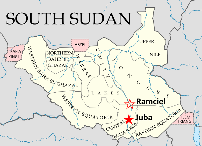
Summary: Newly independent South Sudan has continued to be officially recognized by more of the world’s countries in the follow-up to its formation last July. The new state, whose sovereignty has already been acknowledged through admission to the U.N. and African Union, has also initiated a plan to move its capital from Juba to the more central location of Ramciel.

See Also: New Country: South Sudan

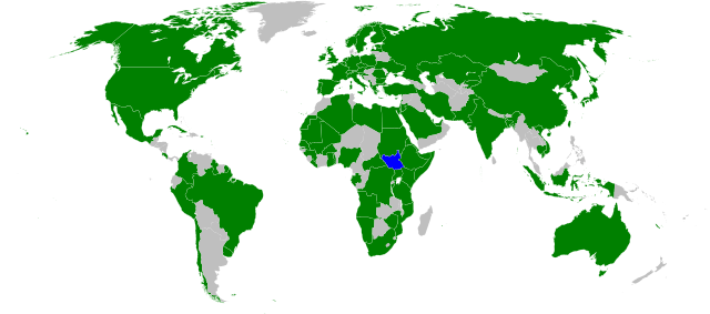
Countries which have officially stated their recognition of South Sudan’s sovereignty (green). South Sudan in blue. Modified from this Wikimedia map (public domain).

Full Story

South Sudan’s Coat of Arms (source)

The result of a peace agreement ending a long and bloody civil war, the official split between South Sudan and Sudan came on July 9th of this year. Since its declaration of independence had been pre-approved through treaty and diplomatic channels, the new Republic of South Sudan was immediately accepted onto the international stage, with dozens of countries rushing to grant it diplomatic recognition. It was welcomed into the United Nations within the week, and by the end of the month held a seat in the African Union. South Sudan has so far received formal recognition from 114 U.N. member states, as well as six non-members. However, since the country already holds a seat in the U.N. itself, and its independence was not opposed by any countries, new recognitions have since slowed due to their limited significance. Since the beginning of August, 10 more countries have recognized South Sudan, with the last newly reported recognition coming from Jamaica on October 6th. (Note: seven other states which recognized the country before August were were omitted from my last update due to lack of information.)

Wikipedia: Foreign Relations of South Sudan

South Sudan’s states and disputed regions (pink), showing the current
capital (Juba) and the planned future capital (Ramciel). My own work,
Based on this map by NordNordWest/Wikipedia (license: CC-BY-SA).

South Sudan’s capital is currently located in the Juba, also its largest city, which is located on the White Nile river in the south of the country. However, there have long been proposals to move the capital to a more central location, and in September the government announced the official location of South Sudan’s next capital, a city which will be planned and built near the meeting point of the country’s three traditional provinces (now divided into a number of smaller states). The site is known as Ramciel, and is said to have been advocated by John Garang, southern Sudan’s leader from the civil war period, who died in a helicopter crash six years before the country achieved its official independence.

See Also: South Sudan Joins U.N.
Wikipedia: South Sudan

Libya Reunited Under Rebels

Country Name (official): Libya (English), Lībyā (Arabic)
News Category: Divided Countries
Summary: Libya’s civil war came to an end two weeks ago, as rebels under the National Transitional Council (NTC) completed their two-month campaign to flush out the last forces loyal to dictator Muammar Gaddafi. After taking the capital city of Tripoli in August, the NTC had already assumed Libya’s seat in the United Nations, the African Union, and the Arab League, with formal recognition from 100 U.N. member states. With the end of the war, the air-based foreign military intervention that helped bring victory to the rebels has also now come to a close.

The NTC’s last campaigns to reunite Libya. Gaddafi-held cities (green) and
rebel-held cities (black) as of 2 Sep. Rebel movements and capture dates
in red. My own work based on public domain map from Wikipedia (source).

Full Story
Libya’s participation in the “Arab Spring” movement happening across the Middle East and North Africa began as a series of protests in February, and quickly transformed into an armed uprising after national leader Muammar Gaddafi responded with violent crackdowns. Soon the country’s territory was divided between Gaddafi’s government and rebel forces under the National Transitional Council (NTC), with the latter dominating the eastern half of the country as well as the western mountains near Tripoli, the national capital. A near-stalemate held for about five months, as a U.N.-mandated no-fly zone and NATO-led bombing campaign kept Gaddafi’s forces at bay. Then, in late August, the rebels suddenly stormed into Tripoli, taking the national capital and many of the surrounding areas. The Gaddafi government only remained in control of a few scattered cities and desert outposts.

See Also: Political Geography Now: Libyan Rebels Take Capital

The NTC’s official flag of Libya (bottom) has replaced that
of Gaddafi (top). Public domain, from this Wikipedia page.

For two months following the takeover of Tripoli, the NTC mounted a campaign to drive out the last bastions of Gaddafi loyalist control and reunite the country under their own banner. The first area to fall was the southwestern Fezzan, a desert region with Sabha as its major city, in mid-to-late September. Then came Tripoli’s neighbor Bani Walid on 17 October, and finally Gaddafi’s hometown of Sirte three days later. As Sirte fell to the rebels, Gaddafi himself was finally captured, and soon died under mysterious circumstances. NTC Chair Mustafa Abdul Jalil declared the war officially over on 23 October. NATO’s enforcement and bombing mission ended one week later, following the U.N. Security Council’s withdrawal of its authorization for a no-fly zone and military protection of civilians. The rebel victory also brings an end to the dispute over the country’s flag (see illustration at left) and its official name, now just “Libya” rather than Gaddafi’s inventive “Great Socialist People’s Libyan Arab Jamahiriya.”

Wikipedia: 2011 Libyan Civil War

As the NTC rebels expanded their control over the country and Libyan diplomats abroad defected by the dozen, many countries around the world made the gesture of recognizing the NTC as the legitimate government of Libya. One hundred U.N. member states and four non-member states have declared their recognition of the new government, though the point is largely moot now that the NTC officially represents Libya in the United Nations itself. On 16 September, the U.N. General Assembly voted by a majority to hand over the country’s seat to the NTC, with 114 countries in favor and only 17 countries from Africa and Latin America voting against (a number of other delegations abstained or were absent). The African Union, within which Muammar Gaddafi was until recently a prominent figure, had declined to fully support the rebels during the war, but finally authorized the NTC to hold Libya’s seat in the organization on 20 October. Libya is also a member of the Arab League, which handed representation over to the NTC after the fall of Tripoli in August. Prior to that, Libya’s Arab League membership had been suspended in support of the rebels.

Countries officially recognizing the NTC during the war in dark blue, and countries officially opposing it in dark red. Libya in yellow. Countries in lighter colors unofficially acknowledged or opposed the NTC through diplomatic activities or votes in the U.N. General Assembly. Slightly modified from public domain Wikimedia map (source).

Wikipedia: International Recognition of the National Transitional Council

News Bits: October 2011

“News Bits” posts cover minor political geography events from the last few months. Although the news may be of great political relevance, these events haven’t (yet) affected major changes to the shapes, sovereignty, or political status of the world’s countries.

Yemen: Militias Take Territory From Islamists

Territory and areas of influence for rebels (blue) and Islamic
extremists (red) in Yemen. Map is my own work, starting
from this map by German Wikipedia user NordNordWest
(license: CC BY-SA). (Corrected November 20, 2011)

In Yemen’s ongoing political crisis (See: Yemen Fragments Under Uprising), some territory previously held by Islamist militants has fallen under the control of unsympathetic non-government forces, whose presence around the country seems to be expanding. The Islamists, who call themselves Ansar al-Sharia (“Partisans of Islamic Law”), have occupied the cities of Jaar, Zinjibar, and Shuqra in Abyan province for several months now, along with various smaller towns both in Abyan and in heighboring Shabwah. However, since July, many of the smaller towns have fallen into the hands of local militias, and the Yemeni government has gained ground in the Zinjibar area. Though the local militias are currently working alongside the government, it is unclear whether it may be only a temporary truce. Yemen’s opposition forces are composed of a mixture of local and kinship-based militias, army defectors, and pre-existing rebel groups, which sometimes work together but are increasingly clashing among themselves. The country’s third largest city, Taiz, is largely under the control of opposition forces, as are some parts of the capital, Sana’a. (More Yemen news on Political Geography Now)

Sudan No Longer Africa’s Largest Country
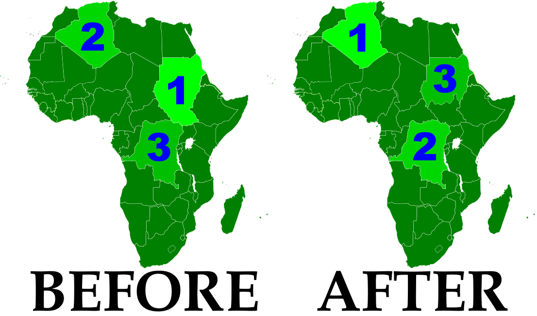
Now that the South Sudan has gained independence (See: New Country – South Sudan), the remainder of Sudan is no longer Africa’s largest country by area. Sudan’s one-time top spot was  followed by Algeria in second place and the Democratic Republic of the Congo in third. However, the secession of South Sudan  removed a substantial portion of Sudan’s territory, and the northern remainder of the country now ranks third in Africa – after Algeria and the DRC. South Sudan ranks 19th, out of a total of 54 U.N.-recognized countries in Africa. (Graphic my own work, based on this map by Wikipedia user Mangwanani. License: CC BY-SA)

Map showing most of the Cooch Behar
enclaves. By Dutch Wikipedia user
Jeroen (source). License: CC BY-SA

Wikipedia: List of African Countries and Territories

Indo-Bangladesh Treaty Defines Border, Trades Enclaves
A treaty signed last month between the governments of India and Bangladesh fully defines the border between the two countries, and provides for the trade of dozens of enclaves. The Indo-Bangladesh enclaves, also known as “chitmahals” or the “Cooch Behar enclaves” (after the district of India which most of them either belong to or are located inside), number well over 100, including patches of Indian territory within Bangladesh and patches of Bengladeshi territory within India. Their inhabitants have long suffered under abominable living conditions due to the fact that they have access neither to services from their own country (because of their isolation) nor to services from the country surrounding them (because they are not considered part of its territory). Under the new agreement, based on a 1974 deal that was never adopted, nearly all of the enclaves will be ceded to whichever country surrounds them, and inhabitants will have a choice of citizenship. The two parties also defined the border in several previously disputed or undemarcated areas. The treaty will not go into effect until it is ratified by both countries’ legislatures.

Location of Rastan within Syria. Based on this
map
by German Wikipedia user NordNordWest.
License: CC BY-SA

Syrian City Falls Briefly to Rebels
In Syria’s ongoing uprising, the city of Rastan fell under control of protester-friendly rebel forces for a few weeks last month, before ultimately being retaken by government troops. The crisis in Syria, seen as part of the so-called “Arab Spring” movement for democratic change in the Middle East, began with protests last January. By march it had escalated to widespread displays of defiance in the streets, to which the government responded by sending in tanks and soldiers. However, the resistance was mostly unarmed until army defectors began organizing against the military in September. The city of Rastan, one of several major protest centers, was taken over by anti-government forces, which were not driven out until October 1. So far there have been no more reports of Syrian cities falling under armed anti-government control, but protests and violent government crackdowns continue in full gear.

States Recognize Palestine Ahead of U.N. Bid

Country Name: Palestine (English), Filastin (Arabic)
Official Name: State of Palestine (English), Dawlat Filastin (Arabic)
News Category: Partially Recognized States, Diplomatic Recognition
Summary: The Palestinian Liberation Organization, which claims sovereignty over the disputed territories of the West Bank and Gaza Strip as the State of Palestine, will apply for U.N. membership this week. Meanwhile, the total number of countries recognizing Palestinian independence has grown sharply in the lead-up to the U.N. bid.

The Palestinian Territories. Area A: Full Palestinian Control
(on the ground); Area B: Joint Palestinian-Israeli Control;
Area C: Full Israeli Control. Israeli government considers
the green areas “disputed territory”. Map is my own work.
Sources: Natural Earth, B’Tselem, U.N. OCHA oPt, others.

Full Story
Palestine is a unique case within the nation-state system. It is recognized as an independent state by more than half of the world’s countries, but not by the U.N. itself or by any major Western powers. It indirectly administers much of its claimed territories, yet exercises full sovereign control over none of them. At the heart of one of the world’s most intractable conflicts, it is perhaps the most controversial topic in international politics. The coming weeks could see significant changes to the political status of the Palestinian Territories on the world stage.


The Palestinian Territories are made up of the West Bank and the Gaza Strip, two regions previously controlled by Jordan and Egypt respectively, which were captured by Israel in the Six Day War of 1967. Israel has never fully relinquished control, and Egypt and Jordan eventually gave up their claims to the regions, leaving them in an unusual political situation. Despite widespread calls for independence based on a 1947 U.N. partition plan, Israel refuses to refer to them as anything other than “disputed territories” until negotiations determine their final status. Some of the land within the territories is now administered by the Palestinians, though much of it is still ruled by the Israeli military, which also controls all associated airspace and territorial waters.

Wikipedia: History of the Israeli-Palestinian Conflict 

This week, Mahmoud Abbas, chairman of the Palestinian Liberation Organization (PLO), will formally request full membership for the State of Palestine in the United Nations. The PLO declared independence in 1988, and has enjoyed a degree of support from the U.N. General Assembly, but currently only holds observer status in the organization, which pointedly labels it as a “non-state entity”. Palestinian membership in the U.N. is likely to be vetoed by the U.S., which holds a permanent seat in the U.N. Security Council. However, Palestine may still achieve “state observer” status by a majority vote in the General Assembly, which would elevate it to the same level as the Holy See (Vatican City): a U.N.-recognized state with legal rights.

Countries recognizing the State of Palestine. Recent additions (in the last year) indicated in lighter color.
Modified from this map by Alinor at en.wikipedia (license: CC BY-SA).

Though 90 U.N. members recognized Palestine during the first year after its declaration, the number grew little over the next 15 years. However, since the campaign for U.N. membership began a few years ago, recognition has risen sharply. The State of Palestine is now recognized by 126 U.N. members – nearly two-thirds of the world body – 17 of which have announced their recognition just in the last year. This summer alone has seen six new additions: Syria, Liberia, El Salvador, Honduras, St. Vincent and the Grenadines, and Belize. Palestine’s independence is also endorsed by Western Sahara, a partially-recognized state without U.N. membership.

Chart over time of total U.N. members recognizing the State of Palestine. My own work (source).


Wikipedia:
State of Palestine, Palestinian Territories, International Recognition of the State of Palestine

Libyan Rebels Take Capital

Country Name: Libya (English), Lībyā (Arabic)
Official Name (National Transitional Council): Libya, Libyan Republic
Official Name (Gaddafi Regime): Great Socialist People’s Libyan Arab Jamahariya (English), al-Jamāhīriyyah al-‘Arabiyyah al-Lībiyyah ash-Sha‘biyyah al-Ishtirākiyyah al-‘Uẓmá (Arabic)
News Category: Divided Countries
Summary: Libyan rebels last month took sudden control of the national capital of Tripoli and other cities, ending months of stalemate in the North African country’s civil war. Although the old government of Muammar Gaddafi maintains control of a few holdout cities, the rebel National Transitional Council is gaining increasing recognition internationally. The power transition is bringing with it changes to the country’s flag and official name.

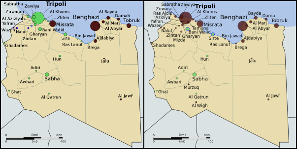
Control of Libya on June 1 (left) and September 2 (right). Gaddafi-held cities in green, rebel-held cities in
black. Blue represents ongoing struggle for control. Public domain maps from Wikimedia (source).


Full Story
Libya’s division between warring factions began in mid-February of this year, during the height of the “Arab Spring” protests happening across the Middle East and North Africa. Dictatorships in Tunisia and Egypt had recently fallen to popular protest movements, and many Libyans were fed up with their country’s erratic and sometimes brutal leader, Muammar Gaddafi. Protesters hit the streets, and when the government answered with violent crackdowns, the protesters fought back. Within days, several cities in eastern Libya had fallen to the rebels, who by the end of the month controlled most of the country’s east and some parts of the west. A government counteroffensive stalled after intervention by NATO, and the country was effectively divided in two, with rebel-held territories governed by the National Transitional Council (NTC) and the remainder under Gaddafi’s control.

Link: Interactive map of the Libyan uprising (February-April) – The New York Times

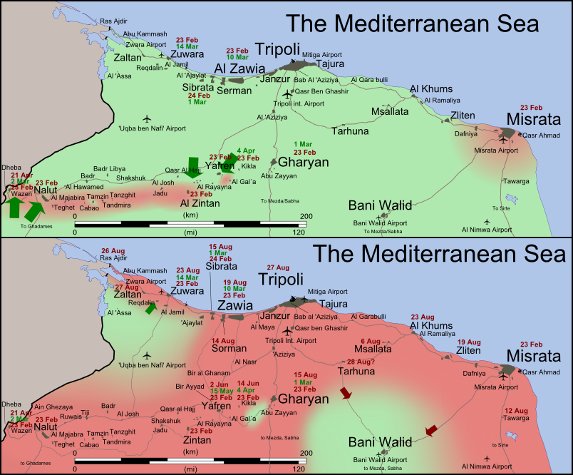
Control of northwestern Libya on June 1 (top) and September 2 (bottom).
Gaddafi-held territory is shown in light green; rebel-held territory is
shown in dark pink. Map by Wikimedia user Rafy (source; CC BY-SA).

The civil war in Libya remained in apparent stalemate for the next five months, with the two sides trading small amounts of territory but not making any major gains. All that changed in late August, when rebel forces suddenly began taking more western towns, then quickly stormed into the capital city of Tripoli, taking control and securing Gaddafi’s headquarters. More rebel gains followed on the eastern front. Gaddafi himself, along with much of his family, escaped from Tripoli and has not yet been located. Forces loyal to him remain in control of the cities of Sabha, Bani Walid, and Sirte – the last of which is Gaddafi’s hometown. Meanwhile, the NTC is in the process of moving its headquarters from its unnofficial capital in Benghazi to the official capital in Tripoli, and many Libyan embassies around the world have switched their allegiance from Gaddafi to the NTC. With international recognition for the NTC growing, the new government seems likely to soon fully replace Gaddafi as representative of the Libyan people on the international stage.

Wikipedia: 2011 Libyan Civil War

The flag of Libya under the Gaddafi regime (top) and under
the NTC (bottom). Public domain, from this Wikipedia page.

Changing Flag and Country Name
As with most revolutions, the rebellion in Libya has brought with it a changing identity. The rebel National Transitional Council, and the movement that spawned it, have been quick to discard any symbols of the Gaddafi regime. One of the most prominent of these symbols is the national flag. For decades, Gaddafi’s Libya has been known by it’s unique flag design: a plain, unmarked green rectangle. The rebel movement, on the other hand, has mostly used the flag of the Kingdom of Libya which Gaddafi overthrew, composed of red, black, and green stripes, with the crescent and star of the Ottoman Empire in white at the center. This was declared the official flag by the NTC, and is now flown at the United Nations and most of Libya’s embassies abroad.

Wikipedia: Flag of Libya

Another eccentricity of Gaddafi’s Libya was the country’s full official name, translated into English as the Great Socialist People’s Libyan Arab Jamahiriya. “Jamahiriya” is a word invented by Gaddafi for what he believed to be a unique and superior form of government, supposedly based on direct rule by the people. The word is a combination of the Arabic words jumhūriyya (“republic”) and jamāhīr (“the masses”). The NTC, again making a point of disassociating itself from Gaddafi, has preferred to simply refer to the country as “Libya”, occasionally using the term “Libyan Republic”.

International Recognition of the NTC
As the rebels and the National Transitional Council consolidate their control of the country, more and more countries are recognizing the NTC as the legitimate government of Libya. For most countries, which already recognize Libya as an independent country, this is a special diplomatic gesture of support for the rebels; or now that the NTC controls most of the country, a gesture of acceptance of the current state of affairs. The number of states recognizing the NTC has risen drastically, from only 11 when I reported on the situation two months ago, to a current total of 78 U.N. member states and two non-U.N. members (Palestine and Kosovo). Several more U.N. members have established diplomatic relations with the new Libyan government without making formal declarations of recognition. However, at least four countries – Venezuela, Zimbabwe, Ecuador, and Nicaragua – have stated their refusal to recognize the change in government.

Countries officially recognizing the National Transitional Council in dark blue; countries maintaining diplomatic relations with the NTC without official recognition in light blue; countries refusing to recognize the NTC in red;
Libya in yellow. Slightly modified from public domain Wikimedia map (source).

Abkhazia Recognized by Vanuatu

Country Name: Abkhazia (English), Apsny (Abkhaz), Abkhaziya (Russian)
Official Name: Republic of Abkhazia
News Category: Partially Recognized States, Diplomatic Recognition
Summary: The disputed breakaway state of Abkhazia has gained diplomatic recognition from Vanuatu, the fifth U.N. member to acknowledge its independence from Georgia.

Abkhazia (purple stripes) and South Ossetia (gold stripes), and their
claimed location within Georgia. Wikimedia map by Ssolbergj (CC BY-SA).

Full Story
The Republic of Abkhazia is one of seven states in the world which are recognized by some U.N. members, but not by the U.N. as a whole. Located in the Caucasus region on the border between Europe and Asia, Abkhazia is considered part of Georgia by most U.N. members; however, it has enjoyed de facto independence since winning a war of secession against the larger country in 1993. It has shared much of its fate with South Ossetia, another breakaway state which also seceded from Georgia around the same time. Abkhazia and South Ossetia passed their first decade and a half of independence without the recognition of any U.N. members. That changed after a 2008 war in which Georgia attempted to take back the two breakaway states by force, and was repelled by Russian forces. In the aftermath of the war, both Abkhazia and South Ossetia received diplomatic recognition from Russia, as well as from the Central American Republic of Nicaragua. The next year, South America’s Venezuela and the Pacific island country of Nauru followed suit. The two breakaway republics are also recognized by each other and at least two other non-U.N. member states.

U.N. members recognizing Abkhazia shown in green. Vanuatu circled in green, Abkhazia circled in pink.
Modified from this map by Wikimedia user NuclearVacuum (license: CC BY-SA).

This summer, Abkhazia received recognition from a fifth U.N. member, the Republic of Vanuatu. For the first time, South Ossetia was not recognized along with Abkhazia. Vanuatu is a Pacific island country of a quarter-million people, formerly known as the New Hebrides, which won independence from Britain and France in 1980. Vanuatu’s recognition of Abkhazia this year was accompanied by a great deal of confusion. Negotiated in secret between the two states, the recognition agreement was first announced to the public at the end of May. However, government officials in Vanuatu gave differing reports on whether or not the agreement existed, with confirmation finally coming on June 7. Making things even more complicated, Vanuatu’s temporary prime minister withdrew recognition of Abkhazia on June 19, but it was reinstated on July 12 after the return of the permanent head of government.

Wikipedia: Abkhazia, Vanuatu, International Recognition of Abkhazia & South Ossetia

South Sudan Joins African Union

Country Name: South Sudan
Official Name: Republic of South Sudan
News Categories: Intergovernmental Organizations
Summary: New U.N. member South Sudan has been admitted into the African Union, the continent’s highest level intergovernmental organization. Formal recognition from individual countries is still continuing.

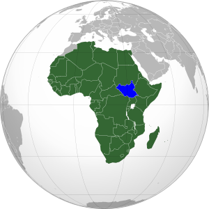
South Sudan (blue) in the A.U. (green). Modified from
this map by Wikimedia user Heraldry (CC BY-SA).

See Also: New Country: South Sudan

Full Story
Less than three weeks after declaring independence, the new Republic of South Sudan has been admitted into the African Union (A.U.). The A.U., which represents all of Africa’s countries except for Morocco, voted with a majority in favor of allowing South Sudan’s entrance into the organization. Membership will allow the new state to participate fully in the community of African nations, while the A.U. is soon to begin mediating talks over the remaining disputes between South Sudan and Sudan, the country from which it seceded this month. South Sudan is the 54th member of the African Union, and the first new member since Eritrea joined in 1993.

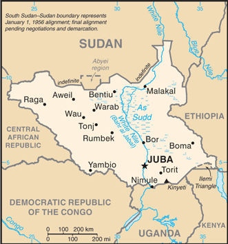
Map of South Sudan from the CIA
World Factbook
(public domain).

See Also: South Sudan Joins U.N.

In addition to A.U. and U.N. membership, South Sudan has continued to receive recognition from individual countries. Official statements of recognition for the new country have now been released by 97 U.N. members and six other sovereign states. Ninety-five U.N. member countries have not yet formally recognized South Sudan, but none have opposed it’s independence – an indication that they all intend to accept it as the world’s newest sovereign state.

Countries which have officially stated their recognition of South Sudan’s sovereignty (green). South Sudan in blue. Modified from this Wikimedia map (public domain).

Wikipedia: South Sudan, Foreign Relations of South Sudan, African Union