
There are newer versions of this map available. To see them, view all Mali maps.
This is an update of yesterday’s Mali conflict map – for the full story, see Mali Map: Islamist Control & French Intervention.
 |
|
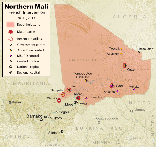
Updated map of territorial control and fighting in Mali, as of Jan. 18, 2013. Map by Evan Centanni, modified from Wikimedia map by Orionist, using images by Carport and NordNordWest (source). License: CC BY-SA.
|

Rebels Lose 2 Towns to French-Malian Forces
The French intervention in Mali has finally resulted in territorial gains for the government, after the two central towns of Konna and Diabaly were reportedly retaken by French and Malian troops today. Mali had incorrectly claimed the recapture of Konna earlier this week, and Diabaly was actually seized by the Islamic extremist rebels after French forces arrived. Local sources have now confirmed both towns to be under government control.
Also today, troops from a Nigerian-led West African force finally began arriving in the country (though they have not yet joined in the combat). Meanwhile, a hostage crisis continued into its third day in neighboring Algeria, where militants closely linked to Al Qaeda have taken over a natural gas field and captured its crew of international workers. By some accounts the militants have demanded an end to the French intervention in Mali, though the location of the gas field is far from Mali’s borders, and they are believed to have attacked from within Algeria.
Full Story: Mali Map: Islamist Control & French Intervention
do you give any credence to reports of the fall of banamba
a town much closer to bamako
mentioned in yesterdays news http://groups.yahoo.com/group/boundarypointpoint/message/2711
but ignored or spaced by later reporting
As far as I know, Banamba was never reported to have fallen – those stories only say militants may have been sighted nearby. The fact that it hasn't been mentioned again probably means that either it didn't end up being true, or else any impending attack was deterred by the large number of troops that should be there by now.
In conflicts like these it's often worthwhile to wait a day or so to see if reports and claims pan out. There are very few journalists active in the area, and as we saw with Douentza and Konna (the first time), claims of a town changing hands without confirmation from local sources often prove unreliable.
French and Malian troopa currently in Niono. Location is very details.
http://www.google.com/hostednews/afp/article/ALeqM5iqomYm5dvqQS55E6YzoEZAuD0PIA?docId=CNG.f72391dd38486d97b3fe9368cebcb662.441
Thanks, Jose. I saw that too. Niono is south of Diabaly, so that's where the French and Malian troops gathered before taking back that town.
According to Reuters TV, French and Malian troops enter Diabaly as Islamist militias vanish. They move out of Diabaly and head east & north.
Tuareg separatist MNLA that started the rebellion in north #Mali wants to join fight against Islamists http://reut.rs/XsS6Ks via @reuters
@BateEtah (Reuters reporter) is currently in Diabaly
Thanks for the tip on @BateEtah. I'll be following him now.
According to my local KABC 7 News pick up news via BBC and Reuters, Militias abandoned Timbuktu and Douentza (re-take by French & Malian trrops). French and Malian troops are move toward Lere.
Douentza was indeed secured on Monday. Updated map here:
Mali Map Update 2: Douentza Secured by Government
Gao was also reportedly abandoned by the rebels in the first few days of French airstrikes, but that's not enough to mark it as "government controlled" until the troops arrive. One thing I've learned from following these kind of conflicts is that if one group is only reported to have "withdrawn", without the other moving in, it's usually not permanent.